Opuatia Peat Bog Management Plan - Waikato Regional Council
Opuatia Peat Bog Management Plan - Waikato Regional Council
Opuatia Peat Bog Management Plan - Waikato Regional Council

Create successful ePaper yourself
Turn your PDF publications into a flip-book with our unique Google optimized e-Paper software.
Air temperature (celsius)<br />
25<br />
20<br />
15<br />
10<br />
5<br />
0<br />
1-Jan<br />
1-Feb<br />
1-Mar<br />
© 2011<br />
1-Apr<br />
1-May<br />
1-Jun<br />
5<br />
1-Jul<br />
Date<br />
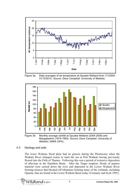
Figure 3a: Daily averages of air temperature at <strong>Opuatia</strong> Wetland from 1/1/2004-<br />
31/12/2010. Source: Dave Campbell, University of <strong>Waikato</strong>.<br />
Rainfall (mm<br />
180<br />
160<br />
140<br />
120<br />
100<br />
80<br />
60<br />
40<br />
20<br />
0<br />
Jan<br />
Feb<br />
Mar<br />
Apr<br />
May<br />
Jun<br />
Jul<br />
Aug<br />
1-Aug<br />
Sep<br />
Oct<br />
1-Sep<br />
Nov<br />
1-Oct<br />
Dec<br />
1-Nov<br />
1-Dec<br />
<strong>Opuatia</strong><br />
Mangatawhiri<br />
Figure 3b: Monthly average rainfall at <strong>Opuatia</strong> Wetland (2004-2009) and<br />
Mangatawhiri (1974-1993). Source: Dave Campbell, University of<br />
<strong>Waikato</strong>; NIWA CliFlo..<br />
4.3 Geology and soils<br />
The lower <strong>Waikato</strong> flood plain had its genesis during the Pleistocene when the<br />
<strong>Waikato</strong> River changed course to meet the sea at Port <strong>Waikato</strong> having previously<br />
flowed into the Firth of Thames. Following this was a period of extensive deposition<br />
of alluvium in the Hamilton Basin. After the Taupo eruption, floods of pumice<br />
material were carried down the river and deposited in the Lower <strong>Waikato</strong> River<br />
forming terraces that blocked off tributaries forming many of the wetlands, including<br />
<strong>Opuatia</strong>, that are found in the Lower <strong>Waikato</strong> Basin today (Cromarty and Scott 1995).<br />
Contract Report No. 2621