Tow Hill Community - Go Haida Gwaii
Tow Hill Community - Go Haida Gwaii
Tow Hill Community - Go Haida Gwaii

Create successful ePaper yourself
Turn your PDF publications into a flip-book with our unique Google optimized e-Paper software.
Legend<br />
<strong>Tow</strong> <strong>Hill</strong> (Taaw)<br />
Suggested Walking<br />
Hiellen Campground<br />
Tour Route<br />
Rose Spit <strong>Haida</strong> Reserve<br />
Cape Fife Trail Naikoon Park<br />
North Beach Beach Access<br />
To: Masset,<br />
Old Massett,<br />
Port<br />
Clements<br />
Note: persons contemplating a visit to Naikoon<br />
Provincial Park are reminded that it is a<br />
wilderness area with limited resources.<br />
Your safety is your responsibility.<br />
Be prepared for emergency situations. Carry<br />
what you will need to rescue yourself and your<br />
vehicle should it become stuck on the beach.<br />
Avoid travelling on the sand dunes as<br />
disturbance can lead to loss of plant life,<br />
erosion, exposure and damage to cultural sites.<br />
Tire tracks and repeated foot traffic through<br />
the sand dunes cause extensive environmental<br />
damage.<br />
Vehicle/ATV use within Naikoon is limited to<br />
between the high and low tide lines of North<br />
and East Beaches; ATV use on interior trails<br />
and sand dune areas is not allowed.<br />
Dixon Entrance <strong>Go</strong>lf<br />
Course & Clubhouse<br />
<strong>Tow</strong> Hil Rd<br />
CFS Masset or<br />
"The Elephant<br />
Cage"<br />
Tsaawan Gandl<br />
(Chown River)<br />
Windsong<br />
Cabin<br />
Rentals<br />
Wendy's Bus<br />
Cafe<br />
<strong>Tow</strong> <strong>Hill</strong> <strong>Community</strong><br />
Access Kiosk<br />
Trout<br />
House<br />
Restaurant<br />
<br />
Limberlost<br />
Lodge<br />
Kelp<br />
Beds<br />
B&B<br />
Skonun River<br />
Beach House B&B<br />
Alaska View<br />
Lodge<br />
South Beach<br />
SGang.an Gandl<br />
(Sangan River)<br />
Dixon Entrance<br />
McIntye Bay<br />
North Beach Cabins<br />
Rapid Ritchie Rustic Rentals<br />
All The Beach You Can Eat<br />
<br />
Walking tour of the<br />
Moon Over Naikoon<br />
Bakery<br />
<br />
<strong>Tow</strong> Hil Rd<br />
SGidlii Gandl<br />
(White Cr)<br />
<strong>Tow</strong> <strong>Hill</strong> <strong>Community</strong><br />
<strong>Tow</strong> <strong>Hill</strong> (Taaw)<br />
<br />
Agate Beach Campground<br />
<br />
Juno<br />
Lake<br />
Yakan Point<br />
Harelda<br />
Lakes<br />
Harlequin<br />
Lake<br />
Hermit<br />
Lake<br />
Hiellen Campground<br />
<br />
Hl’yaalang Gandl<br />
(Hiellen River)<br />
Cygnet<br />
Lake<br />
Spence<br />
Lake<br />
<br />
Imber<br />
Lake<br />
Prospect<br />
Lake<br />
<br />
<br />
North Beach<br />
North<br />
Anser<br />
Lake<br />
Silver<br />
Lake<br />
Kumara<br />
Lake<br />
Mica<br />
Lake<br />
Lumme<br />
Lake<br />
Purdy<br />
Lake<br />
Clearwater<br />
Lake<br />
Xuuya Gandl<br />
(Oeanda River)<br />
Cape Fife<br />
Cape Fife Trail<br />
Rose Spit<br />
Grus<br />
Lake<br />
East Beach<br />
<br />
Hecate Strait<br />
NaikooN Park Hikes<br />
Some of these hikes are in<br />
demanding wilderness, and<br />
all multi-day hikes require<br />
sufficient preparation &<br />
supplies. All water in Naikoon<br />
Park must be treated; water is<br />
undrinkable on North Beach/<br />
north of Cape Fife. Your safety<br />
is your responsibility.<br />
Sangan River Mouth to <strong>Tow</strong><br />
<strong>Hill</strong> - 15 km<br />
Hiellen Campground to Rose<br />
Spit - 22 km<br />
<strong>Tow</strong> <strong>Hill</strong> to Cape Fife - 10 km<br />
<strong>Tow</strong> <strong>Hill</strong> to Tlell via the<br />
Cape Fife Trail - 78 km<br />
<strong>Tow</strong> <strong>Hill</strong> to Tlell via the base of<br />
Rose Spit - 89 km<br />
Cape Fife to Oeanda<br />
River - 17 km<br />
Oeanda River to Cape Ball River<br />
- 36.5 km<br />
Cape Ball River to Tlell<br />
- 10.5 km<br />
Two primitive log shelters are located<br />
near the Cape Ball and Oeanda Rivers,<br />
approximately 2 km south of their<br />
respective river mouths, above the<br />
high tide line. The Fife Point cabin has<br />
a wood stove and is located on the<br />
east beach side of the Cape Fife trail<br />
head. All three shelter locations are<br />
marked with an orange sign posted on<br />
a tree above the beach zone. Please<br />
keep a watchful eye for the signs as you<br />
approach the Cape Ball and Oeanda<br />
Rivers and Fife Point, as they are not<br />
directly obvious from the beach zone.
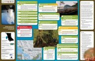
Welcome to the<br />
<strong>Tow</strong> <strong>Hill</strong> <strong>Community</strong> www.towhillroad.ca<br />
The Islands' newest emerging community, <strong>Tow</strong> <strong>Hill</strong> is an area<br />
spread out along <strong>Tow</strong> <strong>Hill</strong> Road - 10km east of Masset. The<br />
<strong>Tow</strong> <strong>Hill</strong> area - known locally as "<strong>Tow</strong> <strong>Tow</strong>n" - runs along<br />
the northwestern boundary of Naikoon Provincial Park and<br />
developments on private lands within the Parks boundaries<br />
has increased the number of people moving to the area.<br />
The main amenities along the roadway include several<br />
rustic cabins for rent in forested, river or beach settings,<br />
a restaurant, café and organic produce store. Surfing is<br />
becoming popular on the Beaches to the north of <strong>Tow</strong> <strong>Hill</strong><br />
Road especially during the winter season. The eastern end<br />
of <strong>Tow</strong> <strong>Hill</strong> Road provides access to Agate Beach Provincial<br />
Campground and North Beach.<br />
With Many Thanks:<br />
towhillroad.ca, gohaidgwaii.ca,<br />
Kathleen Dalzell, Chris Ashurst<br />
Supernatural<br />
Photo credit: Jennifer Bailey<br />
Photo credit: Jennifer Bailey<br />
Photo credit: Jennifer Bailey<br />
<strong>Tow</strong> <strong>Hill</strong> (Taaw)<br />
<strong>Tow</strong> <strong>Hill</strong> consists of faceted columnar-jointed basalt columns, a volcanic plug formation<br />
that is one of the most distinctive features of North Beach. At an elevation of 125m,<br />
<strong>Tow</strong> <strong>Hill</strong> has two interpretive boardwalks; one that leads out to the "Blow Hole" and<br />
another that winds its way up the hill to two viewing platforms. The views of Agate<br />
beach and Yakan Point/North beach are spectacular from these platforms. Taaw (<strong>Tow</strong><br />
<strong>Hill</strong>) is important to the <strong>Haida</strong> people and several legends of significance are attributed<br />
to Taaw.<br />
<strong>Tow</strong> <strong>Hill</strong> Loop Trail: This trail starts at the <strong>Tow</strong> <strong>Hill</strong> day use parking lot and follows the<br />
west bank of the Hiellen River. A sign at the junction will guide you up the boardwalk<br />
for the 15 minute hike to two viewing platforms. One platform provides a spectacular<br />
view of South Beach, Yakan Point and the interior bogs. Please take care to stay on<br />
the boardwalk - there are several hidden cliffs and dangers in this area. Halfway along<br />
this trail you will come to a junction directing you to the Blow Hole, which is at the<br />
base of <strong>Tow</strong> <strong>Hill</strong> - another 15 minutes and you're on the rocky shoreline. The Blow<br />
Hole is best viewed at mid-tide - watch out for slippery footing. Total loop distance is<br />
approximately 2 km.<br />
Hiellen Campground / Reserve<br />
Hiellen Reserve is a 70.5 acre area owned by the Massett band, and was the site of<br />
several important <strong>Haida</strong> villages. This location continues to be a very important food<br />
gathering place for the <strong>Haida</strong>; razor clams digging, crabbing and fishing are done here.<br />
Permission was obtained to build a clam cannery here in 1923 and it ran seasonally<br />
until 1930 - you can see the remains of the boiler close the river near the beach access.<br />
There are camping sites, pit toilets and parking available.<br />
Rose Spit<br />
The sand bars of Rose Spit extend outward 14 km from this point and are a dicey<br />
proposition for any ship to cross. Ever changing, Rose Spit is being formed by southeast<br />
gales eroding the east beach coastline and driving the sand northwards, where the<br />
turbulent waters of Dixon Entrance and the Hecate Strait meet. Rose Spit is an area of<br />
high importance to the <strong>Haida</strong> people, and is known as NAIKUN "the long nose of Nai"<br />
- one of the <strong>Haida</strong> creation stories involves Raven finding a cockle shell on the beach,<br />
filled with humans struggling inside, and coaxing the humans out.<br />
Cape Fife Trail<br />
The Cape Fife trail starts just<br />
past the <strong>Tow</strong> <strong>Hill</strong> day use parking<br />
lot and the Hiellen River. Signs<br />
will guide you to the trail head.<br />
The trail crosses the Argonaut<br />
Plain and spectacular bog<br />
environments. Some portions<br />
of the trail are boardwalk. 10km<br />
one way (4 hours approximate).<br />
The Cape Fife shelter is located at<br />
the end of the trail on East Beach.<br />
Accommodation<br />
Alternatively, you can try the Cape Fife Loop - A two/three day wilderness hike through<br />
costal forest, bogs and along sandy beaches to Rose Spit. Hike Cape Fife trail to East<br />
Beach shelter - then turn northwards along the beach to Rose Spit. Follow North Beach<br />
back to <strong>Tow</strong> <strong>Hill</strong> day use area. Approximately 35km return trip.<br />
North Beach<br />
Alaska View Lodge • 250-626-3333<br />
All The Beach You Can Eat • 604-313-6192<br />
The Beach House B&B • 250-626-6040<br />
Hidden Island Guest house • 250-626-5286<br />
Highwater House • 250-559-8133<br />
Kelp Beds • 250-626-3895<br />
Wide open sandy, pebbled beaches spilling over with driftwood along the northern<br />
coastline of Graham Island. It is easy to access by foot or car which is a big reason why<br />
this beach attracts people to the area for beach combing, hiking, surfing, fishing, clam<br />
digging, ATVing and relaxing. The beaches offers up some of the best ocean views,<br />
waterfront experiences and peaceful moments available while visiting on <strong>Haida</strong> <strong>Gwaii</strong>.<br />
North Beach is mainly hard packed wet sand at low tide when the ocean waters retreat<br />
exposing miles of beach for all to see and play in. During the winter, both beaches<br />
become storm watching destinations - Nature's power on display with huge waves<br />
and howling winds smashing the coastline. It is always wise to pack good rain gear on<br />
an outdoor storm watching adventure or any adventure for that matter! Layer your<br />
clothing, bring a hat and gloves if brave enough to venture outdoors in a west coast<br />
storm. Some stay in a vehicle and watch the storms from the car, Agate Beach is good<br />
for that. A good description of the North Beach area:<br />
"Nellie Hammond knew nothing about cooking, but being very much in love and<br />
realizing that her husband wanted to try pioneering at <strong>Tow</strong> <strong>Hill</strong> she agreed (to join<br />
him.) 'Never will I forget that ride out along that beach. The majesty of those big trees<br />
and the huge breakers rolling in along the shore – I felt as though <strong>Go</strong>d were very near,<br />
and it seemed to be the loveliest place in all the world.'"<br />
- from The Queen Charlotte Islands, Volume 1 1774-1966 by Kathleen Dalzell<br />
Emergency Services<br />
Photo credit: Kayla Bailey<br />
Police • 250-626-3991<br />
Ambulance • 1-888-461-9911<br />
Masset Fire Department • 250-626-5511<br />
Masset Health Clinic • 250-626-4702<br />
Coast Guard • 1-800-567-5111<br />
Limberlost Lodge • 250-626-3371<br />
New Moon Over Naikoon Cabins •<br />
250-626-7737<br />
North Beach Cabins • 250-557-2415<br />
Rapid Ritchie's Beach Cabins • 250-626-5472<br />
Windsong Cottage Rentals • 250-626-3625