Digest of Hunting and Trapping Regulation - Pennsylvania Envirothon
Digest of Hunting and Trapping Regulation - Pennsylvania Envirothon
Digest of Hunting and Trapping Regulation - Pennsylvania Envirothon

Create successful ePaper yourself
Turn your PDF publications into a flip-book with our unique Google optimized e-Paper software.
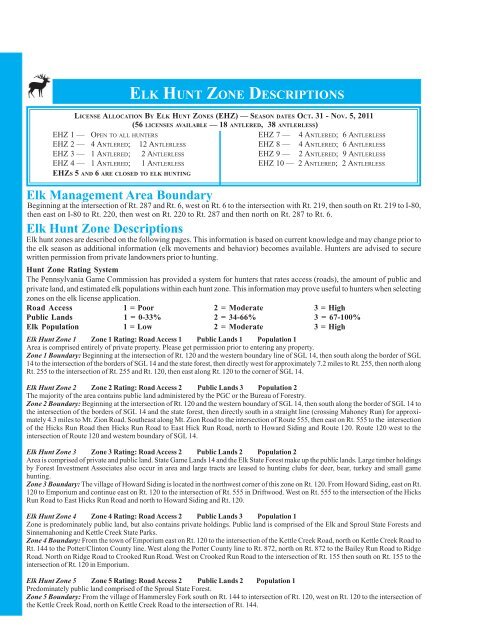
ELK HUNT ZONE DESCRIPTIONS<br />
LICENSE ALLOCATION BY ELK HUNT ZONES (EHZ) — SEASON DATES OCT. 31 - NOV. 5, 2011<br />
(56 LICENSES AVAILABLE — 18 ANTLERED, 38 ANTLERLESS)<br />
EHZ 1 — OPEN TO ALL HUNTERS<br />
EHZ 7 — 4 ANTLERED; 6 ANTLERLESS<br />
EHZ 2 — 4 ANTLERED; 12 ANTLERLESS<br />
EHZ 8 — 4 ANTLERED; 6 ANTLERLESS<br />
EHZ 3 — 1 ANTLERED; 2 ANTLERLESS<br />
EHZ 9 — 2 ANTLERED; 9 ANTLERLESS<br />
EHZ 4 — 1 ANTLERED; 1 ANTLERLESS<br />
EHZ 10 — 2 ANTLERED; 2 ANTLERLESS<br />
EHZS 5 AND 6 ARE CLOSED TO ELK HUNTING<br />
Elk Management Area Boundary<br />
Beginning at the intersection <strong>of</strong> Rt. 287 <strong>and</strong> Rt. 6, west on Rt. 6 to the intersection with Rt. 219, then south on Rt. 219 to I-80,<br />
then east on I-80 to Rt. 220, then west on Rt. 220 to Rt. 287 <strong>and</strong> then north on Rt. 287 to Rt. 6.<br />
Elk Hunt Zone Descriptions<br />
Elk hunt zones are described on the following pages. This information is based on current knowledge <strong>and</strong> may change prior to<br />
the elk season as additional information (elk movements <strong>and</strong> behavior) becomes available. Hunters are advised to secure<br />
written permission from private l<strong>and</strong>owners prior to hunting.<br />
Hunt Zone Rating System<br />
The <strong>Pennsylvania</strong> Game Commission has provided a system for hunters that rates access (roads), the amount <strong>of</strong> public <strong>and</strong><br />
private l<strong>and</strong>, <strong>and</strong> estimated elk populations within each hunt zone. This information may prove useful to hunters when selecting<br />
zones on the elk license application.<br />
Road Access 1 = Poor 2 = Moderate 3 = High<br />
Public L<strong>and</strong>s 1 = 0-33% 2 = 34-66% 3 = 67-100%<br />
Elk Population 1 = Low 2 = Moderate 3 = High<br />
Elk Hunt Zone 1 Zone 1 Rating: Road Access 1 Public L<strong>and</strong>s 1 Population 1<br />
Area is comprised entirely <strong>of</strong> private property. Please get permission prior to entering any property.<br />
Zone 1 Boundary: Beginning at the intersection <strong>of</strong> Rt. 120 <strong>and</strong> the western boundary line <strong>of</strong> SGL 14, then south along the border <strong>of</strong> SGL<br />
14 to the intersection <strong>of</strong> the borders <strong>of</strong> SGL 14 <strong>and</strong> the state forest, then directly west for approximately 7.2 miles to Rt. 255, then north along<br />
Rt. 255 to the intersection <strong>of</strong> Rt. 255 <strong>and</strong> Rt. 120, then east along Rt. 120 to the corner <strong>of</strong> SGL 14.<br />
Elk Hunt Zone 2 Zone 2 Rating: Road Access 2 Public L<strong>and</strong>s 3 Population 2<br />
The majority <strong>of</strong> the area contains public l<strong>and</strong> administered by the PGC or the Bureau <strong>of</strong> Forestry.<br />
Zone 2 Boundary: Beginning at the intersection <strong>of</strong> Rt. 120 <strong>and</strong> the western boundary <strong>of</strong> SGL 14, then south along the border <strong>of</strong> SGL 14 to<br />
the intersection <strong>of</strong> the borders <strong>of</strong> SGL 14 <strong>and</strong> the state forest, then directly south in a straight line (crossing Mahoney Run) for approximately<br />
4.3 miles to Mt. Zion Road. Southeast along Mt. Zion Road to the intersection <strong>of</strong> Route 555, then east on Rt. 555 to the intersection<br />
<strong>of</strong> the Hicks Run Road then Hicks Run Road to East Hick Run Road, north to Howard Siding <strong>and</strong> Route 120. Route 120 west to the<br />
intersection <strong>of</strong> Route 120 <strong>and</strong> western boundary <strong>of</strong> SGL 14.<br />
Elk Hunt Zone 3 Zone 3 Rating: Road Access 2 Public L<strong>and</strong>s 2 Population 2<br />
Area is comprised <strong>of</strong> private <strong>and</strong> public l<strong>and</strong>. State Game L<strong>and</strong>s 14 <strong>and</strong> the Elk State Forest make up the public l<strong>and</strong>s. Large timber holdings<br />
by Forest Investment Associates also occur in area <strong>and</strong> large tracts are leased to hunting clubs for deer, bear, turkey <strong>and</strong> small game<br />
hunting.<br />
Zone 3 Boundary: The village <strong>of</strong> Howard Siding is located in the northwest corner <strong>of</strong> this zone on Rt. 120. From Howard Siding, east on Rt.<br />
120 to Emporium <strong>and</strong> continue east on Rt. 120 to the intersection <strong>of</strong> Rt. 555 in Driftwood. West on Rt. 555 to the intersection <strong>of</strong> the Hicks<br />
Run Road to East Hicks Run Road <strong>and</strong> north to Howard Siding <strong>and</strong> Rt. 120.<br />
Elk Hunt Zone 4 Zone 4 Rating: Road Access 2 Public L<strong>and</strong>s 3 Population 1<br />
Zone is predominately public l<strong>and</strong>, but also contains private holdings. Public l<strong>and</strong> is comprised <strong>of</strong> the Elk <strong>and</strong> Sproul State Forests <strong>and</strong><br />
Sinnemahoning <strong>and</strong> Kettle Creek State Parks.<br />
Zone 4 Boundary: From the town <strong>of</strong> Emporium east on Rt. 120 to the intersection <strong>of</strong> the Kettle Creek Road, north on Kettle Creek Road to<br />
Rt. 144 to the Potter/Clinton County line. West along the Potter County line to Rt. 872, north on Rt. 872 to the Bailey Run Road to Ridge<br />
Road. North on Ridge Road to Crooked Run Road. West on Crooked Run Road to the intersection <strong>of</strong> Rt. 155 then south on Rt. 155 to the<br />
intersection <strong>of</strong> Rt. 120 in Emporium.<br />
Elk Hunt Zone 5 Zone 5 Rating: Road Access 2 Public L<strong>and</strong>s 2 Population 1<br />
Predominately public l<strong>and</strong> comprised <strong>of</strong> the Sproul State Forest.<br />
Zone 5 Boundary: From the village <strong>of</strong> Hammersley Fork south on Rt. 144 to intersection <strong>of</strong> Rt. 120, west on Rt. 120 to the intersection <strong>of</strong><br />
the Kettle Creek Road, north on Kettle Creek Road to the intersection <strong>of</strong> Rt. 144.