Download the Greenlee Lough leaflet - Northumberland National Park
Download the Greenlee Lough leaflet - Northumberland National Park
Download the Greenlee Lough leaflet - Northumberland National Park

Create successful ePaper yourself
Turn your PDF publications into a flip-book with our unique Google optimized e-Paper software.
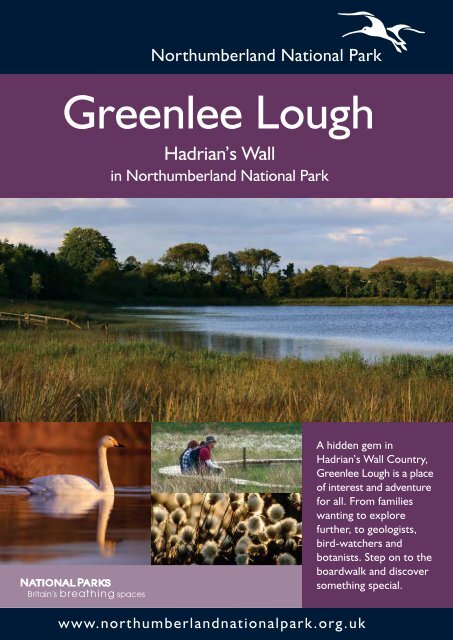
<strong>Greenlee</strong> <strong>Lough</strong><br />
Hadrian’s Wall<br />
in <strong>Northumberland</strong> <strong>National</strong> <strong>Park</strong><br />
ww w.northumberlandnationalpark.org.uk<br />
A hidden gem in<br />
Hadrian’s Wall Country,<br />
<strong>Greenlee</strong> <strong>Lough</strong> is a place<br />
of interest and adventure<br />
for all. From families<br />
wanting to explore<br />
fur<strong>the</strong>r, to geologists,<br />
bird-watchers and<br />
botanists. Step on to <strong>the</strong><br />
boardwalk and discover<br />
something special.
0<br />
0<br />
<strong>Greenlee</strong> <strong>Lough</strong> Walk<br />
Farm Walk<br />
Right of Way<br />
Pennine Way and Hadrian’s Wall<br />
Path <strong>National</strong> Trail<br />
<strong>National</strong> <strong>Park</strong> Centre, Once Brewed<br />
Car <strong>Park</strong><br />
Tourist Information<br />
Toilets<br />
Refreshments available<br />
(Permissive<br />
Car <strong>Park</strong>)<br />
1 km<br />
0.6 0 mile<br />
N<br />
<strong>National</strong> <strong>Park</strong> Centre 1/2 mile<br />
Please use an Ordnance Survey Map on this walk<br />
Reproduced by permission of Ordnance Survey on behalf of HMSO<br />
© Crown copyright and database right 2010. All right reserved.<br />
Ordnance Survey Licence Number 100022521.<br />
Map illustration © Mike Ritchie MR2 2011<br />
A circular walk to <strong>Greenlee</strong> <strong>Lough</strong><br />
Grade: Moderate | Distance: 3.8 miles (6 km) | Time: 2 hours<br />
Map: OS OL43 1:25000 Hadrian’s Wall | Start OS Grid Ref: NY 747 690<br />
<strong>Park</strong>ing: Limited parking at <strong>the</strong> Permissive Car <strong>Park</strong> north of Steel Rigg,<br />
if this is full please park at Steel Rigg Car <strong>Park</strong><br />
Nearest <strong>National</strong> <strong>Park</strong> Centre: Once Brewed |<br />
Toilets: Once Brewed | Local Services: Haltwhistle and Haydon Bridge<br />
Terrain: Footpaths, agricultural land, rough fell, boardwalk and minor roads;<br />
ground may be boggy in places<br />
A Leave <strong>the</strong> Permissive Car <strong>Park</strong> and<br />
turn right along <strong>the</strong> minor road. Cross <strong>the</strong><br />
Caw Burn over <strong>the</strong> hump back bridge<br />
and head uphill.<br />
B When you get to <strong>the</strong> finger post on <strong>the</strong><br />
left, signed ‘<strong>Greenlee</strong> Nature Reserve’, go<br />
through <strong>the</strong> wicket gate and walk over <strong>the</strong><br />
‘fell ground’ following <strong>the</strong> line of <strong>the</strong> electricity<br />
poles. Go through three wicket gates, carry<br />
on along <strong>the</strong> side of <strong>the</strong> wood to <strong>the</strong> start<br />
of <strong>the</strong> boardwalk.<br />
C Walk along <strong>the</strong> boardwalk. This was<br />
installed by <strong>Northumberland</strong> <strong>National</strong> <strong>Park</strong><br />
Authority to protect <strong>the</strong> fragile wetland habitat<br />
on <strong>the</strong> edge of <strong>the</strong> <strong>Lough</strong>. It was funded by<br />
Natural England through a Higher Level<br />
Stewardship Scheme. Please keep to <strong>the</strong><br />
boardwalk at all times, and take care when<br />
<strong>the</strong> boardwalk is wet, or in times of flood.<br />
D At <strong>the</strong> junction keep to <strong>the</strong> boardwalk<br />
that heads around <strong>the</strong> <strong>Lough</strong>. As you<br />
continue on you will notice that you are<br />
walking through <strong>the</strong> ‘reed beds’.<br />
E At <strong>the</strong> end of <strong>the</strong> boardwalk follow <strong>the</strong><br />
waymarked path with <strong>the</strong> fence on your left<br />
over rough ground. Go through <strong>the</strong> wicket<br />
gate at <strong>the</strong> corner of <strong>the</strong> wood. Continue<br />
along <strong>the</strong> edge of woodland, with <strong>the</strong> fence<br />
on your right passing over a small sleeper<br />
bridge and through <strong>the</strong> hay meadow which<br />
is at its best in late June-early July.<br />
F Climb over <strong>the</strong> stile on your right and<br />
go through <strong>the</strong> woodland to <strong>the</strong> Bird Hide.<br />
This is an ideal place to stop and look at <strong>the</strong><br />
wildlife of <strong>the</strong> <strong>Lough</strong>. Retrace your steps<br />
back to <strong>the</strong> stile and turn right continuing<br />
through <strong>the</strong> meadow.<br />
G At <strong>the</strong> finger post turn left following <strong>the</strong><br />
grass track and walk uphill towards <strong>Greenlee</strong><br />
Farm House. Follow <strong>the</strong> footpath around<br />
<strong>the</strong> farm and turn left onto <strong>the</strong> farm track.<br />
Follow <strong>the</strong> track back to <strong>the</strong> Permissive Car<br />
<strong>Park</strong>. From here <strong>the</strong>re are good views of<br />
Winshield Crags and <strong>the</strong> North Pennines.
The walk to <strong>Greenlee</strong> <strong>Lough</strong> takes you through a<br />
mosaic of habitats, which can look very different<br />
depending on <strong>the</strong> time of year. The birdlife and insects<br />
<strong>the</strong>se habitats support also change with <strong>the</strong> season,<br />
so regular visits are recommended! Check our<br />
website for <strong>the</strong> wildlife calendar.<br />
Try visiting at dawn or dusk, a good time to see shy<br />
deer or foxes returning from a night’s hunting.<br />
View of <strong>the</strong> Great Whin Sill from <strong>Greenlee</strong> <strong>Lough</strong><br />
A variety of Sphagnum moss<br />
Geology and <strong>the</strong> Great Whin Sill<br />
The landscape here is dominated by <strong>the</strong><br />
impressive ridge of crags and columns that<br />
form <strong>the</strong> Great Whin Sill - <strong>the</strong> natural rampart<br />
that <strong>the</strong> Romans exploited when building<br />
Hadrian’s Wall. This geological feature was<br />
formed 295 million years ago when, at<br />
10,000˚c, molten rock pushed between<br />
layers of sandstone and limestone, gradually<br />
cooling over <strong>the</strong> next 50 years.<br />
<strong>Lough</strong>s and mires<br />
A lough (pronounced loff) is<br />
<strong>the</strong> local word for a lake. In<br />
<strong>Northumberland</strong> loughs were<br />
formed by <strong>the</strong> slow, gradual flow<br />
of ice, beginning about 2 million<br />
years ago. <strong>Lough</strong>s were left when <strong>the</strong>se massive amounts of moving ice were able to carve<br />
out deep hollows in soft rock such as mudstones and shale. In shallower hollows, peat bogs<br />
have formed made up of plants such as sphagnum mosses that thrive in <strong>the</strong>se permanently<br />
wet, acidic conditions.<br />
Bog Asphodel<br />
Emperor Moth caterpillar<br />
Meadow Pipit<br />
Emperor Moth<br />
Large Heath Butterfly<br />
Common Lizard<br />
Otter<br />
Jacob Sheep<br />
Skylark<br />
Deep peat and <strong>the</strong> boardwalk<br />
The 500 metre boardwalk funded by Natural<br />
England through a Higher Level Stewardship<br />
Scheme and put in by <strong>Northumberland</strong><br />
<strong>National</strong> <strong>Park</strong> Voluntary Rangers and Trainees<br />
in 2009, takes you over very fragile deep peat<br />
that would o<strong>the</strong>rwise be too wet and<br />
damaging to walk over.<br />
Sponge-like sphagnum mosses are <strong>the</strong> dominant<br />
plants here, but look carefully for bog asphodel,<br />
cranberry, cotton grass and round-leaved sundew.<br />
Some insects can only survive on <strong>the</strong>se plant<br />
species. Adult large heath butterfly feed on bog<br />
asphodel nectar and <strong>the</strong>ir caterpillars feed on<br />
<strong>the</strong> two types of cotton grass that grow here.<br />
O<strong>the</strong>r insects include <strong>the</strong> small heath and pearl<br />
bordered butterflies and Emperor moth.<br />
The boardwalk sometimes allows for good<br />
sightings of frogs, toads and common lizards.<br />
Even if you don’t spot a live specimen look<br />
carefully for wildlife clues such as fox droppings<br />
and owl pellets. The bridge taking you over <strong>the</strong><br />
small burn is a good place to look for <strong>the</strong><br />
footprints in <strong>the</strong> mud of birds or even otters.<br />
Round-leaved Sundew Cranberry<br />
Fell ground<br />
This is <strong>the</strong> rough pasture that you walk over<br />
before reaching <strong>the</strong> boardwalk.<br />
Local farmers favour traditional sheep and<br />
cattle, such as horned, rough coated Highland<br />
cattle and spotty, horned Jacob sheep. These<br />
breeds are hardy in what can be a harsh<br />
climate, and thrive on <strong>the</strong> rushes and tough<br />
grasses which make up this grazing land. O<strong>the</strong>r<br />
livestock seen in <strong>the</strong> area are Scottish Blackfaced<br />
and Cheviot sheep and Beef Shorthorn,<br />
Belted Galloway and Blue Grey cattle.<br />
Birdlife here include meadow pipit and skylark<br />
which are easy to hear and possible to spot<br />
hovering in <strong>the</strong> air.<br />
Goldeneye<br />
Shelduck Mallard Great Crested Grebe<br />
Coot<br />
<strong>Greenlee</strong> <strong>Lough</strong><br />
<strong>Greenlee</strong> <strong>Lough</strong> is one of <strong>the</strong> most important<br />
wetland sites in Britain and Europe. It contains<br />
unusual aquatic plantlife including several types of<br />
pondweed and stonewort (types of algae thriving in<br />
very clean water). This has led to its designation as<br />
a Special Area of Conservation, a Site of Special<br />
Scientific Interest and a <strong>National</strong> Nature Reserve.<br />
It is <strong>the</strong> largest natural freshwater lake in<br />
<strong>Northumberland</strong>, but is only 1.8 metres at its<br />
deepest point.<br />
Creatures in <strong>the</strong> lough include pike, perch, roach,<br />
eels and native white clawed crayfish. These<br />
provide food for otters that make <strong>the</strong>ir homes in<br />
<strong>the</strong> surrounding vegetation and woodlands.<br />
Newly planted woodland<br />
Trees that thrive in wet conditions such as<br />
alder and several types of willow fringe <strong>the</strong><br />
lough and are scattered around <strong>the</strong> site. To<br />
add to this, new native woodland has been<br />
planted. These include rowan, oak and<br />
hawthorn as well as more alder and willow.<br />
Alder<br />
White Clawed Crayfish<br />
Willow<br />
Teal<br />
Greylag Goose<br />
The site is important for wildfowl (geese, swans<br />
and ducks) particularly in <strong>the</strong> winter when<br />
whooper swan, greylag geese, wigeon, teal,<br />
goldeneye, tufted duck and mallard can be seen.<br />
In spring and summer you can look for mute<br />
swan, mallard, coot, shelduck and great crested<br />
grebe. The bird hide is open all year round and<br />
has information to help you identify plants, birds<br />
and animals of interest. You can also record<br />
what you have spotted. Many visitors have<br />
recorded osprey visiting <strong>the</strong> lough recently so<br />
we are hopeful <strong>the</strong>se magnificent birds may<br />
choose to breed here.<br />
Bird<br />
Hide<br />
GREENLEE<br />
LOUGH<br />
Reedbed<br />
Heron<br />
Stonewort<br />
This is an uncommon habitat in <strong>Northumberland</strong>,<br />
particularly at this altitude, 230m above sea level.<br />
Walking along <strong>the</strong> boardwalk is like being in a<br />
secret world. The reedbed is dominated by<br />
common reed which can grow to 4 metres high -<br />
try spotting birds on <strong>the</strong> lough whilst you are<br />
hidden from view.<br />
In <strong>the</strong> winter listen to <strong>the</strong> rustle of dead reed stems,<br />
which will be replaced in <strong>the</strong> spring and summer<br />
by <strong>the</strong> calls of reed bunting and sedge warbler.<br />
Bottle Sedge<br />
Marsh Cinquefoil Common Darter Dragonfly<br />
Marsh Marigold Devils-bit Scabious<br />
Reed Mace<br />
Fen<br />
The band of vegetation fringing <strong>the</strong> lough is made up of bottle sedge (dark green), water<br />
horsetail (lighter green) and smaller amounts of reed mace and branched bur-reed.<br />
This blends into a species-rich fen. How many of <strong>the</strong> different plants pictured here can you spot?<br />
The abundance of plant species here supports many insects and birds. In spring and summer you<br />
can see common blue, large red and azure damselflies and <strong>the</strong> common darter dragonfly. Listen for<br />
<strong>the</strong> distinctive, reeling bird-call of <strong>the</strong> grasshopper warbler.<br />
Cotton Grass<br />
Hay meadows<br />
Horsetail<br />
Common Blue Damselfly<br />
Forget-me-not<br />
Skullcap<br />
Grasshopper Warbler<br />
Meadowsweet<br />
The boardwalk<br />
Common Frog<br />
Angelica<br />
Sneezewort<br />
At <strong>the</strong> end of <strong>the</strong> boardwalk you will walk through fields which are<br />
managed as hay meadows. This means using manure to feed <strong>the</strong> land,<br />
ra<strong>the</strong>r than nitrogen-rich fertiliser, and cutting for hay late in <strong>the</strong> season.<br />
In June and July this traditional way of managing farm land leads to a<br />
rich variety of flowering plants such as yellow rattle, pignut, red clover<br />
and vetches, <strong>the</strong>se in turn encourages more diverse insect life.<br />
Yellow Flag Iris<br />
Common Valerian<br />
Branched Bur-reed<br />
Reed Canary Grass<br />
Buttercup & Red Clover<br />
Common Reed Sedge Warbler Reed Bunting Tufted Vetch Yellow Rattle
<strong>Greenlee</strong> <strong>Lough</strong>, a hidden gem<br />
Common Toad<br />
Wigeon<br />
All photographs ©: Laurie Campbell, Peter Eeles, Simon Fraser, Shaun Hackett, North East Wildlife, Allan Potts, Mandy Roberts, Peter Skelton,<br />
Joan Thirlaway, NNPA. Map illustration © Mike Ritchie<br />
Osprey<br />
The Bird Hide<br />
<strong>Northumberland</strong> <strong>National</strong> <strong>Park</strong> Authority purchased <strong>Greenlee</strong> <strong>Lough</strong> and <strong>the</strong> important<br />
wetland habitats around it in 1991 in order to manage and promote this jewel as a nature<br />
reserve. The <strong>Park</strong> Authority also owns and manages land to <strong>the</strong> north and west of <strong>the</strong> <strong>Lough</strong>.<br />
How to reach <strong>Greenlee</strong> <strong>Lough</strong>:<br />
From <strong>the</strong> West: Follow <strong>the</strong> B6318 (Military Road) from Greenhead to <strong>the</strong> cross-roads with<br />
<strong>the</strong> <strong>National</strong> <strong>Park</strong> Centre at Once Brewed. Turn left signposted ‘Steel Rigg’.<br />
From <strong>the</strong> East: Follow <strong>the</strong> B6318 (Military Road) west to <strong>the</strong> cross-roads with <strong>the</strong> <strong>National</strong><br />
<strong>Park</strong> Centre at Once Brewed. Turn right signposted ‘Steel Rigg’.<br />
The Hadrian’s Wall bus AD122 stops at <strong>the</strong> <strong>National</strong> <strong>Park</strong> Centre at Once Brewed on <strong>the</strong><br />
B6318 (Military Road). Walk up <strong>the</strong> narrow road signed ‘Steel Rigg’ to start <strong>the</strong> walk.<br />
www.traveline.info<br />
© Crown copyright and database rights (2011)<br />
Ordnance Survey (Licence Number 100022521)<br />
Please Note:<br />
Please follow <strong>the</strong> Countryside Code:<br />
Be safe - plan ahead and follow signs<br />
Leave gates and property as you find <strong>the</strong>m<br />
Protect plants and animals, and take your litter home<br />
Keep dogs under close control<br />
Consider o<strong>the</strong>r people<br />
Supported by<br />
The walk to <strong>Greenlee</strong> <strong>Lough</strong>, beginning and<br />
returning at <strong>the</strong> permissive car park and using<br />
permissive routes and footpaths is 3.8 miles.<br />
To explore fur<strong>the</strong>r, please use Ordnance Survey<br />
map OL43 Hadrian’s Wall.<br />
Good footwear is recommended.<br />
Nearest <strong>National</strong> <strong>Park</strong> Centre:<br />
<strong>National</strong> <strong>Park</strong> Centre, Once Brewed, NE47 7AN<br />
T:+44 (0)1434 344396<br />
<strong>Northumberland</strong> <strong>National</strong> <strong>Park</strong> Authority, Eastburn, South <strong>Park</strong>, Hexham, <strong>Northumberland</strong> NE46 1BS<br />
Front cover photographs ©: <strong>Greenlee</strong> <strong>Lough</strong>, Cotton Grass, Whooper Swan, The Boardwalk<br />
The site is exposed, so prepare for <strong>the</strong> wea<strong>the</strong>r -<br />
this may mean waterproofs or sun-cream<br />
depending on <strong>the</strong> forecast and <strong>the</strong> time of year.<br />
Respect livestock by keeping dogs on a lead and<br />
taking extra care not to approach lambs or calves.<br />
March 2011