Dune Slack Vegetation of the Wadden Sea Islands
Dune Slack Vegetation of the Wadden Sea Islands
Dune Slack Vegetation of the Wadden Sea Islands

Create successful ePaper yourself
Turn your PDF publications into a flip-book with our unique Google optimized e-Paper software.
12<br />
<strong>Dune</strong> <strong>Slack</strong>s<br />
Jörg Petersen, Institute <strong>of</strong><br />
Geobotany, University <strong>of</strong><br />
Hannover, FRG<br />
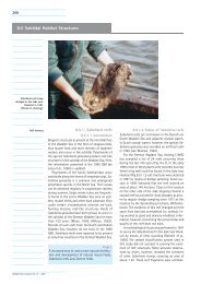
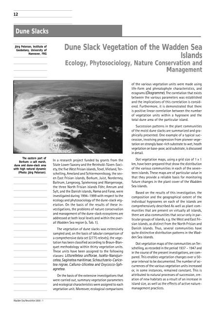
The eastern part <strong>of</strong><br />
Borkum: a salt marsh,<br />
dune and dune-slack area<br />
with high natural dynamic<br />
(Photo: Jörg Petersen).<br />
<strong>Wadden</strong> <strong>Sea</strong> Newsletter 2000 - 1<br />
<strong>Dune</strong> <strong>Slack</strong> <strong>Vegetation</strong> <strong>of</strong> <strong>the</strong> <strong>Wadden</strong> <strong>Sea</strong><br />
<strong>Islands</strong><br />
Ecology, Phytosociology, Nature Conservation and<br />
Management<br />
In a research project funded by grants from <strong>the</strong><br />
State Lower Saxony and <strong>the</strong> Reinhold-Tüxen-Society,<br />
<strong>the</strong> five West Frisian islands, Texel, Vlieland, Terschelling,<br />
Ameland and Schiermonnikoog, <strong>the</strong> seven<br />
East Frisian islands, Borkum, Juist, Norderney,<br />
Baltrum, Langeoog, Spiekeroog and Wangerooge,<br />
<strong>the</strong> three North Frisian islands Föhr, Amrum and<br />
Sylt, and <strong>the</strong> Danish islands, Rømø and Fanø, were<br />
investigated during 1994–1999 with respect to <strong>the</strong><br />
ecology and phytosociology <strong>of</strong> <strong>the</strong> dune-slack vegetation.<br />
On <strong>the</strong> basis <strong>of</strong> <strong>the</strong> results <strong>of</strong> <strong>the</strong>se investigations,<br />
<strong>the</strong> problems <strong>of</strong> nature conservation<br />
and management <strong>of</strong> <strong>the</strong> dune-slack ecosystems are<br />
addressed at both local levels and within <strong>the</strong> overall<br />
<strong>Wadden</strong> <strong>Sea</strong> region (s. Tab. 1).<br />
The vegetation <strong>of</strong> dune slacks was extensively<br />
sampled and, on <strong>the</strong> basis <strong>of</strong> tabular comparison <strong>of</strong><br />
a comprehensive data set (2775 relevés), <strong>the</strong> vegetation<br />
has been classified according to Braun-Blanquet<br />
methodology within thirty vegetation units.<br />
These units have been assigned to <strong>the</strong> following<br />
classes: Littorelletea uniflorae, Isoëto-Nanojuncetea,<br />
Saginetea maritimae, Scheuchzerio-Caricetea<br />
nigrae, Calluno-Ulicetea and Oxycocco-Sphagnetea.<br />
On <strong>the</strong> basis <strong>of</strong> <strong>the</strong> extensive investigations that<br />
were carried out, summary vegetation parameters<br />
and ecological characteristics were assigned to each<br />
vegetation unit. Moreover, ecological comparisons<br />
<strong>of</strong> <strong>the</strong> various vegetation units were made using<br />
life-form and phreatophyte characteristics, and<br />
ecograms (Ökogramme). The correlation that exists<br />
between <strong>the</strong> various parameters was established<br />
and <strong>the</strong> implications <strong>of</strong> this correlation is considered.<br />
Fur<strong>the</strong>rmore, it is demonstrated that <strong>the</strong>re<br />
is positive linear correlation between <strong>the</strong> number<br />
<strong>of</strong> vegetation units within a hygrosere and <strong>the</strong><br />
total dune area <strong>of</strong> <strong>the</strong> particular island.<br />
Succession patterns in <strong>the</strong> plant communities<br />
<strong>of</strong> <strong>the</strong> moist dune slacks are summarized and graphically<br />
presented. One example <strong>of</strong> a typical succession,<br />
involving progression from pioneer vegetation<br />
on strongly base-rich substrate to wet, heath<br />
vegetation on base-poor, acid substrate, is discussed<br />
in detail.<br />
Dot vegetation maps, using a grid size <strong>of</strong> 1 x 1<br />
km, have been prepared that show <strong>the</strong> distribution<br />
<strong>of</strong> <strong>the</strong> various communities in each <strong>of</strong> <strong>the</strong> seventeen<br />
islands. These maps are <strong>of</strong> particular value in<br />
that <strong>the</strong>y provide a reliable basis for monitoring<br />
future changes in <strong>the</strong> plant cover <strong>of</strong> <strong>the</strong> <strong>Wadden</strong><br />
<strong>Sea</strong> islands.<br />
Based on <strong>the</strong> results <strong>of</strong> this investigation, <strong>the</strong><br />
composition and <strong>the</strong> geographical extent <strong>of</strong> <strong>the</strong><br />
individual hygroseres on each <strong>of</strong> <strong>the</strong> islands are<br />
comprehensively described As well as plant communities<br />
that are present on virtually all islands,<br />
<strong>the</strong>re are also communities that occur only in particular<br />
groups <strong>of</strong> islands, e.g. <strong>the</strong> West and East Frisian<br />
islands, as distinct from <strong>the</strong> North Frisian and<br />
Danish islands. Thus, several communities have<br />
quite distinctive distribution patterns in <strong>the</strong> <strong>Wadden</strong><br />
<strong>Sea</strong> islands.<br />
Dot vegetation maps <strong>of</strong> <strong>the</strong> communities on Terschelling,<br />
as recorded in <strong>the</strong> period 1937 - 1947 and<br />
in <strong>the</strong> course <strong>of</strong> <strong>the</strong> present investigations, are compared.<br />
This enables vegetation changes over a 50year<br />
interval to be documented. The number <strong>of</strong> occurrences<br />
<strong>of</strong> <strong>the</strong> various vegetation units increased<br />
or, in some instances, remained constant. This is<br />
attributed to natural processes <strong>of</strong> succession, creation<br />
<strong>of</strong> new habitats as a result <strong>of</strong> an increase in<br />
island size, as well as <strong>the</strong> effects <strong>of</strong> active naturemanagement<br />
practices.
<strong>Dune</strong> <strong>Slack</strong>s<br />
West Frisian islands East Frisian islands North Frisian islands Danish islands<br />
<strong>Islands</strong> (*) Te Vl Tr Ae Sc Bo Ju No Ba La Sp Wa Fö Am Sy Rø Fa<br />
Area (km 2 ) 162 33 116 57 46 34 13 25 6 20 21 8 84 22 101 100 56<br />
Total dune area (km 2 ) 34 23 35 23 22 12 5 10 3 7 5 3 1 10 54 60 40<br />
Number <strong>of</strong><br />
<strong>Vegetation</strong> units 17 11 23 11 13 12 8 12 7 12 4 9 7 13 14 23 18<br />
Acidity <strong>of</strong> <strong>the</strong><br />
dune-slack soil Calcareous and acid Acid Acid+calcareous<br />
Min. pH (H 2 O) /<br />
hygrosere 3.7 3.8 3.7 4.6 5.0 4.4 6.0 4.6 5.4 4.2 6.0 4.5 3.9 3.9 3.7 4.0 3.8<br />
Max. pH (H 2 O) /<br />
hygrosere 9.0 7.9 8.1 7.2 7.9 8.5 7.4 8.4 7.5 8.5 6.4 7.2 5.5 7.1 6.3 6.5 7.8<br />
Mean pH (H 2 O) /<br />
hygrosere 6.7 6.0 5.8 6.0 6.2 6.8 6.3 5.8 6.2 5.9 6.1 5.9 4.7 5.1 4.8 5.1 5.1<br />
Relative freq. <strong>of</strong><br />
wet dune slacks Frequent Very rare Rare Frequent<br />
Max. average<br />
moisture values / 10.3 9.7 11.0 10.4 10.3 9.9 8.5 8.8 8.5 8.6 8.0 9.9 8.7 10.0 9.7 12.0 10.8<br />
hygrosere (* 2 )<br />
Mean average<br />
moisture values / 8.2 7.6 8.0 7.8 7.9 7.5 7.1 7.1 6.5 6.8 5.4 7.7 7.8 7.7 7.8 8.3 8.2<br />
hygrosere (* 2 )<br />
Aspects <strong>of</strong> Pleisto- Barrier islands Pleistocene Barrier islands<br />
development cene (Holocene) (Geestkern) (Holocene)<br />
island islands<br />
Position <strong>of</strong> islands West-east North-south<br />
(and dune slacks)<br />
Climate − Average annual temperature ca. 9°C - Average annual temperature ca. 8°C<br />
− Lower average no. <strong>of</strong> frost days than on <strong>the</strong> North Frisian and Danish islands<br />
Biogeographical Subatlantic-mediterranean elements: Boreal elements:<br />
aspects − Echinodorus ranunculoides - Oxycoccus palustris<br />
- Carex punctata - Vaccinium uliginosum<br />
- Cicendia filiformis - Rhynchospora alba<br />
- Anagallis tenella<br />
Nature conservation Frequently active conservation Passive conservation measures. Passive conservation measures;<br />
measures, e.g. cutting <strong>of</strong> plaggen, Premise: optimal ”no human some active conservation measures<br />
grazing a. mowing; influence”, i.e. nature should be (grazing).<br />
also passive conservation left alone.<br />
measures.<br />
(* 1 ): Te = Texel, Vl = Vlieland, Tr = Terschelling, Ae = Ameland, Sc = Schiermonnikoog, Bo = Borkum, Ju = Juist, No = Norderney, Ba = Baltrum, La = Langeoog,<br />
Sp = Spiekeroog, Wa = Wangerooge, Am = Amrum, Sy = Sylt, Rø = Rømø and Fa = Fanø.<br />
(* 2 ): moisture values (Feuchtezahl) from Ellenberg et al. (1992)<br />
Cutting <strong>of</strong> plaggen, grazing and mowing are<br />
accepted methods <strong>of</strong> nature conservation today.<br />
They have a positive effect on many vegetation units<br />
<strong>of</strong> <strong>the</strong> hygrosere or may even be a prerequisite for<br />
<strong>the</strong>ir continuing occurrence. From <strong>the</strong> viewpoint <strong>of</strong><br />
conservation and biodiversity, <strong>the</strong> abandonment <strong>of</strong><br />
<strong>the</strong>se historical forms <strong>of</strong> land use, in all but <strong>the</strong> West<br />
Frisian islands, is regrettable. The dune-slack ecosystems<br />
are also endangered as a result <strong>of</strong> humaninduced<br />
restrictions on <strong>the</strong> action <strong>of</strong> wind and sea<br />
- <strong>of</strong>ten necessary from <strong>the</strong> human viewpoint - and<br />
also <strong>the</strong> lowering <strong>of</strong> water tables which is <strong>of</strong>ten<br />
connected with increase in tourism.<br />
In order to preserve <strong>the</strong> plant communities <strong>of</strong><br />
moist dune slacks, which are <strong>the</strong> most endangered<br />
<strong>of</strong> coastal vegetations, a combination <strong>of</strong> active and<br />
passive conservation measures is necessary and,<br />
additionally, it is important to introduce specific<br />
measures to facilitate natural dynamic succession.<br />
Measures, o<strong>the</strong>r than succession alone uninfluenced<br />
by human intervention as favored by some conservationists,<br />
must be taken with a view to conserving<br />
<strong>the</strong> dune-slack communities with <strong>the</strong>ir high species<br />
diversity. O<strong>the</strong>rwise, in <strong>the</strong> long term, <strong>the</strong>se<br />
communities will be largely displaced by speciespoor,<br />
shrub communities with birch and willows as<br />
dominants and hence <strong>the</strong> biodiversity <strong>of</strong> <strong>the</strong> dune<br />
slacks will be greatly reduced.<br />
References<br />
Petersen, J., 1999. Die Dünentalvegetation der Wattenmeer-Inseln<br />
in der südlichen Nordsee. Eine pflanzensoziologische und<br />
ökologische Vergleichsuntersuchung unter Berücksichtigung<br />
von Nutzung und Naturschutz. Husum Druck- und Verlagsgesellschaft,<br />
Husum, pp. 205.<br />
Dr. Jörg Petersen<br />
Institut für Geobotanik<br />
der Universität Hannover<br />
Nienburger Str. 17<br />
D 30167 Hannover<br />
Petersen@mbox.geobotanik.uni-hannover.de<br />
13<br />
Table 1<br />
Overview <strong>of</strong> main features<br />
<strong>of</strong> <strong>the</strong> hygroseres on <strong>the</strong><br />
<strong>Wadden</strong> <strong>Sea</strong> islands.<br />
<strong>Wadden</strong> <strong>Sea</strong> Newsletter 2000 - 1