Research-based Sumatran Tiger Conservation in a Multi-use ...
Research-based Sumatran Tiger Conservation in a Multi-use ...
Research-based Sumatran Tiger Conservation in a Multi-use ...

Create successful ePaper yourself
Turn your PDF publications into a flip-book with our unique Google optimized e-Paper software.
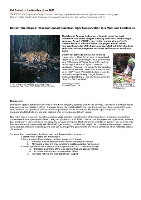
Cat Project of the Month – June 2008<br />
The IUCN/SSC Cat Specialist Group's website (www.catsg.org) presents each month a different cat conservation project.<br />
Members of the Cat Specialist Group are encouraged to submit a short description of <strong>in</strong>terest<strong>in</strong>g projects<br />
Repa<strong>in</strong>t the Stripes: <strong>Research</strong>-<strong>based</strong> <strong>Sumatran</strong> <strong>Tiger</strong> <strong>Conservation</strong> <strong>in</strong> a <strong>Multi</strong>-<strong>use</strong> Landscape<br />
A tiger strides on an <strong>in</strong>undated peat swamp forest <strong>in</strong><br />
Kerumutan, Riau (Photo WWF_PHKA_VATech/Sunarto).<br />
The island of Sumatra, Indonesia, is home to one of the most<br />
threatened subspecies of tigers surviv<strong>in</strong>g <strong>in</strong> the wild: Panthera tigris<br />
sumatrae. As part of WWF’s <strong>in</strong>tervention and my Virg<strong>in</strong>ia Tech’s<br />
Student <strong>Research</strong> <strong>in</strong> Riau Prov<strong>in</strong>ce, this project aims to deliver<br />
improved knowledge of the tiger’s ecology, which will <strong>in</strong>form land <strong>use</strong><br />
and conservation management decisions, and improved security for<br />
tigers.<br />
Sunarto has started to focus on cat study and<br />
conservation <strong>in</strong> 2004. At that time, he jo<strong>in</strong>ed WWF<br />
Indonesia as a wildlife biologist. He is also enrolled<br />
as a PhD student at Virg<strong>in</strong>ia Tech, USA, study<strong>in</strong>g<br />
the ecology of <strong>Sumatran</strong> tigers <strong>in</strong> the Riau<br />
Landscape. Previously, he worked for <strong>Conservation</strong><br />
International, Wildlife <strong>Conservation</strong> Society as well<br />
as an ICDP Project. With WCS, he lead a team to<br />
build and manage the Way Canguk <strong>Research</strong><br />
Station <strong>in</strong> BBS National Park. Sunarto is a member<br />
of the Cat SG s<strong>in</strong>ce 2008.<br />
s.sunarto@yahoo.com<br />
submitted: March 2008<br />
Sett<strong>in</strong>g up a camera trap <strong>in</strong><br />
the Tesso Nilo forest (Photo<br />
WWF/Sunarto).<br />
Background<br />
Numbers of tigers <strong>in</strong> Sumatra are believed to have been constantly decl<strong>in</strong><strong>in</strong>g over the last decades. The decl<strong>in</strong>e is ow<strong>in</strong>g to habitat<br />
loss, poach<strong>in</strong>g, and retaliation kill<strong>in</strong>gs. <strong>Sumatran</strong> forests, the ma<strong>in</strong> habitat for the tiger, have cont<strong>in</strong>ually been converted to largescale<br />
<strong>in</strong>dustrial and agricultural plantations; ma<strong>in</strong>ly grow oil palm and acacia trees. Meanwhile, tigers are poached for the<br />
<strong>in</strong>ternational wildlife trade and are often captured after com<strong>in</strong>g <strong>in</strong>to conflict with people.<br />
Riau is the largest prov<strong>in</strong>ce <strong>in</strong> Sumatra which potentially holds the highest number of <strong>Sumatran</strong> tigers. It conta<strong>in</strong>s several <strong>Tiger</strong><br />
<strong>Conservation</strong> Landscapes under different categories (Sanderson et al. 2006). Until the time this project was implemented, however,<br />
tiger distribution <strong>in</strong> the area has not been properly surveyed or mapped. Most <strong>in</strong>formation available on tigers <strong>in</strong> Riau stemmed only<br />
from secondary sources generally associated with tiger poach<strong>in</strong>g or conflict with people. Accurate <strong>in</strong>formation on tiger presence<br />
and distribution <strong>in</strong> Riau is critical to guid<strong>in</strong>g land-<strong>use</strong> plann<strong>in</strong>g by the governments and private companies which hold large estates<br />
of forestland.<br />
To secure tiger populations <strong>in</strong> the Landscape, the follow<strong>in</strong>g actions are required:<br />
1. Identification of areas still hold<strong>in</strong>g tigers<br />
2. Secur<strong>in</strong>g current tiger and prey numbers <strong>in</strong> core areas through<br />
a. Protected area establishment and effective management thereof<br />
b. Monitor<strong>in</strong>g of tiger and prey numbers to facilitate adaptive management<br />
3. Landscape conservation to ensure habitat preservation and connectivity through<br />
a. Increased awareness of the local communities and decision makers<br />
b. Increased effectiveness of enforcement efforts<br />
c. Increased national and local stakeholder support
Staff capacity build<strong>in</strong>g <strong>in</strong> field research<br />
data management (Photo Sunarto).<br />
My project foc<strong>use</strong>s on:<br />
1. Identify<strong>in</strong>g areas still hold<strong>in</strong>g tigers, estimate the density <strong>in</strong><br />
major habitats, and predict the probability of occurrence<br />
across the landscape.<br />
2. Dissem<strong>in</strong>at<strong>in</strong>g research f<strong>in</strong>d<strong>in</strong>gs for habitat protection,<br />
management and restoration, <strong>in</strong>clud<strong>in</strong>g the development of<br />
new protected areas and improved management of tiger<br />
habitats.<br />
3. Build<strong>in</strong>g local capacity on tiger conservation.<br />
Methods<br />
To reveal the ecological characteristics of tigers <strong>in</strong> the landscape we <strong>use</strong>d a variety of field techniques which <strong>in</strong>clude <strong>in</strong>terviews and<br />
ad-hoc surveys to document tiger presence, camera trapp<strong>in</strong>g for abundance estimation, and detection-non detection/occupancy<br />
estimation to predict the occurrence of tigers.<br />
Identify<strong>in</strong>g areas still hold<strong>in</strong>g tigers<br />
Identification of tiger presence <strong>in</strong> the landscape <strong>in</strong>volved stages of activities. First, potential habitats for tigers are identified, ma<strong>in</strong>ly<br />
<strong>based</strong> on the land cover. We considered the rema<strong>in</strong><strong>in</strong>g forest as the potential habitat. Areas of large forest patches are the target<br />
area where tiger presence is to be confirmed. We <strong>use</strong>d different approaches <strong>in</strong> gather<strong>in</strong>g <strong>in</strong>formation on tiger presence which<br />
<strong>in</strong>clude <strong>in</strong>terview<strong>in</strong>g authorities and local people, direct survey for tiger sign, as well as camera trapp<strong>in</strong>g and other systematic<br />
sampl<strong>in</strong>gs such as occupancy survey.<br />
Map of The Tesso Nilo-Bukit Tigapuluh <strong>Conservation</strong> Landscape <strong>in</strong> Southern Riau Prov<strong>in</strong>ce,<br />
Sumatra.<br />
Estimat<strong>in</strong>g the abundance of tigers us<strong>in</strong>g<br />
camera traps<br />
We found that <strong>in</strong> our study area camera traps<br />
are only effective for <strong>use</strong> <strong>in</strong> forested areas.<br />
This was due to high human activities and<br />
low probability to capture wildlife <strong>in</strong> areas<br />
outside of forests. We placed 13 equallyspaced<br />
possible camera trap sampl<strong>in</strong>g<br />
blocks, each measur<strong>in</strong>g ca. 128 km 2 <strong>in</strong> the<br />
ca. 17,000 km 2 forests <strong>in</strong> the Tesso Nilo-Bukit<br />
Tigapuluh <strong>Conservation</strong> Landscape (see<br />
map).<br />
To beg<strong>in</strong> with, we selected 4 sampl<strong>in</strong>g<br />
blocks, represent<strong>in</strong>g 3 major habitat types <strong>in</strong><br />
the landscape, to be covered <strong>in</strong> the first two<br />
year. We covered each sampl<strong>in</strong>g blocks with<br />
+/- 40 camera traps placed <strong>in</strong> pairs <strong>in</strong> about<br />
20 sites. Photographic data generated from<br />
camera trapp<strong>in</strong>g were ma<strong>in</strong>ly <strong>use</strong>d to<br />
estimate the density of naturally marked<br />
animals such as the tiger, us<strong>in</strong>g capturemark-recapture<br />
techniques. For animals<br />
which have no natural mark<strong>in</strong>g <strong>in</strong>dividually,<br />
we estimate the relative abundance <strong>based</strong> on<br />
the photographic capture rates.<br />
To estimate the relative abundance of tigers<br />
and their prey outside of forest habitat, we<br />
<strong>use</strong>d another technique such as the<br />
detection-non detection or occupancy survey
Estimat<strong>in</strong>g site occupancy to predict the probability of occurrence for tigers and their prey<br />
We conducted this survey as part of a larger <strong>in</strong>itiative to study the tiger and other large mammals <strong>in</strong> Sumatra. For that, we have<br />
adjusted our sampl<strong>in</strong>g techniques to comply with the common method. We agreed to <strong>use</strong> a common grid size of 17x17 km. We<br />
designed the sampl<strong>in</strong>g technique <strong>in</strong> such a way that we will be able to analyze the result<strong>in</strong>g data for both habitat <strong>use</strong> and<br />
occupancy estimations. For the first year of implement<strong>in</strong>g this technique, we selected 20 (twenty) 17x17 km grids us<strong>in</strong>g stratified<br />
random sampl<strong>in</strong>g. WWF (Setiabudi and Budiman 2005) has classified the landscape accord<strong>in</strong>g to the landcover types which we<br />
<strong>use</strong>d to stratify the sampl<strong>in</strong>g. The number of 17x17 grids selected was proportionate to the area represented by the respective<br />
land cover type <strong>in</strong> the landscape.<br />
We aimed to set for 40 ‘transects’ <strong>in</strong> each of 17x17 km grid. In each grid, observations were conducted <strong>in</strong> segmented transects.<br />
Each ‘transect’ (1000 meter) was divided <strong>in</strong>to ten segments of 100 meter each. Data collection for signs of target animals and<br />
environmental variables was conducted at every segment.<br />
We plan to analyze the data at two levels. At the island-wide level, we will comb<strong>in</strong>e our data with other parties. For the island or<br />
larger landscape level, we will treat the 17x17 grid as the ‘site’, while each 1 km transect as a sampl<strong>in</strong>g occasion. At the smaller<br />
area level, we will treat each 1 km transect as the ‘site’ and the 100 meter segments as ‘occasions’. The larger scale analysis is<br />
expected to reveal the ‘true occupancy’ for tigers, while smaller scale can be both tiger’s ‘habitat <strong>use</strong>’ and ‘true occupancy’ for<br />
smaller animals.<br />
Kusdianto and Harry, tiger research team do<strong>in</strong>g the occupancy survey (Photo Sunarto).<br />
To m<strong>in</strong>imize potential bias, we randomly<br />
selected a 2x2 km cell with<strong>in</strong> each 17x17km<br />
grid for each team to <strong>in</strong>clude <strong>in</strong> their route of<br />
observation transects. If there is more than<br />
one team cover<strong>in</strong>g the same 17x17 km grids<br />
we selected a random cell for each team. To<br />
beg<strong>in</strong> a new transect a random direction with a<br />
distance of 200 meter from the latest position<br />
(e.g. dropp<strong>in</strong>g po<strong>in</strong>t) or previous transect, was<br />
selected. Although the transect started at a<br />
random po<strong>in</strong>t, the team surveyed areas<br />
deemed to have the highest likelihood of<br />
f<strong>in</strong>d<strong>in</strong>g animal’s sign. We <strong>in</strong>tensively searched<br />
for tiger and prey sign <strong>in</strong> areas where we are<br />
most likely to detect such sign, such as on<br />
forest trails, sand beds, and river banks.<br />
Dissem<strong>in</strong>at<strong>in</strong>g research f<strong>in</strong>d<strong>in</strong>gs for habitat protection and management<br />
We <strong>use</strong>d the research f<strong>in</strong>d<strong>in</strong>gs to promote the species conservation through better policy, improved awareness, as well as<br />
habitat protection and management. To make sure the policy, we supported the development of national conservation strategy<br />
and action plan for the tiger. We also advocated the development of human-tiger conflict mitigation protocols. In the<br />
development of both documents, our hands-on experiences are <strong>use</strong>d to enrich the document.<br />
Based on the <strong>in</strong>formation on tiger presence, we promoted the<br />
development, expansion as well as better management of the<br />
protected areas. For example, we promoted the expansion of Bukit<br />
Tigapuluh National Park and Tesso Nilo National Park to make sure<br />
long-term viability of the tiger which otherwise will have no adequate<br />
habitat or population to thrive over long-term.<br />
To promote better practices of the private sectors, particularly those<br />
who manage lands <strong>in</strong> the around tiger habitat, we have designed our<br />
research and will <strong>use</strong> the results as a base to develop a guidel<strong>in</strong>e to<br />
improve the management practices to be more friendly and<br />
supportive to tiger conservation.<br />
We supported the Government led develop-<br />
ment of conservation strategy for <strong>Sumatran</strong><br />
tiger (Photo Sunarto).
Cobar Hutajulu_local MS student sett<strong>in</strong>g up a camera trap (Photo Sunarto).<br />
Results<br />
Camera Trapp<strong>in</strong>g: Abundance estimation<br />
We have systematically sampled us<strong>in</strong>g camera<br />
traps, up to June 2007, not less than 86 sites located<br />
<strong>in</strong> 4 sampl<strong>in</strong>g blocks that represent 3 major habitat<br />
types <strong>in</strong> the landscape. Around 25 percent of the<br />
sites, located <strong>in</strong> Tesso Nilo National Park, were<br />
sampled twice, which will enable temporal<br />
comparison as a means of biodiversity monitor<strong>in</strong>g.<br />
Until early 2007, up to which field data were already<br />
properly compiled, we accumulated 13,400 camera<br />
trap nights, covered 2,123 km2 of effective sampl<strong>in</strong>g<br />
area, and obta<strong>in</strong>ed 58 <strong>in</strong>dependent tiger pictures.<br />
We photographed 10 <strong>in</strong>dividual tigers under CMR<br />
protocols, plus 4 <strong>in</strong>dividuals dur<strong>in</strong>g ad hoc camera<br />
trapp<strong>in</strong>gs. These results constitute the first<br />
scientifically <strong>based</strong> evidence of tiger presence <strong>in</strong> 4<br />
key forest blocks <strong>in</strong> Southern Riau. Undeniable<br />
evidence of tiger presence serves as an important<br />
tool for advocacy to prevent this habitat from be<strong>in</strong>g<br />
converted.<br />
Build<strong>in</strong>g local capacity on tiger conservation<br />
The project aims to build local capacity on tiger<br />
conser- vation, specifically <strong>in</strong> conducted scientific<br />
research, as an <strong>in</strong>tegral part the program’s strategy.<br />
The capacity build<strong>in</strong>g program <strong>in</strong>cludes the support of<br />
the project for the team member to pursue higher<br />
education at a PhD level (Sunarto, Virg<strong>in</strong>ia Teach)<br />
and an MS Student (Maju B. Hutajulu, University of<br />
Indonesia). In addition, we also created an<br />
assistantship scheme for local students to conduct<br />
various research related to tiger conservation. We<br />
are now f<strong>in</strong>ancially support<strong>in</strong>g 10 local students from<br />
various higher educational <strong>in</strong>stitutions to conduct<br />
research on tiger-related issues. The students will<br />
<strong>use</strong> the research as their f<strong>in</strong>al thesis. Furthermore, to<br />
promote <strong>in</strong>volvement of local students, we also<br />
promote the <strong>in</strong>volvement of those who are <strong>in</strong>terested<br />
<strong>in</strong> jo<strong>in</strong><strong>in</strong>g our field activities as volunteers. Currently<br />
we have two local students <strong>in</strong>volved as volunteers<br />
who jo<strong>in</strong> <strong>in</strong> the field surveys.<br />
The first n<strong>in</strong>e <strong>in</strong>dividuals of tigers photographed <strong>in</strong> the Landscape (Photo WWF- PHKA-<br />
VT/Sunarto).<br />
Based on our limited sample, hav<strong>in</strong>g considered the effective sampl<strong>in</strong>g areas, we documented that the highest density of adult<br />
tigers (<strong>in</strong>dividuals/100 km2) was estimated from KRWR (wet flat forests, 1.27 to 5.5), followed by RBWR (hilly forests, 0.92 to<br />
4.03), and TNNP (dry flat forests, 0.64 to 1.4). When we <strong>use</strong>d a different approach of estimat<strong>in</strong>g density <strong>based</strong> on the capture<br />
rate (Relative Abundance Index, O’Brien et al. 2003), however, the results were not consistent. With this approach, TNNP was<br />
ranked highest with estimate density of 1.392 <strong>in</strong>dividual per 100 km2, followed by KRWR (0.055), and RBWR (0.001). The<br />
estimates are not robust, hence we considered this provisional. More samples will probably overcome this constra<strong>in</strong>t.
An <strong>in</strong>dustrial plantation grows acacia trees adjacent to a tiger reserve: we are<br />
work<strong>in</strong>g to promote better management practices so that tigers will have wider<br />
space <strong>in</strong> which to roam (Photo Sunarto).<br />
References<br />
<strong>Tiger</strong> Distribution Mapp<strong>in</strong>g<br />
All forest blocks <strong>in</strong> TNBTCL provide habitat for tigers. We<br />
recorded tiger presence <strong>in</strong> the four major forest blocks, each of<br />
which measured at least 100,000 ha. We produced a map of<br />
the landscape show<strong>in</strong>g the different probability that tigers occur<br />
<strong>in</strong> a given po<strong>in</strong>t. From the map, we identified six major areas<br />
with high probability of tiger occurrence <strong>in</strong> Southern Riau.<br />
Those <strong>in</strong>clude Bukit Bungkuk, Rimbang Bal<strong>in</strong>g, Tesso Nilo,<br />
Bukit Tigapuluh, Kerumutan, and Kampar Pen<strong>in</strong>sula. What’s<br />
strik<strong>in</strong>g from the result of this exercise is the fact that many<br />
areas important for tiger conservation are not protected. In<br />
addition to a good management of the protected areas, more<br />
<strong>in</strong>tensive works to promote the protection of those areas are<br />
central <strong>in</strong> the long-term conservation of the tigers <strong>in</strong> the<br />
landscape.<br />
Promot<strong>in</strong>g Private Sectors’ Better Management Practices<br />
(BMP)<br />
We are <strong>in</strong> the process of develop<strong>in</strong>g BMP guidel<strong>in</strong>es that will<br />
be <strong>use</strong>d by timber and palm oil plantations to promote tiger<br />
conservation.<br />
O'Brien, T. G., M. F. K<strong>in</strong>naird, and H. T. Wibisono. 2003. Crouch<strong>in</strong>g tigers, hidden prey: <strong>Sumatran</strong> tiger and prey populations <strong>in</strong><br />
a tropical forest landscape. Animal <strong>Conservation</strong> 2003 131–139.<br />
Sanderson, E., J. Forrest, C. Loucks, J. G<strong>in</strong>sberg, E. D<strong>in</strong>erste<strong>in</strong>, J. Seidensticker, P. Leimgruber, M. Songer, A. Heydlauff, T.<br />
O’Brien, G. Bryja, S. Klenzendorf, and E. Wikramanayake. 2006. Sett<strong>in</strong>g Priorities for the <strong>Conservation</strong> and Recovery of<br />
Wild <strong>Tiger</strong>s: 2005-2015. WCS, WWF, Smithsonian, and NFWF-STF.<br />
Setiabudi, A. Budiman, and M. Stuewe. 2005. Analysis of 2000-2004 Land Use Dynamics <strong>in</strong> the Tesso Nilo - Bukit Tiga Puluh<br />
<strong>Conservation</strong> Landscape, Riau, Sumatra. Yayasan WWF.<br />
Project Information<br />
Duration: December 2004 – ongo<strong>in</strong>g<br />
Location (see map): Sothern Riau Landscape, Sumatra<br />
Sponsor(s): STF/NFWF, USFWS, Hurvis Family, WWF Network<br />
Project address: WWF Indonesia - Riau Program<br />
<strong>Tiger</strong> <strong>Research</strong> Unit<br />
Komplex Perkantoran Grand Sudirman, Blok B-1<br />
Jl. Datuk Setia Maharaja, Pekanbaru - Riau Indonesia 28282<br />
Phone : (0761) 855006, Fax : (0761) 35323a<br />
Project leader: Scientific Advisors:<br />
Dr. Sybille Klenzendorf, Director of Species <strong>Conservation</strong>, WWF-US<br />
Dr. Marcella Kelly, Assistant Professor, Virg<strong>in</strong>ia Tech<br />
Programatic Advisors:<br />
Dr. Hadi S. Alikodra, Director of Species <strong>Conservation</strong>, WWF Indonesia<br />
Dudi Rufendi, Manager, Riau <strong>Conservation</strong> Program, WWF Indonesia<br />
<strong>Research</strong> Coord<strong>in</strong>ator<br />
Sunarto, Survey and Monitor<strong>in</strong>g Coord<strong>in</strong>ator, WWF Indonesia & PhD Student, Virg<strong>in</strong>ia<br />
Tech<br />
Email: s.sunarto@yahoo.co<br />
Project website www.wwf.or.id/tessonilo