Guidebook
Guidebook
Guidebook

You also want an ePaper? Increase the reach of your titles
YUMPU automatically turns print PDFs into web optimized ePapers that Google loves.
Volume n° 2 - from B16 to B33<br />
B16<br />
B16 -<br />
Leaders: R. Bourrouilh, L. Moen-Maurel, J. Muñoz, A. Teixell<br />
Field Itinerary<br />
DAY 1<br />
Pau<br />
Welcome to the fi eld trip and the Pyrenees<br />
By R. Bourrouilh, L. Moen-Maurel, J. Muñoz And<br />
A. Teixell.<br />
Briefi ng and introduction to the Field Trip.<br />
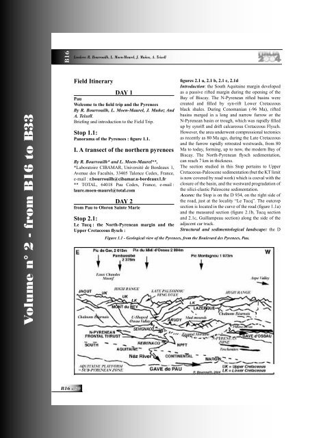
Stop 1.1:<br />
Panorama of the Pyrenees : fi gure 1.1.<br />
I. A transect of the northern pyrenees<br />
By R. Bourrouilh* and L. Moen-Maurel**,<br />
*Laboratoire CIBAMAR, Université de Bordeaux 1,<br />
Avenue des Facultés, 33405 Talence Cedex, France,<br />
e-mail : r.bourrouilh@cibamar.u-bordeaux1.fr<br />
** TOTAL, 64018 Pau Cedex, France, e-mail :<br />
laure.moen-maurel@total.com<br />
DAY 2<br />
from Pau to Oloron Sainte Marie<br />
Stop 2.1:<br />
Le Tucq : the North-Pyrenean margin and the<br />
Upper Cretaceous fl ysch :<br />
fi gures 2.1 a, 2.1 b, 2.1 c, 2.1d<br />
Introduction: the South Aquitaine margin developed<br />
as a passive rifted margin during the opening of the<br />
Bay of Biscay. The N-Pyrenean rifted basins were<br />
created and fi lled by syn-rift Lower Cretaceous<br />
black shales. During Cenomanian (-96 Ma), rifted<br />
basins merged in a long and narrow furrow or the<br />
N-Pyrenean basin or trough, which was rapidly fi lled<br />
up by synrift and drift calcareous Cretaceous Flysch.<br />
However, the area underwent compressional tectonics<br />
as recently as 80 Ma ago, during the Late Cretaceous<br />
and the furrow rapidly retreated westwards, from 80<br />
Ma to today, forming, up to now, the modern Bay of<br />
Biscay. The North-Pyrenean fl ysch sedimentation,<br />
can reach 7 km in thickness.<br />
The section studied in this Stop pertains to Upper<br />
Cretaceous-Paleocene sedimentation (but the KT limit<br />
is now covered by road work) which is coeval with the<br />
closure of the basin, and the westward progradation of<br />
the silici-clastic Paleocene sedimentation.<br />
Access: the Stop is on the D 934, on the right side of<br />
the road, just at the locality “Le Tucq”. The outcrop<br />
section is located in the curve of the road (fi gure 1.1a)<br />
and the measured section (fi gure 2.1b, Tucq section<br />
and 2.1c, Guillampeau section) along the side of the<br />
adjacent car track.<br />
Structural and sedimentological landscape: the D<br />
Figure 1.1 - Geological view of the Pyrenees, from the Boulevard des Pyrenees, Pau.