Guidebook
Guidebook
Guidebook

Create successful ePaper yourself
Turn your PDF publications into a flip-book with our unique Google optimized e-Paper software.
Volume n° 2 - from B16 to B33<br />
B16<br />
B16 -<br />
Leaders: R. Bourrouilh, L. Moen-Maurel, J. Muñoz, A. Teixell<br />
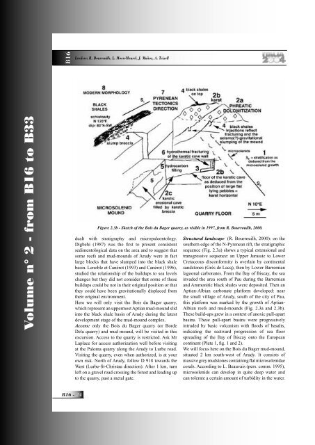
Figure 2.3b - Sketch of the Bois du Bager quarry, as visible in 1997, from R. Bourrouilh, 2000.<br />
dealt with stratigraphy and micropaleontology.<br />
Digbehi (1987) was the fi rst to present consistent<br />
sedimentological data on the area and to suggest that<br />
some reefs and mud-mounds of Arudy were in fact<br />
large blocks that have slumped into the black shale<br />
basin. Lenoble et Canérot (1993) and Canérot (1996),<br />
studied the relationship of the buildups to sea levels<br />
changes but they did not consider that some of these<br />
buildups could be not in their original position or that<br />
they could have been gravitationally displaced from<br />
their original environment.<br />
Here we will only visit the Bois du Bager quarry,<br />
which represent an uppermost Aptian mud-mound slid<br />
into the black shale basin of Arudy during the latest<br />
development stage of the mud-mound complex.<br />
Access: only the Bois du Bager quarry (or Borde<br />
Dela quarry) and mud mound, will be visited in this<br />
excursion. Access to the quarry is restricted. Ask Mr<br />
Laplace for access authorization well before visiting<br />
at the Paloma quarry along the Arudy to Lurbe road.<br />
Visiting the quarry, even when authorized, is at your<br />
own risk. North of Arudy, follow D 918 towards the<br />
West (Lurbe-St-Christau direction). After 1 km, turn<br />
left on a gravel road crossing the forest and leading up<br />
to the quarry, past a metal gate.<br />
Structural landscape (R. Bourrouilh, 2000): on the<br />
southern edge of the N-Pyrenean rift, the stratigraphic<br />
sequence (Fig. 2.3a) shows a typical extensional and<br />
transgressive sequence: an Upper Jurassic to Lower<br />
Cretaceous disconformity is overlain by continental<br />
sandstones (Grès de Lacq), then by Lower Barremian<br />
lagoonal carbonates. From the Bay of Biscay, the sea<br />
invaded the area south of Pau during the Barremian<br />
and Ammonitic black shales were deposited. Then an<br />
Aptian-Albian carbonate platform developed: near<br />
the small village of Arudy, south of the city of Pau,<br />
this platform was marked by the growth of Aptian-<br />
Albian reefs and mud-mounds (Fig. 2.3a and 2.3b).<br />
These build-ups grew in a context of anoxic pull-apart<br />
basins. These pull-apart basins were progressively<br />
intruded by basic volcanism with fl oods of basalts,<br />
indicating the eastward progression of sea fl oor<br />
spreading of the Bay of Biscay onto the European<br />
continent (Plate 1, fi g. 1 and 2).<br />
We will focus here on the Bois du Bager mud-mound,<br />
situated 2 km south-west of Arudy. It consists of<br />
massive grey mudstones containing fl at microsolenidae<br />
corals. According to L. Beauvais (pers. comm. 1995),<br />
microsolenids can develop in quite deep water and<br />
can tolerate a certain amount of turbidity in the water.