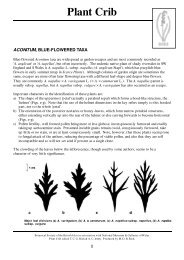
East Perthshire - Botanical Society of the British Isles
East Perthshire - Botanical Society of the British Isles
East Perthshire - Botanical Society of the British Isles

Create successful ePaper yourself
Turn your PDF publications into a flip-book with our unique Google optimized e-Paper software.
2 ACKNOWLEDGEMENTS<br />
Thanks are due to Jim McIntosh, Scottish Officer <strong>of</strong> <strong>the</strong> BSBI, for his help in too<br />
many ways to mention but in particular for his detailed comments on <strong>the</strong> first draft<br />
and for his help with <strong>the</strong> production <strong>of</strong> <strong>the</strong> Register. Bob Ellis also helped with <strong>the</strong><br />
production. The Register is a compilation <strong>of</strong> records that have been made by many<br />
recorders, be <strong>the</strong>y members <strong>of</strong> <strong>the</strong> BSBI, Perth <strong>Society</strong> <strong>of</strong> Natural Science, SNH staff<br />
or contractors, or visiting botanists, and thanks are due to all. David McCosh went to<br />
considerable trouble over ensuring that <strong>the</strong> Hieracium section was correct and Bert<br />
Reid supplied <strong>the</strong> relevant section <strong>of</strong> <strong>the</strong> national Taraxacum database. Helen Taylor<br />
(SNH) allowed use <strong>of</strong> <strong>the</strong> data from <strong>the</strong> 2010 survey <strong>of</strong> Juniper in <strong>Perthshire</strong>. Certain<br />
people have greatly enhanced <strong>the</strong> Recorder’s knowledge <strong>of</strong> plants in <strong>the</strong> Vicecounty,<br />
prime among whom are Leslie Tucker (willows) and Nick Stewart (water<br />
plants). Margaret Bradshaw enabled us to record <strong>the</strong> genus Alchemilla more<br />
accurately. Andy Scobie and Theo Loizou kindly supplied datasets in response to<br />
<strong>the</strong> first edition. Finally thanks are due to <strong>the</strong> many landowners, tenants, keepers and<br />
o<strong>the</strong>rs who have welcomed botanists on to <strong>the</strong>ir ground.<br />
3 WATSONIAN VICE-COUNTIES<br />
These date from 1852, when <strong>the</strong>y were set up “to provide a set <strong>of</strong> unit areas more<br />
equal in <strong>the</strong>ir dimensions than <strong>the</strong> counties, ‘whose extreme inequality <strong>of</strong> size was<br />
most inconvenient and objectionable’ ”(Dandy, 1969). The system has long been<br />
adopted as standard for biological recording in this country. An important feature is<br />
that <strong>the</strong> boundaries are constant, not changing with <strong>the</strong> political whims <strong>of</strong> succeeding<br />
generations. Most <strong>of</strong> <strong>East</strong> Perth lies within what was originally <strong>Perthshire</strong> and is now<br />
Perth & Kinross, with political changes only affecting parts <strong>of</strong> <strong>the</strong> eastern boundary.<br />
The sou<strong>the</strong>rn boundary is <strong>the</strong> Firth <strong>of</strong> Tay, <strong>the</strong> western boundary is <strong>the</strong> Tay –<br />
Tummel – Garry river system, and <strong>the</strong> nor<strong>the</strong>rn boundary abuts on Inverness-shire<br />
and Aberdeenshire following Grampian watersheds. The eastern boundary,<br />
however, follows older lines in some areas: a bulge to <strong>the</strong> east includes Fowlis and<br />
Piper Dam, but to <strong>the</strong> north <strong>of</strong> this <strong>the</strong> Vice-county <strong>of</strong> Angus bulges westwards into<br />
Perth & Kinross to include a block around Gaskhill, Lintrose, Hallyburton and Kettins.<br />
There is ano<strong>the</strong>r, smaller deviation from <strong>the</strong> modern political boundary to <strong>the</strong> north <strong>of</strong><br />
<strong>the</strong> Forest <strong>of</strong> Alyth around Blacklunans.<br />
4 PLANT RECORDING IN EAST PERTH<br />
Records since 1970 only are included. In that year a decision was made by <strong>the</strong><br />
<strong>Botanical</strong> section <strong>of</strong> <strong>the</strong> <strong>Perthshire</strong> <strong>Society</strong> <strong>of</strong> Natural Science to record plants on a<br />
5x5 km (quadrant) basis with a view to eventually producing a new Flora <strong>of</strong><br />
<strong>Perthshire</strong>. In 2006 this system was altered and tetrad (2x2 km) recording began.<br />
The change was made in order to comply with accepted biological recording methods<br />
over <strong>the</strong> wider UK and especially with practice that had been adopted by <strong>the</strong> BSBI<br />
nationwide. Prior to this <strong>the</strong> perception had been that it would be impracticable to<br />
cover <strong>Perthshire</strong> fully on a 2x2 km square basis, as <strong>the</strong>re are too many remote areas<br />
and too few botanists. This remains <strong>the</strong> case and no complete tetrad map <strong>of</strong> every<br />
species will ever be produced in a reasonable time-scale. Even an incomplete tetrad<br />
map, however, conveys more useful information on habitat use and distribution than<br />
a complete quadrant one.<br />
As far as possible, using knowledge <strong>of</strong> routes and sites, records on <strong>the</strong> quadrant<br />
recording cards have been reallocated to tetrads. The two systems are not entirely<br />
compatible, however, as <strong>the</strong>re are 9 tetrads in each 10x10 km square (hectad) which<br />
3