Gambia Niumi National Park RIS 2008 E - Wetlands International
Gambia Niumi National Park RIS 2008 E - Wetlands International
Gambia Niumi National Park RIS 2008 E - Wetlands International

Create successful ePaper yourself
Turn your PDF publications into a flip-book with our unique Google optimized e-Paper software.
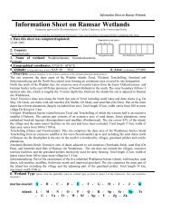
Information Sheet on Ramsar <strong>Wetlands</strong> (<strong>RIS</strong>)<br />
– 2006-<strong>2008</strong> version<br />
Available for download from http://www.ramsar.org/ris/key_ris_index.htm.<br />
Categories approved by Recommendation 4.7 (1990), as amended by Resolution VIII.13 of the 8 th Conference of the Contracting Parties<br />
(2002) and Resolutions IX.1 Annex B, IX.6, IX.21 and IX. 22 of the 9 th Conference of the Contracting Parties (2005).<br />
Notes for compilers:<br />
1. The <strong>RIS</strong> should be completed in accordance with the attached Explanatory Notes and Guidelines for<br />
completing the Information Sheet on Ramsar <strong>Wetlands</strong>. Compilers are strongly advised to read this guidance<br />
before filling in the <strong>RIS</strong>.<br />
2. Further information and guidance in support of Ramsar site designations are provided in the Strategic<br />
Framework and guidelines for the future development of the List of <strong>Wetlands</strong> of <strong>International</strong> Importance (Ramsar<br />
Wise Use Handbook 7, 2 nd edition, as amended by COP9 Resolution IX.1 Annex B). A 3 rd edition of<br />
the Handbook, incorporating these amendments, is in preparation and will be available in 2006.<br />
3. Once completed, the <strong>RIS</strong> (and accompanying map(s)) should be submitted to the Ramsar Secretariat.<br />
Compilers should provide an electronic (MS Word) copy of the <strong>RIS</strong> and, where possible, digital copies<br />
of all maps.<br />
1. Name and address of the compiler of this form:<br />
Ousainou TOURAY (email: oustouray@gmail.com;<br />
wildlife@gamtel.gm), Alagie Manjang<br />
(alagie33@hotmail.com) and<br />
ICAM Project c/o Department of <strong>Park</strong>s and Wildlife<br />
Management (DPWM), Abuko Headquarters<br />
Abuko Nature Reserve,<br />
The <strong>Gambia</strong>.<br />
2. Date this sheet was completed/updated:<br />
10 th October, <strong>2008</strong><br />
3. Country:<br />
The <strong>Gambia</strong><br />
4. Name of the Ramsar site:<br />
<strong>Niumi</strong> <strong>National</strong> <strong>Park</strong><br />
5. Designation of new Ramsar site or update of existing site:<br />
This <strong>RIS</strong> is for (tick one box only):<br />
a) Designation of a new Ramsar site ; or<br />
b) Updated information on an existing Ramsar site <br />
FOR OFFICE USE ONLY.<br />
DD MM YY<br />
Designation date Site Reference Number
6. For <strong>RIS</strong> updates only, changes to the site since its designation or earlier update:<br />
a) Site boundary and area<br />
The Ramsar site boundary and site area are unchanged: <br />
or<br />
If the site boundary has changed:<br />
i) the boundary has been delineated more accurately ; or<br />
ii) the boundary has been extended ; or<br />
iii) the boundary has been restricted** <br />
and/or<br />
If the site area has changed:<br />
i) the area has been measured more accurately ; or<br />
ii) the area has been extended ; or<br />
iii) the area has been reduced** <br />
b) Describe briefly any major changes to the ecological character of the Ramsar site, including in the<br />
application of the Criteria, since the previous <strong>RIS</strong> for the site:<br />
7. Map of site:<br />
Refer to Annex III of the Explanatory Note and Guidelines, for detailed guidance on provision of suitable maps, including digital maps.<br />
a) A map of the site, with clearly delineated boundaries, is included as:<br />
i) a hard copy (required for inclusion of site in the Ramsar List) NB: As a print out of digital map: ;<br />
ii) an electronic format (e.g. a JPEG or ArcView image) ;<br />
iii) a GIS file providing geo-referenced site boundary vectors and attribute tables .<br />
b) Describe briefly the type of boundary delineation applied:<br />
<strong>Niumi</strong> <strong>National</strong> <strong>Park</strong> – This <strong>Park</strong> occupies the coastal strip north of the river <strong>Gambia</strong> The<br />
<strong>Park</strong> is bordered by Barra, Essau, Mayamba, Medina Kanuma and Kanuma in the south; on the<br />
East by Mbollet ba and Mbankam villages; on the northern side we have the village of Bakindik<br />
and the Delta Du Saloum <strong>National</strong> <strong>Park</strong> of Senegal (the Northern limit of the Ramsar site is the<br />
border between <strong>Gambia</strong> and Senegal.). On the western front is the Atlantic Ocean.The<br />
boundary of the proposed Ramsar site is the same as the boundary of the <strong>National</strong> <strong>Park</strong>.<br />
8. Geographical coordinates (latitude/longitude, in degrees and minutes):<br />
Central coordinates: 13°34'N 16°31'W<br />
9. General location:<br />
<strong>Niumi</strong> <strong>National</strong> <strong>Park</strong> occupies the coastal strip of the north bank of the river <strong>Gambia</strong>. <strong>Niumi</strong><br />
extends to the Senegalese border where it joins with the Delta du Saloum <strong>National</strong> <strong>Park</strong>. <strong>Niumi</strong><br />
essentially form the southern limit of the vast delta complex which is centered on the seasonal<br />
sine and Saloum Rivers. The site is located in the North Bank Region and especially in the<br />
Lower <strong>Niumi</strong> District/ It is located within easy access to Banjul city with a distance of 7 nautical<br />
miles and stretching all the way to the border of Senegal at Hamdallayi
10. Elevation: (in metres: average and/or maximum & minimum)<br />
The average elevation within the park is
The Jinack Island included in the <strong>Park</strong> has some narrow, sandy beaches facing the Atlantic,<br />
backed by sand-dunes, a coastal lagoon, seasonally wet salt marshes, narrow Rhizophora<br />
mangrove, mud flats and rice fields. The main land section of the <strong>Park</strong> has more extensive tall<br />
Rhizophora mangrove forest, small areas of salt marsh and mudflats. The Atlantic coast is<br />
notable for nationally high numbers of Sterna dougallii and, probably, several breeding pairs of<br />
the locally declining Charadrius marginatus. The tidal creeks, saltmarshes and rice-fields have<br />
generally low numbers of waterbirds, but Limosa limosa occasionally occurs in thousands (Paul<br />
Robinson, 2001).<br />
The mangrove ecosystem is considered as vulnerable, it covers 600 ha in NNP. NNP is a<br />
continuum of Delta du Saloum Biosphere Reserve where it is found that more than 70 species<br />
of fish either reproduce or nurse in the mangrove. The swamp and the mudflats shelters more<br />
than 200 species of birds, crustaceans and planktons. The avifaunal diversity is remarkable,<br />
with total of 293 species from 63 families that have been recorded from <strong>Niumi</strong> <strong>National</strong> <strong>Park</strong> to<br />
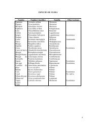
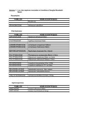
date. See annex 3 for more details on avifaunal diversity in NNP.<br />
The gallery forest in NNP shelters diverse fauna such as monkey: patas (Erythrocebus patas),<br />
green (Cercopithecus aethiops) and Gallago (Galago galago), hyenas (Crocuta crocuta), bucks<br />
(Antilope cervicapra), warthogs (Phacochoerus aethiopicus), etc.<br />
<strong>Niumi</strong> <strong>National</strong> <strong>Park</strong> has currently 293 species listed from 63 families, 88 breed in the Palearctic.<br />
(AFRICAN WATERFOWL CENSUS REPORTS 1997, 1998, 1999, 2000. T.Dodman, Cor de Vaan,<br />
Edith Hubert and Claire Nivet) Published by <strong>Wetlands</strong> <strong>International</strong>, Wageningen, The<br />
Netherlands.)<br />
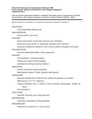
See Annex 1 for the list of birds found in <strong>Niumi</strong> <strong>National</strong> <strong>Park</strong>.<br />
Criterion 4:<br />
Many terrestrial and aquatic species spend a part of their life cycle in NNP.<br />
Palearctic birds spend winter time in NNP and Delta du Saloum <strong>National</strong> <strong>Park</strong> mudflats. The<br />
health of these mudflats is critical for wintering birds, since their reproduction in Siberia and<br />
North Europe and Canada depends on the fattening stage during winter season.<br />
Research in Delta du Saloum have shown that more than 70 species of fish either spawn or<br />
nurse in the mangrove, In particular, shrimps species such as Paneaus notialis recruit in the<br />
mangrove ecosystem of the Saloum, <strong>Gambia</strong> and Casamance Rivers. NNP is crosses the two<br />
first cited rivers.<br />
The sand beach of NNP is identified by DPWM and University of Exeter (UK) as nesting site for<br />
green turtles in 2006 survey<br />
Large numbers of herons, egrets and terns regularly fly through the site into roosts in the Delta<br />
du Saloum <strong>National</strong> <strong>Park</strong> in Senegal<br />
The sand beach is special place for green turtle (Chelonia mydas) nest.<br />
Criterion 6:<br />
The site is known to hold, on a regular basis, ≥ 1% of the biogeographic population of the<br />
Sandwich Tern (Sterna sandvicensis). Other congregatory waterbird species such as Slenderbilled<br />
Gull (Larus genei), Caspian Tern (Sterna caspia), and Royal Tern (Sterna maxima) are<br />
also supported by the resources from the site, however the supported population is just under<br />
the 1% threshold. They nevertheless contribute to the overall biodiversity of the biogeographic<br />
region (BirdLife <strong>International</strong> <strong>2008</strong>).
Criterion 7:<br />
The species observed and those reported to occur in the area were quite similar to those found<br />
at Tanbi Wetland Complex. Nonetheless, it should be mentioned that the amount of fry of the<br />
Great Africa threadfin (Polydactylus quadrifilis) seen here surpassed those found at any of the<br />
other sites sampled. Provided below is a list of the families of species observed and those<br />
reported to occur in the area.<br />
Families of Fish<br />
Families Mangrove Lagoons Seasonally Coastal<br />
Flooded Areas Strip<br />
Cichlidae X X X<br />
Clupeidae X X X<br />
Carangidae X X<br />
Drepanidae X X<br />
Elopidae X X X<br />
Gerreidae X X X X<br />
Lutjanidae X X<br />
Mugilidae X X X X<br />
Polynemidae X X<br />
Pomadasyidae X X X<br />
Sciaenidae X X<br />
Sparidae X X<br />
Tetraodontidae X X<br />
Aquatic Invertebrate:<br />
Crustaceans: Shrimps were not observed in the invertebrate fauna during field assessments. It<br />
was however reported that they were in the area. Few individuals of gladiator swim crabs,<br />
(Callinectes pallidus) were observed in some of the lagoons near the Niji bolong. Numerous<br />
West African fiddler crabs were seen inhabiting in burrows near the water bodies at the creeks<br />
and lagoons. Many African ghost crabs, (Ocypode Africana) were observed at the coastal strip.<br />
Molluscs:<br />
The presence of dense vegetation of mangrove trees around the creeks may easily permit<br />
habitation by mangrove oysters, (Grassostera tulipa). It was reported that in the past large<br />
quantities of mangrove oysters were harvested around Kajata village for commercial purposes<br />
by the villagers. Other molluscs observed were whelks present in the mud near the water<br />
bodies in large amounts.<br />
Criterion 8:<br />
During the survey the species that were physically encountered belong to the families of the<br />
Cichlidae, Clupeidae, Gerreidae, Mugilidae, Pomadasyidae and Polynemidae. Apart from the<br />
few tilapia adults seen, all the other fishes were found in their early development stages, mostly<br />
as fry and juveniles. Scoop net trials in water bodies at the Niji bolong captured shads (<br />
Ethmalosa fimbriata ) fry measuring an average length of 12 .0mm and Great Africa threadfins<br />
of 3.4cm (total length). Numerous fry and juveniles of mullets (Mugil cephalus), tilapia, Giant<br />
Africa threadfins (Polydactylus quadrifilis), shads and flagfin mojarra occur at the creeks and<br />
lagoons with salinities of 45.0% and below. Lagoons and ponds within the seasonally flooded
areas with salinities of 40.0-45.0% had low fish densities. Most of them were tilapia and<br />
mullets. Water bodies which recorded higher salinity levels did not have fish occurring in them.<br />
Many of the species that are known to be littoral at maturity were found at the mangrove<br />
creeks, lagoon and ponds near the creeks. The smallest fry were found in ponds where the<br />
depth was shallowest.<br />
15. Biogeography (required when Criteria 1 and/or 3 and /or certain applications of Criterion 2 are applied<br />
to the designation):<br />
Name the relevant biogeographic region that includes the Ramsar site, and identify the biogeographic regionalisation system that has<br />
been applied.<br />
a) biogeographic region:<br />
The site falls under the Senegal-<strong>Gambia</strong> Catchments Fresh water eco-region of the<br />
“Savanna-Dry Forest Rivers” bioregion. This is a tropical and subtropical eco-region<br />
in which rivers flow through landscapes dominated by grasslands, sometimes<br />
interspersed with tall shrubs and tress in an open formation.<br />
Senegal-<strong>Gambia</strong> Catchments Freshwater Eco-region<br />
b) biogeographic regionalisation scheme (include reference citation): WWF Freshwater Ecoregions of<br />
Africa and Madagascar<br />
16. Physical features of the site:<br />
Geology<br />
<strong>Niumi</strong> <strong>National</strong> <strong>Park</strong> occupies the southern portion of the Sine – Saloum Delta and has a surface<br />
geology greatly influenced by the formation of a Ritz (drowned river valley within the Njii<br />
Bolong during the Noukachottian (7,000 to 3,650 YBP) (Whyte and Russel 1988). During this<br />
transgression sea level rose 3-4 m flooding much of what is now <strong>Niumi</strong> <strong>National</strong> <strong>Park</strong> resulting<br />
in sequences of unconsolidated sand silts and clay. Beaches and sand berms were<br />
subsequently left perched 4m above the existing high water mark, though have subsequently<br />
been eroded and re-worked. The sand deposits of the oceanic coast are referred to as the<br />
coastal Beach complex (IBID). The continental Terminal Series abuts onto this complex at<br />
<strong>Niumi</strong> with occasional exposure of laterite boulders as in the escarpment east to the Marsarinko<br />
Bolon. The Nouakchottian shoreline is evident along the Keur Sanyang Bolong where it forms<br />
low eroding cliffs. Jinack island and the mosaic of islands to the north which form the sine –<br />
Saloum delta are essentially shifting shoals of sand which have stabilized through colonization<br />
by vegetation by vegetation though still maintain a degree of dynamism evident in the erosion –<br />
deposition occurring at the channel mouths e.g. Buniada point.<br />
Soils<br />
A detailed soil survey was conducted in the vicinity of Kajata and Niji on Jinack Island as part of<br />
the programme to rehabilitate rice fields which have been subject to saltwater intrusion over<br />
the last decade. The survey area was confined to two broad physiographic units the elevated<br />
sand dune complexes and the low – lying flood plain area. The sand dune complexes are<br />
composed of relatively young underdeveloped coarse textured soils that are low in nutrients<br />
and available water. The soil is unsuitable for most crops with the exception of coconuts. The<br />
low lying flood plain is loaded with sodium salts, though the soils are moderately drained and<br />
contain appreciable amounts of nutrients. The problem of excessive sodium could be overcome<br />
if sufficient water is available to leach it out (SWMU 1990).<br />
Hydrology
The bolongs or creeks/tributaries of <strong>Niumi</strong> <strong>National</strong> <strong>Park</strong> are subject to the daily rhythm of the<br />
tides which have a maximum range of 2.0m on equinoxal springs. The freshwater input into<br />
the Kerr Sanyang and Sanchi Bolongs is negligible over the dry season. During the rains from<br />
May/June to October, the salinity of the bolongs decreases in the upper reaches. The low lying<br />
areas on Jinack island and on the mainland flood during the rains creating generally linear<br />
ponds and seasonal marshes in the salt pans and tamarisk scrub. The degree of flooding is a<br />
function of the extent of the rainfall, and in low – rainfall years flooding may be limited to relict<br />
bolons. Flooded areas gradually recede as the dry season sets in and salinity of the water<br />
increases through evaporation.<br />
The ground water table on the island of Jinack fluctuates between 3 and 5m depending on the<br />
season. The complexity of the aquifer in the area has not been thoroughly investigated, but in<br />
places freshwater is present at 3 to 4m depth less than 100m from the shoreline.<br />
Climate<br />
The <strong>Gambia</strong> is in the intertropical and its climate is generally described as Sudano-Sahalian.<br />
Rainfall concentrates between the months of June to October with a country average of 850mm<br />
per annum (Report of the ANR Working Group, 1996). The rainfall is generally less in the<br />
northern half of the country and greatest in the southwest. There has been a 25-30% decrease<br />
in annual average rainfall over the period 1950 to 1990s (Ibid).<br />
17. Physical features of the catchment area:<br />
Describe the surface area, general geology and geomorphological features, general soil types, and climate (including climate type).<br />
<strong>Niumi</strong> <strong>National</strong> <strong>Park</strong> has two main creek systems running through it. The Niji bolong connects<br />
to the ocean immediately north of Barra point and to the Mansarinko Bolong at the Senegalese<br />
border thereby forming the island of Jinack. This bolong is subject to the regular diurnal tidal<br />
cycle and as it has a small catchment area there is relatively little seasonal variation in salinity.<br />
The Mansarinko bolong divides north of Mbankam to form the Keur Jatta and Duniajoe bolongs.<br />
These bolongs have a combined catchment in the region of 100 km 2 and resultantly have a<br />
marked seasonal variation in salinity. During the dry season hyper – saline conditions exist in<br />
the upper reaches due to limited tidal flushing and high evaporation rates. As the rains<br />
commence dilution occurs and the salinity levels reduces progressively. The associated<br />
vegetation with these bolongs is predominantly mangrove where there is a gentle gradient on<br />
the banks. Elsewhere, the vegetation ranges from woodland to grassland. There appears to be<br />
no associated aquatic vegetation within the bolongs with the exception of the mangrove<br />
complex.<br />
18. Hydrological values:<br />
Describe the functions and values of the wetland in groundwater recharge, flood control, sediment trapping, shoreline stabilization,<br />
etc.<br />
The hydrological values of the wetland are one of the major reasons to classify NNP as a<br />
Ramsar site. The hydrological values are explained in section 14. They include<br />
• flood control,<br />
• groundwater replenishment,<br />
• shoreline stabilization,<br />
• sediment and nutrient retention and export,<br />
The bolongs or creeks of <strong>Niumi</strong> <strong>National</strong> <strong>Park</strong> are subject to the daily rhythm of the tides, which<br />
have a maximum range of 2m on equinoxal springs. The freshwater input into the Keur Saniang
and Sanchi Bolongs is negligible over the dry season. During the rains from May/June to<br />
October/November, the salinity of the bolongs decreases in the upper reaches. Low-lying areas<br />
on Jinack Island and on the mainland flood during the rains creating generally linear ponds and<br />
seasonal marshes in the salt pans and Tamarisk, Tamarix senegalensis scrub. The degree of<br />
flooding is a function of the extent of the rainfall, and in low-rainfall years flooding may be<br />
limited to relict bolongs. Flooded areas gradually recede as the dry season sets in and salinity of<br />
the water increases through evaporation (Ramsar Wetland Study The <strong>Gambia</strong>, 1997).<br />
19. Wetland Types<br />
a) Presence:<br />
Circle or underline the applicable codes for the wetland types of the Ramsar “Classification System for Wetland Type” present in the<br />
Ramsar site. Descriptions of each wetland type code are provided in Annex I of the Explanatory Notes & Guidelines.<br />
Marine/coastal: A • B • C • D • E • F • G • H • I • J • K • Zk(a)<br />
Inland: L • M • N • O • P • Q • R • Sp • Ss • Tp Ts • U • Va •<br />
Vt • W • Xf • Xp • Y • Zg • Zk(b)<br />
Human-made: 1 • 2 • 3 • 4 • 5 • 6 • 7 • 8 • 9 • Zk(c)<br />
b) dominance: .<br />
Mangrove forest (Type I) is predominant within <strong>Niumi</strong> <strong>National</strong> <strong>Park</strong> and is found along the<br />
Mansarinko and Niji Bolongs. The north – east tip of Jinack Island and the Mbankam spit have<br />
extensive stands of this forest type which is backed by scrub forest and bare tannes. Stands of<br />
riverine mangrove forest are found in the mid and upper tidal reaches of the Mansarinko<br />
Bolong, reaching heights up to 12m though generally less than 10m. On the spits opposite and<br />
to the south of Bakindik Koto, this forest type occurs on a peat deposit which sporadically in the<br />
<strong>Gambia</strong> as thin beds within the fluvial marine sequence (White and Russell, 1988).<br />
The season saline flats (Type R) which are found within <strong>Niumi</strong> <strong>National</strong> <strong>Park</strong>s are distributed<br />
primarily on the landward side of the mangrove belt.<br />
Areas peripheral to and often part of the saline flats and backing the mangrove forest in places<br />
develop as seasonal saline marshes (Type Ss) with a combination of halophytic species and<br />
various cyperaceous. As the dry season commences these areas undergo progressive<br />
desiccation and the vegetation cover dies back.<br />
The head waters of the various bolons both large and small support seasonal fresh water<br />
marshes (Type Ts). As the dry season advances most of these areas desiccate entirely or<br />
undergo an increase in salinity through evaporation and saline intrusion. Between Barra Point<br />
and Buniada Point the coastal profile is a gently shelving sand embayment with a predominantly<br />
northerly current.<br />
The Mansarinko bolong is the main water body within the <strong>Niumi</strong> <strong>National</strong> <strong>Park</strong> and rises as two<br />
streams c1km inland. The freshwater flow (Type F) on these bolongs is negligible during the<br />
dry season and they are brackish to saline through out the year. The habitat associated with<br />
these water bodies includes mangrove forest; inter tidal mudflats and salt marsh. In their<br />
upper reaches freshwater pools persist into the dry season but ultimately dry completely.<br />
The upper reaches of Keur Jatta and Duniajoe bolons have seasonal freshwater follow (Type N).<br />
There are a number of other small bolons both on the island of Jinack and on the mainland<br />
which are rain fed but due to small catchment areas are more prone to rapid salinisation<br />
through a combination of evaporation and intrusion<br />
The northern tip of Jinack Island forms the estuary for a number of bolongs with seasonal<br />
freshwater flow. The bolongs are tidal for their entire dry season length and resultantly have<br />
extensive fringes of halophytic vegetation. The combined tidal outflow of these bolongs
meeting the northerly currents arising from the river <strong>Gambia</strong> have resulted in a sand bar<br />
formation (Type G) of Buniada Point.<br />
The sand shoreline (Type E) between Barra and Buniada and the single coastal lagoon (Type J)<br />
occurring at Buniada Point on the north Shore of Jinack Island (occupying an area of ca 2ha)<br />
are the less dominant habitats in this national park . Finally there are very insignificant and<br />
temporal small spots of brackish seasonal lagoons occurring in the area.<br />
Inter Tidal Marshes (Type H): Halophytic vegetation associated with salt pans has been<br />
referred to above and the same complex of species is also association with inter tidal marshes<br />
and seasonally flooded areas. On the island of Jinack the low lying nature of the island<br />
(essentially a vegetation spit) subjects a large portion of the island to seasonal flooding through<br />
rainfall. The salinity of these areas steadily rises due to residual salts and evaporation following<br />
the end of the rains and the dominant vegetation is essentially halophytic in nature. Rainfall<br />
swamps occur on the eastern side of the island and are utilized for rice cultivation. Parts of the<br />
seasonally flooded areas are also subject to periodic flooding during spring tides. Salt marshes<br />
are generally fringed by Tamarix senegalensis with occasional Avicennia Africana, Adansonia<br />
digitata occurs on slightly elevated land fringing the marshes.<br />
Permanent Shallow Marine Waters (Type A): Between Barra Point and Buniada Point the coastal<br />
profile is a gently shelving sand embayment with a predominantly northerly current. The depth<br />
of water at high tide is in the region of 5 meters up to 2km offshore. There is considerable<br />
movement of sediments in the vicinity of Buniada Point where sand bars extend up to 2km to<br />
the west. Much of this sand deposition is the result of erosion further south along the shoreline<br />
of Jinack Island. Anecdotal information suggests that the beach in front of Madiyana Camp has<br />
been eroded by around 15m in the last two years. There appears to be little subtidal vegetation<br />
though the occasional presence of eel grass cymodocea nodosa along the shoreline which<br />
suggests there may be beds within the confines of the park.<br />
• Intertidal forests, Mangrove forests (type I)<br />
• Seasonal saline Flats (type R)<br />
• Seasonal saline marshes (Ss)<br />
• Seasonal freshwater marshes (Ts)<br />
• Estuarine waters (type F)<br />
• Seasonal rivers (type N)<br />
• Intertidal sand and mud flats (type G)<br />
• Sand Shores (type E)<br />
• Coastal lagoons (type J)<br />
• Brackish lagoons (type J)<br />
• Seasonal freshwater marshes (type H)<br />
• Seasonally wet salt marshes (type H)<br />
• Permanent shallow marine waters (Type A)<br />
20. General ecological features:<br />
Provide further description, as appropriate, of the main habitats, vegetation types, plant and animal communities present in the<br />
Ramsar site, and the ecosystem services of the site and the benefits derived from them.<br />
The vegetation of <strong>Niumi</strong> <strong>National</strong> <strong>Park</strong> has to a greater or lesser degree been modified through<br />
anthropogenic factors, resulting today in a combination of derived and early successional<br />
vegetation types. The degree of modification varies according to the vegetation type and the<br />
proximity to settlement. On the mainland, extensive clearing for agriculture has followed a<br />
shifting pattern in the past with areas left to fallow allowing subsequent regeneration.<br />
Generally such areas are not cleared of the larger trees and this act as mother trees for natural
eseeding. The incidence of fire is also most prevalent on the mainland which kills young trees<br />
while scarring and weakening mature specimens. Utilization of the mangrove has been on<br />
limited scale in the past probably due to the preference for other timbers in construction,<br />
fencing, fuel wood requirements etc. The following major vegetation types can be<br />
distinguished.<br />
Major Habitat/ Vegetation Types<br />
Marine and Coastal<br />
• Permanent Shallow Marine Waters<br />
• Sand Shores<br />
• Estuarine Waters<br />
• Inter Tidal Sand and Mud Flats<br />
• Inter Tidal Marshes<br />
• Inter Tidal Forests<br />
• Coastal Lagoons<br />
Inland <strong>Wetlands</strong><br />
• Permanent Creeks<br />
• Seasonal Creeks<br />
• Seasonal Saline Flats<br />
• Seasonal Saline Marshes<br />
• Seasonal Freshwater Marshes<br />
• Gallery Forest<br />
• Dry Woodland and Wooded Grassland<br />
See annex 2 for further details on habitat and vegetation types<br />
Habitat Types and associated biodiversity<br />
A wide variety of faunal species are found in association with the various wetland habitat types<br />
within <strong>Niumi</strong> <strong>National</strong> <strong>Park</strong>. There is considerable overlap in the habitat utilized by any given<br />
species in general, though some species are more confined by their adaptation to either a<br />
freshwater or saline environment. One of the values of <strong>Niumi</strong> lies in the variety of habitat types<br />
found in close proximity which results in a rich array of ecotones (see section on fauna-habitat<br />
association).<br />
The greatest variation in biodiversity is found within the avifauna, which is composed of both<br />
resident and inter-African and Palearctic Migratory African species occur with many species<br />
utilizing the wetland areas for breeding and feeding purpose. In the early autumn the<br />
Palearctic migration gets underway and a large diversity and abundance of species accumulate<br />
in the wetlands of <strong>Niumi</strong>. Many of these birds will stop off to build up fat reserve after their<br />
migration before dispersing further into the continent. <strong>Niumi</strong> acts as one of the main staging<br />
post on the Palearctic migration, being located as it is at the mouth of the River <strong>Gambia</strong>. The<br />
river is apparently use as a corridor to the inland areas of the continent as well as providing<br />
extensive wintering grounds for many species. By the time the spring migration north<br />
commences, much of the <strong>Niumi</strong> wetlands have dried and its feeding value for waders and<br />
waterfowl is reduced. Nonetheless, it still holds valuable feeding and roosting for gulls, tens<br />
and certain wader species.
The waterways of <strong>Niumi</strong> are home to one of the region’s rarer aquatic mammals: the West<br />
Africa manatee (Trichechus senegalensis). The manatee until recently was still persecuted<br />
within the park area and remains shy and elusive, though evidently present from recent local<br />
reports. The Atlantic humpbacked dolphin (Sousa teuszii ) also utilizes the <strong>Niumi</strong> waterways<br />
and coastal waters. Crocodiles (Crocodilus niloticus ) are resident within all of the permanent<br />
water bodies and some of the more secluded seasonal bolongs. In the latter areas, they<br />
occupy burrows over the period the bolong is dry which may be up to 6 months.<br />
21. Noteworthy flora:<br />
Provide additional information on particular species and why they are noteworthy (expanding as necessary on information provided in<br />
14, Justification for the application of the Criteria) indicating, e.g., which species/communities are unique, rare, endangered or<br />
biogeographically important, etc. Do not include here taxonomic lists of species present – these may be supplied as supplementary information to the<br />
<strong>RIS</strong>.<br />
The only available note worthy flora is attached as annex 2 of this document.<br />
22. Noteworthy fauna:<br />
Provide additional information on particular species and why they are noteworthy (expanding as necessary on information provided in<br />
12. Justification for the application of the Criteria) indicating, e.g., which species/communities are unique, rare, endangered or<br />
biogeographically important, etc., including count data. Do not include here taxonomic lists of species present – these may be supplied as<br />
supplementary information to the <strong>RIS</strong>.<br />
Avifauna<br />
<strong>Niumi</strong> <strong>National</strong> <strong>Park</strong> has currently 293 species listed from 63 families, 88 breed in the Palearctic.<br />
The park is contiguous with sine- Saloum <strong>National</strong> <strong>Park</strong> in Senegal, and is centered around and<br />
inclusive of the coastal island f Jinack. Jinack contains a number of local communities which<br />
are all looking for new Jinack initiatives to generate economic activity. The present state is one<br />
of a locally depressed agricultural predicament. The island is divided from the Tanbi Wetland<br />
complex on the south bank with which it is intrinsically linked, by the estuary of the River<br />
<strong>Gambia</strong>.<br />
Resident and migrant waterfowl<br />
Rhizophora mangrove<br />
The northern aspect of the park is demarcated by a labyrinth of Rhizophora mangrove creeks<br />
and channels that are presently not well researched in seasonal terms. At low tide in January<br />
extensive mud flats are exposed harboring a divers range of feeding shorebirds that reflect the<br />
avifaunal content of the Bund Road area (Tanbi Wetland Complex) African Fish Eagle (<br />
Haliaetus vocifer) and Goliath Heron (Ardea goliath) are commonly seen but not numerous.<br />
Ble-cheeked Bee Eater (Merops persicus) are particularly abundant also in January. The creek<br />
systems are used by a variety of kingfisher species both resident and regionally migrant.<br />
Shoreline Shorebirds and Seabirds<br />
The uninterrupted c 15 km shoreline of Jinack islands is a highway for constant streams of<br />
migrating flocks of turnstone (Arenaria interpres) and Sanderling (Calidris alba) in February-<br />
March. Grey plovers use the littoral to forage. Solitary and small group of palm – nut Vulture (<br />
Gypohierax angolensis) scavenge dead fish and good numbers of Osprey (Pandion haliaetus) sit<br />
directly on the sand to rest or eat prey during the movement north in February – early March<br />
(14 on 3km of beach March 1995 pers. Obs). Osprey is present in all months at this site.<br />
Observations over the last decade suggests an increase of dry season Oystercatcher (<br />
Haematopus ostralegus) in The <strong>Gambia</strong> around <strong>Niumi</strong> increasingly bigger flocks are seen from<br />
Banjul crossing the estuary. Important stands of mixed gulls and terns accumulate at the
undisturbed northern tip of the island (e.g 500 Royal Terns (Sterna maxima) January 1994), it<br />
is proposed that increased observation time at this under-watched site would likely reveal<br />
Audouin’s Gull (Larus audouini) and possibly Roseate Tern (Sterna dougallii). The first record<br />
for Arctic Tern (S. paradisaea) for over a decade was collected here in October 1994 in the<br />
same week that the species was found at Tanji Bird Reserve on the south coast (pers.obs).<br />
The only modern <strong>Gambia</strong>n coastal record for African skimmer (Rynchops flavirostris) is here<br />
also in September 1995 (pers.obs.). Large numbers of lesser-blacked Backed Gulls (Larus<br />
fuscus) assemble throughout the dry season.<br />
Seasonal Pond and Streams<br />
In years of heavy rain the island becomes centrally flooded with streams feeding out to the<br />
beach and creeks, while in years of poor rain it remain largely dry and crops fail. When<br />
inundated, these sites become rapidly colonised by African jacana (Actophilornis africana) and<br />
Greater Painted Snipe (Rostratula benghalensis ) and when they recede and dry out after the<br />
wet-season much benefit is gleaned by foraging passage waders e.g 800 Black – tailed Godwit<br />
(Limosa limosa) feeding in a dried our field in February 95. Considerable areas remain flooded<br />
at least into February and provide feeding for a variety for waders.<br />
Congregations of herons and egret species arrive to harvest stranded fish and Four-Banded<br />
Sandegrouse (Pterocles quadricintus) come at dusk to drink until it completely dries up. When<br />
flooded a diversity of ploceidae weavers and bishops, Sylvinae cisticolas and prinias Timaliinae<br />
babblers and Estrildidae waxbills breed in the damp rank vegetation. Didric cuckoo (<br />
Chrysococcyx caprius), Levaillant cuckoo (Clamator levaillantii) pin-tailed whydah (Vidua<br />
macroura) and village indigobird (vidua chalybeate ) are all present seeking suitable hosts for<br />
their parasitic breeding habits and offer research potential.<br />
Coastal Scrub and Palearctic Migrants<br />
The mixed coastal scrub around the island is profuse in palearctic warbler life. A diversity of<br />
small palearctic insectivores, some on a brief loop type migratory passage e.g Garden Warbler<br />
(sylvia boring) exploit swampy Tamarisk and Andropegon to forage September-December. A<br />
number of other e.g Olivaceous, Melodious and sub-alpine warbler (Hippolais pallida, H.<br />
Polyglotta, Sylvia cantillans) are known to be more sedentary and use the abundant Acacia and<br />
ficus trees throuthout their wintering stay. Earlier thoughts on strong southern Mediterranean<br />
links e.g spain, between palearctic breeding birds and The <strong>Gambia</strong> are evidenced by the results<br />
of the <strong>Niumi</strong> ringing project. This was a small ringing project which was in operation for three<br />
seasons (1995-7) and was manned by visitors from October-April. A total of 34 palearctic<br />
passerine species have been handled up to April 1996. So far mistnetting has produced two<br />
species for The <strong>Gambia</strong> i.e Lesser Whitethroat (sylvia curruca) and European Scops owl (Otus<br />
scops).<br />
Mammals<br />
The mammalian fauna of The <strong>Gambia</strong> has been considerably depleted over the last century and<br />
few large mammals could be described as abundant with the exception of the warthog<br />
(phacochoerus aethiopicus) the vervet or green monkey (Cercopithecus aethiops) and the patas<br />
monkey (Erythrocebus patas)<br />
Aquatic Mammal Diversity<br />
West African Manatee:<br />
The manatee (Trichechus senegalensis) is found in both Senegal and The <strong>Gambia</strong> inhabiting<br />
both coastal waters, rivers and lakes (Haltenorth and Diller 1980). It is tolerant of both salt and<br />
freshwater with a temperature range of 25-35ºC. Being herbivorous, it is dependent on an<br />
ample supply of aquatic plants or riverside vegetation. Within <strong>Niumi</strong> it appears to feed on
mangrove (Rhizophora spp) primarily and possibly moves offshore to feed on the seagrass beds<br />
( Cymodocea nodosa). Being primarily nocturnal where it is subject to disturbance, it is difficult<br />
to gauge its abundance but to considerable hunting pressures up until quite recently it appears<br />
to have declined to a critically low level. Hunting was conducted by the construction a<br />
midwater platform from which foraging manages were harpooned. The meant of the manatee<br />
is apparently very palatable and their hide is used in the making of “calosht” (baton of herding<br />
or protection).<br />
There may be movement between the River <strong>Gambia</strong> and the Delta du Saloum but no details are<br />
known. There have anecdotal reports by fishermen of sightings several kilometers offshore.<br />
Humpback Dolphin:<br />
The humpback dolphin (Sousa teuzii) occurs along the West African coast from Mauritania<br />
southward occupying estuaries and coastal waters. The dolphin is known to utilize the inshore<br />
waters also on the coastal strip of <strong>Niumi</strong> and presumably moves into the bolongs also (dolphins<br />
have been reported in the Mansarinko and Niji bolongs though sufficient details to permit<br />
identification were not available). Within the Delta du Saloum numerous sightings have been<br />
made of this species well within the delta complex (Mairetg 1980). The estuary of the River<br />
<strong>Gambia</strong> especially the area around Dog Island (15 Km) south east of Barr point) is frequented<br />
by the humpback dolphin but it shares its range with the more widespread bottle-nosed dolphin<br />
(Tursiops truncatus) which is found up to 100km upriver.<br />
There appears to be some seasonality to the movement of the humpback dolphin as few<br />
sightings have been made over the period from January to May. During October to December<br />
numerous sightings of dolphins were reported off Jinack Island with schools of up to 40<br />
humpbacks seen (Paul Murphy). The dolphins are not actively persecuted though animals<br />
incidentally taken in fishing nets are generally consumed.<br />
Clawless Otter:<br />
The clawless otter (Aonyx capensis) has a virtual pan – African distribution south of the Sahara<br />
but appears to be no where common. It is thinly distributed throughout The <strong>Gambia</strong> and is<br />
considered to be nationally rare. Clawless otters are reported to be present within <strong>Niumi</strong><br />
<strong>National</strong> <strong>Park</strong>s (DPWM files) though no evidence of the species was noted during the current<br />
survey. Given its general nocturnal activity and its ability to range over both terrestrial and<br />
aquatic habitats it is most probable that they still occur.<br />
Terrestrial Mammal Diversity<br />
Ungulates:<br />
Both the oribi (Ourebia ourebi) and the bohor reedbuck (Redunca redunca) are reported to<br />
have been present within the <strong>Niumi</strong> <strong>National</strong> <strong>Park</strong>s in recent times (DPWM files) but no<br />
indications of the presence of either species was found during the current survey or in<br />
communication with local residents. The oribi and bohor reedbuck are founds within the Delta<br />
du Saloum <strong>National</strong> <strong>Park</strong>s and individuals may move into <strong>Niumi</strong> occasionally.<br />
The bushbuck (Tragelaphus scriptus) is found throughout the parks where there is suitable<br />
cover but appears to be very secretive due to human disturbance. They appear to be most<br />
abundant on the island of Jinack and their tracks have been seen on the shoreline on a number<br />
of occasions.<br />
Of the three species of duiker recorded from The <strong>Gambia</strong>, both Maxwell’s (Cephalophus<br />
monticola/maxwellii) and the common or grey duiker (sylvicapra grimmia) occur within <strong>Niumi</strong>.<br />
Owing to their shy behaviour and preference for dense thickets it is difficult to gauge their<br />
abundance but they appear to be widespread.
The warthog (phacochoerus aethiopicus), commonly referred to as the ‘bushpig’ within The<br />
<strong>Gambia</strong> is present within <strong>Niumi</strong> in apparently low numbers. This species appears to be more<br />
abundant in the Delta du Saloum <strong>National</strong> <strong>Park</strong>s and there is presumably some movement<br />
between the two parks. Owing to their depredations on agricultural crops, the warthog is listed<br />
under schedule IV of the wildlife Act (1997) as a vermin species and a licence is not required to<br />
hunt them. However all wildlife are given full protection within the protected areas of The<br />
<strong>Gambia</strong> and therefore the species should not be subject to persecution in <strong>Niumi</strong>. The relevant<br />
abundance of the warthog within The <strong>Gambia</strong> is probably a result of the dominance of Islam<br />
among <strong>Gambia</strong>ns.<br />
Carnivores:<br />
The leopard (Panthera pardus) has been recorded from Jinack island on a number of occasions<br />
in recent years and undoubtedly a small number of animals utilise the park as part of their<br />
range. Their extreme secretiveness and stealth allow them to go undetected, though an<br />
individual was sighted during day light hours in 1996 on the island of jinack. Again, the<br />
proximity of the Delta du Saloum <strong>National</strong> <strong>Park</strong>s has probably enabled this feline to maintain a<br />
hold within <strong>Niumi</strong> as surplus animals migrate out of their parental territory.<br />
The caracal (Felis caracal), the serval (Felis serval) and the Africa wildcat (Felis Sylvesters) are<br />
known to occur within <strong>Niumi</strong> though it is difficult to determine their abundance. The western<br />
golden cat (Profelis aurata) may also be present but no records currently exist. The small cats<br />
have ample prey in the form of rodents and ground birds such as francolin (Francolinus<br />
bicalcaratus) and sand grouse (Pterocles quadricinctus). They are however, known to be<br />
prosecuted as evidenced by an incident in 1996 when a serval was captured and eaten on the<br />
island of Jinack.<br />
The spotted hyena (Crocuta crocuta) is widespread within <strong>Niumi</strong> and its tracks are frequently<br />
seen. They appear to be generally solitary-presumably owing to the limited availability of prey<br />
and carrion but maintain contact through vocalishing. Individuals have been observed foraging<br />
along the coastal strip for dead fish etc.<br />
Other carnivores known to occur within he marsh mongoose (Herpestes paludinosus). The<br />
Egyptian mongoose (H.ichneumo). The slender mongoose (H.sanguineus), the banded<br />
mongoose (Mungos mungo), the <strong>Gambia</strong>n mongoose (M.gambianus) and possibly the<br />
cusimanse (Crossarchus obscurus). The abundance of these smaller carnivores is currently not<br />
known.<br />
Primates:<br />
The red colobus (Colobus badius temmincki )is found in the denser woodland and remnant<br />
gallery forest areas and also sometimes utilizes the mangrove as a corridor or for roosting The<br />
patas (Erythrocebus patas) is common within the park and is probably the most abundant<br />
primate due to its preference for open Savannah. Troops of up to 45 patas have been in the<br />
open grassed woodland west of Mbollet Bah. Vervet monkeys (Cercopithecus aethiops) are also<br />
widespread and appear to utilize the mangrove in the same way as the colobus.<br />
The bushbaby or lesser galago (Galago senegalensis) is known to occur and is probably quite<br />
common though difficult to observe due to its nocturnal habits and arboreal habits. Baboons (<br />
Papio cynocephalus anubis) appear to use the parks only on a temporary basis, presumably<br />
moving between the Delta du Saloum to the north of the <strong>Niumi</strong> national park. No resident<br />
troop have identified within <strong>Niumi</strong> <strong>National</strong> <strong>Park</strong>s.<br />
Other mammals
Crawshay’s hare (Lepus crawshayi) is widely distributed within <strong>Niumi</strong>, as are the striped groundsquirrel<br />
(Euxerus erythropus) and the sun-squirrel (Heliosciurus gambians), the cane-cutter rat<br />
(Thryonomys swinderianus), the spring hare (Pedetes capensis) and the porcupine (Hystrix<br />
cristate). Smaller rodents are not well known, but include gerbils (Gerbilidae) and mice<br />
(Muridae). The hedgehog (Erinaceus albiventris) is most probably present and possibly also the<br />
aardvark (orycteropus afer).<br />
The bat’s (Chiroptera) of <strong>Niumi</strong> <strong>National</strong> park have not being studied to date, though the<br />
following species have been recorded; the <strong>Gambia</strong>n epauletted bat ( Epomophorus gambianus),<br />
the <strong>Gambia</strong>n slit-faced bat (Nycteris gambianus), other species present within the park.<br />
23. Social and cultural values:<br />
a) Describe if the site has any general social and/or cultural values e.g., fisheries production, forestry,<br />
religious importance, archaeological sites, social relations with the wetland, etc. Distinguish between<br />
historical/archaeological/religious significance and current socio-economic values:<br />
Current Socio-Economic Activities<br />
Agriculture<br />
The main agricultural activity within the wetland area is rice cultivation, which is conducted<br />
through out the reserve much of the current cultivation techniques are extensive in nature and<br />
there is some degree of rotation in sites used on an annual basis.<br />
Fishing<br />
Despite the good fishing grounds within the bolongs and in the inshore waters, fishing activities<br />
are primarily at the subsistence level within <strong>Niumi</strong> <strong>National</strong> <strong>Park</strong>. A few individuals from each of<br />
the villages close to the bolongs are involved in gill netting on a part-time basis and fish traps<br />
are also utilized on the upper bolongs towards the end of the rains as the waters are subsiding.<br />
The catches are generally home consumed or bartered at the village level for other goods or<br />
services. On the Senegalese end of Jinack Island, the villages of Barra and Diatoko are more<br />
commercially oriented in their fishing activity which reaches the market of the larger towns.<br />
Women are engaged in the harvesting of oysters clams and whelks in the Mansarinko and Niji<br />
Bolongs. The oysters are cut from the prop roots of mangroves, and the latter are gathered<br />
from sandbanks during spring tides. Again these activities are primarily at subsistence level<br />
though that is not to underscore their importance in the local economy and in nutrition.<br />
Timber and Building Materials<br />
The mangrove timber is valued for its resistance to insect damage and it is used primarily for<br />
cross-timbers and lath’s in roofing. As the amount of timber available in the dry woodland<br />
diminishes through over-exploitation and excessive use of fire, it is being turned to more and<br />
more for use in the provision of fuelwood and fencing posts.<br />
Palm fronds are used for a variety of purposes including thatching of roofs, fencing construction<br />
of “Kirinting” (Palisade strips used for fences, walls, ceilings etc) and basket making. The rhun<br />
palm (Borassus aethiopium) swamp – date palm (Phoenix reclinata) and oil palm (Elaeis<br />
guineensis ) are harvested off their leaves and with increasing demand, trees are often stripped<br />
of all but a tuft of emerging fronds. The elephant grass (Andropogon gayanus) is also<br />
harvested after reaching full maturity after the rains, when it provides stout and strong straw<br />
up to 2.5m in length. The grass is used in the construction of walls of house where it is<br />
surprisingly durable, and is also woven into 3m long sections used in fencing. The availability of<br />
good grass straw is reducing due to the dry season increase in livestock densities, which both<br />
consume and trample the grass.<br />
Salt Production
The NGO Forut THE <strong>Gambia</strong>, has recently promoted the production of salt in the vicinity of the<br />
Mansarinko Bolong using evaporation pans. This activity is widespread in the Delta du Saloum<br />
<strong>National</strong> <strong>Park</strong> where it has been earnest though it is envisaged that it will produce a significant<br />
revenue for the communities of Niji and Kajata.<br />
Livestock Grazing<br />
Within <strong>Niumi</strong> <strong>National</strong> <strong>Park</strong> sheep and goats are grazed, being let to range over the bush land<br />
and on crop residues after the harvest. Small ruminants are generally grazed close to villages<br />
and are corralled within compounds overnight, cattle are corralled by trying to stakes in areas<br />
peripheral to the villages.<br />
Other Activities<br />
Palm wine tapping is carried out by a small number of people around the park. As the oil palm<br />
is confined to areas with high ground water levels, the decrease in rainfall over the last 2<br />
decades is likely to restrict the occurrence of this species. Palm wine tapping is sustainable to<br />
a certain level but excessive tapping can lead to the death of the tree.<br />
The harvesting of wild fruits is widespread through out the park and forms an important<br />
supplement to local diets and incomes where children often sell their harvest to raise funds for<br />
schoolbooks and fees. Numerous species are harvested including Detarium senegalensis.<br />
Adansonia digitata, Acacia albida, and Saba senegalensis. Excessive harvesting of wild fruits<br />
can lead to shortages for wild primates and other frugivorous species and in certain instance<br />
damage to the tree by unscrupulous lopping of branches to access fruits.<br />
Potential Socio-Economic Activities<br />
Tourism and Recreation<br />
One of the main potential areas for economic development within the context of <strong>Niumi</strong>’s<br />
wetland lies in the expansion of the tourism and recreational use of the area. This potential is<br />
one of the main focuses of the DPWM integration of local communities in to the benefits to be<br />
derived from the presence of the park. Opportunities exist for the provision of accommodation<br />
in the form of simple rondavels, guiding services for foot tourism, creek trips for bird –<br />
watching, dolphin and manatee watching, sport – fishing etc. and the development of<br />
subsidiaries such as local crafts and cultural displays.<br />
These activities function to provide revenue directly to the communities as well as serving to<br />
highlight and underline the value of the local culture and traditions. To date within The <strong>Gambia</strong><br />
there has been little development in the sector of ecotourism and the population at large sees<br />
little of the profits or benefits of tourism except through indirect employment. This approach<br />
has brought with it the negative aspects of tourists being harassed by would-be guides and a<br />
barrage of youths trying to make something to offer. The few that are befriended by tourists<br />
and receive some donation in money or kind serve to motivate the ever-increasing hordes to<br />
seek their luck in this degrading form of prostitution which fuels the rural armband rift.<br />
Directing the focus of support in the ecotourism sector towards the youth will serve to offer<br />
them both a challenge and opportunity to make an honest living in their own community.<br />
To be successful however, there is a need for a change in current attitudes of the youth within<br />
both the park and The <strong>Gambia</strong> in general as typical encounters between tourists and youths can<br />
be fairly compared with scavengers on a kill. This relationship is unfortunately encouraged by<br />
many tourists who throw handfuls of sweets and small item to the swarms of children (some as<br />
young as 3 and 4) who descend upon the tourists. This abysmal behavior serves to demean
oth parties and leads to an escalating and conflict-ridden problem which unless solved will<br />
serve to jeopardize any efforts at developing a sound ecotourism industry.<br />
Balancing Economic Exploitation with Conservation<br />
To full balance the economic exploitation of natural resources with conservation ideally requires<br />
a cost-benefit analysis of the various options of scenarios. This however is beyond the scope of<br />
this report and currently beyond the scope of DPWM. As a sound policy upon which to assess<br />
the values and demerits of any management strategy sustainability can be taken as a key<br />
concept invariably within the African environment, where natural ecosystems are still intact or<br />
nearly so, the adapted vegetation and functioning of the ecosystem in question can rarely be<br />
improved upon by man or its diversity recreated. Management strategies should therefore, be<br />
based upon utilizing the resources in a sustainable manner without jeopardizing the resource<br />
base or its ability to regenerate the principle of harvesting the surplus. This approach is of vital<br />
importance in dealing with sensitive ecosystems such as wetlands where numerous yet poorly<br />
understood subsidiary functions are at work to determine the sustainability though, will require<br />
continuous monitoring and evaluation and the intricacies of factors at work have to be<br />
separated out. On the ground the impact of livestock on shoreline stability and regeneration of<br />
trees can be difficult to separate from the natural erosion which coastal – dune systems are<br />
subject to, and the impact of fire on saplings. Where however, degradation of a resource base<br />
is occurring, it should be in the interest of the majority to ensure that the responsible activity is<br />
curtailed to regain the balance. When the vested interest of an individual is behind the erosion<br />
of the commonage the solution is more problematic and this unfortunately appears to be the<br />
scenario within the <strong>Niumi</strong> <strong>National</strong> <strong>Park</strong>.<br />
b) Is the site considered of international importance for holding, in addition to relevant ecological values,<br />
examples of significant cultural values, whether material or non-material, linked to its origin, conservation<br />
and/or ecological functioning?<br />
If Yes, tick the box and describe this importance under one or more of the following categories:<br />
i) sites which provide a model of wetland wise use, demonstrating the application of traditional<br />
knowledge and methods of management and use that maintain the ecological character of the wetland:<br />
ii) sites which have exceptional cultural traditions or records of former civilizations that have influenced<br />
the ecological character of the wetland:<br />
iii) sites where the ecological character of the wetland depends on the interaction with local communities<br />
or indigenous peoples:<br />
iv) sites where relevant non-material values such as sacred sites are present and their existence is strongly<br />
linked with the maintenance of the ecological character of the wetland:<br />
24. Land tenure/ownership:<br />
a) within the Ramsar site:<br />
State owned land.<br />
In the <strong>Gambia</strong>, all lands belong to government. We have traditional land ownership that is<br />
respected as they are always consulted before any attempt to gazette an area as a national<br />
protected area. The communities peripheral to protected areas are fully involved in the<br />
management of the area through the formation a Site Management Committee responsible for<br />
the management of the area. Nonetheless government recognizes their important role in<br />
biodiversity management and this is illustrated during the implementation of the ICAM project
with the distribution of more than $8000.00 for bioright to local women association active in<br />
oyster collection in the Ramsar site.<br />
b) in the surrounding area:<br />
Government ownership but under Community land use<br />
25. Current land (including water) use:<br />
a) Within the Ramsar site:<br />
Settlement on the island of Jinack has occurred only within the last hundred years. The<br />
mainland section of the park has been settled for an indeterminate time but extends back<br />
several generations. The two villages within the <strong>Gambia</strong>n side of Jinack have a total of over<br />
900 people (2003 census) Agricultural crops are traditionally grown on a shifting cultivation<br />
basis with land being left fallow for a number of years to allow a build up of nutrients. The use<br />
of fire combined with this practice has resulted in a significant modification of natural<br />
vegetation communities. Seasonally flooded areas towards the upper (freshwater) reaches of<br />
the bolongs and in rain fed swamps are used for rice cultivation and to a lesser degree for dry<br />
season vegetable production using hand dug wells for irrigation. Livestock is ranged<br />
throughout they are and let graze the crop residues after harvesting. During the dry season<br />
additional livestock are brought into the areas from further inland to take advantage of the<br />
grazing reserves in the coastal woodland.<br />
Agricultural land is generally held in communal ownership with allocations as required being<br />
granted by the village head or Alkalo. Cultivation of agricultural land is done on a plot basis<br />
with a reciprocal approach to labour.<br />
Despite the good fishing grounds within the bolongs and in the inshore waters, fishing activities<br />
are primarily at the subsistence level within <strong>Niumi</strong> <strong>National</strong> <strong>Park</strong>.<br />
Harvesting of forest products such as Timber for some construction, fuel wood, palm fronts for<br />
construction of tatch roofs, ceilings baskets, etc., elephant grass for construction of walls and<br />
fences. Palm wine tapping is also carried out and thought to be relatively sustainable.<br />
Harvesting of wild fruits is also practiced at subsistent levels, to supplement local diets.<br />
b) in the surroundings/catchment:<br />
Human settlements,<br />
Small agricultural schemes,<br />
Horticulture<br />
Some small industries.<br />
26. Factors (past, present or potential) adversely affecting the site’s ecological character, including<br />
changes in land (including water) use and development projects:<br />
a) within the Ramsar site:<br />
It was reported that, inhabitants of the area sometimes fish in the creeks with cast nets<br />
capturing mullets, tilapia, threadfins and shads specifically for domestic consumption. At the<br />
coastal strip, it was learnt that Senegalese fishermen occasionally ply the waters employing<br />
beach seines and landing considerate quantities of juveniles and sub-adults of compact grunts,<br />
(Pomadasys jubelini) croakers ( Pseudotolithus spp) West African ladyfish (Elops spp), Jacks<br />
(Caranx spp) and other marine fishes.
The use of beach seine and the accompanying capture of juvenile and sub-adult fish may have<br />
a depletive impact on the young fish population in the future. Other animals such as crabs,<br />
skates and sea turtles which are usually included in these catches are also susceptible to this<br />
potential danger.<br />
The degree of Salinisation (up to 70%) in some of the water bodies is an indication of the need<br />
to monitor salinity trends and the possible impact they might have on the piscifauna in the area.<br />
Apart from some bivalves and gastropods, animal life was virtually absent in the water bodies<br />
with salinities greater than 55%.<br />
The mammals of the <strong>Niumi</strong> <strong>National</strong> <strong>Park</strong>s suffer from two main threats, namely illegal hunting<br />
and habitat degradation. With the establishment of a <strong>Niumi</strong> <strong>National</strong> <strong>Park</strong>s Management<br />
committee in 1996, the former threat appears to have subsided but there have been numerous<br />
incidents over the last years to indicate that there is still considerable hunting activity within the<br />
bounds of the park. Habitat degradation results from diverse factors including anthropogenic<br />
activities such as the setting of fires, clearance of land for agriculture, sand-mining and<br />
harvesting of timber. The steady reduction in rainfall has reduced the harvesting of timber.<br />
The steady reduction in rainfall has reduced the seasonal flow of the various bolongs<br />
(tributaries) and in combination with the anthropogenic factors is affecting the vegetation of the<br />
gallery forest and the extent of rain fed swamp vegetation of the associated watercourses.<br />
<strong>Niumi</strong> <strong>National</strong> <strong>Park</strong> has been subjected to the same pressure as elsewhere in The <strong>Gambia</strong><br />
which have brought about the decline in large mammals, including persistent traditional<br />
hunting, frequent bust-first, a rapidly expanding human population and the been somewhat<br />
lessened due to the diversity of habitats within <strong>Niumi</strong> and it proximity to the Delta du Saloum<br />
<strong>National</strong> <strong>Park</strong>. With adequate protection and a more sustainable approach to land use, it is<br />
conceivable that the remaining large mammals could recover in numbers through reproduction<br />
and immigration. The small mammalian fauna has been less subject to the pressures outlined<br />
above. However the focus of hunters has switched to the smaller species as the larger ones<br />
becomes scarcer, and the reduction in habitat diversity inevitably takes its toll on the more<br />
specialized species.<br />
Expansion of agricultural activity reduces the availability of corridors for movement of wildlife,<br />
and increased human activity may further exacerbate this isolation factor. Should there be<br />
further expansion, many larger mammals may become restricted to enclave which are<br />
insufficient to meet their requirements or isolate a population too small too be genetically<br />
viable.<br />
The apparent increase in grazing pressure from livestock brought into the park during the dry<br />
season has a direct impact on the standing crop of herbage available for wild ungulates, as<br />
having the effect of reducing the amount of cover for wildlife in general. On the island of<br />
Jinack, the cattle are limiting the regeneration of trees and shrubs through browsing and<br />
trampling. The pioneer zone of vegetation on the dune front is also being damaged through<br />
trampling thereby increasing the risk of coastal erosion to which the island is extremely<br />
vulnerable.<br />
Livestock number is seasonally augmented during the dry season as cattle are brought to the<br />
coastal area to avail of the better grazing. On the island of Jinack, the number of cattle<br />
appears to double during the dry season and they are ranged over the entire island. In<br />
recognition of the impact that small stock were having on the regeneration of trees on the<br />
island the communities of Njie and Kajata have regulated the numbers of small stock. The<br />
impact of cattle on regeneration is less obvious but there is indication that through browsing
and trampling damage to young saplings is occurring and the sensitive coastal vegetation (i.e.<br />
the pioneer zone of plants on the dune fringe) is being degraded thereby exposing the<br />
stabilized dunes to erosion. There is quite clearly a need to determine an appropriate stocking<br />
density for the various ecological zones of the park and to regulate grazing to a sustainable<br />
level.<br />
The increased fishing effort in the coastal waters and inland bolongs, requires regulation in<br />
terms of methodology and mesh size to avoid impacting negatively on both the breeding and<br />
recruitment stocks. A reduction in the fish populations may result in a decrease in the<br />
utilization of the area by the humpbacked and bottle-nosed dolphins.<br />
Sand Mining<br />
No mining of sand is permitted within the confines of the <strong>National</strong> <strong>Park</strong> and all sand mining<br />
activities are under the control of the Geological Unit under the Ministry of Local government<br />
and lands, However, in closed canopy dry woodland to the north of Kanuma extensive mining of<br />
sand has been taking place over the last decade with serious negative consequences for the<br />
tress in the vicinity of the site. The excavation has left numerous trees standing on pedestals of<br />
soil 2m above the current ground level. Efforts are being made to control this activity through<br />
the cooperation of the Department of <strong>Park</strong>s and Wildlife Management, Geological Unit and the<br />
<strong>National</strong> Environment Agency.<br />
27. Conservation measures taken:<br />
a) List national and/or international category and legal status of protected areas, including boundary<br />
relationships with the Ramsar site:<br />
In particular, if the site is partly or wholly a World Heritage Site and/or a UNESCO Biosphere Reserve,<br />
please give the names of the site under these designations.<br />
<strong>Niumi</strong> <strong>National</strong> <strong>Park</strong> has been demarcated as the core area of a potential Transfrontier<br />
Biosphere reserve and Ramsar site involving the Delta du Saloum in Senegal at the other side of<br />
the Senegalo-<strong>Gambia</strong>n border.<br />
b) If appropriate, list the IUCN (1994) protected areas category/ies which apply to the site (tick the box or<br />
boxes as appropriate):<br />
Ia ; Ib ; II √; III ; IV ; V ; VI <br />
c) Does an officially approved management plan exist; and is it being implemented?:<br />
NNP has a draft management plan that is undergoing an update with the active involvement of<br />
the Programme Regional de Conservation Marine (PRCM). The process of updating involves the<br />
future conduct of a social framework process.<br />
d) Describe any other current management practices:<br />
NNP is managed by the Department of <strong>Park</strong>s and Wildlife Management (DPWM) with the<br />
backup of the PRCM who promised to provide some additional staff, logistics and administrative<br />
facilities.<br />
The focus of land use management within <strong>Niumi</strong> has been directed back to the communities<br />
through the establishment of a management committee. This committee has its vested interest<br />
in the sustainable utilization of natural resources as their children stand to inherit whatever is<br />
left in their wake. If necessity in making the right decisions is the ability to assess each<br />
decision on the basis of its short and long term pros and cons, which may need to take the
guise of an environmental impact assessment for major decision or simply a good brainstorming<br />
for the minor ones.<br />
28. Conservation measures proposed but not yet implemented:<br />
e.g. the updated management plan and design of a transboundary Ramsar site management plan are in<br />
progress; the proposed designation of the site as the core area of a potential Biosphere reserve to be finalized<br />
soon.<br />
The area has been gazetted as a national protected area.<br />
Management Plans for endangered species such as Manatees, Turtles and dolphins are<br />
expected to be designed and implemented through ICAM project. Social, cultural and economic<br />
rights of the local people to the wetland require that management seeks collaborative support<br />
to ensure the sustainability of wetland use.<br />
During this coming year, the PRCM will be very active in the area because of its location as a<br />
marine protected area in the West African ecoregion, managed by the PRCM.<br />
29. Current scientific research and facilities:<br />
e.g., details of current research projects, including biodiversity monitoring; existence of a field research<br />
station, etc.<br />
After the species surveys (mainly sea turtles, manatee and cetaceans) of the ICAM project in<br />
the <strong>Niumi</strong> <strong>National</strong> <strong>Park</strong>, weekly and monthly monitoring programmes are in place for data<br />
collection and database inputs for future management purposes. Presently species action plans<br />
are available and the DPWM is seeking financial support through the ICAM project phase 2 for<br />
their implementation.<br />
The updating of the NNP management plan is under process by the PRCM. ICAM project intends<br />
also to build a biodiversity monitoring system for the DPWM in which NNP is included.<br />
The Wings Over Wetland project, is presently updating the management plan in view of<br />
synchrinizing the <strong>Niumi</strong> management with the Delta du Saloum one for a transboundary Ramsar<br />
sit management plan as a major objective of the said project.<br />
The monitoring of the breeding colonies of migratory bird is also a very important component of<br />
the project. This prompted the training of field staff and volunteers from local communities of<br />
the area in monitoring techniques and data collection this past week.<br />
30. Current communications, education and public awareness (CEPA) activities related to or<br />
benefiting the site:<br />
e.g. visitors’ centre, observation hides and nature trails, information booklets, facilities for school visits, etc.<br />
There is no facility of this nature but the PRCM (under the RAMAO) has improved the status of<br />
the office, and presently the Wings Over <strong>Wetlands</strong> project is developing some ecotourism<br />
facilities in the premises for sensitization purposes.<br />
31. Current recreation and tourism:<br />
State if the wetland is used for recreation/tourism; indicate type(s) and their frequency/intensity.<br />
Many foreign tourists visit NNP through the neighbouring Senegalese national park (Delta du<br />
Saloum) but also a small number through the <strong>Gambia</strong>, but there is no strong statistical system<br />
to estimate the rate of use.<br />
32. Jurisdiction:
The Director: Mr Alpha Omar Jallow of parks is directly responsible.<br />
The Director-Department of <strong>Park</strong>s and Wildlife Management (DPWM) c/o Department of state<br />
for Forestry and the environment, State House, P.O. Box 577, Banjul, The <strong>Gambia</strong><br />
33. Management authority: Provide the name and address of the local office(s) of the agency(ies) or<br />
organisation(s) directly responsible for managing the wetland. Wherever possible provide also the title and/or<br />
name of the person or persons in this office with responsibility for the wetland.<br />
The NNP is locally managed by staffs that comprised of a warden, 4 rangers and 4 community<br />
volunteers.<br />
Department of <strong>Park</strong>s and Wildlife Management<br />
Abuko Nature Reserve<br />
C/o Department of State for Forestry and Environment<br />
State House, Banjul The <strong>Gambia</strong><br />
Telephone (220) 4376972/3, 4375888<br />
Fax (220) 4376973<br />
Email: wildlife@gamtel.gm ,<br />
alphaojay@gmail.com,<br />
alagie33@hotmail.com,<br />
otouray2000@yahoo.com,<br />
otouray@dosfen.gov.gm ,<br />
oustouray@gmail.com<br />
34. Bibliographical references:<br />
Scientific/technical references only. If biogeographic regionalisation scheme applied (see 15 above), list full reference citation for the<br />
scheme.<br />
Barbier, E.B., Acreman, M AND Knowler, D. (1997) Economic Valuation of <strong>Wetlands</strong>.<br />
A Guide for Policy Makers and Planners. Ramsar Convention Bureau, Gland,<br />
Switzerland.<br />
Barlow C.R. Wacher, T.J and Disley, A.S. (1997) A Field Guide to Birds of the<br />
<strong>Gambia</strong> and Senegal. Pica press.<br />
Collar, N.J. and Stuart, S.N. (1995) Threatened Birds of Africa and Related islands.<br />
Part 1 ICBP/UCN. Cambridge.<br />
Eckert, K.L, Bjorndal, K.A. Abreu – Grobois, F.A, and Donnelly, M. (1999) Research<br />
and Management Techniques for the Conservation of Marine Turtles.<br />
IUCN/SSN Marine Turtle Specialist Group. Publication No.4.<br />
<strong>Gambia</strong>, R.M. Moore, N.W, Hamalainen, M and Prendergast, E.D.V. (1995)<br />
Dragonflies Recorded from the <strong>Gambia</strong>. Notul. Odonatol, Vol4, No.6p93-108.<br />
<strong>Gambia</strong>, R.M. Moore, N.W Hamalainen, M and Prendergast, E.D.V.<br />
(19950Dragonflies Recorded from The <strong>Gambia</strong>: An annotated list of Recorded<br />
up to the end of 1980. Odonatologica 27(1) p25-44.<br />
Gillies, M.T. (1982) Notes on the Skippers (Hesperiidae: Lepidopera) of the <strong>Gambia</strong><br />
Bull. I.F.A.N. 44, A(1-2)p160-171.<br />
Jones, M. Flowering Plants of the <strong>Gambia</strong> (1994) A.A.<br />
Balkema/Rotterdam/Brookfield.<br />
Kasper, P. (1999) some Commoner Flora of The <strong>Gambia</strong>. Edited by stiftung<br />
Walderhaltung in Afrika and Bundesforschungsanstalt fur Forst – und<br />
Hollzwirtschaft. Hamburg, Ferderal republic of Germany.<br />
Lykke, A.M (1994) The Vegetation of Delta du Saloum <strong>National</strong> <strong>Park</strong>s, Senegal. AUU<br />
Reports, 33. Aarthus University Press.<br />
Lykke (1996) Structure, Floristic Composition and Dynamics of woody vegetation –<br />
studies from Fathala Forest in Delta du Saloum <strong>National</strong> <strong>Park</strong>, Senegal. PHD
Dissertation submitted to the Faculty of Science, University of Arrthus,<br />
Denmark.<br />
Newport, M.A. (1993) the other end of Africa. Metamorphosis. Vol4, no.4 p165-<br />
172.<br />
Prnedergast, E.D.V.(1998) The <strong>Gambia</strong> Additions to the list of Odonata, and further<br />
distribution records. <strong>International</strong> Journal of Odontology 1(2): 165-174.<br />
Ramsar Wetland Study. The <strong>Gambia</strong> (1997) Report produced by The Department<br />
of <strong>Park</strong>s and Wildlife Management under the Ministry of Fisheries and Natural<br />
Resources with The Ramsar Bureau.<br />
Van waerebeeke, K, Ndiaye, E, Djiba, A, Diallo, M, Murphy, P, Jallow, A, Ndiaye, P<br />
and Tous, P. (1999). A Survey of the Conservation Status of Cetaceans in<br />
Senegal, The <strong>Gambia</strong> and Guinea-Bissau. Report to Secretariat of the<br />
Convention of Migratory<br />
(Paul Robinson (2001) <strong>Gambia</strong>. Pp. 357-366 in L.D.C. Fishpool and M. I. Evans, eds. Important<br />
Bird Areas in Africa and associated islands: Priority sites for conservation. Newbury and<br />
Cambridge, UK: Pisces Publications and BirdLife <strong>International</strong> (Birdlife Conservation<br />
Series No. 11).<br />
BirdLife <strong>International</strong> <strong>2008</strong> BirdLife's online World Bird Database: the site for bird<br />
conservation. Version 2.1. Cambridge, UK: BirdLife <strong>International</strong>. Available:<br />
http://www.birdlife.org (accessed 27/5/<strong>2008</strong>)<br />
Please return to: Ramsar Convention Secretariat, Rue Mauverney 28, CH-1196 Gland, Switzerland<br />
Telephone: +41 22 999 0170 • Fax: +41 22 999 0169 • e-mail: ramsar@ramsar.org
Annex 1<br />
LIST OF BIRDS IN NIUMI NATIONAL PARK<br />
NAME OF BIRDS SCIENTIFIC NAME<br />
Pink-backed Pelican Pelecanus rufescens 1<br />
Hammerkop Scopus umbretta 2<br />
Long Tailed Cormorant Phalacrocorax africanus 3<br />
Cattle Egret Bubulcus ibis 4<br />
Squacco Heron Ardeola ralloides 5<br />
Black Egret Egretta ardesiaca 6<br />
Western Reef Heron Egretta gularis 7<br />
Little Egret Egretta garzetta 8<br />
Great White Egret Egretta alba 9<br />
Grey Heron Ardea cinerea 10<br />
White Faced Whistling Duck Dendrocygna viduata 11<br />
Sacred Ibis Threskiornis aethiopicus 12<br />
African Harrier Hawk Polyboroides typus 13<br />
Pied Crow Corvus albus 14<br />
Hooded Vulture Necrosyrtes monachus 15<br />
Black Kite Milvus migrans 16<br />
Shikra Accipiter badius 17<br />
Lizard Buzzard Kaupifalco monogrammicus 18<br />
Grey Kestrel Falco ardosiaceus 19<br />
Double Spurred Francolin Francolinus bicalcaratus 20<br />
Black Crake Amaurornis flavirostris 21<br />
African Jacana Actophilornis africanus 22<br />
Senegal Thick-Knee Burhinus senegalensis 23<br />
Spur Winged Plover Vanellus spinosus 24<br />
Senegal Wattled Plover Vanellus senegallus 25<br />
Grey Plover Pluvialis squatarola 26<br />
Ringed Plover Charadrius hiaticula 27<br />
Eurasian Curlew Numenius arquata 28<br />
Whimbrel Numenius phaeopus 29<br />
Bar Tailed Godwit Limosa lapponica 30<br />
Common Green Shank Tringa nebularia 31<br />
Common Sand Piper Actitis hypoleucos 32<br />
Eurasian Oyster Catcher Haematopus ostralegus 33<br />
Black Winged Stilt Himantopus himantopus 34<br />
Ruddy Turnstone Arenaria interpres 35<br />
Grey-Headed Gull Larus cirrocephalus 36<br />
Slender Billed Gull Larus genei 37<br />
Lesser Black-Backed Gull Larus fuscus 38<br />
Caspian Tern Sterna caspia 39<br />
Royal Tern Sterna maxima 40<br />
White-Winged Black Tern Chlidonias leucopterus 41<br />
Laughing Dove Streptopelia senegalensis 42<br />
Speckled Pigeon Columba guinea 43
NAME OF BIRDS SCIENTIFIC NAME<br />
Namaqua Dove Oena capensis 44<br />
Red-Eyed Dove Streptopelia semitorquata 45<br />
Vinaceous Dove Streptopelia vinacea 46<br />
Black-Shouldered Kite Elanus caeruleus 47<br />
Black Magpie Ptilostomus afer 48<br />
Senegal Coucal Centropus senegalensis 49<br />
African Palm Swift Cypsiurus parvus 50<br />
Green Wood Hoopoe Phoeniculus purpureus 51<br />
Pied King Fisher Ceryle rudis 52<br />
Blue-Bellied Roller Coracias cyanogaster 53<br />
Abyssinan Roller Coracias abyssiniica 54<br />
Blue-Heeked Bee-Eater Merops persicus 55<br />
Little Bee-Eater Merops pusillus 56<br />
Ring-Necked Parrot Psittacula krameri 57<br />
Senegal Parrot Poicephalus senegalus 58<br />
Western Grey Plantain-Eater Crinifer piscator 59<br />
Bearded Barbet Lybius dubius 60<br />
Red-Billed Horn Bill Tockus erythrorhynchus 61<br />
African Grey Horn Bill Tockus nasutus 62<br />
Greater Honey Guide Indicator indicator 63<br />
Crested Lark Galerida cristata 64<br />
Red Chested Swallow Hirundo lucida 65<br />
Fork-Tailed Drongo Dicrurus adsimilis 66<br />
Yellow Wagtail Motacilla flava 67<br />
Common Bulbul Pycnonotus barbatus 68<br />
Brown Babbler Turdoides plebejus 69<br />
Zitting Cisticola Cisticola juncidis 70<br />
Tawny Flanked Prinia Prinia subflava 71<br />
Beautiful Sunbird Nectarinia pulchella 72<br />
Yellow-Crowned Gonolek Laniarius barbarus 73<br />
Yellow-Billed Shrike Corvinella corvina 74<br />
Long-Tailed Glossy Starling Lamprotornis caudatus 75<br />
House Sparrow Passer domesticus 76<br />
Grey-Headed Sparrow Passer griseus 77<br />
White Billed Buffalo Weaver Bubalornis albirostris 78<br />
Village Weaver Ploceus cucullatus 79<br />
Red Billed Fire Finch Lagonosticta senegala 80<br />
Great Reed Warbler Acrocephalus arundinaceus 81<br />
Sedge Warbler Acrocephalus schoenobaenus 82<br />
Reed Warbler Acrocephalus scirpaceus 83<br />
Darter Anhinga melanogaster 84<br />
Mouse-Brown Sunbird Anthreptes gabonicus 85<br />
Pygmy Pipit Anthreptes platura 86<br />
Tawn Pipit Anthus campestris 87<br />
Red-Throated Pipit Anthus cervinus 88<br />
Tree Pipit Anthus trivialis 89<br />
Little Swift Apus affinis 90
NAME OF BIRDS SCIENTIFIC NAME<br />
European Swift Apus apus 91<br />
Pallid Swift Apus pallidus 92<br />
Tawny Eagle Aquila rapax 93<br />
Goliath Heron Ardea goliath 94<br />
Black-Headed Heron Ardea melanocephala 95<br />
Purple Heron Ardea purpurea 96<br />
Senegal Batis Batis Senegalensis 97<br />
Spotted Eagle-owl Bubo africanus 98<br />
Verreaux’s Eagle-owl Bubo lacteus 99<br />
Abyssynian Ground Hornbill Bucorvus abyssinicus 100<br />
Yellow-billed Oxpecker Buphagus africanus 101<br />
Grasshopper Buzzard Butastur rufipennis 102<br />
Green-backed Heron Butorides striatus 103<br />
Sanderling Calidris alba 104<br />
Dunlin Calidris alpina 105<br />
Red Knot Calidris canutus 106<br />
Curlew Sandpiper Calidris ferruginea 107<br />
Little stint Calidris minuta 108<br />
Grey-backed Camaroptera Camaroptera brachyuran 109<br />
Golden-tailed Woodpecker Campethera abingoni 110<br />
Fine-spotted Woodpecker Campethera punctuligera 111<br />
Long-tailed Nightjar Caprimulgus climacurus 112<br />
Black & White Casqued Hornbill Ceratogymna subcylindricus 113<br />
Pied Kingfisher Ceryle rudis 114<br />
Kentish Plover Charadrius Alexandrinus 115<br />
Little Ringed Plover Charadrius dubius 116<br />
White-fronted Sand Plover Charadrius marginatus 117<br />
Kittlitz’s Sand-Plover Charadrius pecuarius 118<br />
Black Tern Chlidonias niger 119<br />
Diederik Cuckoo Chrysococcyx caprius 120<br />
Amethyst Starling Cinnyricinclus leucogaster 121<br />
Brown Snake-eagle Circaetus cinereus 122<br />
Short-toed Eagle Circaetus gallicus 123<br />
Marsh Harrier Circus aeruginosus 124<br />
Montagu’s Harrier Circus pygargus 125<br />
Stifling Cisticola Cisticola brachyptera 126<br />
Singing Cisticola Cisticola cantans 127<br />
Winding Cisticola Cisticola galactotes 128<br />
Whistling Cisticola Cisticola lateralis 129<br />
Rufous Cisticola Cisticola rufa 130<br />
Great spotted Cuckoo Clamator glandarius 131<br />
Malachite Kingfisher Corythornis cristata 132<br />
Snowy-crowned Robin-chat Cossypha niveicapilla 133<br />
Western Grey Plantain-eater Crinifer piscator 134<br />
Temminck’s Courser Cursorius temminckii 135<br />
European House Martin Delichon urbica 136<br />
Cardinal Woodpecker Dendropicos fuscescens 137
NAME OF BIRDS SCIENTIFIC NAME<br />
Grey Woodpecker Dendropicos goertae 138<br />
<strong>Gambia</strong>n puff-back Dryoscopus gambensis 139<br />
Yellow-billed Egret Egretta intermedia 140<br />
Grey-backed Eremomela Eremomela icteropygialis 141<br />
Green-backed Eremomela Eremomela canescens 142<br />
Chestnut-backed finch-lark Eremopterix leucotis 143<br />
Red-cheeked Cordon-bleu Estrilda bengala 144<br />
Lavender Waxbill Estrilda caerulescens 145<br />
Orange-cheeked Waxbill Estrilda Melpoda 146<br />
Black-rumped Waxbill Estrilda troglodytes 147<br />
Yellow-crowned Bishop Euplectes afer 148<br />
Black-winged Red Bishop Euplectes hordeaceus 149<br />
Red Bishop Euplectes orix 150<br />
Broad-billed Roller Eurystomus glaucurus 151<br />
Lanner Falcon Falcon biarmicus 152<br />
Red-necked Falcon Falco chicquera 153<br />
African Hobby Falco cuvieri 154<br />
Hobby Falcon subbuteo 155<br />
Common Kestrel Falco tinnunculus 156<br />
Pied Flycatcher Ficedula hypoleuca 157<br />
Common Snipe Gallinago gallinago 158<br />
Gull-billed Tern Gelochelidon nilotica 159<br />
Pratincole Glareola pratincola 160<br />
Pearl-spotted Owlet Glaucidium perlatum 161<br />
Palm-nut Vulture Gypohierax angolensis 162<br />
African White-backed Vulture Gyps africanus 163<br />
Ruppell’s Griffon Gyps rueppellii 164<br />
Striped Kingfisher Halcyon chelicuti 165<br />
Grey-headed Kingfisher Halcyon leucocephala 166<br />
Blue-breasted Kingfisher Halcyon malimbica 167<br />
Woodland Kingfisher Halcyon senegalensis 168<br />
African Fish Eagle Haliaetus vocifer 169<br />
African Hawk Eagle Hieraetua spilogaster 170<br />
Olivaceous Warbler Hippolais pallida 171<br />
Melodious Warbler Hippolais polyglotta 172<br />
Red-rumped Swallow Hirundo daurica 173<br />
African Swallow Hirundo lucida 174<br />
European Swallow Hirundo rustica 175<br />
Mosque Swallow Hirundo sengalensis 176<br />
Wire-tailed Swallow Hirundo smithii 177<br />
British Storm-petrel Hydrobates pelagicus 178<br />
Lesser Honeyguide Indicator minor 179<br />
Wryneck Jynx torquilla 180<br />
Bar-breasted Firefinch Lagonosticta rufopicta 181<br />
Greater blue-eared Glossy Starling Lamprotornis chalybaeus 182<br />
Lesser Blue-eared Glossy Starling Lamprotornis chloropterus 183<br />
Purple Glossy Starling lamprotornis purpureus 184
NAME OF BIRDS SCIENTIFIC NAME<br />
Isabeline Shrike Lanius isabellinus 185<br />
Woodchat Shrike Lanius senator 186<br />
Black-headed Gull Larus ridibundus 187<br />
Marabou Stork Leptoptilos crumeniferus 188<br />
Black-tailed Godwit Limosa limosa 189<br />
Grasshopper Warbler Locustella naevia 190<br />
Bronze Mannikin Lonchura cucullata 191<br />
Silver-bill Lonchura malabarica 192<br />
Long-crested Eagle Lophaetus occipitalis 193<br />
Nightingale Luscinia megarhynchos 194<br />
Blue-throat Luscinia svecica 195<br />
Vieillot’s Barbet Lybius vieilloti 196<br />
Jack Snipe Lymnocryptes minimus 197<br />
Sulphur-breasted Bush-shrike Malaconotus sulfureopectus 198<br />
Giant Kingfisher Megaceryle maxima 199<br />
Black Flycatcher Melaenornis edolioides 200<br />
Dark Chanting Goshawk Melierax metabates 201<br />
White-throated Bee-eater Merops albicollis 200<br />
European Bee-eater Merops apiaster 203<br />
Swallow-tailed Bee-eater Merops hirundineus 204<br />
Gabar Goshawk Micronisus gabar 205<br />
White Wagtail Motacilla alba 206<br />
Spotted Flycatcher Muscicapa striata 207<br />
Yellow-billed Stork Mycteria ibis 208<br />
Northern Ant-eater Chat Myrmecocichla aethiops 209<br />
White-fronted Black Chat Myrmecocichla albifrons 210<br />
Splendid Sunbird Nectarinia coccinigaster 211<br />
Copper Sunbird Nectarinia cuprea 212<br />
Scarlet-chested Sunbird Nectarinia senegalensis 213<br />
Brubru Nilaus afer 214<br />
Black-crowned Night Heron Nycticorax nycticorax 215<br />
Wheatear Oenanthe oenanthe 216<br />
African Golden Oriole Oriolus auratus 217<br />
Quail Finch Ortygospiza atricollis 218<br />
White-faced Scops Owl Otus leucotis 219<br />
European Scops Owl Otus scops 220<br />
African Scops Owl Otus senegalensis 221<br />
Levaillant’s Cuckoo Oxylophus levaillantii 222<br />
Osprey Pandion haliaetus 223<br />
White-shouldered Black Tit Parus leucomelas 224<br />
Golden Sparrow Passer luteus 225<br />
Bush Petronia Petronia dentate 226<br />
White-breasted Cormorant Phalacrocorax carbo 227<br />
Ruff Philomachus pugnax 228<br />
Greater Flamingo Phoenicopterus rubber 229<br />
Black Wood-hoopoe Phoeniculus aterrimus 230<br />
Redstart Phoenicurus phoenicurus 231
NAME OF BIRDS SCIENTIFIC NAME<br />
Bonelli’s Warbler Phylloscopus bonelli 232<br />
Chiffchaff Phylloscopus collybita 233<br />
Willow Warbler Phylloscopus trochilus 234<br />
Brown-backed Woodpecker Picoides obsoletus 235<br />
African Spoonbill Platalea alba 236<br />
Common Wattle-eye Platysteira cyanea 237<br />
Spur-winged Goose Plectropterus gambensis 238<br />
Chestnut Crowned Sparrow-weaver Plocepasser superciliosus 239<br />
Heuglin’s Masked Weaver Ploceus heuglini 240<br />
Little Weaver Ploceus luteolus 241<br />
Black-headed Weaver Ploceus melanocephalus 242<br />
Black-necked Weaver Ploceus nigricollis 243<br />
Vitelline Masked Weaver Ploceus vitellinus 244<br />
Yellow-rumped Tinkerbird Pogoniulus bilineatus 245<br />
Martial Eagle Polemaetus bellicosus 246<br />
River Prinia Prinia fluviatilis 247<br />
Crested Helmet-shrike Prionops plumata 248<br />
Fanti Saw-wing Psalidoprocne obscura 249<br />
Four-banded Sandgrouse Pterocles quadricinctus 250<br />
Stone Partridge Ptilopachus petrosus 251<br />
Bulbul Pycnonotus barbatus 252<br />
Yellow Penduline Tit Remiz parvulus 253<br />
European Sand Martin Riparia riparia 254<br />
Painted Snipe Rostratula benghalensis 255<br />
African Skimmer Rynchops flavirostris 256<br />
Knob-billed Duck Sarkidiornis melanotos 257<br />
Whinchat Saxicola rubetra 258<br />
White-rumped Seed-eater Serinus leucopygius 259<br />
Yellow-fronted Canary Serinus mozambicus 260<br />
Whitethroat Sylvia communis 261<br />
Speckle-fronted Weaver Sporopipes frontalis 262<br />
Chestnut-bellied Starling Spreo pulcher 263<br />
Arctic Skua Stercorarius parasiticus 264<br />
Pomarine Skua Stercorarius pomarinus 265<br />
Little Tern Sterna albifrons 266<br />
Lesser Crested Tern Sterna bengalensis 267<br />
Common Tern Sterna hirundo 268<br />
Arctic Tern Sterna paradisaea 269<br />
Sandwich Tern Sterna sandvicensis 270<br />
Mourning Dove Streptopelia decipiens 271<br />
Pink-headed Dove Streptopelia roseogrisea 272<br />
European Turtle Dove Streptopelia turtur 273<br />
Gannet Sula bassana 274<br />
Blackcap Sylvia atricapilla 275<br />
Garden Warbler Sylvia borin 276<br />
Subalpine Warbler Sylvia cantillans 277<br />
Spectacled Warbler Sylvia conspicillata 278
NAME OF BIRDS SCIENTIFIC NAME<br />
Lesser Whitethroat Sylvia curruca 279<br />
Orphean Warbler Sylvia hortensis 280<br />
Crombec Sylvietta brachyura 281<br />
Black-crowned Tchagra Tchagra senegala 282<br />
Mottled Spinetail Telacanthura ussheri 283<br />
Red-bellied Hornbill Terpsiphone rufiventris 284<br />
Paradise Flycatcher Terpsiphone viridis 285<br />
African Green Pigeon Treron calva 286<br />
Bruce’s Green Pigeon Treron waalia 287<br />
Spotted Redshank Tringa erythropus 288<br />
Wood Sandpiper Tringa glareola 289<br />
Green sandpiper Tringa ochropus 290<br />
Marsh Sandpiper Tringa stagnatilis 291<br />
Redshank Tringa totanus 292<br />
Broan Babbler Turdoides plebejus 293<br />
Blackcap Babbler Turdoides reinwardtii 294<br />
African Thrush Turdus pelios 295<br />
Black-billed Wood Dove Turtur abyssinicus 296<br />
Barn Owl Tyto alba 297<br />
Hoopoe Upupa epops 298<br />
Black-headed Plover Vanellus tectus 299<br />
Village Indigo Bird Vidua chalybeate 300<br />
Sahel Paradise Whydah Vidua interjecta 301<br />
Pin-tailed Whydah Vidua macroura 302<br />
Yellow White-eye Zosterops senegalensis 303
Marine and Coastal<br />
Annex 2<br />
Major Habitat/ Vegetation Types<br />
Permanent Shallow Marine Waters:<br />
Between Barra Point and Buniada Point the coastal profile is a gently shelving sand embayment<br />
with a predominantly northerly current. The depth of water at high tide is in the region of 5<br />
meters up to 2km offshore. There is considerable movement of sediments in the vicinity of<br />
Buniada Point where sand bars extend up to 2km to the west. There appears to be little sub<br />
tidal vegetation though the occasional presence of eel grass cymodocea nodosa along the<br />
shoreline which suggests there may be beds within the confines of the park.<br />
Sand Shores:<br />
The sand shoreline between Barra and Buniada on the island of Jinack is backed by a clearly<br />
zoned dune system. The front dune is stabilized with Ipomoea pes-caprae, Cyperus maritimus<br />
and Cenchrus biflorus. Backing this raised pioneer zone the same species occur in a more<br />
species rich belt with a mean height of 75cm. Canavalia rosea, Chloris sp, Leptadenia hastata<br />
and occasional Microstachys glomerata were apparent during the site visits (a number of other<br />
forbes were notes to be present but in an unidentifiable condition) this herbaceous dominated<br />
zone extends inlands for c10-15m where it is abruptly terminated by an evergreen shrub zone<br />
composed of Maytenus senegalensis and Scaevola plumieri. This shrub layer generally<br />
commences at the limit of the canopy formed by a belt of Acacia seyal which reaches 7-8m.<br />
Adansonia digitata occurs singularly or in copses throughout this coastal zone. The parasitic<br />
Cassytha filiformis forms dense mats over some of the Acacia-Maytenus belt. Further inland<br />
from this belt, the ground dips slightly to a seasonally flooded strip which is dominated by<br />
Tamarix senegalensis. This belt varies in width and in the northern end of the island extends<br />
into a mosaic of Tamarix fringed seasonally flooded pans. The tamarix belt reaches a height of<br />
ca 4m and is interspersed with Sporobulus spp, Crotalaria retusa and Sesbania bispinosa.<br />
Estuarine Waters:<br />
The northern tip of Jinack Island forms as estuary for the outflow of a number of bolongs, some<br />
of which derive from the Delta du Saloum. The Mansarinko bolong is the main water body<br />
within the <strong>Niumi</strong> <strong>National</strong> <strong>Park</strong> and rises as two streams c1km inland. The freshwater flow on<br />
these bolongs is negligible during the dry season and they are brackish to saline through out<br />
the year. The habitat associated with these water bodies includes mangrove forest, inter tidal<br />
mudflats and salt marsh. In their upper reaches freshwater pools persist into the dry season<br />
but ultimately dry completely. Rice is cultivated on the upper flood plains of the rivers under<br />
the canopy of relic gallery forest.<br />
Inter Tidal Sand and Mud Flats:<br />
The northern tip of Jinack island forms the estuary for a number of bolongs with seasonal<br />
freshwater flow. The bolongs are tidal for their entire dry season length and resultantly have<br />
extensive fringes of halophytic vegetation. The combined tidal outflow of these bolongs<br />
meeting the northerly currents arising from the river <strong>Gambia</strong> have resulted in a sand bar<br />
formation of Buniada Point. The spit is covered on high tides and resultantly has no associated<br />
vegetation, though it is a regular roosting site for a variety of terns gulls, waders and herons.<br />
Along the Mansarinko and Niji Bolongs, Numerous mud banks become exposed during low<br />
water. No vegetation is associated with these mud banks possibly due to the tidal surge within
the bolons. Backing the mangrove fringe of the bolons extensive areas of salt pan (bare<br />
tannes) occur where hyper saline conditions limit the growth of plants. Colonization by<br />
halophytes is generally limited to the peripheries of these pans and consists mainly of Sesuvium<br />
portulacastrum , Philoxerus vermicularis, Paspalum vaginatum, and Sporobolus spp.<br />
Inter Tidal Marshes:<br />
Halophytic vegetation associated with salt pans has been referred to above and the same<br />
complex of species is also association with inter tidal marshes and seasonally flooded areas. On<br />
the island of Jinack the low lying nature of the island (essentially a vegetation spit ) subjects a<br />
large portion of the island to seasonal flooding through rainfall. The salinity of these areas<br />
steadily rises due to residual salts and evaporation following the end of the rains and the<br />
dominant vegetation is essentially halophytic in nature. Rainfall swamps occur on the eastern<br />
side of the island and are utilized for rice cultivation. Part of the seasonally flooded areas are<br />
also subject to periodic flooding during spring tides. Salt marshes are generally fringed by<br />
Tamarix senegalensis with occasional Avicennia Africana, Adansonia digitata occurs on slightly<br />
elevated land fringing the marshes.<br />
Inter Tidal Forests:<br />
Mangrove forest dominates the bolongs fringes within the <strong>Niumi</strong> <strong>National</strong> <strong>Park</strong>. The total area of<br />
mangrove within the park is approximately 800ha. Six woody species are found within the<br />
mangrove belt, namely.<br />
• Rhizophora harissionii<br />
• Rhizophora racemosa<br />
• Rhizophora mangle<br />
• Laguncularia racemosa<br />
• Avicennia nitida<br />
• Conocarpus erectus<br />
All 6 species occur within the <strong>Niumi</strong> mangroves though the distribution of Rhizophora species<br />
has not been investigated in detail. Sukardjo (1995) has outlines four mangrove communities<br />
types found in The <strong>Gambia</strong> based on lugo and Sndaker’s (1974) criteria. The communities<br />
identified are fringe forest, riverine forest, basin forest and scrub or dwarf forest. According to<br />
this criterion however it appears a fifth mangrove community occurs within the Tanbi Wetland<br />
complex overwash forest. The fringe mangrove forests are found along waterways where the<br />
shoreline elevation is slightly higher than the mean high tide level and the salinity remains fairly<br />
constant through out the year. This forest is composed of monotypic stands of Rhizophora<br />
mangle in the outer estuary of the River <strong>Gambia</strong> and in the Upper stretches of the bolongs<br />
within <strong>Niumi</strong> <strong>National</strong> <strong>Park</strong>. All three Rhizophora species are found in this zone and tree height<br />
can reach more than 10m. basin mangrove forests occur in areas subject to tidal inundation<br />
during spring tides only and with correspondingly high soil salinity levels. This forest type is<br />
dominated by Avicennia nitida and tree height may get up to 20m. Scrub or dwarf forests are<br />
to be found in areas with limited tidal inundation and high salinity levels, often backing the<br />
fringe forest. Avicennia predominates but may be accompanied by Rhizophora and<br />
Laguncularia.<br />
Fringe Mangrove forest is predominant within <strong>Niumi</strong> and is found along the Mansarinko and Niji<br />
Bolongs. The north – east tip of Jinack Island and the Mbankama spit have extensive stands<br />
of this forest type which is backed by scrub forest and bare tannes. Stands of riverine<br />
mangrove forest are found in the mid and upper tidal reaches of the Mansarinko Bolong,<br />
reaching heights o up to 12m though generally less than 10m. On the spits opposite and to the<br />
south of Bakindik Koto, this forest type occurs on a peat deposit which sporadically in the
<strong>Gambia</strong> as thin beds within the fluvial marine sequence (White and Russell, 1988). Here also,<br />
the forest grades to scrub mangrove in the inland reaches.<br />
Coastal Lagoons:<br />
A single coastal lagoon occurs at Buniada Point on the north Shore of Jinack Island occupying<br />
an area of ca 2ha. The lagoon is maintained by the accumulation of sediments arising from the<br />
outflow of the Mansarinko Bolong and the northerly currents from the mouth of the Rive<br />
<strong>Gambia</strong>. The sediments form a spit which runs north – west from Buniada point for a distance<br />
of ca 1km. the lagoon is periodically inundated by the sea on spring tide through a channel on<br />
the north east side, though in recent months tidal surges have pushed over the westerly bank<br />
and there is a possibility this will ultimately form a breach. The seaward fringe of the lagoon is<br />
vegetated with a pioneer community of Ipomoea pes-caprae, Sesuvium portulacastrum ,<br />
Cenchrus biflorus and Cyprus spp. Occasional Avicennia shrubs occur on the southern edge<br />
which grades into Dichrostachys thicket with emergent Adansonia digitata.<br />
Inland <strong>Wetlands</strong><br />
Permanent Creeks:<br />
<strong>Niumi</strong> <strong>National</strong> <strong>Park</strong> has two main creek systems running through it. The Niji bolong connects<br />
to the ocean immediately north of Barra point and to the Mansarinko Bolong at the Senegalese<br />
border thereby forming the island of Jinack. This bolong is subject to the regular diurnal tidal<br />
cycle and as it has a small catchment area there is relatively little seasonal variation in salinity.<br />
The Mansarinko bolong divides north of Mbankama to form the Keur Jatta and Duniajoe<br />
bolons. These bolons have a combined catchment in the region of 100km square and<br />
resultantly have a marked seasonal variation in salinity. During the dry season hyper – saline<br />
conditions exist in the upper reaches due to limited tidal flushing and high evaporation rates.<br />
As the rains commence dilution occurs and the salinity levels reduces progressively. The<br />
associated vegetation with these bolons is predominantly mangrove where there is a gentle<br />
gradient on the banks. Elsewhere, the vegetation rangers from woodland to grassland. There<br />
appears to be no associated aquatic vegetation within the bolons with the exception of the<br />
mangrove complex.<br />
Seasonal Creeks:<br />
The upper reaches of Keur Jatta and Duniajoe bolons have seasonal freshwater follow. There<br />
are a number of other small bolons both on the island of Jinack and on the mainland which are<br />
rain fed but due to small catchment areas are more prone to rapid salinisation through a<br />
combination of evaporation and intrusion. The Keur Jatta and Duniajoe bolons have an<br />
associated floating / emergent freshwater vegetation dominated by Nymphaea lotus and N.<br />
micrantha, Typha and Cyprus spp, with Marsilea sp, Ageratum sp, Urena lobata and various<br />
graminae. The areas have relic gallery forest fringing the bolons which in some areas has been<br />
cleared underneath for rice cultivation and seasonal vegetable gardening. The freshwater<br />
stretches of these bolons currently lies outside of the proposed park boundary though their<br />
inclusion is due to be negotiated with the neighboring communities in the near future.<br />
Seasonal Saline Flats:<br />
The saline flats which are found within <strong>Niumi</strong> <strong>National</strong> <strong>Park</strong>s are distributed primarily on the<br />
landward side of the mangrove belt. On the island of Jinack however low lying areas are<br />
seasonally flooded by rainwater forming temporary shallow lakes. After the rivers have ceased,<br />
the subsequent drying of these water bodies primarily through evaporation results in increasing<br />
saline concentration. The associated vegetation is essentially halophytic in nature with<br />
Sesuvium portulacastrum , Philoxerus vermiculatus, Sporobulus spp and Paspalum vaginatum,
the shrubby Tamarix senegalensis occurs on the fringes along with occasional Elaeis guineensis<br />
and Avicennia Africana.<br />
Seasonal Saline Marshes:<br />
Areas peripheral to and often part of the saline flats and backing the mangrove forest in places<br />
develop as seasonal saline marshes with a combination of halopytic species and various<br />
cyperaceae. As the dry season commences these areas undergo progressive desiccation and<br />
the vegetation cove dies back.<br />
Seasonal Freshwater Marshes:<br />
With the overall low-lying topography of <strong>Niumi</strong> <strong>National</strong> <strong>Park</strong>, considerable areas are subject to<br />
flooding through freshwater runoff during the rainy season. Many of these areas are utilized for<br />
seasonal rice cultivation such as the headwaters of Keur Jatta and Duniajoe bolons. On the<br />
island of Jinack there are extensive areas immediately west of the villages of Kajata and Niji<br />
which flood through rainfall and support an essentially freshwater marsh plant community.<br />
These areas form the main rice fields on the island. A similar linear flood plain exists ca 1km<br />
west of Mbollet Bah, and a smaller are is found to the west of Kanuma. In the dry season some<br />
vegetable production is conducted in these areas with irrigation from shallow hand dug wells.<br />
The head waters of the various bolons both large and small support seasonal fresh water<br />
marshes. As the dry season advances most of these areas desiccate entirely or undergo an<br />
increase in salinity through evaporation and saline intrusion. The vegetation associated with<br />
these seasonal freshwater marshes is similar to that referred to under seasonal creeks above.<br />
Gallery Forest:<br />
Gallery forest is found in relic patches in the upper (freshwater) reaches of the bolons. These<br />
relic forest patches are comparable in composition and structure to the Fathala forest within the<br />
adjacent Delta du Saloum <strong>National</strong> <strong>Park</strong> with the most abundant woody species being<br />
Anthostema senegalensis and Dialium guineense (c,f Lykke. 1994). Other notable species<br />
include Khaya senegalensis, Detarium guineese, Alchornea cordifolia and Afzelia Africana. The<br />
forest on the Duniajoe Bolong is quite degraded through a combination of clearance of the<br />
under storey for rice cultivation, selective felling and fire damage.<br />
Dry Woodland and Wooded Grassland<br />
Woodland is defined as having a canopy cover of more than 40% and reaching a height of<br />
greater than 8m, while wooded grassland has a canopy of 10-40%. Within <strong>Niumi</strong> <strong>National</strong> <strong>Park</strong><br />
land elevated above the seasonally flooded areas and valley bottoms falls within one or the<br />
other of these categories with the exception of some cleared agriculture land. The dominant<br />
species found within these vegetation types are <strong>Park</strong>ia biglobosa, Daniellia oliveri, Pterocarpus<br />
erinaceus. Shrubby species found in association include Combretum nigricans, Dichrostachys<br />
glomerata, Guiera senegalensis and Ziziphus mauritiana. These species are more dominant in<br />
locations where there has been clearance for agriculture in the past or a high incidence of fire<br />
damage to the vegetation giving rise to bushland or thicket. Dense regeneration of Daniellia<br />
oliveri is often found in fallow agricultural land. The under-storey in both woodland and<br />
grassed woodland is dominated by the grass Andropogongayanus which reaches heights of over<br />
2m. Other grasses which occur include Echinochloa colona and Chloris spp.<br />
On the island of Jinack and the sandier soils immediately east of the Niji Bolong, the woodland<br />
has a higher incidence of Parinari Macrophylla Macrophyall, Ficus spp and tamaarindus indica.<br />
Maytensus senegalensis is common in this woodland type.
Annex 3<br />
Total Avifaunal Diversity of <strong>Niumi</strong> <strong>National</strong> <strong>Park</strong><br />
Important bird habitats within <strong>Niumi</strong> <strong>National</strong> <strong>Park</strong><br />
Major habitat types Code<br />
Tidal creek systems and Rhizophora mangrove A<br />
Salt marsh and tidal flats B<br />
Seasonally flooded coastal scrub, Tamarisk acacias C<br />
Seasonal and erratic rain filled ponds/lakes, streams D<br />
Temporary rice paddies and agricultural fallow with surrounding trees E<br />
Oceanic sandy beach, lagoons and spits inc. open ocean F<br />
A total of 293 species from63 families have been recorded from <strong>Niumi</strong> <strong>National</strong> <strong>Park</strong> to date.<br />
Abbreviations used in the following table are: Gam= Total of species for the family recorded in<br />
The <strong>Gambia</strong>; NNP = Recorded in <strong>Niumi</strong> <strong>National</strong> <strong>Park</strong>; PM – Palearctic Migrant; Res = species<br />
with records in every month in The <strong>Gambia</strong>; IAF = species with known African migratory<br />
populations occurring in The <strong>Gambia</strong> and these my include movements within Senegambia.<br />
Avifaunal Diversity in <strong>Niumi</strong> <strong>National</strong> <strong>Park</strong><br />
FAMILY<br />
GaM<br />
NNP<br />
PM<br />
Res<br />
IAF<br />
HABITA<br />
Procellaridae: storm-petrels 3 1 * F<br />
Pelicanidae: Pelicans 2 1 * * ADF<br />
Sulidae Gannets 2 1 * F<br />
Phalacrocoracidae Comorants 2 2 * * ABDEF<br />
Anhingidae: Darter 1 1 * ADF<br />
Ardeidae: Herons. Egrets Bitterns.Tiger Heon 18 13 * * * ABCDEF<br />
Scopidae: Hamerkop 1 1 ABCDEF<br />
CICONIDAE: Storks 7 2 ABCDEF<br />
Threskiornithidae: Ibises spoonbills 5 2 * * ABCDEF<br />
Anatidae: Ducks, Gees 14 3 * ABCDEF<br />
Accipitridae: Vultures Hawks Eagles 44 20 * * * ABCDEF<br />
Pandionidae: Ospery 1 1 * ACF<br />
FALCONIDAE: falcons 9 6 * * ABCDEF<br />
Phasiandae: Gamebirds 6 2 * BCE<br />
Rallidae: Rails 9 1 * CDE<br />
Jacanidae: Jacana 1 1 * CDE<br />
Burhinidae: Stone-Curlews 2 1 * ABCDEF<br />
Upupidae: Hoopoe 1 1 * * * BCE<br />
Phoeniculidae: Wood Hoopoes 2 2 * * ABCE<br />
Bucerotidae Hornibills 5 4 * * ABCDF<br />
Capitonidae Barbets 4 3 * ACE<br />
Indicatoridae: Honeyguides 3 2 * ABC<br />
picidae: Woodpeckers 7 6 * ABC<br />
Hirundinidae: Swallows. Martins 15 8 * * * ABCDEF<br />
Motacillidae: Wagtails Pipits 9 5 * * * ABCDEF
Laniidae: Shirkes 11 9 * * BCDE<br />
Oriolidae: Orioles 2 1 * * CE<br />
Dicruridae: Drongos 2 1 * BCE<br />
Sturnidae: Glossy Starlings, Oxpeckers 10 7 * * ABCDEF<br />
Pycnonotidae: Bulbuls 7 1 * ABCDE<br />
Corvidae: Crows 3 2 * BCDE<br />
Muscicapidae: Turdinae Chats Thrushes 17 8 * * * ABCDE<br />
Muscicapidae: Sylviinae warblers cisticolas 38 26 * * ABCDE<br />
Muscicapidae, muscicapinae flyeatchers 6 3 * ABCDE<br />
Muscicapidae: Platysterinae wattle-eye, Batis 4 2 * ACDE<br />
Muscicapidae: Monarch Flycatchers 4 2 * ACE<br />
Paridae: Tits 1 1 CE<br />
Remizidae: Penduline Tits 1 1 CE<br />
Nectarinidae Sunbirds 9 6 * ABCDE<br />
Zosteropidae: White-eyes 1 1 CE<br />
Fringillidae: Canaries 2 2 * BCE<br />
Ploceidae: Weavers, Sparrows Whydahs 23 19 * * ABCDE<br />
Estrididae: Waxbills 19 9 * ABCDE<br />
Alaudidae: Larks 8 2 * * BE