Government of the People's Republic of Bangladesh Ministry of ...
Government of the People's Republic of Bangladesh Ministry of ...
Government of the People's Republic of Bangladesh Ministry of ...

You also want an ePaper? Increase the reach of your titles
YUMPU automatically turns print PDFs into web optimized ePapers that Google loves.
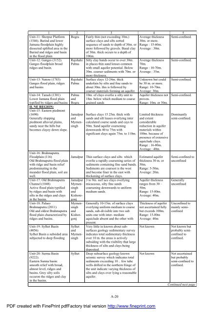
1 2 3 4 5<br />
Unit-11: Sherpur Platform Bogra Fairly thin (not exceeding 10m.) Average thickness Semi-confined.<br />
(1546). Barind and lower<br />
surface clays and silts sorted 30m. or more.<br />
Jamuna floodplain highly<br />
sequence <strong>of</strong> sands to depth <strong>of</strong> 30m. or Range : 15-60m.<br />
dissected uplifted area in <strong>the</strong><br />
more followed by gravels. Basal clay Average : 30m.<br />
Barind and ridges and basin<br />
<strong>of</strong> 30m. thick occurs to a depth <strong>of</strong><br />
in <strong>the</strong> flood plain<br />
106m.<br />
Unit-12: Ganges (3152). Rajshahi Silty clay bands occur to over 30m. Average thickness Semi-confined.<br />
Ganges floodplain broad Pabna in places thin sand lenses common 70m.<br />
ridges and basin.<br />
with small aquifer potential. Below Range : 10-70m.<br />
30m. coarser sediments with 70m. or<br />
more thickness.<br />
Average : 35m.<br />
Unit-13: Natore (1783) Rajshahi Surface clays 12-24m. thick Unknown but could Semi-confined.<br />
Ganges flood plain, ridges Pabna underlain by silts and fine sands to be 30 m. or more.<br />
and basins<br />
about 30m. this is followed by Range: 10-70m.<br />
coarser materials forming an aquifer. Average: 30m.<br />
Unit-14: Tarash (1301) Pabna 10m. <strong>of</strong> clays overlie a silty unit to Aquifer thickness not Semi-confined.<br />
Lower Jamuna flood plain and 18m. below which medium to coarse proven.<br />
typified by ridges and basins<br />
II. NE REGION:<br />
Unit-15: Eastern piedmont<br />
Bogra grained sands<br />
Range: 10m. or 50m.<br />
(1690)<br />
Jamalpur Surface clays 15 25m. thick with Limited thickness Dominantly<br />
Generally slopping and sands and silt leases overlying inter and extent<br />
semi-confined.<br />
piedmont alluvial plains, Mymen- calculated coarse sands and cays to considerable<br />
sandy near <strong>the</strong> hills but singh 50m. Sand aquifer coarsening reduction in aquifer<br />
becomes clayey down slope.<br />
downwards 40 to 75m with<br />
materials within<br />
Unit-16: Brahmaputra<br />
significant clays again 75m. to 110m. 100m. because <strong>of</strong><br />
presence <strong>of</strong> extensive<br />
aquiclude clays.<br />
Range : 16-80m.<br />
Average : 40m.<br />
Floodplain (116)<br />
Jamalpur Thin surface clays and silts which Estimated aquifer Semi-confined to<br />
Old Brahmaputra flood plain<br />
overlie a rapidly coarsening series <strong>of</strong> thickness 30 m. or unconfined<br />
with ridge and basin relief<br />
sediments containing fine sand bands. 50m.<br />
predominating in <strong>the</strong><br />
Sediments are coarsest is <strong>the</strong> west Range: 5-50m.<br />
meander flood plain, soil are<br />
and become finer in <strong>the</strong> east with Average: 20m.<br />
well.<br />
thickening <strong>of</strong> surface clays.<br />
Unit-17: Old Brahmaputra Jamalpur 3 to 9m. surf ace clays overlying Aquifer thickness Generally<br />
Channel (1048)<br />
Mymen- micaceous, silty fine sands<br />
ranges from 30 – unconfined<br />
Active flood plain typified singh coarsening downwards to uniform 50m.<br />
by ridges and basin with and medium sands.<br />
Range: 15-80m.<br />
silts in <strong>the</strong> ridges and clays Kishore-<br />
Average: 40m.<br />
in <strong>the</strong> basins.<br />
gonj<br />
Unit-18: Palaeo<br />
Mymen- Generally 10-15m. <strong>of</strong> surface clays Thickness <strong>of</strong> aquifer Unconfined to<br />
Brahmaputra (2011) singh overlying uniform medium to coarse not ascertained fully mainly semi-<br />
Old and oldest Brahmaputra and sands, sub-divisible into two sub but exceeds 100m. confined<br />
flood plain characterized by Kishor- units one with inter- mediate Range: 15-80m<br />
ridges and basins.<br />
gonj aquiclude absent and <strong>the</strong> o<strong>the</strong>r with<br />
present.<br />
Average: 40m<br />
Unit-19: Sylhet Basin Sylhet Very little in known about sub- Not known Not known but<br />
(4056)<br />
and surfaces geology sedimentary survey<br />
probably semi-<br />
Sylhet Basin a subsided area Mymen- indicates total sedimentary thickness<br />
confined to<br />
subjected to deep flooding singh over 10 m. <strong>the</strong> areas is actively<br />
subsiding with <strong>the</strong> risibility that large<br />
thickness <strong>of</strong> silts and clays being<br />
deposited.<br />
confined.<br />
Unit-20: Surma Basin Sylhet Deep subsurface geology known Not known Not ascertained<br />
(9222).<br />
seismic survey which indicates total<br />
but probably<br />
Eastern Surma basin:<br />
sediments exceeding 10 .. few tube<br />
semi-confined to<br />
smooth relief with broad,<br />
wells drilled in <strong>the</strong> nor<strong>the</strong>rn fringe <strong>of</strong><br />
confined.<br />
almost level, ridges and<br />
<strong>the</strong> unit indicate varying thickness <strong>of</strong><br />
basins. Grey silty soils<br />
silts and clays over lying a reasonable<br />
occuron <strong>the</strong> ridges and clay<br />
in <strong>the</strong> basins.<br />
aquifer.<br />
Continued next page<br />
A-20<br />
PDF created with FinePrint pdfFactory trial version http://www.fineprint.com