

Map Reading Booklet - Ordnance Survey Leisure
Map Reading Booklet - Ordnance Survey Leisure
Map Reading Booklet - Ordnance Survey Leisure

You also want an ePaper? Increase the reach of your titles
YUMPU automatically turns print PDFs into web optimized ePapers that Google loves.
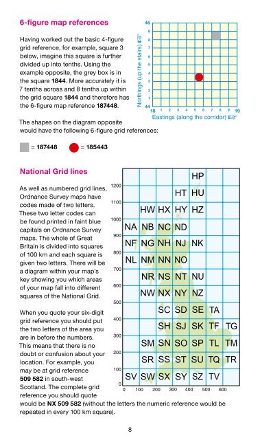
6-figure map references<br />
Having worked out the basic 4-figure<br />
grid reference, for example, square 3<br />
below, imagine this square is further<br />
divided up into tenths. Using the<br />
example opposite, the grey box is in<br />
the square 1844. More accurately it is<br />
7 tenths across and 8 tenths up within<br />
the grid square 1844 and therefore has<br />
the 6-figure map reference 187448.<br />
The shapes on the diagram opposite<br />
would have the following 6-figure grid references:<br />
= 187448 = 185443<br />
National Grid lines<br />
As well as numbered grid lines,<br />
<strong>Ordnance</strong> <strong>Survey</strong> maps have<br />
codes made of two letters.<br />
These two letter codes can<br />
be found printed in faint blue<br />
capitals on <strong>Ordnance</strong> <strong>Survey</strong><br />
maps. The whole of Great<br />
Britain is divided into squares<br />
of 100 km and each square is<br />
given two letters. There will be<br />
a diagram within your map’s<br />
key showing you which areas<br />
of your map fall into different<br />
squares of the National Grid.<br />
When you quote your six-digit<br />
grid reference you should put<br />
the two letters of the area you<br />
are in before the numbers.<br />
This means that there is no<br />
doubt or confusion about your<br />
location. For example, you<br />
may be at grid reference<br />
509 582 in south-west<br />
Scotland. The complete grid<br />
reference you should quote<br />
would be NX 509 582 (without the letters the numeric reference would be<br />
repeated in every 100 km square).<br />
8