Evidence of flexural extension of the Rif foreland : The Rharb ...
Evidence of flexural extension of the Rif foreland : The Rharb ...
Evidence of flexural extension of the Rif foreland : The Rharb ...

Create successful ePaper yourself
Turn your PDF publications into a flip-book with our unique Google optimized e-Paper software.
510 L. ZOUHRI et al.<br />
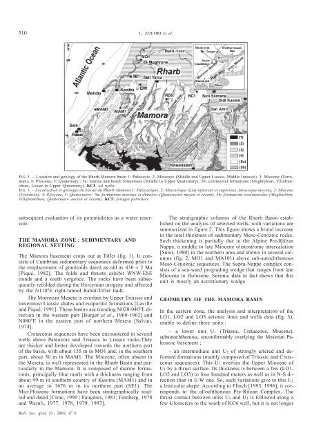
FIG. 1. – Location and geology <strong>of</strong> <strong>the</strong> <strong>Rharb</strong>-Mamora basin 1: Paleozoic, 2: Mesozoic (Middle and Upper Liassic, Middle Jurassic), 3: Miocene (Tortonian),<br />
4: Pliocene, 5: Quaternary : 5a: marine and beach formations (Middle to Upper Quaternary), 5b: continental formations (Moghrebian, Villafranchian,<br />
Lower to Upper Quaternary), KC5. oil wells.<br />
FIG. 1. – Localisation et géologie du bassin du <strong>Rharb</strong>-Mamora 1: Paléozoïque, 2:Mésozoïque (Lias inférieur et supérieur, Jurassique moyen), 3:Miocène<br />
(Tortonien), 4: Pliocène, 5:Quaternaire :5a:formations marines et dunaires (Quaternaire moyen et récent), 5b: formations continentales (Moghrebien,<br />
Villafranchien, Quaternaire ancien et récent), KC5: forages pétroliers.<br />
subsequent evaluation <strong>of</strong> its potentialities as a water reservoir.<br />
THE MAMORA ZONE : SEDIMENTARY AND<br />
REGIONAL SETTING<br />
<strong>The</strong> Mamora basement crops out at Tiflet (fig. 1). It consists<br />
<strong>of</strong> Cambrian sedimentary sequences deformed prior to<br />
<strong>the</strong> emplacement <strong>of</strong> granitoids dated as old as 430 ± 2 Ma<br />
[Piqué, 1982]. <strong>The</strong> folds and thrusts exhibit WNW-ESE<br />
trends and a south vergence. <strong>The</strong> rocks have been subsequently<br />
refolded during <strong>the</strong> Hercynian orogeny and affected<br />
by <strong>the</strong> N110 o E right-lateral Rabat-Tiflet fault.<br />
<strong>The</strong> Morrocan Meseta is overlain by Upper Triassic and<br />
lowermost Liassic shales and evaporitic formations [Laville<br />
and Piqué, 1991]. <strong>The</strong>se basins are trending N020-040 o Edirection<br />
in <strong>the</strong> western part [Burger et al., 1960-1962] and<br />
N080 o E in <strong>the</strong> eastern part <strong>of</strong> nor<strong>the</strong>rn Meseta [Salvan,<br />
1974].<br />
Cretaceous sequences have been encountered in several<br />
wells above Paleozoic and Triassic to Liassic rocks.<strong>The</strong>y<br />
are thicker and better developed towards <strong>the</strong> nor<strong>the</strong>rn part<br />
<strong>of</strong> <strong>the</strong> basin, with about 155 m in MO1 and, in <strong>the</strong> sou<strong>the</strong>rn<br />
part, about 50 m in MAM1. <strong>The</strong> Miocene, <strong>of</strong>ten absent in<br />
<strong>the</strong> Meseta, is well represented in <strong>the</strong> <strong>Rharb</strong> Basin and particularly<br />
in <strong>the</strong> Mamora. It is composed <strong>of</strong> marine formations,<br />
principally blue marls with a thickness ranging from<br />
about 99 m in sou<strong>the</strong>rn country <strong>of</strong> Kenitra (MAM1) and in<br />
an average to 1676 m in its nor<strong>the</strong>rn part (SE1). <strong>The</strong><br />
Mio-Pliocene formations have been stratigraphically studied<br />
and dated [Cirac, 1990 ; Faugères, 1981; Feinberg, 1978<br />
and Wernli, 1977, 1978, 1979, 1987].<br />
Bull. Soc. géol. Fr., 2002, n o 6<br />
<strong>The</strong> stratigraphic columns <strong>of</strong> <strong>the</strong> <strong>Rharb</strong> Basin established<br />
on <strong>the</strong> analysis <strong>of</strong> selected wells, with variations are<br />
summarized in figure 2. This figure shows a brutal increase<br />
in <strong>the</strong> total thickness <strong>of</strong> sedimentary Meso-Cenozoic rocks.<br />
Such thickening is partially due to <strong>the</strong> Alpine Pre-<strong>Rif</strong>ean<br />
Nappe, a middle to late Miocene olistostrome intercalation<br />
[Suter, 1980] in <strong>the</strong> nor<strong>the</strong>rn area and shown in several columns<br />
(fig. 2, MO1 and MA101) above sub-autochthonous<br />
Meso-Cenozoic sequences. <strong>The</strong> Supra-Nappe complex consists<br />
<strong>of</strong> a sea-ward prograding wedge that ranges from late<br />
Miocene to Holocene. Seismic data in fact shows that this<br />
unit is mostly an accretionary wedge.<br />
GEOMETRY OF THE MAMORA BASIN<br />
In <strong>the</strong> eastern zone, <strong>the</strong> analysis and interpretation <strong>of</strong> <strong>the</strong><br />
LO1, LO2 and LO3 seismic lines and wells data (fig. 3),<br />
enable to define three units :<br />
– a lower unit U1 (Triassic, Cretaceous, Miocene),<br />
subautochthonous, unconformably overlying <strong>the</strong> Mesetian Paleozoic<br />
basement ;<br />
– an intermediate unit U2 <strong>of</strong> strongly altered and deformed<br />
formations (mainly composed <strong>of</strong> Triassic and Cretaceous<br />
sequences). This U2 overlies <strong>the</strong> Upper Miocene <strong>of</strong><br />
U1 by a thrust surface. Its thickness is between a few (LO1,<br />
LO2 and LO3) to four hundred meters as well as in N-S direction<br />
than in E-W one. So, such variations give to this U2<br />
a lenticular shape. According to Flinch [1993, 1996], it corresponds<br />
to <strong>the</strong> allochthonous Pre-<strong>Rif</strong>ean Complex. <strong>The</strong><br />
thrust contact between units U1 and U3 is followed along a<br />
few kilometers to <strong>the</strong> south <strong>of</strong> KC6 well, but it is not longer