The Rheic Ocean - Geological Society of America
The Rheic Ocean - Geological Society of America
The Rheic Ocean - Geological Society of America

Create successful ePaper yourself
Turn your PDF publications into a flip-book with our unique Google optimized e-Paper software.
20 o N<br />
D. Upper Cambrian<br />
ridge incision<br />
(ca. 500-490 Ma)<br />
0 250 500<br />
Km<br />
Laramide front<br />
Granjeno<br />
Schist<br />
Acatlán Complex<br />
A. Cadomian back-arc basin<br />
(ca. 590-550 Ma)<br />
Ouachita front<br />
Approximate location<br />
<strong>of</strong> <strong>Rheic</strong> Suture<br />
100 o W<br />
C. Lower-Middle Cambrian<br />
asymmetric rift basin<br />
(ca. 530-500 Ma)<br />
Novillo/<br />
Huiznopala<br />
gneiss<br />
Oaxacan Complex<br />
Maya<br />
terrane<br />
90 o W<br />
B. Cadomian retroarc<br />
basin<br />
(ca. 545-540 Ma)<br />
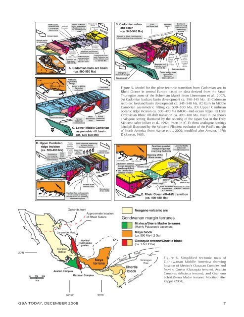
Figure 5. Model for the plate-tectonic transition from Cadomian arc to<br />
<strong>Rheic</strong> <strong>Ocean</strong> in central Europe based on data derived from the Saxo-<br />
Thuringian zone <strong>of</strong> the Bohemian Massif (from Linnemann et al., 2007).<br />
(A) Cadomian backarc basin development ca. 590–545 Ma. (B) Cadomian<br />
retro-arc foreland basin development ca. 545–540 Ma. (C) Early to Middle<br />
Cambrian asymmetric rifting ca. 530–500 Ma. (D) Upper Cambrian<br />
oceanic ridge incision ca. 500–490 Ma (MOR—mid-ocean ridge). (E) Early<br />
Ordovician <strong>Rheic</strong> rift-drift transition ca. 490–480 Ma. Inset in (A) shows<br />
analogous setting illustrated by the opening <strong>of</strong> the Japan Sea in the Early<br />
Miocene (after Jolivet et al., 1992). Insets in (C–E) show analogous settings<br />
(circled) illustrated by the Miocene-Pliocene evolution <strong>of</strong> the Pacific margin<br />
<strong>of</strong> North <strong>America</strong> (from Nance et al., 2002; modified after Atwater, 1970;<br />
Dickinson, 1981).<br />
C a y m a n T r o u g h<br />
Chortis<br />
block<br />
Neogene volcanic arc<br />
Gondwanan margin terranes<br />
Mixteca/Sierra Madre terranes<br />
(Mainly Palaeozoic basement)<br />
Maya block<br />
(ca. 550 Ma-1.2 Ga)<br />
Oaxaquia terrane/Chortis block<br />
(ca. 1.0-1.2 Ga)<br />
H e s<br />
E s c a r p m e n t<br />
E. <strong>Rheic</strong> <strong>Ocean</strong> rift-drift transition<br />
(ca. 490-480 Ma)<br />
Nicaragua<br />
Rise<br />
Figure 6. Simplified tectonic map <strong>of</strong><br />
Gondwanan Middle <strong>America</strong> showing<br />
location <strong>of</strong> Mexico’s Oaxacan Complex and<br />
Novillo Gneiss (Oaxaquia terrane), Acatlán<br />
Complex (Mixteca terrane), and Granjeno<br />
Schist (Sierra Madre terrane). Modified after<br />
Keppie (2004).<br />
GSA ToDAY, December 2008 7