Cape Horn Construction - Central Pacific Railroad Photographic ...
Cape Horn Construction - Central Pacific Railroad Photographic ...
Cape Horn Construction - Central Pacific Railroad Photographic ...

You also want an ePaper? Increase the reach of your titles
YUMPU automatically turns print PDFs into web optimized ePapers that Google loves.
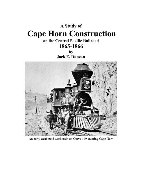
A Study of<br />
<strong>Cape</strong> <strong>Horn</strong> <strong>Construction</strong><br />
on the <strong>Central</strong> <strong>Pacific</strong> <strong>Railroad</strong><br />
1865-1866<br />
by<br />
Jack E. Duncan<br />
An early eastbound work train on Curve 149 entering <strong>Cape</strong> <strong>Horn</strong>
Figure 2 USGS aerial photo of <strong>Cape</strong> <strong>Horn</strong> area
Kirby<br />
Figure 1 Above is an aerial photograph taken in 2004 of the section<br />
of railroad near Colfax, California known as <strong>Cape</strong> <strong>Horn</strong>.<br />
This study focuses on the 1000-foot section of <strong>Central</strong> <strong>Pacific</strong> <strong>Railroad</strong> indicated by the<br />
numbers on the photograph.
Introduction<br />
The discussions in this book were initiated after reading the facts presented by<br />
Ed Strobridge in his book Legend of <strong>Cape</strong> <strong>Horn</strong>. As discussed by Ed, there are virtually<br />
no primary sources written by on-site workers or writers in either the 1860s or 1870s.<br />
There are no known pre-construction or construction photographs. The few 1860s<br />
photographs of other sites that have been found are useable in this study but they offer no<br />
information about construction methods such as blasting, carting spoil and stone<br />
masonry.<br />
Many sources, sources written in later years, are not only unreliable but some of them<br />
enhance legends and amplify incorrect ideas, as described in Legend of <strong>Cape</strong> <strong>Horn</strong>. The<br />
result is that no logical description of construction along that notorious 1000-foot<br />
section of the <strong>Central</strong> <strong>Pacific</strong> <strong>Railroad</strong> in 1865-1866 has been found. The obviously<br />
incorrect writings have survived and grown. I recommend that you first read the book<br />
Legend of <strong>Cape</strong> <strong>Horn</strong> to learn what did not happen. (The many legends referred to are not<br />
repeated in this study). Then read this book to learn what did happen and what I believe<br />
may have happened. Not every opinion stated in this study can be substantiated by<br />
primary documents produced in the 1860s and 1870s.<br />
This book strives to:<br />
First----- present conditions, as they are today, 2005<br />
Second--deduce what conditions existed before construction began in 1865<br />
Third----theorize about how men constructed the roadbed around <strong>Cape</strong> <strong>Horn</strong> Ridge.<br />
This book is in response to some of the following misleading descriptions that have<br />
appeared in literature:<br />
A sheer granite buttress, vertical cliff, nothing between them and their<br />
ancestors but faith, over the side of the cliff on ropes, men swung from the<br />
top in baskets, lowered from the bluff above by ropes, picking away at that<br />
solid granite, almost perpendicular, lowered over the cliff in boson’s chairs,<br />
boson’s chairs swung out into thin air, swaying on a thin rope’s end over<br />
dizzy emptiness, suspended between sky and earth, swaying in the wind, 75<br />
degrees slope, scrambled up the lines, many fell below, many died, an<br />
occasional basket or wide coolie hat would be seen bobbing on the surface<br />
of the American River far below. Not one of these comments has been<br />
found in primary historical documents. They are all fiction.<br />
These comments, plus artist’s drawings, were meant to dramatize the site. They<br />
have perpetuated the boson’s chair and wicker basket legends that Ed described and<br />
commented about. I agree with Ed: the workers did not use either boson’s chairs<br />
or wicker baskets. Based on my findings in this study, the chairs or baskets<br />
would have been unnecessary, impractical, non-functional, inefficient, and<br />
nearly impossible to use and there was no reason to attempt to use them.<br />
References to baskets started only 50 years ago but they have proliferated since that time.
Summary of the Study<br />
This three-year study is reported in a 79-page book that includes 98 figures.<br />
The study, results and discussion are summarized in these 5 pages.<br />
Preliminary Survey Theodore Judah’s 1861 preliminary survey map (60 to 90<br />
feet long) reveals significant differences from the alignment that was actually built (in<br />
California). Of interest, near <strong>Cape</strong> <strong>Horn</strong>, are two facts:<br />
First: Judah intended to cross Long Ravine Gap with a curved track that must<br />
have been on either earthen fill or a trestle. Montague chose to use a straight bridge that<br />
required realignment to accommodate the straight bridge section.<br />
Second: Judah intended to curve the track further into the hill at <strong>Cape</strong> <strong>Horn</strong> thus<br />
reducing or eliminating the two retaining walls and fills.<br />
Figure 17 This is an overlay of a 1973 USGS map onto Judah’s 1861 preliminary map.<br />
The alignments around <strong>Cape</strong> <strong>Horn</strong> Ridge are similar but not exact. The differences at<br />
Long Ravine and at <strong>Cape</strong> <strong>Horn</strong> are visible.<br />
<strong>Construction</strong> Survey This section examines the reasons for locating the track bed<br />
at the 2500 feet elevation instead of locating it either higher or lower. The two gaps, Long<br />
Ravine and Secret Town, dictated the elevation at <strong>Cape</strong> <strong>Horn</strong>. Higher would have been<br />
easier while lower would have been far more difficult.<br />
Surveyors possibly used safety ropes at a few locations to place stakes but there was no<br />
reason for the excavation laborers to use either chairs or baskets.
Figure 18 Choosing the best elevation for crossing Long Ravine Gap required<br />
compromising on the fill/trestle/bridge/cut as shown. The three cart roads that were used<br />
in 1865 are visible in the cut.<br />
Order of Events This section examines the likely order of construction<br />
around <strong>Cape</strong> <strong>Horn</strong> Ridge. There was no engineering reason that prevented excavation at<br />
<strong>Cape</strong> <strong>Horn</strong> simultaneous with excavation both west and east of that steep hillside.<br />
West <strong>Cape</strong> <strong>Horn</strong> The one-mile section along the west side of <strong>Cape</strong> <strong>Horn</strong><br />
Ridge is addressed as a separate excavation project since conditions differed from those<br />
at <strong>Cape</strong> <strong>Horn</strong> and there was no apparent reason to coordinate activities at the two areas.<br />
Some horse/cart transport of cuttings was employed here but use of carts at <strong>Cape</strong> <strong>Horn</strong><br />
appears to be extremely unlikely. Both cutting and filling were required along this<br />
hillside.<br />
East <strong>Cape</strong> <strong>Horn</strong> The one-mile section east of <strong>Cape</strong> <strong>Horn</strong> is also addressed<br />
as a separate activity for the same reason. This cut and fill was easier to accomplish than<br />
was that along West <strong>Cape</strong> <strong>Horn</strong> because the terrain was relatively less sloped. Referring<br />
back to the construction survey, construction east of <strong>Cape</strong> <strong>Horn</strong> would have been<br />
extremely difficult had the track level been only 100 feet lower.<br />
<strong>Cape</strong> <strong>Horn</strong> Appearance in 2004 About 140 slope measurements were recorded along<br />
the 1000 foot <strong>Cape</strong> <strong>Horn</strong> in 2004 using the slope gauge shown in Figure 32. This<br />
convenient tool was used along the roadbed, also above and below the roadbed. Using<br />
these slope figures, cross sections of the existing cut were drawn at each 100-foot station.<br />
The reader can develop an excellent idea of the volume of rock that has been cut along<br />
this hillside by examining these cross sections. The vast majority of this excavation<br />
occurred in 1929, not in 1865.
Figure 32 Slope gauge with weighted pointer reads 36 degrees. While using surveyor’s<br />
equipment could make more precise measurements, this simple tool easily measured<br />
within 1 degree, which is adequate for this study.<br />
<strong>Cape</strong> <strong>Horn</strong> Appearance in 1866 This somewhat technical section describes the cut<br />
as it existed when rails were laid in 1866.<br />
Also, cross sections were developed in this section as they existed in 1866.<br />
The procedure used for developing the cross sections used drawings and photos from the<br />
1860s and early 1870s. The results of this back engineering procedure are shown in<br />
Figure 51. Modifying the 2004 Figure 52 developed this figure. The purpose of Figure 51<br />
is to show the small early cut compared to the present large cut. Brush and tree coverage<br />
is of course artificial but it is intended to indicate rather sparse cover as determined from<br />
many photos in the 1870s.
Figure 51 <strong>Cape</strong> <strong>Horn</strong> in 1866 after completion of construction.<br />
Figure 52 <strong>Cape</strong> <strong>Horn</strong> in 2004. Most of the additional cutting and some retaining wall<br />
improvements occurred in 1929. After 16 years of abandonment (1913-1929) this<br />
roadbed was improved allowing the eastbound, uphill traffic to be removed from Tunnels<br />
33 and 34, and returned to this original 1866 location.<br />
Dip of the Ledge This term was used by Montague to describe conditions at <strong>Cape</strong><br />
<strong>Horn</strong>. His statement was “The dip of the ledge is about seventy-five degrees, or nearly<br />
perpendicular….”. Many authors and artists have misunderstood this to mean that the<br />
mountain surface sloped 75 degrees. Analysis of conditions as they existed indicates that<br />
this interpretation was incorrect leading to legends and drawings that were presented as
facts. Examination of the rocks and terrain has lead us to a different understanding of<br />
Montague’s comment. This analysis is described in detail in the book.<br />
Retaining Walls at <strong>Cape</strong> <strong>Horn</strong> This section describes the construction, repairs and<br />
replacement of the retaining walls in two ravines. Indications are that skilled craftsmen<br />
did not do the original stone mason work. Both walls needed either repairs or<br />
replacement within a few years.<br />
Later <strong>Construction</strong>---After 1866 This section is a general catchall. It includes<br />
repairs, the little known steel truss bridge, guard rails, re-alignment and re-location of the<br />
tracks, addition of concrete parapet walls and a look at camera locations for both early<br />
and recent photos.<br />
Appendix This contains references and sketches that support the study.<br />
Below the <strong>Railroad</strong> While there was probably no work done below the rail bed, it is<br />
helpful to understand some of the commentary in the earlier sections of this study. This<br />
includes searching for the elusive 75-degree slope.
About the Author<br />
Jack’s early years were spent in a small lumber town in the Sierra, Stirling<br />
City. That was a company town for over 50 years, owned and managed by the Diamond<br />
Match Company. Hauling logs from the woods to the mill was by Shay locomotives<br />
supported by small 0-6-0 saddle tank Porter yard engines. The lumber was then hauled to<br />
market by Southern <strong>Pacific</strong>. His father built and maintained the log hauling railroad cars.<br />
Riding in the engine cab or on the flat cars was allowed in those days. <strong>Railroad</strong>ing was<br />
fun for teenaged kids.<br />
Company men operating D8 logging Cats with bulldozer blades built the railroads<br />
and truck roads in the woods. Jack was fascinated by the accomplishments of these<br />
operators on steep hillsides. They seemed to never make a mistake.<br />
After graduating from UC Berkeley as a mechanical engineer he devoted most of his<br />
career to nuclear explosives but some other experiences involved photo analysis,<br />
surveying, civil engineering and foreign construction analysis. Probably the experience of<br />
analyzing construction activities, by studying overhead photographs in detail, was the<br />
most useful training of all for this study.<br />
While Jack is not a railroad historian, he decided to use some of his experiences as<br />
an engineer to try to understand how the <strong>Central</strong> <strong>Pacific</strong> <strong>Railroad</strong> men built the road<br />
around <strong>Cape</strong> <strong>Horn</strong>. He became interested in that construction while reading the book<br />
Legend of <strong>Cape</strong> <strong>Horn</strong>.<br />
This study made use of most of the experiences mentioned above.<br />
Previous to this study, he wrote the history book To Donner Pass from the <strong>Pacific</strong>. That<br />
book is a 150-year history of roads across California along the present I-80, primarily in<br />
the Sierra Nevada Mountains.
An eastbound freight train on curve 150 leaving <strong>Cape</strong> <strong>Horn</strong> in 2004
The book is available at Big Bend Ranger Station, Dutch Flat Historical Society, Placer<br />
Sierra <strong>Railroad</strong> Heritage Society, Placer County Historical Society and Smith’s<br />
Bookstore in Auburn. It is also available from the author.<br />
Jack E. Duncan 530-888-6027<br />
8555 Crater Hill Road jcduncan@psyber.com<br />
Newcastle, CA, 95658<br />
Retail price $13.95<br />
plus $1.05 tax in California<br />
$2.00 if mailed