Cape Horn Construction - Central Pacific Railroad Photographic ...
Cape Horn Construction - Central Pacific Railroad Photographic ...
Cape Horn Construction - Central Pacific Railroad Photographic ...

You also want an ePaper? Increase the reach of your titles
YUMPU automatically turns print PDFs into web optimized ePapers that Google loves.
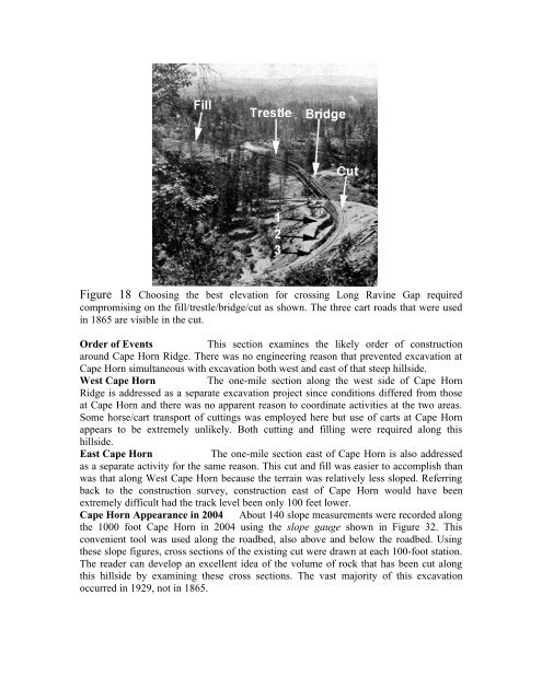
Figure 18 Choosing the best elevation for crossing Long Ravine Gap required<br />
compromising on the fill/trestle/bridge/cut as shown. The three cart roads that were used<br />
in 1865 are visible in the cut.<br />
Order of Events This section examines the likely order of construction<br />
around <strong>Cape</strong> <strong>Horn</strong> Ridge. There was no engineering reason that prevented excavation at<br />
<strong>Cape</strong> <strong>Horn</strong> simultaneous with excavation both west and east of that steep hillside.<br />
West <strong>Cape</strong> <strong>Horn</strong> The one-mile section along the west side of <strong>Cape</strong> <strong>Horn</strong><br />
Ridge is addressed as a separate excavation project since conditions differed from those<br />
at <strong>Cape</strong> <strong>Horn</strong> and there was no apparent reason to coordinate activities at the two areas.<br />
Some horse/cart transport of cuttings was employed here but use of carts at <strong>Cape</strong> <strong>Horn</strong><br />
appears to be extremely unlikely. Both cutting and filling were required along this<br />
hillside.<br />
East <strong>Cape</strong> <strong>Horn</strong> The one-mile section east of <strong>Cape</strong> <strong>Horn</strong> is also addressed<br />
as a separate activity for the same reason. This cut and fill was easier to accomplish than<br />
was that along West <strong>Cape</strong> <strong>Horn</strong> because the terrain was relatively less sloped. Referring<br />
back to the construction survey, construction east of <strong>Cape</strong> <strong>Horn</strong> would have been<br />
extremely difficult had the track level been only 100 feet lower.<br />
<strong>Cape</strong> <strong>Horn</strong> Appearance in 2004 About 140 slope measurements were recorded along<br />
the 1000 foot <strong>Cape</strong> <strong>Horn</strong> in 2004 using the slope gauge shown in Figure 32. This<br />
convenient tool was used along the roadbed, also above and below the roadbed. Using<br />
these slope figures, cross sections of the existing cut were drawn at each 100-foot station.<br />
The reader can develop an excellent idea of the volume of rock that has been cut along<br />
this hillside by examining these cross sections. The vast majority of this excavation<br />
occurred in 1929, not in 1865.