Tribute to Dr. Akoi Kouadio - Sirenian International
Tribute to Dr. Akoi Kouadio - Sirenian International
Tribute to Dr. Akoi Kouadio - Sirenian International

Create successful ePaper yourself
Turn your PDF publications into a flip-book with our unique Google optimized e-Paper software.
OCTOBER<br />
April 2007<br />
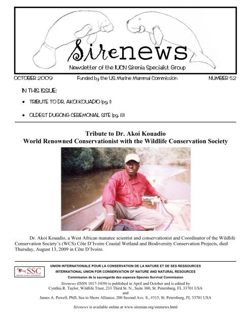
2009 Funded by the US Marine Mammal Commission NUMBER<br />
Number<br />
52<br />
47<br />
IN THIS ISSUE:<br />
• TRIBUTE TO DR. AKOI KOUADIO (pg. 1)<br />
Sirenews<br />
Newsletter of the IUCN Sirenia Specialist Group<br />
• OLDEST DUGONG CEREMONIAL SITE (pg. 8)<br />
<strong>Tribute</strong> <strong>to</strong> <strong>Dr</strong>. <strong>Akoi</strong> <strong>Kouadio</strong><br />
World Renowned Conservationist with the Wildlife Conservation Society<br />
<strong>Dr</strong>. <strong>Akoi</strong> <strong>Kouadio</strong>, a West African manatee scientist and conservationist and Coordina<strong>to</strong>r of the Wildlife<br />
Conservation Society’s (WCS) Côte D’Ivoire Coastal Wetland and Biodiversity Conservation Projects, died<br />
Thursday, August 13, 2009 in Côte D’Ivoire.<br />
UNION INTERNATIONALE POUR LA CONSERVATION DE LA NATURE ET DE SES RESSOURCES<br />
INTERNATIONAL UNION FOR CONSERVATION OF NATURE AND NATURAL RESOURCES<br />
Commission de la sauvegarde des especes-Species Survival Commission<br />
Sirenews (ISSN 1017-3439) is published in April and Oc<strong>to</strong>ber and is edited by<br />
Cynthia R. Taylor, Wildlife Trust, 233 Third St. N., Suite 300, St. Petersburg, FL 33701 USA<br />
and<br />
James A. Powell, PhD, Sea <strong>to</strong> Shore Alliance, 200 Second Ave. S., #315, St. Petersburg, FL 33701 USA<br />
Sirenews is available online at www.sirenian.org/sirenews.html
<strong>Dr</strong>. <strong>Kouadio</strong>’s quiet demeanor belied the deep conviction and passion he had for the protection of<br />
manatees and Ivorian wildlife and forests.<br />
<strong>Dr</strong>. <strong>Kouadio</strong> spent more than 30 years of his life working principally on West African manatee research,<br />
education and conservation. He was highly regarded as one of the world’s foremost experts on West African<br />
manatees.<br />
The son of a cocoa farmer, <strong>Dr</strong>. <strong>Kouadio</strong> began his conservation efforts as a young Officer of the Ivorian<br />
Ministry of Water and Forests serving as assistant direc<strong>to</strong>r of the Azagny National Park. After four years at the<br />
Azagny Park, <strong>Dr</strong>. <strong>Kouadio</strong> chose <strong>to</strong> pursue his true love and passion: the conservation of manatees.<br />
Beginning in January of 1989, <strong>Dr</strong>. <strong>Kouadio</strong> developed the Wildlife Conservation Society’s West African<br />
Manatee Conservation and Education Project in the coastal lagoons of Côte D’Ivoire close <strong>to</strong> Azagny. During<br />
the course of the next several years, he conducted research and worked closely with leading experts <strong>to</strong> develop a<br />
manatee conservation project, including the establishment of an educational program for the local fishing<br />
communities and sponsoring s<strong>to</strong>ry-telling competitions and inspiring nature clubs. His work also continued in<br />
Azagny National Park, which includes important populations of elephants, West African chimpanzees and<br />
pygmy hippopotamuses.<br />
Since July 2003, <strong>Dr</strong>. <strong>Kouadio</strong> acted as Coordina<strong>to</strong>r of WCS’s Coastal Wetland and Biodiversity<br />
Conservation Project, based in Côte D’Ivoire. While managing this project, <strong>Dr</strong>. <strong>Kouadio</strong> was awarded his PhD<br />
in 2004 from the University of Kent, UK. He remained as Coordina<strong>to</strong>r until his death.<br />
<strong>Dr</strong>. <strong>Kouadio</strong>’s work with West African manatees was one of the few bright spots for this creature. WCS<br />
is deeply concerned that this already vulnerable species is close <strong>to</strong> being eradicated from much of its range<br />
throughout West Africa. The loss of <strong>Dr</strong>. <strong>Kouadio</strong> means the manatees have lost a true champion and someone<br />
who was able <strong>to</strong> develop solutions <strong>to</strong> the many threats the manatees face in the region jeopardizing their longterm<br />
survival.<br />
Many of <strong>Dr</strong>. <strong>Kouadio</strong>’s colleagues recall his truly remarkable ability <strong>to</strong> create bonds and build<br />
friendships across cultures and communities. They say this trust and respect made <strong>Dr</strong>. <strong>Kouadio</strong> a powerful and<br />
very effective environmental teacher and conservationist. “A truly dedicated individual, and a champion of<br />
conservation, <strong>Dr</strong>. <strong>Kouadio</strong> will be missed tremendously,” says John Robinson, the Executive Vice President for<br />
Conservation and Science at the Wildlife Conservation Society. “<strong>Dr</strong>. <strong>Kouadio</strong>’s death creates a void in the<br />
sphere of conservation of aquatic mammals, especially the West African manatee. The commitment he showed<br />
<strong>to</strong> conservation is unmatchable. The Wildlife Conservation Society has lost a great colleague.”<br />
<strong>Dr</strong>. <strong>Kouadio</strong> died at age 47. He is survived by his wife, Mme. <strong>Akoi</strong> <strong>Kouadio</strong> née Ahou Juliette and<br />
daughter, Marguerite <strong>Akoi</strong>.<br />
Special Note – WCS would be glad <strong>to</strong> facilitate private donations <strong>to</strong> the family of <strong>Dr</strong>. <strong>Akoi</strong> <strong>Kouadio</strong> in Côte D’Ivoire <strong>to</strong> help them<br />
through this difficult time.<br />
To make a donation by check, please contact Amy Pokempner at apokempner@wcs.org for details. Please include in your email <strong>to</strong><br />
Amy the subject line “<strong>Akoi</strong> <strong>Kouadio</strong> Family Fund”. Please remember that, in accordance with the requirements of the U.S. Internal<br />
Revenue Code, any such donation would not be tax deductible <strong>to</strong> a U.S. taxpayer.<br />
Edi<strong>to</strong>r’s Note – <strong>Akoi</strong> and I met in 1986 when I began a research project on West African manatees in Côte<br />
d’Ivoire. He and I worked closely <strong>to</strong>gether for three years. During that time, his passion for manatees grew and<br />
his commitment as a conservation biologist strengthened. <strong>Akoi</strong> was my colleague, friend, teacher, transla<strong>to</strong>r<br />
and doc<strong>to</strong>r during those years living in the bush of West Africa. I shall forever be grateful <strong>to</strong> him. I will<br />
remember <strong>Akoi</strong> as one of the most gentle, kind, considerate and dedicated individuals I have ever met.<br />
Sirenews No. 52 2 Oc<strong>to</strong>ber 2009
The survival of endangered manatees in Côte d’Ivoire will be attributed <strong>to</strong> his lifelong achievements. –Buddy<br />
Powell<br />
JAPANESE NGOs PROMOTE “2010 INTERNATIONAL YEAR OF THE DUGONG”<br />
As the result of the adoption of “Promotion of Dugong during the UN 2010 <strong>International</strong> Year for<br />
Biodiversity” at the 4th IUCN World Conservation Congress, Japanese NGOs (including WWF Japan) decided<br />
<strong>to</strong> announce the year 2010 as the “<strong>International</strong> Year of the Dugong”. It will increase awareness of the present<br />
situation of the dugong worldwide. Throughout the year 2010, various promotional activities will be held.<br />
WWF Japan is now calling on related groups all over the world <strong>to</strong> support “2010 the <strong>International</strong> Year of the<br />
Dugong”. Promotional posters, leaflets and activities schedules will be available on WWF Japan’s website<br />
(scheduled <strong>to</strong> be available in November): http://www.wwf.or.jp/dugong/.<br />
The Save the Dugong Campaign Center (SDCC) is now conducting an online petition campaign <strong>to</strong> “Call<br />
for Immediate Implementation of the IUCN Resolution for Dugong Conservation”. Please take action now!<br />
http://www.thepetitionsite.com/1/save-the-okinawa-dugong<br />
One urgent case is in Okinawa, Japan, where the northernmost dugongs in this habitat face the<br />
possibility of extinction due <strong>to</strong> Japanese and U.S. government plans <strong>to</strong> construct a U.S. Marine Corps facility. It<br />
is crucial <strong>to</strong> create an international framework <strong>to</strong> promote the understanding of and implement existing and<br />
forthcoming measures for dugong conservation while also calling for the responsibility and accountability of the<br />
Japanese and US governments in their undertaking of the construction plan.<br />
In January 2008, however, the U.S. Federal District Court delivered an extremely important decision,<br />
ruling that the U.S. government was responsible and had failed <strong>to</strong> comply with the National His<strong>to</strong>rical<br />
Preservation Act (NHPA) in drawing up the construction plan. The court also ordered the U.S. government <strong>to</strong><br />
comply with the NHPA by reviewing the Japanese government’s environmental impact assessment (EIA) and <strong>to</strong><br />
find a way <strong>to</strong> avoid or mitigate adverse effects on the dugong from the construction of the facility. The U.S.<br />
court decision provides an excellent opportunity and a vital framework for the IUCN Congress <strong>to</strong> urge the<br />
Japanese and US governments <strong>to</strong> conduct a joint EIA for the conservation of the Okinawa Dugong.<br />
For your reference, you can find the resolution of the World Conservation Congress in Barcelona, 2008,<br />
at the following website:<br />
http://intranet.iucn.org/webfiles/doc/IUCNPolicy/Resolutions/2008_WCC_4/English/RES/res_4_022_promotio<br />
n_of_dugong_during_the_un_2010_international_year_for_biodiversity.pdf<br />
For further information, please contact <strong>to</strong> Yoshiko Machida, Senior Communication Officer, WWF Japan<br />
e-mail:machida@wwf.or.jp tel: +81 3 3769 1713<br />
REPORT FROM THE SCB INTERNATIONAL MARINE CONSERVATION CONGRESS<br />
WORKSHOP ON IMPROVING THE CONTRIBUTION OF MARINE PROTECTED AREAS TO THE<br />
CONSERVATION OF SIRENIANS<br />
A four day workshop from 21-24 May 2009 was held at the Society for Conservation Biology’s<br />
<strong>International</strong> Marine Conservation Congress at George Mason University in Fairfax, Virginia, USA.<br />
Attendance ranged from 26-36 participants over the four days from 16 countries, including Australia, Belize,<br />
Brazil, Colombia, Cote d’Ivoire, Dominican Republic, Guatemala, India, Japan, Malaysia, Mexico, Senegal,<br />
South Africa, United Arab Emirates, USA, and the UK. The U.S. Marine Mammal Commission was the main<br />
sponsor of the workshop, providing much needed travel funds for participants from around the world.<br />
Sirenews No. 52 3 Oc<strong>to</strong>ber 2009
Seventeen speakers gave presentations during the first three days of the workshop (abstracts presented below in<br />
the Abstracts section), and five posters were presented. The final day of the workshop consisted of an<br />
interactive group exercise facilitated by Helene Marsh on developing effective protected areas for sirenians in<br />
developing countries.<br />
A bulleted summary of the interactive session is presented below:<br />
1. SWOT analysis of Protected Areas as a <strong>to</strong>ol <strong>to</strong> reduce the risk <strong>to</strong> sirenians in developing countries<br />
Strengths of Protected Areas:<br />
• Identifies areas for protection<br />
• Legal framework of the Protected Area<br />
• Access <strong>to</strong> funding<br />
• Inclusion of sirenians as flagship species within the species <strong>to</strong> protect<br />
• Official presence within the areas<br />
• Attracts civil support (NGO, community, university)<br />
Weaknesses of Protected Areas:<br />
• Mostly <strong>to</strong>o small<br />
• Low representation of the range of sirenians<br />
• Not usually implemented<br />
• No rules; creation of a paper park<br />
• Enforcement is lax<br />
• Many are multiple use<br />
• Massive <strong>to</strong>urism<br />
• Lack of continuous funding<br />
• Based on inadequate knowledge of sirenians<br />
• Capacity deficit of park staff<br />
• Often dependent on the enthusiasm and energy of short term champions<br />
• Lack of succession planning for managers and scientists<br />
• Ephemeral funding<br />
• Lack of alternative livelihoods<br />
• May not resolve hunting problems<br />
• Top-down imposition of rules and regulations<br />
• Mismatch between geopolitical and ecological scales<br />
Opportunities that could potentially be provided by Protected Areas<br />
• Multiple use areas can be designed <strong>to</strong> meet different objectives<br />
• Community involvement in conservation<br />
• Funding<br />
• Educational outreach<br />
• Research<br />
• Improved habitat protection<br />
• Hunting controls<br />
Sirenews No. 52 4 Oc<strong>to</strong>ber 2009
• High protection for areas of high sirenian density migra<strong>to</strong>ry corridors<br />
• Buffer zones<br />
• Influence behavior of impacting communities including communities external <strong>to</strong> protected area<br />
• Protection at range of temporal and spatial scales<br />
• Advocacy<br />
• Co-management<br />
• <strong>Sirenian</strong>s as flagships<br />
• Livelihood <strong>to</strong> the local people.<br />
• Enhancement of cultural rights<br />
Threats <strong>to</strong> <strong>Sirenian</strong>s in Protected Areas:<br />
• Unsustainable <strong>to</strong>urism<br />
• Illegal hunting<br />
• Continued use of fishing gear that causes sirenian mortality and destroys habitat<br />
• Lack of continuous funding<br />
• Lack of connectivity between protected areas<br />
• Illusion of protection<br />
• Deleterious activities can influence the creation of protected areas<br />
• Failure <strong>to</strong> manage impacts outside the protected area<br />
• Political conflict between nation states<br />
• Lack of political will <strong>to</strong> manage the protected areas<br />
2. Features of a Protected Area that reduce the risk <strong>to</strong> sirenians in developing countries<br />
1. Community involvement that incorporates local knowledge<br />
2. Management plan that reflects legal framework and includes goals specific <strong>to</strong> sirenians<br />
3. Legal framework with political will <strong>to</strong> implement protected area<br />
4. Strong education and outreach program<br />
5. Protected Area network large enough <strong>to</strong> protect ecological processes and include a high proportion of<br />
the sirenian population throughout the year<br />
6. Long-term funding adequate <strong>to</strong> implement management plan<br />
7. Co-management involving government, NGOs, local communities and researchers<br />
8. Effective enforcement of management plan<br />
9. Capacity building including succession planning for all partners in the co-management arrangement:<br />
government, NGOS, community, researchers<br />
10. Management informed by active research program<br />
11. Alternative livelihoods for those community members affected by the implementation of the<br />
management plan<br />
Additional recommendations<br />
• Reduction of human-induced mortality <strong>to</strong> sirenians should be the highest priority for sirenian<br />
conservation.<br />
• Regional workshops and community level exchanges would provide valuable opportunities <strong>to</strong> exchange<br />
ideas.<br />
• Workshop on the challenge of eco<strong>to</strong>urism as an alternative livelihood would be timely.<br />
Sirenews No. 52 5 Oc<strong>to</strong>ber 2009
-Helene Marsh 1 , Caryn Self-Sullivan 2 , Ellen Hines 3 , and Cyndi Taylor 4 ( 1 helene.marsh@jcu.edu.au,<br />
2 caryns@sirenian.org, 3 ehines@sfsu.edu, 4 taylor@wildlifetrust.org)<br />
CUBA<br />
LOCAL NEWS<br />
Report from the Second Cuban Sea Turtle and Marine Mammal Necropsy Workshop. The Second<br />
Sea Turtle and Marine Mammal Necropsy Workshop in Cuba was held at the Central University “Marta Abreu”<br />
of Villa Clara from 22-24 April 2009. The workshop was organized jointly through collaborations with the<br />
Marine Research Centre of Havana University (CIM), the National Enterprise for the Protection of Flora and<br />
Fauna (ENPFF) and the University of Villa Clara, within the framework of the Fourth <strong>International</strong> Conference<br />
of Agriculture. Special support was provided by Wildlife Trust, the Sea <strong>to</strong> Shore Alliance and the John D. and<br />
Catherine T. MacArthur Foundation. Specialists from the United States, Puer<strong>to</strong> Rico, and Belize participated in<br />
the workshop, along with 25 biologists and veterinarians from various marine protected areas within Cuba. The<br />
main goal was <strong>to</strong> increase knowledge and skills in order <strong>to</strong> analyze mortality events of sea turtles and marine<br />
mammals throughout Cuba. A manatee carcass was transported from Florida and theoretical and practical work<br />
sessions were conducted on ana<strong>to</strong>my, stranding proceedings, sample collection and experiences from other<br />
countries. The workshop was an opportunity for the sharing of knowledge and information between Cubans and<br />
colleagues from other countries. –Anmari Alvarez (Marine Research Centre of Havana University,<br />
anmari@cim.uh.cu)<br />
SOLOMON ISLANDS<br />
Interview surveys <strong>to</strong> establish dugong population status in the Solomon Islands. In 2008 and 2009<br />
interview surveys were conducted in Papua New Guinea and the Solomon Islands <strong>to</strong> establish population status,<br />
distribution and mortality of dugongs.<br />
Several surveys for dugongs have been conducted in Papua New Guinea since the 1970’s. Hudson<br />
(1976) conducted postal surveys in Papua New Guinea in 1973-74 and listed the Samarai Islands of Milne Bay,<br />
Kairiru Island off Wewak, and Lou and St. Andrew Island groups off Manus as the most important areas for<br />
dugong conservation in Papua New Guinea. In 1977, Ligon and Hudson conducted aerial surveys of Lae, the<br />
southeast and northwest coasts of Papua New Guinea and the northwest coast of West New Britain. The most<br />
recent dugong surveys were done in the Samarai Islands in Milne Bay Province (Yen 2006). Whilst there are<br />
records for dugong sightings in the Solomon Islands, no specific surveys have been done <strong>to</strong> assess dugong<br />
abundance.<br />
Survey locations were targeted for this survey, based on the previous survey data, advice from local<br />
fishermen and available seagrass habitat mapping. Surveys were completed in Manus, Bougainville and four<br />
provinces of the Solomon Islands. We hope <strong>to</strong> continue this work in other provinces of Papua New Guinea as<br />
funding becomes available.<br />
Interviews were conducted in 13 coastal locations on the island of Manus in Jan-Feb 2008. A <strong>to</strong>tal of 64<br />
adults and 18 dugong calves were reported along the coast of the main island and surrounding smaller islands of<br />
Manus (Figure 1). Respondents estimated <strong>to</strong> have seen approximately 952 dugongs in the past 5 years around<br />
Manus. The areas that were reported as supporting the largest number of dugongs were Malabang, Pere, Tawi<br />
Island and Sori Island.<br />
Sirenews No. 52 6 Oc<strong>to</strong>ber 2009
Figure 1. Dugong sightings recorded for Manus in 2008 compared with 1974 surveys.<br />
A <strong>to</strong>tal of 34 stranded dugongs were reported since the 1980’s. More than half of these were trapped in<br />
nets. Whilst dugongs are hunted in Manus, on average people reported that only 1-2 dugongs are caught in their<br />
village each year. Seventeen percent of people interviewed do not eat dugong because of religious beliefs or<br />
taboos and 35% percent of respondents had eaten dugong in the last year.<br />
Interviews were conducted in 25 locations in 5 coastal areas of Bougainville (Figure 2). A <strong>to</strong>tal of 20<br />
adults and 10 calves were reported for the period from Jan-Feb 2008, with a <strong>to</strong>tal of 37 adults and 17 calves<br />
reported overall for 2007-2008. There were six dugong strandings reported since 2003. Fifty two percent of<br />
respondents do not eat dugong. Dugongs are not usually consumed by local communities, unless one is found<br />
trapped in a net, or in times of crisis when food is in short supply.<br />
Figure 2. Dugong distribution in Bougainville recorded in the 2008 survey.<br />
Interview surveys were conducted with 98 people from 24 locations in Malaita, Central, Isabel and<br />
Western Provinces of the Solomon Islands in February 2009. A <strong>to</strong>tal of 300 dugongs were reported and<br />
respondents estimated having seen 742 in the past 10 years. A <strong>to</strong>tal of 56 dugongs were reported stranded from<br />
nets but this was both accidental and intentional netting. Whilst dugong are hunted in 47% of the areas<br />
Sirenews No. 52 7 Oc<strong>to</strong>ber 2009
surveyed, only 36% of people reportedly eat dugong, and generally only once or twice a year. -Deborah Bass<br />
(Conservation <strong>International</strong>, Indonesian-Pacific Field Division, 47 Maunds Road, Ather<strong>to</strong>n 4883, QLD. Tel: 07<br />
40918830, debbbass@hotmail.com)<br />
Figure 3. Dugong distribution in the Solomon Islands recorded from 2009 survey.<br />
References<br />
Hudson, B. E. T. 1976. Dugong: distribution, hunting, protective legislation and cultural significance in Papua<br />
New Guinea. Konedobu, Papua New Guinea, Wildlife Division, Department of Lands and Environment.<br />
Ligon, S. and B. E. T. Hudson. 1977. Aerial survey of the dugong Dugong dugon in Papua New Guinea,<br />
Wildlife in Papua New Guinea. Konedobu, Papua New Guinea, Wildlife Division, Department of Lands and<br />
Environment. 77: 53-76.<br />
Yen, Robert. 2006, Preliminary assessment of the status of dugong population in Samarai, Milne Bay Province.<br />
The Milne Bay Community-Based Coastal and Marine Conservation Project.<br />
UNITED ARAB EMIRATES<br />
The oldest sanctuary dedicated <strong>to</strong> the dugong (Dugong dugon): Akab Island (Umm al-Quwain U.A.E.). The<br />
French archaeological mission <strong>to</strong> the United Arab Emirates and the museum of the Umm al-Quwain Emirate<br />
(UAE) have recently discovered the oldest sanctuary in Arabia (3500-3200 BC), as well as the oldest known<br />
ceremonial site dedicated <strong>to</strong> the dugong (Dugong dugon).<br />
Introduction<br />
The Arabian Peninsula has provided very little data on the beliefs and ritual practices that preceded Islam. Located<br />
in the United Arab Emirates, near the Strait of Hormuz, the Akab sanctuary (3500 BC) <strong>to</strong>day provides us with the<br />
first evidence of the rituals practised by the prehis<strong>to</strong>ric coastal societies of the Gulf.<br />
Test excavations were made in the “dugong mound” of Akab in the 1990’s and it was interpreted as a sea<br />
cow butchering site. The excavation was resumed between 2006 and 2009 by a new team of pre-his<strong>to</strong>rians and<br />
faunal experts of the French mission. This work has shown that this is not an unorganized accumulation of bones,<br />
Sirenews No. 52 8 Oc<strong>to</strong>ber 2009
ut an intentionally structured one whose construction was accomplished in stages. A 14 C dating realized directly<br />
on a dugong bone attributes it <strong>to</strong> the second half of the fourth millennium (5140 ± 55 BP. 3568-3116 BC) (Méry &<br />
al 2009). This complex construction consists of an ovoid platform extending <strong>to</strong> approximately 10 m 2 and 40 cm in<br />
height. It contains the remains of at least forty dugongs. The <strong>to</strong>p level was organised with two rows of skulls<br />
directed <strong>to</strong>ward the east and a third row of skulls with the same orientation on the northern edge of the mound. All<br />
of the skulls were carefully wedged in<strong>to</strong> place with the premaxilla deeply embedded in<strong>to</strong> the lower part of the<br />
structure and wedges of ribs, sometimes doubled or even tripled, placed all around them. Bundles of ribs were<br />
deposited just in front of the first row of skulls <strong>to</strong> the east.<br />
The lower level of the platform was almost entirely impregnated with an ochre solution that reddened the<br />
bones and the natural sediment. This level is characterised by dugong mandibles laid flat, and it some areas, piled<br />
several high.<br />
Juveniles, including very young dugongs, are well represented in the mound. We also observe that no<br />
animal was deposited whole in the structure, or even a large part of an animal. Moreover, certain ana<strong>to</strong>mical parts,<br />
such as the ribs, vertebrae or limbs, are under-represented, which is evidence of intentional selection. The<br />
deposition of portions of freshly killed animals is verified by the presence of limbs in ana<strong>to</strong>mical connexion.<br />
Today, the bones present the stigmata of a long exposition <strong>to</strong> sun and wind.<br />
Archaeological remains in the sanctuary<br />
The quantity of archaeological remains within the ritual structure is exceptionally high, with 1,862 objects<br />
found within 10 m 2 . These objects were intentionally deposited or inserted in<strong>to</strong> the monument. As most of them<br />
are ornamental elements, they have no relation with the dismemberment or butchering of the dugong. Though<br />
beads made from shell are present (Spondylus sp. Engina mendicaria, Strombus decorus decorus, Ancilla sp. etc.),<br />
the most frequent are the tubular beads with an angled distal double perforation of a type very rare in the Gulf.<br />
These ornamental elements were found in association with <strong>to</strong>ols (oyster shell fishhooks, bone awls, shell knives,<br />
flint flakes) and pebbles. Finally, the remains of gazelle, sheep and goat, sometimes partly articulated, were<br />
incorporated in the structure.<br />
The dugong bone mound of Akab, Umm al-Quwain, © S. Méry/MAFUAE<br />
Sirenews No. 52 9 Oc<strong>to</strong>ber 2009
Akab, a marine sanctuary<br />
The excavations at Akab have revealed complex manipulations of carefully selected dugong remains, a<br />
very large construction and purposeful arrangements of bones. Intentional deposits of numerous objects (personal<br />
ornaments, selected <strong>to</strong>ols, rare or exotic objects) and the remains of domestic and wild terrestrial mammals are<br />
associated with the construction, as well as large quantities of ochre.<br />
All of these elements indicate that the organization and use of the Akab monument responded <strong>to</strong> precise<br />
rules during the fourth millennium. The ensemble contributes <strong>to</strong> the spectacular and ritualized display of a large<br />
marine mammal, and we can only be as<strong>to</strong>nished by the fact that at Akab the dugong skulls are directed fully<br />
eastward, as are the deceased in certain Neolithic necropolises, such as Jebel al-Buhais 18 (Sharjah Emirate, UAE).<br />
This display is also reminiscent of that of the green turtle (Chelonia mydas) in the necropolis of Ra’s al-Hamra 5<br />
(Sultanate of Oman), which is contemporary with the Akab monument. Here, the animal skulls were placed near<br />
the face of the deceased or on the <strong>to</strong>mb and elements of the shell were placed on the body.<br />
The Akab monument is unique in the Middle-East and has no parallel in the Neolithic in other parts of the<br />
world. The only comparable constructions are those on the Australian coasts of the Torres Strait in the ceremonial<br />
sites known as kod sites, but the dates of these sites are much more recent (fourteenth-twentieth century AD). As at<br />
Akab, these constructions contained the remains of dugongs (from a few <strong>to</strong> several hundred) among which objects<br />
were deposited (individual ornaments, various <strong>to</strong>ols and imported objects), as well as terrestrial and marine fauna.<br />
In this country, the dugong is an animal of special status, which was, and still is, the subject of propitia<strong>to</strong>ry rites<br />
concerning the preparations for its capture, the transport of its remains <strong>to</strong> land, its dismemberment and/or its<br />
consumption. But these rites are related <strong>to</strong> <strong>to</strong>temic fac<strong>to</strong>rs as well as many fishing clans have marine <strong>to</strong>tems, such<br />
as shark, marine turtle and the dugong.<br />
The analogy is so strong between the Akab monument and the Australian dugong constructions that we<br />
believe the link with fishing rites is highly probable. We can deduce that the Akab monument, with its<br />
preconceived organization and construction that was meant <strong>to</strong> last, was a sanctuary.<br />
Was it exclusively dedicated <strong>to</strong> rites related <strong>to</strong> the dugong, whose capture was certainly not without risk, or<br />
with sea hunting/fishing in general? We have no elements <strong>to</strong> respond <strong>to</strong> this question.<br />
Did the Neolithic fishermen of Akab belong <strong>to</strong> a society in which not only beliefs and rites were related<br />
<strong>to</strong> animals, but which was also founded on the <strong>to</strong>tem-clan pair, and thus on exogamy? Nothing allows us <strong>to</strong><br />
affirm this idea. What we observe is the proximity of coastal populations that were separated by several<br />
hundreds of kilometres, such as those of Akab and Ra’s al-Hamra, but which nonetheless shared many elements<br />
of their material culture and technologies, as well as practices of a spiritual order with certain marine animals. -<br />
Sophie Méry 1 & Vincent Charpentier 2 ( 1 French archaeological mission in the UAE, UMR 7041 du CNRS,<br />
Nanterre, France; 2 Inrap, French National Institute for Preventive Archaeology Research, UMR 7041, Paris,<br />
France)<br />
Reference<br />
Méry, S. Charpentier, V. Auxiette, G. Pellé, E. 2009. A dugong bone mound: the Neolithic ritual site on Akab in<br />
Umm al-Quwain, United Arab Emirates. Antiquity 83.321: 696-708.<br />
UNITED STATES<br />
First Manatee Tagged in Alabama Waters. On Friday, 4 Sep 2009, Dauphin Island Sea Lab's Mobile<br />
Manatees Sighting Network (MMSN) successfully tagged a manatee in Alabama waters, the first for the state.<br />
This first Alabama capture, a female manatee weighing over 1,000 pounds, has been dubbed “Bama.”<br />
The capture and tagging effort was a collaboration among DISL, SeaWorld Orlando, Wildlife Trust<br />
Sirenews No. 52 10 Oc<strong>to</strong>ber 2009
Florida, US Fish and Wildlife Service Alabama Field Office, Alabama Department of Conservation and Natural<br />
Resources, and Sea <strong>to</strong> Shore Alliance.<br />
The two-day capture effort, which started on Friday morning, resulted in the successful tagging of two<br />
Alabama manatees, the female Bama and one male. The crew also captured a large female, named Ellie, who is<br />
known <strong>to</strong> be from Crystal River, Florida. Ellie was first identified as a visi<strong>to</strong>r <strong>to</strong> Mobile Bay, Alabama in 2007<br />
from pho<strong>to</strong>graphs sent <strong>to</strong> the Mobile Manatees Sighting Network.<br />
“It was very informative <strong>to</strong> find Ellie again and learn that she apparently travels between Mobile Bay<br />
and Crystal River, Florida, with some repetition,” said <strong>Dr</strong>. Ruth Carmichael, Senior Marine Scientist at the<br />
Dauphin Island Sea Lab and Founder of the Mobile Manatees Sighting Network.<br />
Researchers worked <strong>to</strong>gether smoothly and quickly <strong>to</strong> capture the animals and take the needed<br />
information about size and health before fitting the new tags. The specially designed tags will allow each<br />
manatee <strong>to</strong> be tracked continuously by satellite and radio telemetry. Each captured manatee weighed over 1000<br />
lbs, with Ellie alone <strong>to</strong>pping the scale at over 1600 pounds.<br />
Capture crew searching for manatees in Mobile Bay, Alabama.<br />
“It is a very powerful feeling <strong>to</strong> take a collaborative project like this one from a concept <strong>to</strong> reality. This<br />
is a real pioneering effort for manatee research in the northern Gulf of Mexico. I am very grateful <strong>to</strong> everyone<br />
who helped us make it happen,” stated <strong>Dr</strong>. Carmichael.<br />
The West Indian manatee is federally protected and the northern Gulf of Mexico is thought <strong>to</strong> be fringe<br />
habitat for these manatees. Data from this research will be used <strong>to</strong> help manage and conserve manatees in<br />
Alabama and other fringe areas.<br />
“His<strong>to</strong>rically, this is the first time we’ve ever tagged manatees in the state of Alabama,” said USFWS<br />
biologist Dianne Ingram. “Our goal is <strong>to</strong> study their travel routes and get data on where they spend time in<br />
Alabama. Knowing this will help us learn about their migration patterns and habitat <strong>to</strong> aid in their recovery,”<br />
said Ingram.<br />
Sirenews No. 52 11 Oc<strong>to</strong>ber 2009
MMSN asks the public <strong>to</strong> observe the animals and<br />
report any sightings as soon as possible. A float is attached <strong>to</strong><br />
the tag, which can be spotted when the animal is near the<br />
surface. If you see a tagged animal, do not try <strong>to</strong> lift, remove,<br />
or <strong>to</strong>uch the tag. The tags are constructed <strong>to</strong> break away if an<br />
animal becomes entangled. Federal law prohibits interfering<br />
with the manatee’s behavior, or harassing them in any way.<br />
The best rule is <strong>to</strong> stay at least 100 feet away and report the<br />
sighting <strong>to</strong> authorities at MMSN, 1-866-493-5803.<br />
If you would like <strong>to</strong> support this study and other<br />
manatee research in Alabama, please commit <strong>to</strong> purchase a<br />
distinctive license plate. For more information visit<br />
http://manatee.disl.org.<br />
This work was funded by a grant from the Alabama<br />
Division of Wildlife & Freshwater Fisheries under traditional<br />
Section 6 funding from the US Fish & Wildlife Service and<br />
the Mobile Bay National Estuary Program. –Press release<br />
from the Dauphin Island Sea Lab and U.S. Fish and Wildlife<br />
Service, 9 Sep 2009<br />
ABSTRACTS<br />
Castelblanco-Martínez, D. N., A. L. Bermudez-Romero, I. Gómez-Camelo, F. C. W. Rosas, F. Trujillo, & E. Zerda-Ordoñez. 2009.<br />
Seasonality of habitat use, mortality and reproduction of the Vulnerable Antillean manatee Trichechus manatus manatus in<br />
the Orinoco River, Colombia: implications for conservation. Oryx 43 (2) :235–242.<br />
The Vulnerable Antillean manatee Trichechus manatus manatus (Mammalia, Sirenia) is threatened by hunting, entanglement<br />
in fishing nets and habitat degradation but most knowledge of the species comes from coastal and estuarine populations. We therefore<br />
studied an Antillean manatee population located 1,100 km from the Caribbean coast, in the Orinoco River of Colombia, during 2001–<br />
2005. To verify the occurrence of the manatee and <strong>to</strong> investigate its habitat use throughout the annual hydrological cycle, we carried<br />
out surveys for manatees and manatee feeding signs over c. 40 km of the Orinoco River, between El Burro and Bachaco. We made<br />
870 sightings in 1,003 hours of observation, and found 69 feeding areas in 776 hours of surveys. From 82 interviews in a <strong>to</strong>tal of 28<br />
locations in Venezuela and Colombia we compiled 90 reports of manatees injured or killed in the Orinoco during 1980–2004. Both<br />
habitat use by the manatee and anthropogenic impacts on the species vary with the annual hydrological cycle. Reproduction appears <strong>to</strong><br />
occur during the low water period in restricted areas that retain deep water. Improved knowledge of the dynamics of manatee<br />
migration and regulation of human activities, especially those related <strong>to</strong> use of nets and boat traffic, are required for conservation of<br />
the Antillean manatee in this freshwater habitat.<br />
Parametric projec<strong>to</strong>rs protecting marine mammals from vessel collisions. 2009. Gerstein, E. 1 , L. Gerstein 1 , and S. Forsythe 2 ;<br />
1 Leviathan Legacy Inc., 1318 SW 14th St., Boca Ra<strong>to</strong>n, FL 33486, 2 U.S. Naval Undersea Warfare Ctr. Div. Newport, Newport, RI<br />
Sirenews No. 52 12 Oc<strong>to</strong>ber 2009
Marine mammals are vulnerable <strong>to</strong> ship collisions. Measurements of controlled ship passages through vertical hydrophone<br />
arrays demonstrate a confluence of propagation fac<strong>to</strong>rs and near surface effects that obscure the sounds of approaching vessels which<br />
then pose serious detection challenges for marine mammals. Joe Blue, who first identified these challenges, later conceived of a<br />
parametric method <strong>to</strong> mitigate them. A highly directional, dual-frequency parametric array has been developed <strong>to</strong> reduce collision<br />
risks by selectively alerting only those animals in the direct path of approaching vessels. The system projec<strong>to</strong>r is comprised of<br />
multiple elements, band-centered <strong>to</strong> transmit a high carrier frequency along with a lower side band signal. A single-side band<br />
modulation and phase-shift method are employed. The non-linearity of water then demodulates the mixed high frequency carrier in<strong>to</strong> a<br />
lower frequency waveform audible <strong>to</strong> both manatees and whales. The bow mounted array projects a narrow beam directly ahead of<br />
vessels, and “fills in” acoustical shadows <strong>to</strong> alert marine mammals of approaching danger. Controlled field tests of the manatee device<br />
in Florida's NASA wildlife refuge are proving effective. Real-world deployments on select Navy and DOD vessels are planned this<br />
year and sea tests of a larger whale system will start next year. [Funded by U.S. Department of Defense Navy Legacy Resource<br />
Management Program.]<br />
Lanyon, J.M., H. L. Sneath, J. R. Ovenden, D. Broderick, & R. K. Bonde. 2009. Sexing sirenians: Validation of visual and<br />
molecular sex determination in both wild dugongs (Dugong dugon) and Florida manatees (Trichechus manatus latirostris).<br />
Aquatic Mammals 35(2):187-192.<br />
Sexing wild marine mammals that show little <strong>to</strong> no sexual dimorphism is challenging. For sirenians that are difficult <strong>to</strong> catch<br />
or approach closely, molecular sexing from tissue biopsies offers an alternative method <strong>to</strong> visual discrimination. This paper reports the<br />
results of a field study <strong>to</strong> validate the use of two sexing methods: (1) visual discrimination of sex vs (2) molecular sexing based on a<br />
multiplex PCR assay which amplifies the male-specific SRY gene and differentiates ZFX and ZFY game<strong>to</strong>logues. Skin samples from<br />
628 dugongs (Dugong dugon) and 100 Florida manatees (Trichechus manatus latirostris) were analysed and assigned as male or<br />
female based on molecular sex. These individuals were also assigned a sex based on either direct observation of the genitalia and/or<br />
the association of the individual with a calf. Individuals of both species showed 93 <strong>to</strong> 96% congruence between visual and molecular<br />
sexing. For the remaining 4 <strong>to</strong> 7%, the discrepancies could be explained by human error. To mitigate this error rate, we recommend<br />
using both of these robust techniques, with routine inclusion of sex primers in<strong>to</strong> microsatellite panels employed for identity, along<br />
with trained field observers and stringent sample handling.<br />
Silva, F. M. O., J. E. Vergara-Parente, J. K. N. Gomes, M. N. Teixeira, F. L. N. Attademo, & J. C. R. Silva. 2009. Blood chemistry of<br />
Antillean manatees (Trichechus manatus manatus): Age variations. Aquatic Mammals 35(2):253-258.<br />
The Antillean manatee (Trichechus manatus manatus) is the most endangered aquatic mammal in Brazil. Sampling blood<br />
data from such critically endangered marine mammal species is extremely challenging. Although several hema<strong>to</strong>logical studies have<br />
been developed for captive manatees, captivity studies addressing the environmental and physiological effects on blood values are<br />
scarce. The present work describes blood biochemistry values for captive Antillean manatee adults and calves and verifies the<br />
occurrence of possible physiological adjustments due <strong>to</strong> age, sex, and dietary influences. Blood from 13 clinically healthy manatees<br />
(eight calves and five adults) were analyzed for 13 blood serum chemistry parameters using a semi-au<strong>to</strong>matic analyzer. Descriptive<br />
analysis was performed for all parameters, and differences between sex and age were determined. Calves had higher means of urea<br />
(6.29 ± 5.58 mg/dL), <strong>to</strong>tal proteins (5.07 ± 0.94 g/dL), globulin (3.06 ± 1.32 g/dL), and alanine aminotransferase (6.19 ± 2.18 U/mL),<br />
levels, and lower means of creatinine (1.42 ± 0.64 mg/dL), aspartate aminotransferase (7.24 ± 3.21 U/mL), phosphate (3.03 ± 1.63<br />
mg/dL), and uric acid (0.71 ± 0.17 g/dL) than adults. Further studies are necessary, especially when considering handling and<br />
alimentary management in captivity, <strong>to</strong> provide important data for better moni<strong>to</strong>ring and clinical management of manatees.<br />
The following abstracts are from the SCB <strong>International</strong> Marine Conservation Congress sirenian workshop,<br />
Fairfax, VA, 21-24 May 2009:<br />
Dugongs in Asia. Kanjana Adulyanukosol 1 and Ellen Hines 2 ; 1 Phuket Marine Biological Center, Phuket, Thailand; 2 San Francisco<br />
State University, USA<br />
Dugong populations in Asian regions have dramatically declined in number. There are small scattered groups of dugongs<br />
throughout their range in Asia. Dugongs are most likely extirpated in Taiwanese waters and Maldives. The northern-most range of<br />
dugongs is Okinawa Island, Japan. Dugongs have been reported through interviews, sightings, and carcasses in southern China,<br />
Philippines, Indonesia, Brunei, Malaysia, Vietnam, Cambodia, Thailand, Myanmar, Sri Lanka and India including the Andaman<br />
Nicobar Islands. Since the 1990s aerial surveys for dugong populations have been conducted in Thailand, Malaysia, Indonesia, and<br />
Sirenews No. 52 13 Oc<strong>to</strong>ber 2009
Japan. Observations of dugongs from high places (mountain and <strong>to</strong>wer) were conducted in Con Dao, southern Vietnam and Mindanao<br />
Island, Philippines. Dugong populations have been estimated at between 250 and 1,000 dugongs in Thai and Indonesian waters<br />
respectively. Research on the movement and home ranges of dugongs by satellite radio transmitters were applied <strong>to</strong> 4 dugongs in<br />
Indonesia. The study tracked individual dugongs travelling between 17 and 65 km from the site of capture. Most threats <strong>to</strong> dugongs in<br />
Asian regions are from direct hunting and accidental entanglement in fishing gears, particularly gill nets, trawl and set nets, and<br />
habitat loss and degradation. It is very challenging <strong>to</strong> conserve the dugong in Asian countries since dugongs in each country are<br />
present in such low numbers. Regional cooperation in research and management for dugongs and their habitats is crucial if these<br />
small remnant populations are <strong>to</strong> be conserved.<br />
Integrating dugong habitat at use with ecosystem-based estuarine conservation planning. Choo Chee Kuang 1 , Louisa<br />
Ponnampalam 2 , Anna Norliza Zulkifli Poh 1 , and Elise Granek 3 ; 1 Department of Marine Science, Faculty of Maritime Studies and<br />
Marine Science, Universiti Malaysia Terengganu, 21030, Kuala Terengganu, Terengganu, Malaysia; 2 Institute of Ocean and Earth<br />
Sciences, C308, IPS Building, University of Malaya, 50603, Kuala Lumpur, Malaysia; 3 Environmental Sciences and Management,<br />
Portland State University, Portland OR 97201, USA<br />
Integrating dugong habitat use with ecosystem-based conservation planning can provide strong scientific basis <strong>to</strong> justify the<br />
need <strong>to</strong> protect important foraging and sheltering areas, and the connectivity between the two. This approach can substantially<br />
increase the size of the protected area designation and guide conservation zoning. The paper discusses on how scientific survey and<br />
traditional ecological knowledge on dugongs are incorporated in<strong>to</strong> a proposal <strong>to</strong> establish a conservation area for the Pulai River<br />
Estuary, Malaysia. To identify high conservation priority dugong habitats, three survey methods were, and will be, employed: (1)<br />
Aerial surveys <strong>to</strong> study distribution of dugongs at incoming and outgoing tides, (2) Great balloon fixed on seagrass meadows with<br />
attached CCTV <strong>to</strong> gauge the timing and duration of foraging activity, and (3) Feeding trails survey as an inference <strong>to</strong> the intensity of<br />
seagrass meadows utilized as foraging grounds. The locations, time and date of sightings, incidental captures, strandings and boat<br />
strikes associated with dugongs were gathered from fishers <strong>to</strong> complement a scientific survey designed <strong>to</strong> determine high conservation<br />
priority for dugong habitats. The development of zoning and management measures (e.g., boat speed restrictions, gear prohibition and<br />
time-area closures) would require participa<strong>to</strong>ry process involving multiple stakeholders.<br />
Dugongs and MPAs off East Africa (Western Indian Ocean). Vic Cockcroft, Centre for Dolphin Studies and The Dugong Trust<br />
Throughout the Western Indian Ocean (WIO) the near-shore zone is highly productive and subject <strong>to</strong> massive exploitation<br />
and development. Coastal resources provide for 'wealth creation' and a cheap and easy way <strong>to</strong> feed increasing populations. In many<br />
states, economic priorities and social upheaval have led <strong>to</strong> massive human demographic changes and environmental degradation.<br />
Lives<strong>to</strong>ck overgrazing, poor farming practice, the denudation of coastal and inland forests (increased <strong>to</strong>psoil erosion) and coastal<br />
residential or industrial development all lead <strong>to</strong> the destruction of sea-grass and coral beds and a reduction in coastal zone<br />
productivity. Dugongs are entirely dependent on sea-grass and reef resources.<br />
His<strong>to</strong>rically, dugong distribution extended from Somalia in the north, through Kenya, Tanzania, Mozambique and further<br />
east off the islands of the Comoros, Seychelles, Madagascar and Mauritius. Despite the establishment of numerous MPAs, recent data<br />
indicate that dugong populations in the region have declined steeply since the 1960s. This is due largely <strong>to</strong> an increase in hunting for<br />
meat, captures in ever proliferating net fisheries and habitat degradation - pollution, development and poor agricultural practices that<br />
lead <strong>to</strong> increased river silt loads. Throughout the region, qualitative and quantitative surveys over the past 15 years suggest that<br />
dugongs have all but disappeared and only small, isolated and scattered, relict populations remain. The largest known aggregation is<br />
some 240 animals within the Bazaru<strong>to</strong> Archipelago, central Mozambique.<br />
Finding solutions for the conservation and management of dugongs in the WIO offers extraordinary opportunities for<br />
innovative research and approaches <strong>to</strong> conservation, including multiple use MPAs.<br />
Role of marine protected areas in the Arabian Gulf for conservation of dugongs and their habitat. Himansu S. Das,<br />
Biodiversity Management – Marine Sec<strong>to</strong>r, Environment Agency, Abu Dhabi, UAE, PO BOX 45553, Email: hsdas@ead.ae<br />
A significant proportion of world’s dugongs occur in the Arabian Gulf. The Arabian Gulf and Red Sea host an estimated<br />
population of more than 7000 dugongs, which constitutes the largest population outside Australia, making the region particularly<br />
significant in terms of global dugong conservation efforts. Long term dugong research programs including regular aerial and filed<br />
surveys of species and habitats have been ongoing in the countries of United Arab Emirates (UAE), Bahrain and Qatar. The findings<br />
of these studies have been instrumental in declaring some of the dugong rich sites as Marine Protected Areas. At least 85 % of <strong>to</strong>tal<br />
UAE dugongs occur within the Marawah Marine Biosphere Reserve and Al-Yasat Marine Protected Area. In the kingdom of Bahrain,<br />
Hawar Islands Protected Area supports a significant population of dugongs and extensive seagrass meadows. However, all these<br />
Sirenews No. 52 14 Oc<strong>to</strong>ber 2009
protected areas are new with respect <strong>to</strong> their formation. The actions <strong>to</strong>wards implementation of management plan for these protected<br />
areas are underway and their success in protecting dugongs and their habitats depend on appropriate moni<strong>to</strong>ring. The presentation<br />
intends <strong>to</strong> cover dugong research findings from the region and document strength, weaknesses and opportunities of the protected areas<br />
<strong>to</strong> protect dugongs and their habitats.<br />
Manatees and marine protected areas in the island of Hispaniola. Haydée M. Domínguez Tejo, Centro de Investigaciones de<br />
Biología Marina, Universidad Autónoma de San<strong>to</strong> Domingo (CIBIMA-UASD). San<strong>to</strong> Domingo, Dominican Republic<br />
In the Dominican Republic, by Law 202-04, the national system of protected areas (SINAP) is currently comprised of 86<br />
units, of which 29 can be considered coastal marine protected areas (CMPA´s). Manatees are protected by national laws, since 1938,<br />
and by international agreements CITES, CBD and the Cartagena Convention. The general distribution of manatees in the country is<br />
known. Furthermore, manatee presence has been recently confirmed in at least nine of the CMPA´s located all around the country by<br />
means of: (a) direct observations during land, boat and aerial surveys, as well as carcass recoveries; and (b) reliable sighting reports<br />
from land, water and during commercial flights, all dating from 2004 until present. In addition, site specific studies have been<br />
conducted in the two marine mammal sanctuaries by CIBIMA-UASD from 2007-2008, and in CMPA´s around Samana Bay in 2008-<br />
2009 by Wildlife Trust.<br />
In Haiti the current status of manatees is unknown, but important progress is underway. In 2007, there were manatee<br />
sightings in the Port-au-Prince bay area, along the seagrass beds north of Arcahaie. There are no national laws that specifically protect<br />
manatees in the country. However, recent progress has been made <strong>to</strong>wards establishing Haiti’s first MPA; a presidential decree has<br />
been prepared and is currently under evaluation. The proposed protected area includes the location of the latest manatee sightings.<br />
Information regarding the current situation in Haiti was kindly provided by Jean W. Weiner, Direc<strong>to</strong>r of the marine conservation NGO<br />
Fondation pour la Protection de la Biodiversité Marine (FoProBim).<br />
Spatial management of indigenous hunting: dugong case study. Jillian Grayson, Alana Grech, Helene Marsh, and Mark Hamann;<br />
School of Earth and Environmental Sciences, James Cook University, Townsville, Qld 4811, Australia<br />
Torres Strait has the largest population of dugongs in the world. This population has persisted despite substantial hunting in<br />
the past 300 years of a 4000 year hunting period. We proposed that this situation was possible if a substantial proportion of the<br />
dugong population occurred in areas that have never been hunted. Our study used information from Indigenous hunters <strong>to</strong> compare<br />
the spatial distribution of dugong hunting with a spatial model of dugong distribution in the theoretical context of source-sink<br />
dynamics. Our study revealed that dugong hunting mainly occurs in waters close <strong>to</strong> inhabited islands or on reef <strong>to</strong>ps whereas most of<br />
the high density dugong habitat identified by aerial surveys occurs outside the main hunting areas. Hence these non-hunted or lightly<br />
hunted areas with a high density of dugongs could serve as a source for the population and the main hunted areas as a sink. Dugongs<br />
are known <strong>to</strong> undertake individualistic large-scale movements which would enable them <strong>to</strong> disperse between the main hunting areas<br />
and non-hunted or lightly hunted refuges. Therefore, source-sink dynamics may help explain the sustained harvest of dugongs over<br />
the previous 300 years but they alone may not be sufficient <strong>to</strong> conserve this population. However, we show that spatial closures<br />
should afford considerable protection <strong>to</strong> dugongs and their habitats in Torres Strait while more comprehensive community-based<br />
approaches <strong>to</strong> regulate legal harvests are negotiated and implemented.<br />
An overview of the protection afforded <strong>to</strong> dugongs from MPAs in Australia and the Pacific. Alana Grech 1,2 and Helene Marsh 1,2 ;<br />
1 School of Earth and Environmental Sciences, James Cook University, Townsville, QLD 4811, Australia; 2 Reef and Rainforest<br />
Research Centre, P.O. Box 7772, Townsville, QLD 4810, Australia<br />
Dugongs inhabit the shallow, protected tropical waters of the Indo-Pacific. Their range spans at least 37 countries and an<br />
estimated 140,000 km of coastline. Dugongs have a high biodiversity value as the only strictly herbivorous marine mammal and the<br />
only member of the family Dugongidae, and are listed as vulnerable <strong>to</strong> extinction by the IUCN, the World Conservation Union (IUCN<br />
2006). Throughout their range dugongs are threatened by anthropogenic activities including hunting and bycatch. Their coastal<br />
seagrass habitats are threatened by multiple anthropogenic activities, including activities that occur in adjacent land catchments.<br />
Managing the anthropogenic threats <strong>to</strong> dugongs with spatial <strong>to</strong>ols (including Marine Protected Areas) is challenged by: the dugong’s<br />
extensive range and their tendency <strong>to</strong> undertake individualistic and large scale movements; and the paucity of information on the<br />
magnitude and distribution of their anthropogenic threats. In this seminar we summarize the protection currently afforded <strong>to</strong> dugongs<br />
from Marine Protected Areas in Australia and the Pacific, and explore the benefits and weaknesses of a spatial approach <strong>to</strong> dugong<br />
management. We use examples taken from developing and more developed regions including the Great Barrier Reef World Heritage<br />
Area and Torres Strait <strong>to</strong> illustrate our argument.<br />
Sirenews No. 52 15 Oc<strong>to</strong>ber 2009
Ossification patterns of cranial sutures in the Florida manatee (Trichechus manatus latirostris) (Sirenia, Trichechidae). Osamu<br />
Hoson 1* , Shin-ichiro Kawada 2 , and Sen-ichi Oda 1 ; 1 Labora<strong>to</strong>ry of Animal Management and Resources, Graduate School of Bio-<br />
Agricultural Sciences, Nagoya University; 2 Department of Zoology, National Museum of Nature and Science, Tokyo 169-0073, Japan<br />
We examined the ossification of the skull of the Florida manatee with regard <strong>to</strong> its growth pattern. We observed ten sutures<br />
in 137 crania (70 males and 67 females). Based on these results, the sutures can be classified in<strong>to</strong> two groups by their ossification<br />
pattern. The first group contains the maxilloincisive suture, median palatine suture, frontal suture, and coronal suture. This group<br />
begins <strong>to</strong> ossify early in growth. The age of suture closure does not differ among the sexes. The second group consists of sutures<br />
related <strong>to</strong> the basicranium. This group is characterized by slower ossification compared <strong>to</strong> the first group. Suture ossification in this<br />
group proceeds from anterior <strong>to</strong> posterior. In this suture series, ossification occurred at later ages in males than in females.<br />
Ossification of the spheno-occipital synchondrosis occurred earlier than that of the occipital condyle. This pattern is unique among<br />
mammals, including the dugong. Osteological maturity was determined by the status of the sutures. The sutures of the basicranium<br />
ossify slowly, and thus they are more valuable in evaluating the growth status of the skull than those of the viscerocranium and<br />
calvaria. The supraoccipital-exoccipital synchondrosis was the last <strong>to</strong> begin ossification, starting when individuals were more than 15<br />
y old and 11 y old in males and females, respectively. We conclude that the ossification of the basicranium exhibits a unique pattern<br />
in the Florida manatee and that it is possible <strong>to</strong> determine the osteological maturity of the skull from the ossification of the<br />
supraoccipital-exoccipital synchondrosis.<br />
Protected areas for manatees (Trichechus inunguis) in the Colombian Amazon. Sarita Kendall, Casimiro Ahue, Luis Hernando<br />
Peña; Fundacion Natütama, Apartado Aereo 20089, Bogotá, Colombia, Email: saritaken@yahoo.com<br />
Amazonian manatees (Trichechus inunguis) have been hunted for their meat and hides since pre-Columbian times. Due <strong>to</strong><br />
loss of habitat, continued hunting and incidental captures by fishermen, manatees are classified as Vulnerable (IUCN) or Endangered<br />
(Ecuador, Colombia, Brazil). A research and conservation programme in the Colombian Amazon from 1998 <strong>to</strong> 2008 collected data on<br />
distribution, abundance, feeding, habitat use, mortality and threats. Community education and the conversion of manatee hunters in<strong>to</strong><br />
researchers and guardians of the species virtually eliminated hunting in the Puer<strong>to</strong> Nariño area, with no cases recorded since 2004.<br />
Detailed seasonal migration patterns between flooded forest, lakes, tributaries and the River Amazon were established by observation<br />
(over 1600 manatee sightings between 2002 and 2008) and feeding evidence.<br />
Areas with high manatee presence and special importance (e.g. new-born calves) were characterized as priority areas.<br />
However, manatee use of different habitats during high, transitional and low waters complicates the protection of priority areas<br />
frequented by fishermen and boats. Some areas change over time, while dry season priority areas include the river Amazon, an<br />
international border with Peru where hunting is still common. Protected areas (national parks and reserves covering aquatic habitat) in<br />
Amazon countries have not necessarily led <strong>to</strong> significant reductions in manatee hunting. The Colombian experience shows that,<br />
while eliminating hunting must be a priority, it is not sufficient for the protection of manatees: they are vulnerable <strong>to</strong> incidental<br />
fishing captures and increasing boat traffic. Protected wetland areas established through community agreements designed <strong>to</strong> limit<br />
certain fishing activities would greatly benefit manatees and other species.<br />
Overivew of West African manatees: the West African manatee – a forgotten sirenian. <strong>Akoi</strong> <strong>Kouadio</strong>, Wildlife Conservation<br />
Society, West African Manatee Conservation, Abidjan, Côte d'Ivoire, Email: akouadio@wcs,org or akoi_k@hotmail.com<br />
The West African manatee is an herbivorous aquatic mammal found along the Atlantic coast of Africa from the Senegal<br />
River in the north <strong>to</strong> the Cuanza River of Angola in the south. It has also been recorded far inland, some 2000 km from the sea, in the<br />
Niger River, from Koulikoro <strong>to</strong> Gao, in lake Debo in Mali, lakes Lere and Trene in Chad. Preferred habitat appears <strong>to</strong> be the quiet<br />
estuarine coastal lagoons and river mouths. Until fairly recently, the West African manatee was among forgotten marine mammals as<br />
it remains the living sirenian about which the least information is known. A population estimate has never been done for the West<br />
African manatee over the continent. Past and current population size is unknown. However, it is believed that the West African<br />
manatee population has drastically declined and that several local populations have even been extirpated. High mortality, primarily<br />
associated with human pressure particularly hunting for food, continues <strong>to</strong> threaten the future of the species. In most of countries over<br />
its range the West African manatee is legally protected by law. It is also listed as Vulnerable by the IUCN and in Annex II of CITES.<br />
Current conservation initiatives include: the West African manatee conservation and education project in Cote d'Ivoire with Wildlife<br />
Conservation Society, the Regional conservation project for the West African Manatee (IUCN, WWF, WI, FIBA), the West African<br />
manatee Research project in Sevare-Mopti, Mali, the evaluation of present distribution and condition of the West African manatee in<br />
the Cuanza River in Angola, the ICAM initiative in The Gambia and most importantly the current Action Plan for manatee formulated<br />
by the CMS and Wetland <strong>International</strong>.<br />
Sirenews No. 52 16 Oc<strong>to</strong>ber 2009
The current status and future of the dugong in Okinawa. Taiko Kudo, Association <strong>to</strong> Protect Northernmost Dugong<br />
The draft of environmental impact assessment (EIA) of the U.S. military base construction which is planned <strong>to</strong> be constructed<br />
in Henoko concluded inappropriately that the new base has little effect on the population of dugong. The area around Henoko is the<br />
habitat of the endangered dugong in Okinawa, Japan. According <strong>to</strong> the EIA draft, the aerial survey results show that the minimum<br />
population of Okinawan dugong is three. One dugong seems <strong>to</strong> stay around Kayo being located 5km ENE of Henoko. The other two<br />
are mother and a big calf. They mainly have been seen around Kouri island on opposite side of Okinawa. Sometimes they take a long<br />
trip (about 88km) <strong>to</strong> Kayo. Kayo is the essential feeding ground for the single dugong. There, seagrass coverage is 5 – 35% and<br />
Thalassia hemprichii is dominant. Feeding trails have been always found there by monthly survey. Most seagrass beds in Okinawa<br />
disappeared or degraded by development, or unavailable by military activities. It seems that Kayo is the last best available feeding<br />
place. However, if the base construction begins, several hundreds of work vessels will come and go near the habitat at a peak period.<br />
If the base operation begins, several tens of military helicopters will fly over Kayo that locates under the taking-off and landing route<br />
of the aircrafts. If we do not take any measure <strong>to</strong> protect the extremely endangered and increasingly threatened dugongs, they will<br />
extinct in near future.<br />
Mangrove clearing and bot<strong>to</strong>m dredging: how is manatee habitat at use affected by coastal development in Belize? Katherine<br />
S. LaCommare and Solange Brault, University of Massachusetts-Bos<strong>to</strong>n, Lansing Community College<br />
The <strong>Dr</strong>owned Cays in Belize, Central America are important habitat for Antillean manatees (Trichechus manatus manatus).<br />
However, recent resort development and boat traffic, including large cruise ships, may impact manatee habitat use in the area. In<br />
2006, substantial dredging and mangrove clearing occurred <strong>to</strong> facilitate such development at a location that had been moni<strong>to</strong>red for<br />
manatee use and seagrass bed characteristics since 2001. Turbidity, percent bot<strong>to</strong>m cover, seagrass biomass and turtle grass<br />
(Thalassia testudinum) shoot density was measured in 2000-2002 and then again in 2007. MANOVA will be used <strong>to</strong> determine if<br />
there were differences in seagrass bed characteristic before and after the disturbance. Manatee sighting probability was determined<br />
using a point sampling survey design. Surveys were conducted from 2001-2005 and then again in 2007 <strong>to</strong> determine if manatee<br />
occurrence and habitat use changed as a result of the disturbance. Preliminary data analysis suggests that manatee sighting<br />
frequencies were higher after the disturbance (G=31.0, df=1, p
local inhabitants, through capture and manipulation of specimens for genetic and conservation medicine studies, all the way through<br />
modeling. Other techniques include the use of sonar <strong>to</strong> estimate abundance, tracking animals with VHF- or UHF-telemetry, and<br />
compiling this information with habitat analyses, satellite imagery and bathymetry in<strong>to</strong> GIS databases <strong>to</strong> allow modeling distribution<br />
and understanding migration.<br />
PAs generally benefit from multidisciplinary research, incorporating both social and biological aspects, and enlisting the<br />
involvement of local peoples. Of approximately 150 protected areas in Amazonia, only about 1/6 harbor manatees, and a mere 6<br />
conduct research on them. Along the Brazilian coast, some areas have been designated specifically <strong>to</strong> conserve manatees. Protected<br />
areas with local people are excellent sites <strong>to</strong> release previously illegally-maintained or orphaned-and-rehabilitated young manatees, so<br />
that they can rejoin the genetic pool with the help of local inhabitants. Those then have a chance <strong>to</strong> understand the importance and be<br />
a part of manatee conservation, a fundamental approach <strong>to</strong> ensure the success of programs.<br />
Marine protected areas in Mesoamerica and the conservation of manatees. Benjamín Morales-Vela 1 and Ester Quintana Rizzo 2 ;<br />
1 El Colegio de la Frontera Sur, Quintana Roo, Mexico; 2 Fundación Defensores de la Naturaleza, Guatemala<br />
The countries from Mexico <strong>to</strong> Panama along the Atlantic coast are considered the Mesoamerica region. These seven States<br />
(Mexico, Belize, Guatemala, Honduras, Costa Rica, Nicaragua and Panama) support a very widely dispersed manatee population<br />
among the countries. In most parts of the region, the population status of manatees is unknown, population sizes have never been<br />
estimated in most of these countries, and population trends are uncertain. A crude estimated population (based on data of highly<br />
variable quality) from Mesoamerica region is from 1550 <strong>to</strong> 4000 manatees, with a significant portion in Belize and Mexico. Manatees<br />
face similar threats throughout this range, which include habitat degradation and loss, watercraft collisions, incidental catch/accidental<br />
take in fishing gear, pollution, human disturbance, natural disasters, and hunting. Pollution from agriculture is consistently noted in<br />
Mesoamerica region. Poaching has been documented in different areas of these countries. One of the best strategies <strong>to</strong> conserve<br />
manatees could be <strong>to</strong> improve the protected areas like biosphere reserves with special management in discrete areas and local human<br />
collaboration and opinions in the decision-making process. Recent information on tagged manatees shows long distance traveling and<br />
trans-boundary movements of manatees in the region with travel distances over 260 km and s<strong>to</strong>pping in specific sites. Management of<br />
discrete areas is also an important way for the protection and conservation of other marine mammals. All the countries have a national<br />
system of protected areas; this represents a good long-term chance <strong>to</strong> conserve manatees and its habitat.<br />
Status of manatees in the Caribbean islands and the role of marine protected areas in the conservation of this endangered<br />
species. Ester Quintana-Rizzo 1 and Benjamin Morales-Vela 2 ;<br />
1 Fundación Defensores de la Naturaleza, Guatemala; 2 El Colegio de la Frontera Sur, Quintana Roo, Mexico<br />
The Antillean manatee (Trichecus manatus manatus) has been reported in eight of the Caribbean Islands (Bahamas, Cuba,<br />
Jamaica, Haiti, Dominican Republic, Puer<strong>to</strong> Rico, and Trinidad & Tobago). In some of the islands, however, like Haiti and Suriname,<br />
the current situation of manatees is unknown. In other islands like the Bahamas, manatees have never been common and sightings<br />
occur infrequently with no known area of persistent use. Manatees are more common in Puer<strong>to</strong> Rico, Cuba and Dominican Republic.<br />
All Caribbean islands, except for Haiti, have some type of marine protected area, including RAMSAR sites, and they have ratified the<br />
United Nations Convention on Law of the Sea and the <strong>International</strong> Convention for the Prevention of Pollution from Ships. Those<br />
conventions protect manatee habitat by establishing general obligations for safeguarding the marine environment and controlling<br />
pollution from the shipping sec<strong>to</strong>r. Cuba has the largest RAMSAR site covering a <strong>to</strong>tal of 1,188,411 hectares. The Dominican<br />
Republic is the only Caribbean island that has a protected area dedicated specifically <strong>to</strong> the conservation of manatees. In general,<br />
marine protected areas exist throughout the Caribbean but their importance <strong>to</strong> manatees is unknown. Scientific investigations should<br />
be used <strong>to</strong> identify key habitats for designation as protected areas. Investigations should also identify areas of biological importance<br />
(e.g., mating and calving) and those areas should be designated as critical habitats. We will discuss the role of the existing protected<br />
areas in the conservation and protection of manatees in the region.<br />
Triumph on the commons in Belize: the importance of traditional knowledge and stakeholder input <strong>to</strong> successful MPAs.<br />
Caryn Self-Sullivan 1,2 , Katherine S. LaCommare 3,4 , Gilroy Robinson 5 ; 1 <strong>Sirenian</strong> <strong>International</strong>, Fredericksburg, Virginia USA;<br />
2 Georgia Southern University, Statesboro, Georgia USA; 3 University of Massachusetts, Bos<strong>to</strong>n, Massachusetts USA; 4 Lansing<br />
Community College, Lansing, Michigan USA; 5 Hugh Parkey Foundation for Marine Awareness & Education, Belize<br />
Over 15 years ago, fishermen-turned-manatee guides identified Swallow Caye as a ‘hot spot’ for manatees near Belize City.<br />
The site became a primary site for swim-with-manatee <strong>to</strong>urs and by 1992, harassment of manatees by uncontrolled guests on this<br />
public commons led <strong>to</strong> fewer manatee sightings--and a corresponding loss of income <strong>to</strong> <strong>to</strong>ur guides. In response, “Chocolate” Heredia<br />
led other manatee <strong>to</strong>ur guides in lobbying efforts that resulted in the Forest Department prohibiting commercial swim-with-manatee<br />
Sirenews No. 52 18 Oc<strong>to</strong>ber 2009
<strong>to</strong>urs at the Swallow Caye site. Between 1992 and 1998, Heredia and others worked closely with CZMA&I <strong>to</strong> develop a set of “best<br />
practices” for manatee <strong>to</strong>ur opera<strong>to</strong>rs and a voluntary “manatee <strong>to</strong>ur guide” specialty course. In contrast <strong>to</strong> <strong>to</strong>p-down management of<br />
the commons recommended in Hardin's "Tragedy", the bot<strong>to</strong>m-up development of best practices has resulted in a "Triumph on the<br />
Commons" due <strong>to</strong> high levels of stakeholder compliance.<br />
In 1999 Heredia founded Friends of Swallow Caye, which lobbied local representatives and the Ministry of Natural<br />
Resources <strong>to</strong> establish Swallow Caye Wildlife Sanctuary (SCWS) specifically for the protection of manatees. SCWS was established<br />
based on local knowledge, opportunism, some scientific data, and compromise--just as Callum Roberts described for most MPAs in<br />
2000. To determine whether this opportunistic MPA was the best area within the <strong>Dr</strong>owned Cayes range <strong>to</strong> set aside as an MPA, we<br />
evaluated the probability of encountering a manatee inside and outside the boundaries of SCWS both before and after its legislation in<br />
2002. We found a significantly higher probability of encountering a manatee at 2 points within SCWS than at any other points within<br />
the <strong>Dr</strong>owned Cayes, confirming traditional knowledge as an important component in the establishment of MPAs in Belize.<br />
Reconciling the needs and aspirations of indigenous peoples as “landholders” with the large scale systematic conservation<br />
planning model used for MPAs in Australia. Kristen Weiss, James Cook University, Australia<br />
In Australia, dugongs are a protected marine species, and the significance of the Great Barrier Reef Region for dugongs was<br />
one of the reasons that the area was given a World Heritage listing. Within the Great Barrier Reef World Heritage Area, dugongs are<br />
managed under a region-wide zoning plan called the ‘Representative Areas Program’, based on the principles of biodiversity<br />
conservation and ecosystem-based management. Dugong Protection Areas have been established <strong>to</strong> further protect the species from<br />
activities including netting. Australia’s Native Title Act allows Traditional Owners <strong>to</strong> harvest dugongs, and has provided an<br />
imperative for Indigenous management of traditional resources. Various approaches <strong>to</strong> Indigenous resource management have been<br />
attempted throughout the GBR region, the most recent being TUMRAs (Traditional Use of Marine Resources Agreements), formal<br />
agreements developed by Traditional Owner groups and accredited by the Great Barrier Reef Marine Park Authority (GBRMPA) and<br />
the Queensland Environmental Protection Agency. TUMRAs describe how Traditional Owner groups work with government <strong>to</strong><br />
manage traditional use activities in sea country, with a heavy emphasis on dugong and marine turtle hunting. Despite these attempts<br />
by Indigenous communities and government entities <strong>to</strong> cooperatively manage marine resources, the success of such programs has thus<br />
far been limited due <strong>to</strong> disparate priorities, aspirations, and obligations at the community level versus state and national levels.<br />
Additionally, cross-cultural knowledge-sharing and communication between these stakeholders is inadequate, often resulting in<br />
conflicting attitudes <strong>to</strong>wards dugong management. Bridging these cultures and their associated knowledge systems will be a<br />
significant step forward for managers and policy makers.<br />
The future of the dugong in the Indian sub-continent. Dipani Sutaria, Elrika D’Souza and Vardhan Patankar; School of Earth and<br />
Environmental Sciences, James Cook University, Townsville, Qld 4811, Australia<br />
The Dugong is legally protected under Schedule I of the Wildlife (Protection) Act, 1972 in India. Hunting, capture, killing,<br />
buying, and selling of dugong meat is prohibited and punishable by imprisonment. The current distribution of Dugongs in India is<br />
limited <strong>to</strong> three regions: Gulf of Kachchh Marine Protected Area, Gulf of Mannar Biosphere Reserve, and the Andaman and Nicobar<br />
Island Marine National Parks. Dugong sightings are rare and the chance of saving the populations in the three regions seems low.<br />
Gill nets, shark nets and dynamite fishing have been identified as a major source of mortality. Industrial development, <strong>to</strong>xic runoffs,<br />
heavy marine vessel traffic, siltation, occasional oil spills, bot<strong>to</strong>m trawling and dredging are major causes of habitat loss Sporadic<br />
hunting for personal consumption continues in the Andaman and Nicobar Islands and in the Gulf of Mannar. Low quality ecological<br />
data, low population numbers and lack of management and enforcement underlies the current scenario. In April 2008, the Indian<br />
Government signed a specific Memorandum of Understanding under the Convention of Migra<strong>to</strong>ry Species (CMS) <strong>to</strong> conserve and<br />
manage dugong and its habitats in India, though no information in available regarding the actions taken. Coastal development goals<br />
dominate the sub-continent’s agenda. Local information regarding the changing perceptions and socio-economic conditions of the<br />
communities that hunt or depend on fishery resources from the three regions is required <strong>to</strong> curtail any further loss in Dugong numbers.<br />
Species focused conservation efforts, moni<strong>to</strong>ring and enforcement of protection will be required <strong>to</strong> save any animals found along the<br />
Indian coastline.<br />
Conserving a critically endangered population of dugongs in the United Republic of Tanzania. Lindsey West and Catharine<br />
Joynson-Hicks; Sea Sense, P.O. Box 105044, Dar es Salaam, Tanzania, Email: lawest2000@yahoo.co.uk, catharine@seasense.org<br />
The dugong (Dugong dugon) was thought <strong>to</strong> be extinct in Tanzania until two individuals drowned in a gill net in shallow<br />
seagrass beds off the Rufiji Delta in 2004. In early 2005, another two animals were caught in a gillnet in the same area. Evidence of<br />
the continued survival of the dugong in Tanzanian waters has prompted Sea Sense, a Tanzanian NGO, <strong>to</strong> implement a set of priority<br />
Sirenews No. 52 19 Oc<strong>to</strong>ber 2009
conservation actions: a stranding network has been established; aerial and ground surveys have been conducted in the Rufiji Delta <strong>to</strong><br />
estimate dugong abundance; and local knowledge and beliefs have been assessed through interviews with local fishers. In addition, a<br />
public awareness campaign has been conducted including school art competitions, a ‘dugong parade’ and distribution of educational<br />
materials.<br />
The exact dugong population size and range in Tanzania is unknown but evidence suggests that numbers are small. Since<br />
2004, 12 live dugongs have been observed and reported by fishers but no dugongs or feeding trails have been observed during aerial<br />
surveys. Eleven dugongs have been recorded drowned in gillnets. Incidental by-catch in gillnets poses the biggest threat <strong>to</strong> dugong<br />
survival. Legislation protecting dugongs is rarely enforced in Tanzania and there is little institutional capacity <strong>to</strong> support dugong<br />
conservation programmes. Sea Sense is working with local communities <strong>to</strong> incorporate conservation measures in<strong>to</strong> key marine<br />
resource action plans and local bylaws. Funding is also being sought <strong>to</strong> map critical seagrass habitats and produce a National Dugong<br />
Management Plan.<br />
The following abstracts are from the 156th Meeting of the Acoustical Society of America, Miami, Florida, 10-<br />
14 November 2008:<br />
Overall hearing abilities of manatees and ecological acoustical challenges. Gerstein, E. 1 , L. Gerstein 1 , J. Blue 1 , and S. Forsythe 2 ;<br />
1 Leviathan Legacy Inc., 1318 SW 14th St., Boca Ra<strong>to</strong>n, FL 33486, 2 U.S. Naval Undersea Warfare Ctr. Div. Newport, Newport, RI<br />
A comprehensive series of underwater psychoacoustic tests was conducted <strong>to</strong> measure the hearing abilities of West Indian<br />
manatees. Pure <strong>to</strong>nes, complex and real world sounds were presented <strong>to</strong> manatees under controlled acoustical conditions. The results<br />
from 30 000 threshold trials measured their audiogram, temporal integration, critical ratios, MMAs and directional hearing.<br />
Complementing these investigations, underwater acoustical measurements of manatee habitats and vessel noise propagation were<br />
conducted <strong>to</strong> evaluate acoustical fac<strong>to</strong>rs that render Florida manatees vulnerable <strong>to</strong> repeated collisions with vessels. Both lowfrequency<br />
cu<strong>to</strong>ffs in shallow water and near surface boundary effects limit the propagation of the dominant low-frequency spectra<br />
from slow moving boats. Slow speed zones implemented <strong>to</strong> protect manatees do not address this underlying acoustical challenge.<br />
Ironically, the strategy can be counter-productive in turbid waters and can exacerbate the problem, making vessels more difficult or<br />
impossible for manatees <strong>to</strong> detect while increasing transect times and the opportunities for collisions. While manatees are not adapted<br />
for hearing the dominant low-frequency spectra from a slow watercraft, they are well equipped <strong>to</strong> detect and locate higher-frequency<br />
modulated sounds. This provides a narrow sensory window through which <strong>to</strong> alert manatees of approaching vessels. A specially<br />
designed alarm <strong>to</strong> alert manatees is being tested. [Work funded by the U.S. Department of Defense Legacy Resource Management<br />
Program, Navy, Florida Inland Navigation District, and Florida Fish and Wildlife Conservation Commission.]<br />
Ship strike acoustics: A paradox with a parametric solution. Gerstein, E. 1 , J. Blue 1 , and S. Forsythe 2 ; 1 Leviathan Legacy Inc.,<br />
1318 SW 14th St., Boca Ra<strong>to</strong>n, FL 33486, 2 U.S. Naval Undersea Warfare Ctr. Div. Newport, Newport, RI<br />
Marine mammals are vulnerable <strong>to</strong> ship collisions when they are near the surface. Here acoustical laws of reflection and<br />
propagation can limit their ability <strong>to</strong> hear and locate the noise from approaching vessels. Defining the physics of near surface<br />
acoustical propagation as it relates <strong>to</strong> ship noise and hearing is central <strong>to</strong> understanding and mitigating ship strikes. Field data from<br />
controlled ship passages through vertical hydrophone arrays demonstrate a confluence of acoustical fac<strong>to</strong>rs that poses detection<br />
challenges including (i) downward refraction, (ii) spreading loss, (iii) Lloyd’s mirror effect, (iv) acoustical shadowing, and (v)<br />
masking of approaching ship noise by ambient noise and distant ships. A highly directional, dual-frequency parametric sonar has been<br />
developed <strong>to</strong> mitigate these challenges and <strong>to</strong> alert marine mammals of approaching vessels. The system projec<strong>to</strong>r is a planar array,<br />
comprised of 45 elements, band centered <strong>to</strong> transmit a high carrier frequency along with a lower side band signal. The nonlinearity of<br />
water is used <strong>to</strong> demodulate the mixed high-frequency carrier in<strong>to</strong> a lower-frequency waveform audible <strong>to</strong> both manatees and whales.<br />
The bow mounted arrays project a narrow beam directly ahead of vessels and “fill in” acoustical shadows in an effort <strong>to</strong> alert marine<br />
mammals of the approaching danger. [Work funded by the DOD Legacy Resource Management Program (Navy).]<br />
Field tests of a directional parametric acoustic alarm designed <strong>to</strong> alert manatees of approaching boats. Gerstein, E. 1 , L.<br />
Gerstein 1 , J. Blue 1 , J. Greenewald 2 , and N. Elasmar 2 ; 1 Leviathan Legacy Inc., 1318 SW 14th St., Boca Ra<strong>to</strong>n, FL 33486, 2 Florida<br />
Atlantic Univ., College of Sci., 777 Glades Rd., Boca Ra<strong>to</strong>n, FL<br />
The efficacy of the alarm was documented during controlled slow boat approaches under two experimental conditions: (1)<br />
approaches without an alarm and (2) same boat approaches with an alarm. Experiments conducted in a NASA security area provided<br />
Sirenews No. 52 20 Oc<strong>to</strong>ber 2009
cont rolled environmental conditions and minimized anthrogenic acoustical variables. An array of GPS instrumented buoys were<br />
deployed <strong>to</strong> acoustically and visually grid sites. HD aerial video synchronized with these buoys documented behavior and acoustic<br />
conditions at focal animal positions and throughout sites. Bathymetry and propagation measurements indicate shallow water<br />
constraints along with Lloyd’s mirror effect resulting in significant transmission losses at frequencies of 1 kHz. This could account for<br />
the lack of response observed during 94% of the boat approaches without the alarm. In contrast, 100%, of the alarm approaches<br />
elicited overt avoidance responses. The change in behavior during approach trials was significantly greater during alarm trials<br />
F=76.74, df=1, p
COPY DEADLINE FOR NEXT ISSUE: APRIL 1, 2010