BRADSHAW M O U N TA IN S - City of Prescott
BRADSHAW M O U N TA IN S - City of Prescott
BRADSHAW M O U N TA IN S - City of Prescott

Create successful ePaper yourself
Turn your PDF publications into a flip-book with our unique Google optimized e-Paper software.
38<br />
1.1 m<br />
WEST SPRUCE<br />
Granite Mountain Wilderness Area<br />
1.5 m<br />
300<br />
619<br />
37<br />
37<br />
FR 9402E<br />
GABR<strong>IN</strong>A HILL RD<br />
1.9 m<br />
x<br />
Little Granite<br />
Mountain<br />
elev. 7089<br />
FS RD 9418S<br />
1.2 m<br />
37<br />
Iron<br />
Springs<br />
SKYL<strong>IN</strong>E DR<br />
<br />
94<br />
9263<br />
5<br />
BANNIE M<strong>IN</strong>E RD
!i<br />
!F<br />
!y<br />
Willow Lake<br />
Digital topographic data were acquired by the<br />
National Center for Airborne Laser Mapping<br />
(NCALM) at the University <strong>of</strong> Houston and the<br />
University <strong>of</strong> California, Berkeley, for a graduate<br />
student Seed Grant. NCALM is funded by the<br />
National Science Foundation's Division <strong>of</strong> Earth<br />
Sciences, Instrumentation, and Facilities Program.<br />
Digital elevation models were generated in the<br />
Active Tectonics, Quantitative Structural Geology,<br />
and Geomorphology research laboratory at Arizona<br />
State University, Tempe, Arizona.<br />
2<br />
FLUME - WATSON DAM TRAIL<br />
distance: 1.5 miles<br />
access: This trail can be accessed from the trailhead on Granite<br />
Dells Rd o <strong>of</strong> Highway 89 as it travels through the Dells.<br />
parking: free parking in dirt lot accommodating 10 vehicles<br />
description: A relatively short trail with huge variety, from lush<br />
grasses and trees in the Granite Creek Riparian area that extends<br />
below the Dam, to sweeping views <strong>of</strong> the Dells with Flagsta’s<br />
San Francisco Peaks in the background. Your trip can be extended<br />
by an out and back climb to the Over the Hill Trail, which follows<br />
Boulder Creek, to the Lakeshore and Peavine trails for an<br />
additional 1 mile minimum.<br />
5300<br />
5200<br />
5100<br />
5000<br />
0.3 0.3 m m<br />
Approach Trail<br />
Willow Lake Trail<br />
3<br />
PANORAMA / PETROGLYPH TRAIL<br />
distance: 1.1 miles<br />
access: The main parking area is located on Sarana Dr. o <strong>of</strong><br />
Smoke Tree Ln. A second trailhead is located on Samaritan Way<br />
o <strong>of</strong> Willow Lake Rd.<br />
parking: free at above trailheads- note: there is no parking on<br />
Solstice Dr at the base <strong>of</strong> the Petroglyph Trail.<br />
description: This is a quick hike from Vista Park o Sarana Drive.<br />
The trail is a “lolly pop loop” o <strong>of</strong> an out and back. Vista Trail<br />
through the park links you to the Panorama Trail which climbs its<br />
way up to the top <strong>of</strong> the mesa. From there, explore the Petroglyph<br />
interpretive area and enjoy stunning 360 degree views <strong>of</strong><br />
<strong>Prescott</strong>.<br />
The <strong>Prescott</strong> Lakes development has many additional trail options<br />
(shown with red dashed lines on map at right) that connect to the<br />
<strong>City</strong> trails mentioned above.<br />
5600<br />
5350<br />
5100<br />
Canyon Trail<br />
Bridge<br />
0.3 0.3 m m<br />
Apex Trail<br />
0.3 0.3 m m<br />
m m 0.4 0.4<br />
Flume Trail out & back<br />
m m 0.4 0.4<br />
Face Rock<br />
James Trail<br />
0.2 0.2 m m<br />
Basin Trail<br />
Willow Loop Trail<br />
0.9 0.9 m m<br />
Spillway<br />
Vista, Panorama & Petroglyph Trails out & back<br />
Willow Lake Area<br />
WILLOW DELLS TRAIL LOOP<br />
distance: 2.9 miles<br />
access: The newest <strong>of</strong> the Dells Trails starts at the Willow lake<br />
boat ramp, accessible o <strong>of</strong> Willow Creek Rd.<br />
parking: $2.00 fee for Willow Lake (or annual pass)<br />
description: This is an out and back with a loop option at the<br />
east side <strong>of</strong> the lake. This trail meanders through the Precambrian<br />
Granite Dells and has steep ups and downs over the<br />
unique ridges <strong>of</strong> the Dells rock formations, (just follow the<br />
painted white dots). Along the way you will be presented with<br />
spectacular views <strong>of</strong> Willow Lake and Granite Mountain. Kids<br />
love to hike these “slickrock” trails where they can follow the<br />
white painted dots along the rocks.<br />
!i<br />
5300<br />
5200<br />
5100<br />
5000<br />
Watson Lake Area<br />
!i<br />
!F<br />
Tawny Dr.<br />
E Granite Dells Rd.<br />
Watson Dam Trail<br />
!i<br />
Watson<br />
Lake<br />
Park<br />
!y<br />
Jennifer St.<br />
Leslie St.<br />
Louie St.<br />
Samantha St.<br />
Harvest Ln.<br />
Ascott St.<br />
Trinity Rose Dr.<br />
Solstice Dr.<br />
!F<br />
Petroglyph Trail<br />
0.4 0.4 m m<br />
Easy <strong>City</strong> Trails<br />
Pompey Way<br />
Granite Creek<br />
Watson Lake<br />
Vista Park Area<br />
1<br />
Approach and Willow Loop Trail<br />
0.3 0.3 m m<br />
m m 0.4 0.4<br />
Belle Rd.<br />
Samaritan Wy.<br />
!F<br />
!i<br />
S Lakeview Dr.<br />
Intermediate <strong>City</strong> Trails<br />
<strong>Prescott</strong> Lakes Trails<br />
Lakeview Dr.<br />
Cabezon Ln.<br />
Vista Trail<br />
0.5 0.5 m m<br />
Panorama Trail<br />
St Enodoc Cir.<br />
E Sunset Butte<br />
Flume Trail<br />
m m 0.4 0.4<br />
Over the Hill Trail<br />
0.9 0.9 m m<br />
PeavineTrail<br />
ephemeral wash<br />
Casa De Campo Dr.<br />
Cabaret St.<br />
0.5 0.5 m m<br />
Magnolia Ln.<br />
0.2 0.2 m m<br />
Pocono Pl.<br />
Boulder Creek<br />
Barberry Ln.<br />
Dalila Dr.<br />
E Smoike Tree Ln.<br />
Storm Ranch Rd.<br />
0.3 0.3 m m<br />
Secret Cove<br />
Vista Park<br />
Bridgeway Cir.<br />
m m 0.4 0.4<br />
Treehouse Loop<br />
Lakeshore Trail<br />
0.2 0.2 m m<br />
!F<br />
!i<br />
Divinity Dr. Sarafina Dr.<br />
Solstice Dr.<br />
0.4 0.4 m m<br />
m m 1.3 1.3<br />
Kiwana Ct.<br />
Donamire Cir.<br />
The Bradshaws were the focus <strong>of</strong> early mining activity in <strong>Prescott</strong><br />
starting in the 1860’s. The resources in the mountains were a<br />
major factor in <strong>Prescott</strong>’s development as the rst territorial<br />
capital. There are many options for trail loops in the Bradshaw<br />
Mountains. Terrain is generally steeper, and varies from open<br />
Oak Chaparral with Pinon and Juniper stands to Ponderosa Pine<br />
forest and Spruce\Fir forest in the higher elevations.<br />
SPRUCE MOUN<strong>TA</strong><strong>IN</strong>/307 GROOM CREEK LOOP TRAIL<br />
distance: 9.7 miles<br />
access: Trailhead is located on Senator Highway south <strong>of</strong><br />
Groom Creek.<br />
parking: free parking Forest Service Trailhead<br />
description: This trail which starts high in the Ponderosa Pine<br />
forest oers a challenging 9.65 mile loop that most people prefer<br />
to enjoy in a clockwise direction. Spectacular views abound from<br />
the side trail to the top <strong>of</strong> Spruce Mountain Lookout. The less<br />
steep downhill route oers distance views <strong>of</strong> the Bradshaw<br />
Mountain range. Note: heavy horse trac on this trail.<br />
8000<br />
7500<br />
7000<br />
6500<br />
6000<br />
Whitespar Rd.<br />
!i<br />
!F<br />
Granite Creek<br />
Spruce Mountain 307 Trail Loop<br />
372<br />
371<br />
0.7 0.7 m m<br />
1.2 1.2 m m<br />
Schoolhouse Gulch Rd<br />
GOLDWATER LAKES TRAIL 396<br />
distance: 4.4 miles one way<br />
access: Trailhead is located at White Spar Campground<br />
parking: free parking<br />
description: Trail 396 is a superb trail for mountain biking with<br />
access to Goldwater Lake. This fun, owing singletrack can be<br />
enjoyed as an out-and-back or looped together with other<br />
Forest Service trails.<br />
6300<br />
6100<br />
5900<br />
5700<br />
5500<br />
HIGH GEAR BICYCLE SHOP<br />
505 E. Sheldon • Corner <strong>of</strong> Sheldon & Mt. Vernon<br />
G SALES • SERVICE • Established 1977<br />
F<br />
928 445•0636<br />
G<br />
G<br />
g<br />
G<br />
G<br />
G<br />
G<br />
4<br />
6<br />
373<br />
396<br />
374<br />
0.5 m<br />
0.6 0.6 m m 0.5 m<br />
732A N. Montezuma St.<br />
<strong>Prescott</strong>, AZ 86301<br />
(928) 445-0280<br />
Proprietor - John Stryker<br />
m m 0.8 0.8<br />
81<br />
Sales-Service<br />
Rentals<br />
710 White Spar Rd.<br />
(928) 776-1755<br />
IRONCLADBICYCLES.COM<br />
Fighting for a Bicycle Friendly <strong>Prescott</strong> Since 1992<br />
POWERSPORTS OUTLET<br />
Motorcycles ~ Scooters ~ ATV’s<br />
Sales ~ Service ~ Accessories<br />
316 White Spar Road 928 778-7910<br />
Southwest Sounds & Cyclery<br />
New Compact Disks • Bicycle Repair<br />
116 -1/2 N. Montezum a St. • <strong>Prescott</strong>, AZ<br />
Open 9-4 / M-F (South <strong>of</strong> El Charro's) • (928) 443-8996<br />
Your Source for Quality Bicycles,<br />
Maintenance and Repairs<br />
6594 E. 2nd St, #C - Hwy. 69 frontage<br />
in <strong>Prescott</strong> Valley (928) 772-2122<br />
Motorcycles<br />
Scooters<br />
Bicycles<br />
Golf Carts<br />
302 S Montezuma St mhr2r.com<br />
0.7 0.7 m m<br />
81<br />
0.7 0.7 m m<br />
Banning Creek<br />
0.2 0.2 m m<br />
396<br />
2.1 2.1 m m<br />
-> Hwy Senator to<br />
1.9 1.9 m m<br />
to Senator Hwy -><br />
Goldwater Lakes 396 Trail one way <strong>of</strong> out & back<br />
F<br />
F<br />
F<br />
´<br />
´<br />
G<br />
g<br />
Lynx Lake is the site <strong>of</strong> some <strong>of</strong> the rst Gold strikes in the<br />
<strong>Prescott</strong> region. Gold panning is still a popular activity in the<br />
area, but today many people enjoy renting a paddle boat on the<br />
lake, or hiking the trail which follows the lakeshore (311).<br />
Detailed trail maps for this area are available from the Forest<br />
Service.<br />
SALIDA GULCH/95 LOOP TRAIL<br />
distance: 4.1 miles<br />
access: The trailhead is located at the end <strong>of</strong> Forest Road<br />
9401T which can be accessed o <strong>of</strong> Walker Road just north <strong>of</strong><br />
Lynx Lake.<br />
parking: Free parking at Forest Service trailhead<br />
description:<br />
Cross Lynx Creek on Trail 9263, just after the gate turn right on<br />
Trail 95 - you can go either right or left on this loop. If the loop is<br />
taken in a clockwise direction, it oers views <strong>of</strong> petroglyphs on<br />
the east side <strong>of</strong> Salida Gulch, then climbs to the ridge line with a<br />
unique view <strong>of</strong> the <strong>Prescott</strong> area.<br />
5900<br />
5700<br />
5500<br />
5300<br />
Lower Lake<br />
GRANITE<br />
MOUN<strong>TA</strong><strong>IN</strong><br />
OUTFITTERS<br />
The<br />
HIKE SHACK<br />
Bradshaw Mountains Area<br />
Goldwater Lakes Area<br />
Salida Gulch 95 Trail Loop<br />
Old Senator Rd.<br />
Cougar Trl.<br />
!y !i !F<br />
Upper !F<br />
Goldwater<br />
Lake<br />
0.5 0.5 m m<br />
!i<br />
!i<br />
Goldwater Park<br />
396<br />
Senator Hwy.<br />
Hiking • Climbing • Travel<br />
& Backpacking Gear<br />
320 W. Gurley Street<br />
<strong>Prescott</strong>, AZ (928) 776-4949<br />
OUTDOOR GEAR<br />
210 S. Montezuma St. • <strong>Prescott</strong>, AZ 928.443.8565<br />
. . . .<br />
<strong>Prescott</strong>’s largest outdoor<br />
adventure store<br />
M-Sa 9 am-7 pm/Sun 10 am-6 pm<br />
Outitting your spirit <strong>of</strong> adventure<br />
1841 E. Hwy. 69, Ste. 120 • 928.778.0980<br />
Pangaea Bakery & Cafe<br />
220 W. Goodwin St, Ste. #1<br />
<strong>Prescott</strong>, AZ (928) 778-2953<br />
Saving Our Planet One Loaf At A Time<br />
~ Since 1995 ~<br />
0.4 0.4 m m<br />
Boots ~ Packs ~ Clothing ~<br />
Accessories<br />
~ Trails ~ Advocacy ~ Social / Rides ~<br />
~ Community Outreach ~<br />
www.prescottMTB.com<br />
<strong>Prescott</strong> MOUN<strong>TA</strong><strong>IN</strong> bike alliance<br />
1375 S Walker Road, <strong>Prescott</strong> Arizona 86303 ~ Phone: (928) 776-9550 ~ Fax: (928) 776-9530<br />
Web: highlandscenter.org ~ E-mail: highlands@highlandscenter.org<br />
5<br />
PARK PLAZA LIQUOR & DELI<br />
402 W Goodwin St in Park Plaza Mall<br />
928-541-9894<br />
~ We Deliver ~<br />
500+ Beers and 1000+ Wines<br />
Highlands Center for Natural History<br />
Nature-based programs for children & adults<br />
!i<br />
!F<br />
Government Canyon<br />
299<br />
g<br />
g<br />
g<br />
g<br />
g<br />
g<br />
g<br />
g<br />
Helping my clients keep their portfolio in shape!<br />
Rhonda Chavez<br />
Financial Advisor, AAMS<br />
100 E Sheldon Street, Suite 200<br />
<strong>Prescott</strong>, AZ 86301 · (928) 708-1612<br />
7<br />
GRANITE BAS<strong>IN</strong> LOOP<br />
distance: 4 miles<br />
access: Cayuse parking area o <strong>of</strong> Granite Basin Rd.<br />
parking: $5.00 fee Forest Service trailhead<br />
description: This is a fun and easy smooth singletrack loop with<br />
limited climbing and obstacles. Trail 349 starts at the gate at the<br />
south end <strong>of</strong> the Cayuse trailhead area, then take the 350 or 351<br />
to complete the loop. This trail is conducive to conversation.<br />
GRANITE BAS<strong>IN</strong>-NORTHEAST ACCESS<br />
distance: 10 miles<br />
access: Williamson Valley Rd. parking area (7 miles from town)<br />
parking: Free parking at Forest Service trailhead<br />
description: This intermediate/advanced loop begins with Trail<br />
347 which traverses behind the houses to a gate. Go through the<br />
gate and continue up 347 to Trail 348, then continue up to 352.<br />
Turn right and climb a short hill before the rocky and somewhat<br />
technical descent to the 345 Mint Wash Trail. Turn right at this<br />
junction and follow the wash, crossing several times until<br />
reaching the gate at trail 347. After the gate stay left on 345 until<br />
you reach trail 308, where you turn right to return to the<br />
trailhead. Note: heavy horse trac on this trail.<br />
5900<br />
5600<br />
5300<br />
5000<br />
Mint Wash, 347, 352, 345, 308 Trails Loop<br />
The Thumb Butte area is full <strong>of</strong> classic <strong>Prescott</strong> trails. Some <strong>of</strong> the<br />
favorites include linking the 316-318-332-392-326, and several<br />
others inside the loop <strong>of</strong> Thumb Butte Rd/Copper Basin Rd.<br />
Trail conditions are packed decomposed granite with rock<br />
outcroppings. Many <strong>of</strong> the trails start in Pinon/Juniper/Oak<br />
woodland and head into the Ponderosa Pine forest as you go up<br />
in elevation.<br />
WHISKEY 50 MILE OR 25 MILE RACE LOOP<br />
The Whiskey 25/50 route is marked on the map with a thin dark<br />
red line following the roads and trails that make up this grand<br />
tour <strong>of</strong> <strong>Prescott</strong> mountain biking.<br />
Follow the map from the Courthouse Square downtown up into<br />
the hills on Copper Basin Rd. This race course has it all, from<br />
technical singletrack to raging downhill and uphill challenges all<br />
in a part <strong>of</strong> the largest contiguous Ponderosa Pine forest in the<br />
U.S. After reaching the trail’s high point <strong>of</strong> Sierra Prieta, it’s<br />
primarily downhill to the Courthouse Square.<br />
The 25 mile route is proled below. The 50 mile route includes<br />
an out-and-back segment from Copper Basin Rd on roads down<br />
into Skull Valley.<br />
8000<br />
7000<br />
6000<br />
5000<br />
8<br />
10<br />
Walker & Walker<br />
rhonda.chavez@wfadvisors.com<br />
Golf ~ Fitness ~ Trails<br />
311 East Smoketree Ln<br />
928-443-3500<br />
theclubatprescottlakes.com<br />
Attorneys at Law, P.L.C.<br />
201 N. Montezuma ~ <strong>Prescott</strong>, AZ<br />
Eric R Nelson MD PC<br />
3101 Clearwater Dr. Suite A<br />
General and Hand Surgery<br />
<strong>Prescott</strong>, AZ 86305<br />
(928) 776-1004<br />
Dr. Oryan Salberg<br />
Chiropractor<br />
202 N Granite St Suite 210 <strong>Prescott</strong>, AZ 86301<br />
Creekside Pr<strong>of</strong>essional Building ~ (928) 445-2004<br />
<br />
Community Information<br />
(800) 266-7534<br />
www.prescott.org<br />
Your Short Sale/Bank Owned Resource<br />
Full Service Brokerage<br />
Open 7 days a week<br />
(928) 443-8800<br />
each <strong>of</strong>fice is independently owned and operated<br />
specializing specializing in <strong>Prescott</strong> Lifestyles<br />
<br />
<br />
<br />
<br />
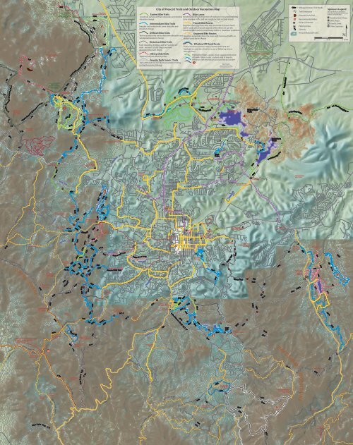
Granite Mountain Area<br />
~ About the Map ~<br />
This map production is made possible through a collaborative<br />
eort between the <strong>City</strong> <strong>of</strong> <strong>Prescott</strong> GIS Department &<br />
Trails Specialist, and the <strong>Prescott</strong> National Forest trails<br />
managers, along with support from local businesses;<br />
printing costs are paid for by the local business Sponsors<br />
that are shown to the left.<br />
The map features:<br />
Bike Routes (in orange) have been designated on city<br />
streets and may or may not be indicated by bike route<br />
signs. Riders share the road with vehicles.<br />
Bike lanes (in purple) have been designated on our city<br />
streets with striping and bike symbols. These lanes help<br />
riders move safely on the community’s busier streets.<br />
Two types <strong>of</strong> trails are highlighted on this side <strong>of</strong><br />
the map:<br />
Thumb Butte Area<br />
The <strong>City</strong> Trails range from the easy-cruising ample path <strong>of</strong><br />
the Peavine Trail along side Watson Lake to traversing the<br />
rocky ridges and outcrops in the Dells Scenic trails.<br />
Some <strong>City</strong> trailheads charge a parking fee (or get your<br />
annual parking pass at Parks and Rec 928-777-1122).<br />
All <strong>City</strong> Trails have detailed trail maps available on the <strong>City</strong><br />
website at http://prescott-az.gov/services/parks/trails<br />
There are many options for trail-based recreation in the<br />
<strong>Prescott</strong> National Forest. For additional information on<br />
<strong>Prescott</strong> National Forest hiking, riding, and bicycling<br />
opportunities, please visit the downtown oce at 344 S.<br />
Cortez or call (928) 443-8000. Note: Wednesdays are free<br />
parking day at Forest Service Trailheads.<br />
The Forest Service has detailed trail maps available for Lynx<br />
Lake area, Thumb Butte Area, and Granite Basin Area.<br />
EQUESTRIAN PARK<strong>IN</strong>G<br />
Cayuse Trailhead in Granite Basin is horse<br />
trailer friendly and intended to serve as the<br />
main horseback access to the basin. The<br />
Williamson Valley trailhead is horse trailer<br />
accessible. Additionally, the Trail 48 trailhead on Copper Basin<br />
Rd accommodates one horse trailer; parking is available o<br />
Thumb Butte Rd at Willow Springs Rd by the painted rock. The<br />
dirt lot just before the Goldwater Lake turno accommodates<br />
trailers. The Spruce Mountain 307 trailhead has ample parking<br />
and the Groom Creek Horse Camp also provides parking and<br />
trails for equestrian use.<br />
P<strong>IN</strong>ELAKES AND RIDGETOP LOOP/316 & 317 TRAILS<br />
distance: 3.1 miles<br />
access: Thumb Butte Park on Thumb Butte Rd<br />
parking: $5.00 fee Forest Service trailhead<br />
description: Start from Thumb Butte parking area on Trail 316<br />
as climbs through some technical sections to the junction with<br />
317, then begin your clockwise loop. You will be oered good<br />
views <strong>of</strong> the peaks as you descend on 317 along the ridgetop. As<br />
you approach the end <strong>of</strong> 317, trail 316 heads o to the right and<br />
begins the ascent back up a shady canyon to your starting point.<br />
There are many optional trail loops that can be combined with<br />
this trail loop.<br />
5900<br />
5800<br />
5700<br />
5600<br />
5500<br />
Whiskey 25/50 Area<br />
Whiskey 25 Loop (start & inish at Courthouse Plaza)<br />
~ <strong>City</strong> <strong>of</strong> <strong>Prescott</strong> Trails ~<br />
~ <strong>Prescott</strong> National Forest Trails ~<br />
9<br />
Ridgetop 317 & Pine Lakes 316 Trails Loop<br />
Sierra Prieta Overlook<br />
Trail etiquette is an<br />
important part <strong>of</strong> keeping<br />
our trails fun and safe for all<br />
trail users.<br />
~ Respect other users, expect<br />
other users<br />
~ Be friendly and courteous<br />
~ Share the trail. Ride, walk or run on<br />
the right, pass on the left<br />
~ Stay on trail.<br />
~ Bicyclists yield to runners, hikers,<br />
and horses. Bicyclists should stop to<br />
allow horses to pass safely.<br />
~ Downhill trac yield to uphill trac. When in<br />
doubt, yield.<br />
~ Use unpaved trails only when they are dry, not<br />
muddy or wet, to avoid leaving ruts or prints.<br />
~ Warn people when you are planning to pass<br />
~ Bicyclists anticipate other trail users around corners and<br />
control your speed through blind spots<br />
~ Equestrians clean up after your animal in developed sites<br />
~ Ride within your ability at all times<br />
<strong>Prescott</strong> Circle Trail<br />
DISCLAIMER This map was prepared<br />
only as a convenience to trail and<br />
route users.<br />
It does not in any way warrant the<br />
safety <strong>of</strong> the streets and trail facilities<br />
indicated on this map for use by the<br />
public. There is no guarantee <strong>of</strong> the<br />
accuracy <strong>of</strong> the information<br />
and the sponsors assume no liability<br />
for injuries arising out <strong>of</strong> use <strong>of</strong> this<br />
map or reliance on the information<br />
contained within. Route and trail users<br />
should use these routes only if he or<br />
she has the adequate skill level to do<br />
so, and that determination is to be<br />
made by the user. Trail and route users<br />
assume the risk to their own safety<br />
when using this map.<br />
PLEASANT ST<br />
6TH ST<br />
PLEASANT ST<br />
Library<br />
E SHELDON ST<br />
MAR<strong>IN</strong>A ST<br />
MAR<strong>IN</strong>A ST<br />
MAR<strong>IN</strong>A ST<br />
Elks Opera<br />
House<br />
Granite Creek<br />
Park<br />
<strong>City</strong> Hall<br />
CITY OF PRESCOTT<br />
Trails and Outdoor<br />
Recreation Map<br />
Bridge on Willow Loop Trail<br />
Granite Mountain in Background<br />
photo Chris Hosking<br />
The Circle Trail is a 50 mile non-motorized<br />
trail system that encompasses the <strong>City</strong> <strong>of</strong><br />
<strong>Prescott</strong>. Currently 35 miles have been<br />
completed.<br />
CORTEZ ST<br />
Yavapai<br />
County<br />
Courthouse<br />
GURLEY ST<br />
N<br />
CORTEZ ST<br />
CORTEZ ST<br />
g<br />
LEROUX ST<br />
AUBREY ST<br />
<strong>Prescott</strong><br />
National<br />
Forest<br />
Office<br />
CARLETON ST<br />
Post<br />
Office<br />
WILLIS ST<br />
MONTEZUMA ST<br />
GOODW<strong>IN</strong> ST<br />
g<br />
g<br />
g<br />
MONTEZUMA ST<br />
G<br />
F<br />
Whiskey Row<br />
G<br />
´<br />
Parking<br />
Garage<br />
Old<br />
Trestle<br />
Bridge<br />
= Bike Rack<br />
Mile High<br />
Middle<br />
School<br />
GRANITE ST<br />
GRANITE ST<br />
MADISON AVE<br />
COMFORT ST<br />
Greenways Trails<br />
g<br />
Granite<br />
Granite Creek<br />
Creek<br />
Sam Hill<br />
Warehouse<br />
(<strong>Prescott</strong><br />
College)<br />
F<br />
MC CORMICK ST<br />
Sharlot<br />
Hall<br />
Museum<br />
W SHELDON ST<br />
SONORA DR<br />
CAMPBELL ST<br />
Downtown Map<br />
1ST ST<br />
LEROUX ST<br />
MC CORMICK ST<br />
Arizona<br />
Pioneer’s<br />
Home<br />
BRIDGE ST<br />
´<br />
L<strong>IN</strong>COLN ST<br />
SUMMIT AVE<br />
PIONEER DR<br />
L<strong>IN</strong>COLN ST<br />
SUMMIT AVE<br />
GLEN WOOD AVE<br />
GROVE AVE<br />
x <strong>Prescott</strong><br />
College<br />
$1.00<br />
DAMERON DR