Full paper - Royal Botanic Gardens & Domain Trust - NSW ...
Full paper - Royal Botanic Gardens & Domain Trust - NSW ...
Full paper - Royal Botanic Gardens & Domain Trust - NSW ...

You also want an ePaper? Increase the reach of your titles
YUMPU automatically turns print PDFs into web optimized ePapers that Google loves.
340 Cunninghamia 12(4): 2012 Westbrooke, Gowans& Gibson, Vegetation of Paroo Darling National Park, western New South Wales<br />
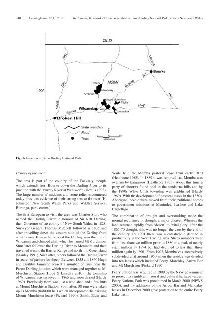
Fig. 1. Location of Paroo Darling National Park<br />
History of the area<br />
The area is part of the country of the Paakantyi people<br />
which extends from Bourke down the Darling River to its<br />
junction with the Murray River at Wentworth (Hercus 1993).<br />
The large number of middens and stone relics encountered<br />
today provides evidence of their strong ties to the river (H.<br />
Johnston, New South Wales Parks and Wildlife Service,<br />
Buronga, pers. comm.).<br />
The first European to visit the area was Charles Sturt who<br />
named the Darling River in honour of Sir Ralf Darling,<br />
then Governor of the colony of New South Wales, in 1828.<br />
Surveyor General Thomas Mitchell followed in 1835 and<br />
after travelling down the eastern side of the Darling from<br />
what is now Bourke he crossed the Darling near the site of<br />
Wilcannia and climbed a hill which he named Mt Murchison.<br />
Sturt later followed the Darling River to Menindee and then<br />
travelled west to the Barrier Range and north into Queensland<br />
(Stanley 1991). Soon after, others followed the Darling River<br />
in search of pasture for sheep. Between 1855 and 1860 Hugh<br />
and Bushby Jamieson leased a number of runs near the<br />
Paroo-Darling junction which were managed together as Mt<br />
Murchison Station (Hope & Linsday 2010). The township<br />
of Wilcannia was surveyed in 1865 and soon thrived (Hardy<br />
1969). Previously there was just a woolshed and a few huts<br />
at Mount Murchison Station. Soon after, 38 runs were taken<br />
up as Momba (848,000 ha.) which incorporated the existing<br />
Mount Murchison lease (Pickard 1990). Smith, Elder and<br />
Waite held the Momba pastoral lease from early 1870<br />
(Heathcote 1965). In 1889 it was reported that Momba was<br />
overrun by kangaroos (Heathcote 1965). About this time a<br />
party of shooters found opal in the sandstone hills and by<br />
the 1890s White Cliffs township was established (Hardy<br />
1969). With the development of pastoral leases in the 1850s,<br />
Aboriginal people were moved from their traditional homes<br />
to government missions at Menindee, Ivanhoe and Lake<br />
Cargelligo.<br />
The combination of drought and overstocking made the<br />
normal recurrence of drought a major disaster. Whereas the<br />
land returned rapidly from ‘desert’ to ‘vital glory’ after the<br />
1865-70 drought, this was no longer the case by the end of<br />
the century. By 1901 there was a catastrophic decline in<br />
productivity in the West Darling area. Sheep numbers went<br />
from less than two million prior to 1880 to a peak of nearly<br />
eight million by 1894 but had declined to less than three<br />
million again by 1901. From 1902, Momba was successively<br />
subdivided until around 1950 when the residue was divided<br />
into ten leases which included Peery, Mandalay, Arrow Bar<br />
and Mt Murchison (Pickard 1990).<br />
Peery Station was acquired in 1999 by the <strong>NSW</strong> government<br />
to protect its significant natural and cultural heritage values.<br />
Peery National Park was proclaimed in March 2000 (NPWS<br />
2000), and the additions of the Arrow Bar and Mandalay<br />
leases in December 2000 gave protection to the entire Peery<br />
Lake basin.