Full paper - Royal Botanic Gardens & Domain Trust - NSW ...
Full paper - Royal Botanic Gardens & Domain Trust - NSW ...
Full paper - Royal Botanic Gardens & Domain Trust - NSW ...

Create successful ePaper yourself
Turn your PDF publications into a flip-book with our unique Google optimized e-Paper software.
344 Cunninghamia 12(4): 2012 Westbrooke, Gowans& Gibson, Vegetation of Paroo Darling National Park, western New South Wales<br />
area is bounded to the north-west by the Darling River and<br />
includes around 40 km of Darling River frontage. The Wilga<br />
homestead and shearer’s quarters are situated on the southern<br />
bank of the Darling River just west of Papepapinbilla Creek.<br />
The Wilga study area falls within the Darling Riverine<br />
Plains bioregion. There are a number of ephemeral creeks<br />
(Talyawalka, Lake, Coopara and Papepapinbilla Creeks),<br />
channels and waterholes on the Darling River floodplain.<br />
These areas flow or fill for a short time following major<br />
rainfall events. The southern part of the study area takes in<br />
the northern extents of Poopelloe and Wongalara Lakes. Five<br />
named tanks (Dunlop, Bobs, Cuba, Corvale and Windia), a<br />
few unnamed tanks and four named bores (Yellow Waterhole,<br />
Salt, Coopra and Kooba) (Fig. 3) provided water for stock<br />
prior to the park being gazetted.<br />
Transect survey<br />
A preliminary survey to assess and map the vegetation<br />
communities present within the Mount Murchison and Wilga<br />
areas of Paroo Darling National Park was undertaken during<br />
June 2005, following three years of drought. A transect based<br />
sampling strategy was employed. Driven transects followed<br />
existing vehicle access tracks and fence lines, and additional<br />
walked transects were used to access more remote areas. All<br />
transects were tracked using a Global Positioning System<br />
(GPS) receiver in the Australian Map Grid projection (Zone<br />
54 and 55) and the 1984 World Geodetic System datum. The<br />
survey included approximately 335 km of transects (Fig. 3).<br />
Vegetation communities along these transects were recorded<br />
and dominant perennial species listed for each community.<br />
Details of how information was collected along these transect<br />
and used to define vegetation communities to produce a<br />
vegetation map at a scale of 1: 50,000 are outlined below.<br />
Quadrat survey<br />
A detailed floristic survey was undertaken during November<br />
2005 following good winter rainfall. A quadrat based sampling<br />
strategy was employed to survey the floristic composition<br />
of the vegetation communities. All quadrats were 900 m2<br />
(30 m x 30 m) in size. The sampling strategy was based on<br />
the preliminary vegetation map prepared following the June<br />
survey. Communities were generally sampled in proportion<br />
to the area they covered but to enable characterisation of<br />
communities, those of limited distribution may have been<br />
relatively over-sampled. All quadrat locations were recorded<br />
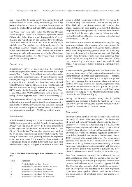
Table 2. Modified Braun-Blanquet scale (Kershaw & Looney<br />
1985)<br />
Scale Definition<br />
+ Few individuals, less than 1% cover<br />
1<br />
Any number of individuals, less than 5% cover<br />
2<br />
Any number of individuals, 6-25% cover<br />
3<br />
Any number of individuals, 26-50% cover<br />
4<br />
Any number of individuals, 51-75% cover<br />
5<br />
Any number of individuals, 76-100% cover<br />
using a Global Positioning System (GPS) receiver in the<br />
Australian Map Grid projection (Zone 54 and 55) and the<br />
1984 World Geodetic System datum. All vascular plant<br />
species occurring in each quadrat were recorded, identified<br />
to species level where possible and their conservation status<br />
determined. All flora were given a cover / abundance value,<br />
modified from Braun-Blanquet scale as cited in Kershaw and<br />
Looney (1985) (Table 2).<br />
The field survey was undertaken during early spring following<br />
good winter rains to take advantage of the opportunities for<br />
plant identification, particularly of grasses, herbs and forbs.<br />
Some later spring-flowering grasses, herbs and forbs may<br />
have been dormant at this time and not observed. Similarly,<br />
earlier spring-flowering plants may have completed their<br />
growth cycles and may not have been observed. Where<br />
dead material (e.g. leaves, stems, seeds) was available such<br />
species were recorded to family, genus or species level where<br />
possible.<br />
An estimate of the typical height and a visual estimate of the<br />
projected foliage cover of both native and introduced species<br />
in the tree layer, tall shrub layer (approximately > 1 m high),<br />
small shrub layer (approximately < 1 m high) and ground<br />
layer were recorded for each quadrat. Visual estimates of<br />
the total percentage cover of bare ground, cryptogams, litter,<br />
logs and rocks were recorded for each quadrat. All quadrats<br />
were photographed to provide a visual record. Forty seven<br />
quadrats were sampled for the Mount Murchison area and 55<br />
quadrats for the Wilga area (Fig. 4).<br />
During the November quadrat survey, the 1: 50,000<br />
vegetation map produced following the June field survey was<br />
verified by ground checking the mapped boundaries of the<br />
vegetation communities via driven transects.<br />
Data analysis<br />
Information from the transects was used in conjunction with<br />
the study of colour aerial photographs (The Department<br />
of Lands) and Landsat Thematic Mapper satellite imagery<br />
(Scene 95-83) to produce a vegetation map at 1: 50,000 scale.<br />
Vegetation mapping was undertaken using a combination of<br />
ArcGIS 9.0 and MapInfo Professional Version 7.5 Geographic<br />
Information Systems. The mapped vegetation communities<br />
were defined by floristic and structural characteristics (Specht<br />
1970) coupled with expert judgment. The communities<br />
proposed were related to those outlined in Benson (2006)<br />
to determine the equivalent vegetation community name and<br />
their conservation status. Most communities with patch sizes<br />
of a hectare or greater were mapped as polygons and those<br />
of restricted occurrence were located as points on the map.<br />
Data from quadrats were entered into a Microsoft ® Access<br />
2002 database. A species list was compiled for the study<br />
area incorporating all vascular plant species recorded from<br />
quadrats and additional species recorded opportunistically.<br />
The flora list also identifies which vegetation community<br />
each of the species was recorded in. For each vegetation<br />
community, mean species richness, total species richness<br />
and mean numbers of introduced species per quadrat were<br />
calculated.