River Basin Characteristics - Georgia Environmental Protection ...
River Basin Characteristics - Georgia Environmental Protection ...
River Basin Characteristics - Georgia Environmental Protection ...

You also want an ePaper? Increase the reach of your titles
YUMPU automatically turns print PDFs into web optimized ePapers that Google loves.
Section 2<br />
<strong>River</strong> <strong>Basin</strong> <strong>Characteristics</strong><br />
This section describes the following major characteristics of the Suwannee <strong>River</strong><br />
basin:<br />
In This Section<br />
<strong>River</strong> <strong>Basin</strong> Description<br />
Population and Land Use<br />
Local Governments and Planning Authorities<br />
Water Use Classifications<br />
• <strong>River</strong> basin description (Section 2.1): the physical features and natural processes<br />
of the basin.<br />
• Population and land use (Section 2.2): the sociological features of the basin,<br />
including the types of human activities that might affect water quality and water<br />
resource use.<br />
• Local governments and planning authorities (Section 2.3): identification and<br />
roles of the local authorities within the basin.<br />
• Water use classifications (Section 2.4): description of water use classifications<br />
and baseline goals for management of waters within the basin as defined in the<br />
state regulatory framework.<br />
2.1 <strong>River</strong> <strong>Basin</strong> Description<br />
This section describes the important geographical, geological, hydrological, and<br />
biological characteristics of the Suwannee <strong>River</strong> basin.<br />
The physical characteristics of the Suwannee <strong>River</strong> basin include its location,<br />
physiography, soils, climate, surface water and ground water resources, and natural water<br />
quality. These physical characteristics influence the basin’s biological habitats and the<br />
ways people use the basin’s land and water resources.<br />
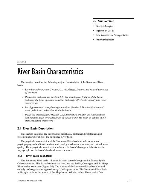
2.1.1 <strong>River</strong> <strong>Basin</strong> Boundaries<br />
The Suwannee <strong>River</strong> basin is located in south central <strong>Georgia</strong> and is flanked by the<br />
Ochlockonee and Flint <strong>River</strong> basins to the west, and the Satilla, Ocmulgee, and St. Marys<br />
<strong>River</strong> basins to the east (Figure 2-1). The portion of the Suwannee <strong>River</strong> basin located<br />
entirely in <strong>Georgia</strong> drains approximately 5,560 square miles. The Suwannee <strong>River</strong> <strong>Basin</strong><br />
in <strong>Georgia</strong> includes the waters of the Alapaha and Withlacoochee <strong>River</strong>s which flow<br />
Suwannee <strong>River</strong> <strong>Basin</strong> Plan 2–1
Section 2. <strong>River</strong> <strong>Basin</strong> <strong>Characteristics</strong><br />
50<br />
SCALE<br />
0 50<br />
GEORGIA<br />
OCHLOCKONEE<br />
Miles<br />
Figure 2-1. Location of the Suwannee <strong>River</strong> <strong>Basin</strong><br />
SUWANNEE<br />
SATILLA<br />
Portion of Suwannee within <strong>Georgia</strong><br />
Major <strong>River</strong>s<br />
State Boundaries<br />
Hydrologic Unit Boundaries<br />
FLORIDA<br />
2–2 Suwannee <strong>River</strong> <strong>Basin</strong> Plan<br />
N<br />
SAINT MARYS
south into Florida and join the Suwannee <strong>River</strong> which empties into the Gulf of Mexico.<br />
The Suwannee <strong>River</strong> basin drains approximately 10,000 square miles, with approximately<br />
5,560 square miles of the basin in <strong>Georgia</strong>.<br />
The U.S. Geological Survey (USGS) has divided the Suwannee <strong>River</strong> basin into four<br />
subbasins, or Hydrologic Unit Codes (HUCs; see Table 2-1). These HUCs are referred to<br />
repeatedly in this report to distinguish conditions in different parts of the Suwannee <strong>River</strong><br />
basin. Figure 2-2 shows the location of these subbasins and the associated counties within<br />
each subbasin.<br />
Table 2-1. Hydrologic Unit Codes (HUCs) of the Suwannee <strong>River</strong> <strong>Basin</strong> in <strong>Georgia</strong><br />
03110201 Suwannee <strong>River</strong><br />
03110202 Alapaha <strong>River</strong><br />
03110203 Withlacoochee <strong>River</strong><br />
03110204 Little <strong>River</strong><br />
2.1.2 Climate<br />
The Suwannee <strong>River</strong> basin is characterized by mild winters and hot summers. Mean<br />
annual precipitation ranges from 44 to 50 inches per year. Precipitation occurs as rainfall.<br />
Rainfall is fairly evenly distributed throughout the year, but a distinct dry season occurs<br />
from mid-summer to late fall. Rainfall is usually greatest in March and least in October.<br />
The mean annual temperature is about 66 degrees Fahrenheit (Journey and Atkins, 1996;<br />
citing Peck et al., 1992; Schneider et al., 1965; and Carter and Stiles, 1983).<br />
2.1.3 Physiography, Geology, Soils, and Hydrogeology<br />
Physiography<br />
The Ochlockonee, Satilla, St. Marys and Suwannee <strong>River</strong> basins lie entirely within the<br />
Coastal Plain physiographic province, which extends throughout the southeastern margin<br />
of the United States. The physiography of these river basins reflects a geologic history of<br />
repeated periods of land submergence which is typical of the Coastal Plain Province.<br />
These basins include all or portions of the Tifton Upland, the Okefenokee <strong>Basin</strong>, the<br />
Bacon Terraces and the Barrier Island Sequence districts of the Coastal Plain. The<br />
Ochlockonee <strong>River</strong> basin lies within the western third of the Tifton Upland District. The<br />
Satilla <strong>River</strong> basin lies entirely within the Bacon Terraces and Barrier Island Sequence<br />
districts. The St. Marys <strong>River</strong> basin lies entirely within the Okefenokee <strong>Basin</strong> and Barrier<br />
Island Sequence districts. The Suwannee <strong>River</strong> basin lies within the Tifton Upland and<br />
Okefenokee <strong>Basin</strong> districts.<br />
The Tifton Upland District is characterized by a well developed, extend dendritic<br />
stream pattern where narrow, rounded interfluves occur 50 to 200 feet above relatively<br />
narrow stream valley floors. The northwestern boundary of the district is the base of the<br />
Pelham Escarpment, which rises as much as 200 feet above the Dougherty Plain to the<br />
west. The Okefenokee <strong>Basin</strong> District is typified by very low topographic relief, numerous<br />
extensive swamps, and local sand ridges. The Bacon Terraces District displays a very<br />
extended, southeast trending dendritic drainage pattern containing ling, narrow<br />
interfluves with gently rounded to flat summits that are 50 to 100 feet above narrow,<br />
marshy floodplains. The district also contains several low, moderately dissected terraces<br />
which are generally parallel to the coastline. From west to east, these are designated the<br />
Hazlehurst, Pearson, Claxton, Argyle, Waycross and Penholoway terraces. The Barrier<br />
Island Sequence District is characterized by a series of prominent marine terraces which<br />
Section 2. <strong>River</strong> <strong>Basin</strong> <strong>Characteristics</strong><br />
Suwannee <strong>River</strong> <strong>Basin</strong> Plan 2–3
Section 2. <strong>River</strong> <strong>Basin</strong> <strong>Characteristics</strong><br />
HUC 03110204<br />
0<br />
0<br />
10<br />
10<br />
20<br />
DOOLY<br />
CRISP<br />
Moultrie<br />
THOMAS<br />
Cordele<br />
WORTH<br />
20<br />
30 KILOMETERS<br />
TURNER<br />
Tifton<br />
TIFT<br />
COLQUITT<br />
BROOKS<br />
30 MILES<br />
WILCOX<br />
HUC 03110202<br />
BEN HILL<br />
Figure 2-2. Hydrologic Units and Counties of the Suwannee <strong>River</strong> <strong>Basin</strong><br />
IRWIN<br />
BERRIEN<br />
COOK<br />
HUC 03110203<br />
LANIER<br />
LOWNDES<br />
Valdosta<br />
EXPLANATION<br />
Hydrologic Unit Boundary<br />
State Boundaries<br />
County Boundaries<br />
Cities with 1990 Populations<br />
greater than 10,000 within the basin<br />
2–4 Suwannee <strong>River</strong> <strong>Basin</strong> Plan<br />
COFFEE<br />
ATKINSON<br />
ECHOLS<br />
CLINCH<br />
Waycross<br />
WARE<br />
HUC 03110201<br />
CHARLTON<br />
BRANTLEY
form a step-like progression of decreasing altitudes toward the sea. The former, higher<br />
sea levels created barrier island-salt marsh environments parallel to and similar to those<br />
found on the present coast. The terraces are composed of sand ridges marking the former<br />
barrier islands, and are flanked by fresh water marshes at the former salt marsh locations.<br />
They have undergone slight to moderate dissection which is generally more advanced at<br />
the western edge of the district. Trail Ridge is the most prominent of these terraces with a<br />
maximum elevation of approximately 160 feet. It marks the western boundary of the<br />
Barrier Island Sequence District where it joins the Bacon Terraces and Okefenokee <strong>Basin</strong><br />
districts. Other, less prominent terraces in the district, from west to east, are the<br />
Wicomico, Penholoway, Talbot, Pamlico, Princess Anne, and Silver Bluff-Holocene<br />
terraces.<br />
The streams in these basins are typical of the Coastal Plain. They generally lack the<br />
riffles and shoals that are common to streams in the Piedmont Province to the north, and<br />
exhibit more extensive floodplain development and greater sinuosity.<br />
Carolina Bays are elliptical or “spoon-shaped” wetland depressions aligned roughly<br />
north-northwest and are logically well developed throughout the area east of the<br />
Suwannee <strong>River</strong> basin. Lime sinks and lake-filled sinks are well developed in areas<br />
underlain by limestone in the shallow subsurface, notably in the Lake Park area south and<br />
west of Valdosta, Lowndes County.<br />
Geology<br />
Weathered, poorly consolidated sediments underlie all of these river basins, and are<br />
dominantly composed of sands, clays, and gravels which range from Miocene to<br />
Holocene in age. These sediments include the Miccosukee Formation (Pliocene age),<br />
Altamaha Formation and various formations of the Hawthorne Group (all Miocene age),<br />
as well as barrier island and marsh/lagoon facies of the numerous shoreline complexes<br />
(Pleistocene to Holocene age). Local occurrences of calcareous sediments include the<br />
Suwannee Limestone (Oligocene age) and Duplin Marl (Pliocene age). Other rock types<br />
in the area include dolomite, chert, peat, phosphate and fuller’s earth, as well as<br />
Quaternary alluvium in the flood plains along the major stream valleys. Most of these<br />
sediments were deposited in either terrestrial or shallow marine environments.<br />
Sediments in the area are locally mined for construction sand and fill material. In<br />
addition, the Meigs Member of the Coosawhatchie Formation (Hawthorne Group) is the<br />
source of the economically important fuller’s earth clay deposits being mined in the<br />
Ochlockonee <strong>River</strong> <strong>Basin</strong>. In the past, crushed stone was produced from some of the<br />
limestone deposits, and a few of the larger Carolina Bays were mined for peat.<br />
Soils<br />
The Suwannee <strong>River</strong> <strong>Basin</strong> is within the Southern Coastal Plain and the Atlantic<br />
Coast Flatwoods Major Land Resource Areas (MLRA) (Figure 2-3). The soils within the<br />
river basin vary considerably, particularly from west to east across the area. The soils in<br />
this area can be combined into four major groups for discussion.<br />
The first group of soils covers the western portion of the river basin and is in the<br />
Southern Coastal Plain. This group is dominated by nearly level and very gently sloping<br />
Tifton and Dothan soils on uplands, and nearly level Osier, Pelham, Rains, and Alapaha<br />
soils along drainageways and floodplains. Tifton and Dothan are well drained upland<br />
soils that have a sandy surface layer and a yellowish brown or strong brown, loamy<br />
subsoil. The surface layer is normally loamy sand and is about 10 inches thick. The<br />
subsoil is mostly sandy clay loam. Characteristic of these soils is a layer of plinthite in the<br />
subsoil at a depth of about 30 inches. Plinthite is an iron-rich mixture of clay with quartz<br />
Section 2. <strong>River</strong> <strong>Basin</strong> <strong>Characteristics</strong><br />
Suwannee <strong>River</strong> <strong>Basin</strong> Plan 2–5
Section 2. <strong>River</strong> <strong>Basin</strong> <strong>Characteristics</strong><br />
0<br />
0<br />
10<br />
THOMAS<br />
10<br />
20<br />
DOOLY<br />
CRISP<br />
WORTH<br />
20<br />
30 KILOMETERS<br />
30 MILES<br />
WILCOX<br />
TURNER BEN HILL<br />
TIFT<br />
COLQUITT<br />
BROOKS<br />
COOK<br />
IRWIN<br />
BERRIEN<br />
LANIER<br />
LOWNDES<br />
Figure 2-3. Major Land Resource Areas in the Suwannee <strong>River</strong> <strong>Basin</strong><br />
EXPLANATION<br />
Southern Coastal Plain<br />
Carolina and <strong>Georgia</strong> Sand Hills<br />
Atlantic Coast Flatwoods<br />
Hydrologic Unit Boundary<br />
State Boundaries<br />
County Boundaries<br />
2–6 Suwannee <strong>River</strong> <strong>Basin</strong> Plan<br />
COFFEE<br />
ATKINSON<br />
ECHOLS<br />
CLINCH<br />
WARE<br />
Water<br />
CHARLTON<br />
BRANTLEY
and other constituents that can perch water during wet seasons. The soils along<br />
drainageways and floodplains are poorly drained. Most of these soils are sandy<br />
throughout, but some of them have a loamy subsoil at various depths. Water tables are<br />
commonly at or near the surface during wet seasons, and the soils are subject to flooding.<br />
The second group of soils are found at the transition between the Southern Coastal<br />
Plain and the Atlantic Coast Flatwoods MLRA's. This area contains soils some soils that<br />
are typical from both MLRA's, but it is dominated by nearly level, somewhat poorly<br />
drained and poorly drained soils, such as Leefield and Pelham. These soils have a sandy<br />
surface layer that is 20 to 40 inches thick over a loamy subsoil. Water tables range from<br />
near the surface to about 2.5 feet during wet seasons.<br />
The third major group of soils is in the Atlantic Coast Flatwoods MLRA. This area is<br />
dominated by nearly level, poorly drained soils on broad flats, and by very poorly drained<br />
soils in depressions and along drainageways. This area is characterized by an abundance<br />
of Spodosols, which are sandy soils that have a layer where a complex of organic matter<br />
and aluminum has accumulated. Most of the soils in this area are sandy, although a loamy<br />
subsoil is sometimes found at depth of around 3 feet. Water tables are commonly at or<br />
near the surface during wet seasons, and soils in depressions are often ponded.<br />
The fourth group of soils are also in the Atlantic Coast Flatwoods MLRA. These soils<br />
occur within the Okefenokee Swamp. This area is dominated by organic soils that are<br />
saturated and covered with water most of the time. These soils are extremely acid. They<br />
are normally underlain by sandy or loamy material at various depths. Scattered within the<br />
area of organic soils are islands of sandy mineral soils. These sandy soils are mostly<br />
poorly drained, with a water table at or near the surface during wet seasons, but they are<br />
higher in elevation and drier than the surrounding organic soils.<br />
Hydrogeology<br />
Coastal Plain sediments underlie the entire region and groundwater is produced from<br />
several aquifers. Sources of ground water include, in order of importance, the unconfined<br />
Surficial aquifer, the Upper and Lower Brunswick aquifers and the Upper and Lower<br />
Floridan aquifers. The Surficial aquifer is up to 230 feet thick and consists of<br />
interlayered, Miocene and younger, sand, clay and limestone. It is underlain by the Upper<br />
and Lower Brunswick aquifers both of which are composed of 150 and 70 feet,<br />
respectively, of poorly sorted sand. The Upper and Lower Floridan aquifers consist of<br />
Eocene to Oligocene carbonate rocks (largely limestone and dolostone) 700 to 2,500 feet<br />
in thickness. In each of the aquifers, except for the Surficial aquifer, the groundwater is<br />
under confined (aquifer) conditions. Most of these aquifers consistently have excellent<br />
water quality; however, the Lower Floridan aquifer is saline and generally does not meet<br />
drinking water standards.<br />
2.1.4 Surface Water Resources<br />
The major surface water resources of the Suwannee <strong>River</strong> basin are three major rivers,<br />
which drain portions of the basin. The eastern portion of the basin contains the<br />
headwaters for the Suwannee <strong>River</strong>. The central portion is drained by the Alapaha <strong>River</strong>,<br />
which joins the Suwannee <strong>River</strong> about 15 miles south of the stateline. The western<br />
portion of the basin comprises the Withlacoochee <strong>River</strong> watershed, which joins the<br />
Suwannee <strong>River</strong> about eight miles downstream from the confluence of the Suwannee and<br />
Alapaha rivers. The three major rivers thus cross the stateline separately, but they join<br />
long before the Suwannee reaches the Gulf of Mexico.<br />
Some of the major streams in the basin include the Little <strong>River</strong>, Alapacha <strong>River</strong>,<br />
Okapilco Creek, Suwanoochee <strong>River</strong>, Willacoochee <strong>River</strong> and Little <strong>River</strong>. Stream<br />
networks within each HUC are shown in Figures 2-4 through 2-7.<br />
Section 2. <strong>River</strong> <strong>Basin</strong> <strong>Characteristics</strong><br />
Suwannee <strong>River</strong> <strong>Basin</strong> Plan 2–7
Section 2. <strong>River</strong> <strong>Basin</strong> <strong>Characteristics</strong><br />
Figure 2-4. Hydrography, Suwannee <strong>River</strong> <strong>Basin</strong>, HUC 03110201<br />
0 10 20<br />
EXPLANATION<br />
Lake, Reservoir, or <strong>River</strong><br />
Hydrolography<br />
Hydrologic Unit Boundary<br />
County Boundaries<br />
0 10 20 30 KILOMETERS<br />
30 MILES<br />
2–8 Suwannee <strong>River</strong> <strong>Basin</strong> Plan
DOOLY<br />
CRISP<br />
TURNER<br />
TIFT<br />
WILCOX<br />
BEN HILL<br />
Figure 2-5. Hydrography, Suwannee <strong>River</strong> <strong>Basin</strong>, HUC 03110202<br />
0 10 20<br />
Section 2. <strong>River</strong> <strong>Basin</strong> <strong>Characteristics</strong><br />
EXPLANATION<br />
Lake, Reservoir, or <strong>River</strong><br />
Hydrolography<br />
Hydrologic Unit Boundary<br />
County Boundaries<br />
0 10 20 30 KILOMETERS<br />
30 MILES<br />
Suwannee <strong>River</strong> <strong>Basin</strong> Plan 2–9<br />
IRWIN<br />
COFFEE<br />
BERRIEN ATKINSON<br />
LOWNDES<br />
LANIER<br />
ECHOLS<br />
CLINCH
Section 2. <strong>River</strong> <strong>Basin</strong> <strong>Characteristics</strong><br />
WORTH<br />
THOMAS<br />
TIFT<br />
COLQUITT<br />
BROOKS<br />
COOK<br />
Figure 2-6. Hydrography, Suwannee <strong>River</strong> <strong>Basin</strong>, HUC 03110203<br />
BERRIEN<br />
LOWNDES<br />
0 10 20<br />
EXPLANATION<br />
LANIER<br />
Lake, Reservoir, or <strong>River</strong><br />
Hydrolography<br />
Hydrologic Unit Boundary<br />
County Boundaries<br />
0 10 20 30 KILOMETERS<br />
30 MILES<br />
2–10 Suwannee <strong>River</strong> <strong>Basin</strong> Plan
WORTH<br />
COLQUITT<br />
TURNER<br />
BROOKS<br />
Figure 2-7. Hydrography, Suwannee <strong>River</strong> <strong>Basin</strong>, HUC 03110204<br />
0 10 20<br />
Section 2. <strong>River</strong> <strong>Basin</strong> <strong>Characteristics</strong><br />
EXPLANATION<br />
Lake, Reservoir, or <strong>River</strong><br />
Hydrolography<br />
Hydrologic Unit Boundary<br />
County Boundaries<br />
0 10 20 30 KILOMETERS<br />
30 MILES<br />
Suwannee <strong>River</strong> <strong>Basin</strong> Plan 2–11<br />
TIFT<br />
COOK<br />
LOWNDES
Section 2. <strong>River</strong> <strong>Basin</strong> <strong>Characteristics</strong><br />
2.1.5 Ground Water Resources<br />
Groundwater resources in the Suwannee <strong>River</strong> basin are supplied by the Floridan<br />
aquifer system, one of the most productive ground water reservoirs in the United States.<br />
The system supplies about 50 percent of the ground water used in the state. It is used as a<br />
major water source throughout most of South <strong>Georgia</strong>. A more detailed description of the<br />
Floridan aquifer system is provided below.<br />
Floridan Aquifer<br />
The Floridan aquifer underlies the rest of the southern portion of the basin. The<br />
aquifer is overlain by approximately 25-125 feet of sandy clay residuum derived from<br />
chemical weathering of the underlying rock. The total thickness of the Floridan aquifer in<br />
the basin ranges from a few tens of feet in the north to more than 400 feet in the extreme<br />
southern portion of the basin. Clastic grains of sand and shale are major components of<br />
the Floridan aquifer near its northernmost extent, where it is dominantly limestone in the<br />
Ochlockonee basin. Throughout most of the basin, the aquifer can be divided into three<br />
thick limestone formations: the Tampa Limestone, the Suwannee Limestone and the<br />
Ocala Limestone. The Tampa Limestone consists of whitish gray limestone that has a<br />
shale bed at its base. This shale acts as a confining layer to the underlying Suwannee and<br />
Ocala limestones (Miller, 1986). Below the Tampa, the Suwannee limestone is a massive<br />
chalky unit that is easily dissolved and weathered. For this reason, the many solution<br />
cavities in the Tampa provide abundant water to the underlying Ocala Limestone. The<br />
Ocala Limestone is the principal unit of the Floridan aquifer, and contains an upper<br />
friable, porous unit and a lower fine-grained unit (Miller, 1986). This lower unit contains<br />
most of the groundwater in the Floridan aquifer (Torak and others, 1993). The Ocala is<br />
underlain by the clay-rich Lisbon Formation, which acts as a slower confining bed to the<br />
water-bearing limestones above. Well yields in the Floridan aquifer can range from about<br />
40 GPM in the north to more than 10,000 GPM in the thickest, southern most portion of<br />
the Floridan aquifer. The Floridan serves as the main aquifer from Decatur and Seminole<br />
counties to the coast.<br />
Recharge occurs through the sandy soil in the outcrop area. In the northern portion of<br />
the basin this unit is seen as one single aquifer and can be called either the Cretaceous<br />
Aquifer or the Dublin-Midville Aquifer. As you move to the south, an intervening clay<br />
layer becomes apparent, and divides the aquifer into two distinct units. Below is the<br />
Midville Aquifer of definite Cretaceous age. Overlying the confining shale unit is the<br />
Dublin Aquifer, which is of Cretaceous-Early Tertiary age.<br />
2.1.6 Biological Resources<br />
The Suwannee <strong>River</strong> basin supports a diverse and rich mix of terrestrial and aquatic<br />
habitats and is home to several federally and state-protected species. The basin<br />
encompasses parts of five major land resource areas. Some of the biological resources of<br />
the basin are summarized below.<br />
Fish Fauna<br />
The fish fauna of the <strong>Georgia</strong> portion of the Suwannee <strong>River</strong> basin includes 36<br />
species representing 13 families. The largest group of fish species found in the Suwannee<br />
basin are in the sunfish family Centrarchidae. Sunfish present in the Suwannee basin<br />
range from highly sought after game fish such as the largemouth bass, to rare species<br />
including the blackbanded sunfish. Other families with large numbers of species are the<br />
catfishes and the topminnows. Fish populations in the <strong>Georgia</strong> portion of the Suwannee<br />
basin are limited in productivity by acidic waters, low alkalinity, and extreme variation in<br />
flow.<br />
2–12 Suwannee <strong>River</strong> <strong>Basin</strong> Plan
Fisheries<br />
The headwaters of the Suwannee <strong>River</strong> drain approximately 574 square miles of the<br />
Okefenokee Swamp. The Suwannee <strong>River</strong> flows southwest through <strong>Georgia</strong> for 33 miles<br />
before entering Florida. Once in Florida, the Suwannee converges with two of its<br />
tributaries, the Alapaha and Withlacoochee rivers, which both originate in <strong>Georgia</strong>. The<br />
Suwannee <strong>River</strong> is a blackwater stream with extremely acidic waters. A pH reading of 3.6<br />
was recorded July 22, 1997 (U.S. Geological Survey, 1997).<br />
The Suwannee <strong>River</strong> basin possesses a diversity of aquatic habitats providing some<br />
unique fishing opportunities. The Okefenokee National Wildlife Refuge encompasses<br />
approximately 400,000 acres and contains several open water lakes within the<br />
Okefenokee Swamp. These lakes offer excellent fishing opportunities for chain pickerel,<br />
flier, warmouth, and bullhead catfish. Like the Okefenokee Swamp the Suwannee <strong>River</strong><br />
has good fisheries for flier, warmouth, chain pickerel, and bullhead catfishes.<br />
Banks Lake National Wildlife Refuge is located in Lanier County and contains 1,500<br />
acres of marsh, 1,549 acres of cypress swamp, and 1,000 acres of open water. Banks<br />
Lake is a natural pocosin or sink of ancient geological origin. This lake offers fishing<br />
opportunities for chain pickerel, warmouth, largemouth bass, bluegill, and crappie.<br />
The Alapaha <strong>River</strong> is a small blackwater river which originates in Crisp and Wilcox<br />
counties. With the exception of high flow periods, travel by boat on the Alapaha is<br />
limited to the section of the river below the northern boundary of Berrien County. This<br />
river has good fisheries for largemouth bass, redbreast sunfish, bluegill, warmouth,<br />
crappie, and catfishes. The rare Suwannee bass is also found in the Alapaha <strong>River</strong>.<br />
The Withlacoochee <strong>River</strong> is the only river in the <strong>Georgia</strong> portion of the Suwannee<br />
drainage that is not a typical blackwater stream. This river is largely characterized by<br />
steep limestone banks and rocky shoals. During moderate to low flows the Withlacoochee<br />
is predominately a spring-fed river. However, during high flow periods this river is<br />
influenced by swamp drainage and assumes a blackwater appearance. This river provides<br />
good fishing opportunities for largemouth bass, redbreast sunfish, warmouth, bluegill,<br />
crappie, catfishes, and the Suwannee bass.<br />
The banded topminnow, blackbanded sunfish, and Suwannee bass are three fish<br />
species found in the Suwannee basin that are currently listed by the state as rare species.<br />
The banded topminnow and blackbanded sunfish are found in the Suwannee <strong>River</strong>. The<br />
Suwannee bass is found in both the Alapaha and Withlacoochee rivers.<br />
2.2 Population and Land Use<br />
2.2.1 Population<br />
As of 1995, about 231,000 people lived in the Suwannee watershed (DRI/McGraw-<br />
Hill, 1996). Population distribution in the basin at the time of the 1990 census by census<br />
blocks is shown in Figure 2-8. Population centers in the Suwannee watershed include the<br />
development surrounding Valdosta, Tifton, Moultrie and Fitzgerald.<br />
Between 1975 and 1995, the population in the Suwannee <strong>River</strong> basin increased by 1.3<br />
percent per year (DRI/McGraw-Hill, 1996). <strong>Basin</strong> population is projected to increase at<br />
an average growth rate through 2050.<br />
One area in which this river basin will differ slightly from state trends, is an age group<br />
of 16-24 year olds which will experience above average growth through 2050. The river<br />
basin will mirror state trends in terms of its elderly population with the 65 and older age<br />
Section 2. <strong>River</strong> <strong>Basin</strong> <strong>Characteristics</strong><br />
Suwannee <strong>River</strong> <strong>Basin</strong> Plan 2–13
Section 2. <strong>River</strong> <strong>Basin</strong> <strong>Characteristics</strong><br />
0<br />
0<br />
10<br />
10<br />
20<br />
DOOLY<br />
CRISP<br />
WORTH<br />
COLQUITT<br />
THOMAS<br />
20<br />
30 KILOMETERS<br />
30 MILES<br />
WILCOX<br />
BEN HILL<br />
EXPLANATION<br />
Less than 25<br />
Hydrologic Unit Boundary<br />
State Boundaries<br />
County Boundaries<br />
Figure 2-8. Population Density in the Suwannee <strong>River</strong> <strong>Basin</strong> (persons per square mile)<br />
2–14 Suwannee <strong>River</strong> <strong>Basin</strong> Plan<br />
COFFEE<br />
ATKINSON<br />
WARE<br />
25 - 49<br />
50 - 100<br />
100 - 200<br />
200 - 400<br />
400 - 800<br />
800 - 1600<br />
Greater than 1600<br />
BRANTLEY<br />
CHARLTON
group showing a larger than average gain through 2050. Large youth and elderly<br />
populations will mean a decline in the working age population.<br />
2.2.2 Employment<br />
The Suwannee <strong>River</strong> basin supported 87,100 jobs in 1995. It is moving from a<br />
manufacturing- to a service-based economy. In the coming years, a decrease in jobs is<br />
expected in manufacturing and durable goods, offset by an increase in jobs in the service<br />
and trade sectors.<br />
2.2.3 Land Cover and Use<br />
Land use/land cover classification (Figures 2-9 through 2-16) was determined for the<br />
Suwannee <strong>River</strong> <strong>Basin</strong> based on high-altitude aerial photography for 1972-76 (U.S.<br />
Geological Survey, 1972-78). Subsequently in 1991 land cover data were developed<br />
based on interpretation of Landsat TM satellite image data obtained during 1988-90, leafoff<br />
conditions. These two coverages differ significantly. Aerial photography allows<br />
identification of both land cover and land uses. Satellite imagery, however, detects<br />
primarily land cover, and not land use, such that a forest and a wooded subdivision may,<br />
for instance, appear similar. Satellite interpretation also tends to be less accurate than<br />
aerial photography.<br />
The 1988-90 land cover interpretation showed 41 percent of the basin in forest cover,<br />
20 percent in wetlands, 1 percent in urban land cover, and 30 percent in agriculture<br />
(Figures 2-13 through 2-16). Statistics for 15 landcover classes in the <strong>Georgia</strong> portion of<br />
the Suwannee <strong>River</strong> basin for the 1988-90 coverage are presented in Table 2-2 (GA<br />
DNR, 1996).<br />
Table 2-2. Land Cover Statistics for the Suwannee <strong>Basin</strong><br />
Class Name % Acres<br />
Open Water 0.7 24,321.5<br />
Clear Cut/Young Pine 7.3 260,783.4<br />
Pasture 8.0 289,022.3<br />
Cultivated/Exposed Earth 21.7 779,758.0<br />
Low Density Urban 0.9 32,205.8<br />
High Density Urban 0.4 12,548.3<br />
Emergent Wetland 3.7 133,275.1<br />
Scrub/Shrub Wetland 3.5 126,395.4<br />
Forested Wetland 12.6 453,486.7<br />
Coniferous Forest 16.7 601,469.0<br />
Mixed Forest 20.4 732,923.1<br />
Hardwood Forest 3.7 134,164.9<br />
Salt Marsh 0.0 0.9<br />
Brackish Marsh 0.0 0.0<br />
Tidal Flats/Beaches 0.0 0.0<br />
Total 100.0 3,598,580.0<br />
Forestry<br />
Forestry is a major part of the economy within the basin. Markets for forest products<br />
afford landowners excellent investment opportunities to manage and sell their timber,<br />
pine straw, naval stores, etc., products. Statewide, the forest industry output for 1997<br />
grew to approximately $19.5 billion dollars. The value added by this production, which<br />
includes wages, profits, interest, rent, depreciation and taxes paid into the economy<br />
reached a record high $9.3 billion dollars. <strong>Georgia</strong>ns are benefited directly by 177,000<br />
Section 2. <strong>River</strong> <strong>Basin</strong> <strong>Characteristics</strong><br />
Suwannee <strong>River</strong> <strong>Basin</strong> Plan 2–15
Section 2. <strong>River</strong> <strong>Basin</strong> <strong>Characteristics</strong><br />
EXPLANATION<br />
Urban or Built-up Land<br />
Agricultural Land<br />
Rangeland<br />
Forest Land<br />
Barren Land<br />
Hydrologic Unit Boundary<br />
County Boundaries<br />
0 10 20<br />
0 10 20 30 KILOMETERS<br />
30 MILES<br />
Figure 2-9. Land Use, Suwannee <strong>River</strong> <strong>Basin</strong>, HUC 03110201, USGS 1972-76 Classification Updated with<br />
1990 Urban Areas<br />
2–16 Suwannee <strong>River</strong> <strong>Basin</strong> Plan<br />
Water<br />
Wetland
0 10 20<br />
Section 2. <strong>River</strong> <strong>Basin</strong> <strong>Characteristics</strong><br />
EXPLANATION<br />
Urban or Built-up Land<br />
Agricultural Land<br />
Rangeland<br />
Forest Land<br />
Barren Land<br />
Hydrologic Unit Boundary<br />
County Boundaries<br />
Figure 2-10. Land Use, Suwannee <strong>River</strong> <strong>Basin</strong>, HUC 03110202, USGS 1972-76 Classification Updated with<br />
1990 Urban Areas<br />
Suwannee <strong>River</strong> <strong>Basin</strong> Plan 2–17<br />
Water<br />
Wetland<br />
0 10 20 30 KILOMETERS<br />
30 MILES
Section 2. <strong>River</strong> <strong>Basin</strong> <strong>Characteristics</strong><br />
THOMAS<br />
WORTH<br />
TIFT<br />
COLQUITT<br />
BROOKS<br />
COOK<br />
BERRIEN<br />
LOWNDES<br />
EXPLANATION<br />
LANIER<br />
0 10 20<br />
Urban or Built-up Land<br />
Agricultural Land<br />
Rangeland<br />
Forest Land<br />
Barren Land<br />
Hydrologic Unit Boundary<br />
County Boundaries<br />
Figure 2-11. Land Use, Suwannee <strong>River</strong> <strong>Basin</strong>, HUC 03110203, USGS 1972-76 Classification Updated with<br />
1990 Urban Areas<br />
2–18 Suwannee <strong>River</strong> <strong>Basin</strong> Plan<br />
Water<br />
Wetland<br />
0 10 20 30 KILOMETERS<br />
30 MILES
WORTH<br />
COLQUITT<br />
TURNER<br />
BROOKS<br />
0 10 20<br />
Section 2. <strong>River</strong> <strong>Basin</strong> <strong>Characteristics</strong><br />
EXPLANATION<br />
Urban or Built-up Land<br />
Agricultural Land<br />
Rangeland<br />
Forest Land<br />
Barren Land<br />
Hydrologic Unit Boundary<br />
County Boundaries<br />
Figure 2-12. Land Use, Suwannee <strong>River</strong> <strong>Basin</strong>, HUC 03110204, USGS 1972-76 Classification Updated with<br />
1990 Urban Areas<br />
Suwannee <strong>River</strong> <strong>Basin</strong> Plan 2–19<br />
TIFT<br />
COOK<br />
LOWNDES<br />
Water<br />
Wetland<br />
0 10 20 30 KILOMETERS<br />
30 MILES
Section 2. <strong>River</strong> <strong>Basin</strong> <strong>Characteristics</strong><br />
EXPLANATION<br />
Open Water<br />
Clear Cut / Young Pine<br />
Cultivated / Exposed Earth<br />
Low Density Urban<br />
Emergent Wetland<br />
Figure 2-13. Land Cover 1990, Suwannee <strong>River</strong> <strong>Basin</strong>, HUC 03110201<br />
0 10 20<br />
Hydrologic Unit Boundary<br />
County Boundaries<br />
0 10 20 30 KILOMETERS<br />
30 MILES<br />
2–20 Suwannee <strong>River</strong> <strong>Basin</strong> Plan<br />
Pasture<br />
High Density Urban<br />
Scrub / Shrub Wetland<br />
Forested Wetland<br />
Coniferous Forest<br />
Mixed Forest<br />
Hardwood Forest
Figure 2-14. Land Cover 1990, Suwannee <strong>River</strong> <strong>Basin</strong>, HUC 03110202<br />
0 10 20<br />
Section 2. <strong>River</strong> <strong>Basin</strong> <strong>Characteristics</strong><br />
EXPLANATION<br />
Open Water<br />
Clear Cut / Young Pine<br />
Cultivated / Exposed Earth<br />
Low Density Urban<br />
Emergent Wetland<br />
Suwannee <strong>River</strong> <strong>Basin</strong> Plan 2–21<br />
Pasture<br />
High Density Urban<br />
Scrub / Shrub Wetland<br />
Forested Wetland<br />
Coniferous Forest<br />
Mixed Forest<br />
Hardwood Forest<br />
Hydrologic Unit Boundary<br />
County Boundaries<br />
0 10 20 30 KILOMETERS<br />
30 MILES
Section 2. <strong>River</strong> <strong>Basin</strong> <strong>Characteristics</strong><br />
WORTH<br />
THOMAS<br />
TIFT<br />
COLQUITT<br />
BROOKS<br />
COOK<br />
Figure 2-15. Land Cover 1990, Suwannee <strong>River</strong> <strong>Basin</strong>, HUC 03110203<br />
BERRIEN<br />
LOWNDES<br />
LANIER<br />
0 10 20<br />
EXPLANATION<br />
Open Water<br />
Clear Cut / Young Pine<br />
Cultivated / Exposed Earth<br />
Low Density Urban<br />
Emergent Wetland<br />
2–22 Suwannee <strong>River</strong> <strong>Basin</strong> Plan<br />
Pasture<br />
High Density Urban<br />
Scrub / Shrub Wetland<br />
Forested Wetland<br />
Coniferous Forest<br />
Mixed Forest<br />
Hardwood Forest<br />
Hydrologic Unit Boundary<br />
County Boundaries<br />
0 10 20 30 KILOMETERS<br />
30 MILES
WORTH<br />
COLQUITT<br />
BROOKS<br />
TURNER<br />
Figure 2-16. Land Cover 1990, Suwannee <strong>River</strong> <strong>Basin</strong>, HUC 03110204<br />
Section 2. <strong>River</strong> <strong>Basin</strong> <strong>Characteristics</strong><br />
EXPLANATION<br />
Open Water<br />
Clear Cut / Young Pine<br />
Cultivated / Exposed Earth<br />
Low Density Urban<br />
Emergent Wetland<br />
Suwannee <strong>River</strong> <strong>Basin</strong> Plan 2–23<br />
TIFT<br />
COOK<br />
LOWNDES<br />
0 10 20<br />
Pasture<br />
High Density Urban<br />
Scrub / Shrub Wetland<br />
Forested Wetland<br />
Coniferous Forest<br />
Mixed Forest<br />
Hardwood Forest<br />
Hydrologic Unit Boundary<br />
County Boundaries<br />
0 10 20 30 KILOMETERS<br />
30 MILES
Section 2. <strong>River</strong> <strong>Basin</strong> <strong>Characteristics</strong><br />
job opportunities created by the manufacture of paper, lumber, furniture and various other<br />
wood products as well as benefiting the consumers of these products. Other benefits of<br />
the forest include hunting, fishing, aesthetics, wildlife watching, hiking, camping and<br />
other recreational opportunities as well as providing important environmental benefits<br />
such as clean air and water and wildlife habitat.<br />
According to the US Forest Service’s Forest Statistics for <strong>Georgia</strong>, 1997 report<br />
(Thompson, 1997), there is approximately 3,429,000 acres of commercial forestland for<br />
the entire counties within the basin. Approximately 62 percent of the total land area is<br />
commercial forest. Private landowners account for 64 percent of the commercial forest<br />
ownership while the forest industry companies account for 33 percent. Governmental<br />
entities account for about 3 percent of the forestland. Forestry acreage in the Suwannee<br />
<strong>River</strong> basin is summarized in Table 2-3. Figure 2-17 depicts silvicultural land use in the<br />
Suwannee basin.<br />
Table 2-3. Forestry Acreage in the Suwannee <strong>River</strong> <strong>Basin</strong><br />
County<br />
Commercial<br />
Forest<br />
Pine Oak-pine<br />
Upland<br />
Hardwood<br />
Lowland<br />
Hardwood<br />
Atkinson 169,900 94,500 11,300 10,600 42,200<br />
Ben Hill 109,500 67,200 16,800 2,300 15,200<br />
Berrien 179,600 90,100 16,300 3,200 64,600<br />
Brooks 189,300 58,900 28,300 30,700 69,300<br />
Charlton 307,100 202,000 41,200 7,300 38,400<br />
Clinch 469,100 309,600 36,400 0 108,400<br />
Colquitt 168,800 81,200 28,900 6,700 36,500<br />
Cook 78,500 30,800 11,300 7,800 27,500<br />
Crisp 68,500 14,700 12,400 7,600 30,000<br />
Echols 242,600 129,800 22,200 7,000 79,400<br />
Irwin 117,500 58,600 24,300 9,500 25,100<br />
Lanier 91,700 48,100 3,700 1,000 35,400<br />
Lowndes 211,900 79,400 35,400 33,500 52,200<br />
Thomas 187,000 68,900 61,900 23,200 33,100<br />
Tift 55,900 19,000 6,300 8,700 20,900<br />
Turner 91,300 53,900 5,400 6,300 16,300<br />
Ware 345,100 228,700 32,400 0 66,400<br />
Wilcox 151,700 87,400 11,300 5,600 40,000<br />
Worth 194,000 94,300 37,600 10,300 44,500<br />
Total 3,429,000 1,817,100 443,400 181,300 845,400<br />
For the period from 1982 to 1997, for the entire counties within the basin, the area<br />
classified as commercial forestland increased approximately 5 percent. The area<br />
classified as pine type decreased approximately 6 percent. The area classified as oak-pine<br />
type increased approximately 55 percent. The area classified as upland hardwood<br />
decreased approximately 21 percent. The area classified as bottomland hardwood<br />
increased approximately 3 percent. Approximately 141,700 acres were classified as nonstocked.<br />
Agriculture<br />
Agriculture is a significant part of the Suwannee <strong>River</strong> <strong>Basin</strong>’s ecosystem. In fact,<br />
agriculture accounts for almost 29 percent of the land use in the basin.<br />
2–24 Suwannee <strong>River</strong> <strong>Basin</strong> Plan
0<br />
0<br />
10<br />
10<br />
20<br />
20<br />
30 KILOMETERS<br />
30 MILES<br />
Figure 2-17. Silvicultural Land in the Suwannee <strong>River</strong> <strong>Basin</strong><br />
EXPLANATION<br />
Section 2. <strong>River</strong> <strong>Basin</strong> <strong>Characteristics</strong><br />
30 to 50 percent of county in timber land<br />
50 to 70 percent of county in timber land<br />
70 to 90 percent of county in timber land<br />
Greater than 90 percent of county in timber land<br />
Hydrologic Unit Boundary<br />
State Boundaries<br />
County Boundaries<br />
Suwannee <strong>River</strong> <strong>Basin</strong> Plan 2–25
Section 2. <strong>River</strong> <strong>Basin</strong> <strong>Characteristics</strong><br />
In 1997, there were some 1,040,286 acres devoted to agricultural production (Figure 2-<br />
18). All major commodities that are grown in <strong>Georgia</strong> (peanuts, corn, cotton, oats, rye,<br />
sorghum, soybeans, and tobacco) are produced in the <strong>Basin</strong>. Worth County is the basins<br />
top peanut producing county and ranks 3 rd among all counties in the State. Irwin County<br />
leads the <strong>Basin</strong> in corn production (6 th in <strong>Georgia</strong>). With respect to cotton and tobacco<br />
production the Suwannee <strong>River</strong> <strong>Basin</strong> is home to seven of the State’s top cotton<br />
producing counties and six of the top tobacco producing counties.<br />
Orchard production is also significant in the area. In fact, Brooks County is <strong>Georgia</strong>’s<br />
second most productive county for peaches; while Colquitt County also ranks in the top<br />
ten counties. Berrien and Thomas Counties contain significant pecan production areas.<br />
Additionally, the <strong>Basin</strong> has a strong vegetable production market with Crisp County<br />
considered Watermelon Capitol of the World.<br />
<strong>Georgia</strong>’s irrigation permit database shows 4,924 irrigation permits have been issued<br />
for the purpose of agricultural irrigation in the Suwannee <strong>River</strong> <strong>Basin</strong>. Commodity<br />
producers, in the counties that comprise the <strong>Basin</strong>, applied some 195.03 million gallons<br />
of water per day for supplemental irrigation. As a result, producers applied an average of<br />
8.9 inches per acre during 1995. A majority of agricultural water use for irrigation came<br />
from groundwater sources, some 63 percent, in 1995. Berrien, Tift, and Turner Counties<br />
contain the largest number of irrigated acreage in the <strong>Basin</strong>.<br />
In addition to commodity production, the Suwannee <strong>River</strong> <strong>Basin</strong> has an intensive<br />
animal industry as well. Table 2-4 shows number of animals by sector within the animal<br />
agricultural industry in the <strong>Basin</strong>. Brooks and Colquitt Counties rank among the State’s<br />
top ten counties in three areas—number of cattle on farm, with milk production through<br />
number of dairy cattle on farm, and number of hogs and pigs. Poultry production is<br />
present, and growing, in the <strong>Basin</strong> due to new hatcheries and processing plants near<br />
Camilla.<br />
Table 2-4. Agricultural Operations in the Suwannee <strong>River</strong> <strong>Basin</strong> (data supplied by NRCS)<br />
Watershed Watershed Watershed Watershed Suwannee<br />
Element<br />
3110201 3110202 3110203 3110204 <strong>Basin</strong> Total<br />
Acres 37667 347905 289240 229869 904681<br />
Dairy Cattle (Head<br />
1997)<br />
389 501 2351 1043 4283<br />
All Cattle and Calves<br />
(Head 1997)<br />
5476 40671 37876 30372 114396<br />
Hogs and Pigs<br />
(Head 1996)<br />
2801 28522 53822 39668 124824<br />
Boilers (thousands,<br />
1997)<br />
2486005 15314946 2804340 5878195 26483486<br />
Layers (thousands,<br />
1997)<br />
168401 9827 0 0 178229<br />
Irrigated Acres<br />
(1995)<br />
2969 80408 55079 51429 189884<br />
Total Agriculture<br />
Acres (1989-1997)<br />
43378 392296 341197 263415 1040286<br />
2–26 Suwannee <strong>River</strong> <strong>Basin</strong> Plan
0<br />
0<br />
10<br />
10<br />
20<br />
20<br />
30 KILOMETERS<br />
30 MILES<br />
Figure 2-18. Agricultural Land in the Suwannee <strong>River</strong> <strong>Basin</strong><br />
EXPLANATION<br />
Section 2. <strong>River</strong> <strong>Basin</strong> <strong>Characteristics</strong><br />
Less than 15 percent of county in farmland<br />
15 to 25 percent of county in farmland<br />
25 to 35 percent of county in farmland<br />
Greater than 35 percent of county in farmland<br />
Hydrologic Unit Boundary<br />
State Boundaries<br />
County Boundaries<br />
Suwannee <strong>River</strong> <strong>Basin</strong> Plan 2–27
Section 2. <strong>River</strong> <strong>Basin</strong> <strong>Characteristics</strong><br />
Collectively, across all animal operations, there are an estimated 203,221 Animal<br />
Units (AUs) in the <strong>Basin</strong>. AUs are defined here as 1000 lb. Animal Equivalents. Animal<br />
operations, in the counties that comprise the <strong>Basin</strong>, used some 3.75 million gallons of<br />
water per day in 1995. Additionally, some 2.5 million tons per year of animal waste was<br />
generated on these operations. Producers handle animal waste through various<br />
management activities that utilize nutrients, and other soil amendment benefits, for<br />
commodity production.<br />
Agriculture is a key component of the Ochlocknee <strong>River</strong> <strong>Basin</strong>’s economy. In 1997,<br />
agriculture contributed over $4 billion to the local economy. Along with significant<br />
agricultural production, however, comes an increased potential for agricultural non-point<br />
source pollution. As a part of the river basin planning process, the <strong>Georgia</strong> Soil and<br />
Water Conservation Commission (GSWCC)—with technical assistance from the Natural<br />
Resources Conservation Service (NRCS)—assess agricultural impacts on water quantity<br />
and water quality. Historical, present, and future agricultural water demand is assessed in<br />
Section 3; while agricultural non-point source pollution is assessed in Section 4.<br />
2.3 Local Governments and Planning Authorities<br />
Many aspects of basin management and water quality protection depend on decisions<br />
regarding zoning, land use, and land management practices. These are particularly<br />
important for the control of nonpoint pollutionCpollution that arises in storm water<br />
runoff from agriculture, urban or residential development, and other land uses. The<br />
authority and responsibility for planning and control of these factors lies with local<br />
governments, making local governments and jurisdictions important partners in basin<br />
management.<br />
The Department of Community Affairs (DCA) is the state’s principal department with<br />
responsibilities for implementing the coordinated planning process established by the<br />
<strong>Georgia</strong> Planning Act. Its responsibilities include promulgation of minimum standards for<br />
preparation and implementation of plans by local governments, review of local and<br />
regional plans, certification of qualified local governments, development of a state plan,<br />
and provision of technical assistance to local governments. Activities under the Planning<br />
Act are coordinated with the <strong>Environmental</strong> <strong>Protection</strong> Division (EPD), Regional<br />
Development Centers (RDCs), and local governments.<br />
2.3.1 Counties and Municipalities<br />
Local governments in <strong>Georgia</strong> consist of counties and incorporated municipalities. As<br />
entities with constitutional responsibility for land management, local governments have a<br />
significant role in the management and protection of water quality. The role of local<br />
governments includes enacting and enforcing zoning, storm water and development<br />
ordinances; undertaking water supply and wastewater treatment planning; and<br />
participating in programs to protect wellheads and significant ground water recharge<br />
areas. Many local governments are also responsible for operation of water supply and<br />
wastewater treatment facilities.<br />
The Suwannee <strong>River</strong> basin includes part or all of 20 <strong>Georgia</strong> counties (Table 2-5 and<br />
Figure 2-2); however, only six are entirely within the basin, and three counties have a<br />
small fraction (
Table 2-5. <strong>Georgia</strong> Counties in the Suwannee <strong>River</strong> <strong>Basin</strong><br />
Counties Entirely Within the<br />
Suwannee <strong>River</strong> <strong>Basin</strong><br />
Tift, Berrien, Cook, Lanier,<br />
Lowndes, Echols<br />
Counties Partially Within the<br />
Suwannee <strong>River</strong> <strong>Basin</strong><br />
Clinch, Charlton, Ware, Atkinson, Irwin,<br />
Wilcox, Crisp, Turner, Worth, Colquitt,<br />
Brooks<br />
Table 2-6. <strong>Georgia</strong> Municipalities in the Suwannee <strong>River</strong> <strong>Basin</strong><br />
HUC 03110201<br />
Argyle<br />
Cogdell<br />
Council<br />
Dupont<br />
HUC 03110202<br />
Abba<br />
Alapaha<br />
Amboy<br />
Bannockburn<br />
Chula<br />
Dakota<br />
HUC 03110203<br />
Adel<br />
Baden<br />
Barretts<br />
Barwick<br />
Berlin<br />
HUC 03110204<br />
Cloverdale<br />
Shingler<br />
Sylvester<br />
Edith<br />
Fargo<br />
Fruitland<br />
Haylow<br />
Dasher<br />
Double Run<br />
Fitzerald<br />
Harding<br />
Hatley<br />
Howell<br />
Brookfield<br />
Cecil<br />
Clyattville<br />
Dixie<br />
Enigma<br />
Sumner<br />
Poulan<br />
TyTy<br />
Homerville<br />
Manor<br />
Needmore<br />
Potter<br />
Irwinville<br />
Lake Park<br />
Lakeland<br />
Mayday<br />
Myustic<br />
Naylor<br />
Fender<br />
Kinderlou<br />
Laconte<br />
Lenox<br />
Moultrie<br />
Omega<br />
Crosland<br />
Norman Park<br />
Racepond<br />
Sirmans<br />
Thelma<br />
Withers<br />
Ocilla<br />
Pitts<br />
Rebecca<br />
Rochelle<br />
Seville<br />
Staterville<br />
Nankin<br />
Nashville<br />
Ousley<br />
Pavo<br />
Quitman<br />
Ellenton<br />
Barney<br />
Morven<br />
Section 2. <strong>River</strong> <strong>Basin</strong> <strong>Characteristics</strong><br />
Counties With Less Than 20%<br />
Area Within the <strong>Basin</strong><br />
Thomas, Coffee, Ben Hill<br />
2.3.2 Regional Development Centers<br />
Regional Development Centers (RDCs) are agencies of local governments, with<br />
memberships consisting of all the cities and counties within each RDC’s territorial area.<br />
There are currently 17 RDCs in <strong>Georgia</strong>. RDCs facilitate coordinated and comprehensive<br />
planning at local and regional levels, assist their member governments with conformity to<br />
minimum standards and procedures, and can have a key role in promoting and supporting<br />
management of urban runoff, including watershed management initiatives. RDCs also<br />
serve as liaisons with state and federal agencies for local governments in each region.<br />
Funding sources include members’ dues and funds available through DCA. Table 2-7<br />
summarizes the RDCs and the associated counties within the Suwannee <strong>River</strong> basin.<br />
Stockton<br />
Twin Lakes<br />
Valdosta<br />
Weber<br />
Westwood<br />
Worth<br />
Ray City<br />
Sparks<br />
Tifton<br />
Unionville<br />
Hahira<br />
Suwannee <strong>River</strong> <strong>Basin</strong> Plan 2–29
Section 2. <strong>River</strong> <strong>Basin</strong> <strong>Characteristics</strong><br />
Table 2-7. Regional Development Centers in the Suwannee <strong>River</strong> <strong>Basin</strong><br />
Regional Development Center Member Counties with Land Area in the Suwannee <strong>Basin</strong><br />
Southwest <strong>Georgia</strong> Colquitt, Thomas, Worth<br />
Middle Flint Crisp<br />
Heart of <strong>Georgia</strong> – Altamaha Wilcox<br />
South <strong>Georgia</strong> Ben Hill, Berrien, Brooks, Cook, Irwin, Lanier Echols,<br />
Lowndes, Tift, Turner<br />
Southeast <strong>Georgia</strong> Atkinson, Charlton, Clinch, Coffee, Ware<br />
2.4 Water Use Classifications<br />
2.4.1 <strong>Georgia</strong>’s Water Use Classification System<br />
The Board of Natural Resources was authorized through the Rules and Regulations<br />
for Water Quality Control promulgated under the <strong>Georgia</strong> Water Quality Control Act of<br />
1964, as amended, to establish water use classifications and water quality standards for<br />
the surface waters of the State.<br />
The water use classifications and standards were first established by the <strong>Georgia</strong><br />
Water Quality Control Board in 1966. <strong>Georgia</strong> was the second state in the nation to have<br />
its water use classifications and standards for intrastate waters approved by the federal<br />
government in 1967. For each water use classification, water quality standards or criteria<br />
were developed which established a framework to be used by the Water Quality Control<br />
Board and later the <strong>Environmental</strong> <strong>Protection</strong> Division in making water use regulatory<br />
decisions.<br />
The water use classification system was applied to interstate waters in 1972 by the<br />
EPD. <strong>Georgia</strong> was again one of the first states to receive federal approval of a statewide<br />
system of water use classifications and standards. Table 2-8 provides a summary of water<br />
use classifications and criteria for each use.<br />
Table 2-8. <strong>Georgia</strong> Water Use Classifications and Instream Water Quality Standards for Each Use<br />
Bacteria<br />
(fecal coliform)<br />
Use Classification 1<br />
30-Day Geometric<br />
Mean 3<br />
(no/100 ml)<br />
Drinking Water 1,000 (Nov-April)<br />
requiring treatment 200 (May-October)<br />
Recreation 200 (Freshwater)<br />
100 Coastal)<br />
Fishing<br />
Coastal Fishing 4<br />
1,000 (Nov-April)<br />
200 (May-October)<br />
Maximum<br />
(no./100ml)<br />
Dissolved Oxygen<br />
(other than trout streams) 2<br />
Daily<br />
Average<br />
(mg/l)<br />
Minimum<br />
(mg/l)<br />
2–30 Suwannee <strong>River</strong> <strong>Basin</strong> Plan<br />
pH<br />
Std.<br />
Units<br />
Temperature<br />
(other than trout<br />
Maximum<br />
Rise above<br />
Ambient (°F)<br />
streams) 2<br />
Maximum<br />
(°F)<br />
4,000 (Nov-April) 5.0 4.0 6.0-<br />
8.5<br />
5 90<br />
-- 5.0 4.0 6.0-<br />
8.5<br />
5 90<br />
4,000 (Nov-April) 5.0 4.0 6.0-<br />
8.5<br />
5 90<br />
Wild <strong>River</strong> No alteration of natural water quality<br />
Scenic <strong>River</strong> No alteration of natural water quality<br />
1<br />
Improvements in water quality since the water use classifications and standards were originally adopted in 1972 provided the<br />
opportunity for <strong>Georgia</strong> to upgrade all stream classifications and eliminate separate use designations for “Agriculture”, “Industrial”,<br />
“Navigation”, and “Urban Stream” in 1993.<br />
2<br />
Standards for Trout Streams for dissolved oxygen are an average of 6.0 mg/l and a minimum of 5.0 mg/l. No temperature<br />
alteration is allowed in Primary Trout Streams and a temperature change of 2°F is allowed in Secondary Trout Streams.<br />
3<br />
Geometric means should be “based on at least four samples collected from a given sampling site over a 30-day period at<br />
intervals not less than 24 hours.” The geometric mean of a series of N terms is the Nth root of their product. Example: the<br />
geometric mean of 2 and 18 is the square root of 36.<br />
4<br />
Standards are same as fishing with the exception of dissolved oxygen which is site specific.
Congress made changes in the CWA in 1987 that required each state to adopt numeric<br />
limits for toxic substances for the protection of aquatic life and human health. To comply<br />
with these requirements, the Board of Natural Resources adopted 31 numeric standards<br />
for protection of aquatic life and 90 numeric standards for the protection of human health.<br />
Appendix B provides a summary of toxic substance standards that apply to all waters in<br />
<strong>Georgia</strong>. Water quality standards are discussed in more detail in Section 5.2.1.<br />
In the latter 1960s through the mid-1970s there were many water quality problems in<br />
<strong>Georgia</strong>. Many stream segments were classified for the uses of navigation, industrial, or<br />
urban stream. Major improvements in wastewater treatment over the years have allowed<br />
the stream segments to be raised to the uses of fishing or coastal fishing which include<br />
more stringent water quality standards. The final two segments in <strong>Georgia</strong> were upgraded<br />
as a part of the triennial review of standards completed in 1989. All of <strong>Georgia</strong>’s waters<br />
are currently classified as either fishing, recreation, drinking water, wild river, scenic<br />
river, or coastal fishing.<br />
2.4.2 Water Use Classifications for the Suwannee <strong>River</strong> <strong>Basin</strong><br />
Waters in the Suwannee <strong>River</strong> basin are classified as fishing.<br />
References<br />
Burch, J.B. 1973. Freshwater Unionacean Clams (Mollusca:Pelycypoda) of North<br />
America. Identification Manual Number 11. U.S. <strong>Environmental</strong> <strong>Protection</strong> Agency,<br />
Washington, DC.<br />
Carter, R.F., and H.R. Stiles. 1983. Average Annual Rainfall and Runoff in <strong>Georgia</strong>,<br />
1941-1970. Hydrologic Atlas 9, U.S. Geological Survey.<br />
Cowardin, L.M., V. Carter, F.C. Golet, and E.T. LaRoe. 1979. Classification of<br />
wetlands and deepwater habitats of the United States: U.S. Fish and Wildlife Service,<br />
FWS/OBS-79/31.<br />
DRI/McGraw-Hill. 1996. The Regional Economic Forecast of Population and<br />
Employment Comprehensive Study Volume 1. Prepared for: The <strong>Georgia</strong> Department of<br />
natural Resources <strong>Environmental</strong> <strong>Protection</strong> Division. DRI/McGraw-Hill, Lexington,<br />
MA.<br />
GA DNR. 2000. Water Quality in <strong>Georgia</strong>, 1998-1999. <strong>Georgia</strong> Department of<br />
Natural Resources, <strong>Environmental</strong> <strong>Protection</strong> Division, Atlanta, <strong>Georgia</strong>.<br />
<strong>Georgia</strong> Game and Fish. 1966. Suwannee <strong>River</strong> Fish Population Studies, June and<br />
October 1966 (unpublished).<br />
<strong>Georgia</strong> <strong>Environmental</strong> <strong>Protection</strong> Division. 1987. Water Availability And Use<br />
Report, Coastal Plain <strong>River</strong> <strong>Basin</strong>s.<br />
Heath, R.C. 1989. The Piedmont ground-water system. pp. 1-13 in Daniel, C.C. III,<br />
R.K. White, and P.A. Stone, Ground Water in the Piedmont, Proceedings of a Conference<br />
on Ground Water in the Piedmont of the Eastern United States. Clemson University,<br />
Clemson, South Carolina.<br />
Hobbs, H.H. 1981. The Crayfishes of <strong>Georgia</strong>. Smithsonian Contributions to Zoology,<br />
Number 318.<br />
Miller, J.A. 1990. Ground Water Atlas of the United StatesCSegment 6CAlabama,<br />
Florida, <strong>Georgia</strong>, and South Carolina. Hydrologic Investigations Atlas 730-G. U.S.<br />
Geological Survey. 730-G. U.S. Ge.<br />
Section 2. <strong>River</strong> <strong>Basin</strong> <strong>Characteristics</strong><br />
Suwannee <strong>River</strong> <strong>Basin</strong> Plan 2–31
Section 2. <strong>River</strong> <strong>Basin</strong> <strong>Characteristics</strong><br />
Neves, R.J., A.E. Bogan, J.D. Williams, S.A. Ahlstedt, and P.W. Hartfield. 1997.<br />
Status of aquatic molluscs in the southeastern United States: A downward spiral of<br />
diversity. Pages 43-85 in G.W. Benz and D.E. Collins, editors, Southeastern Aquatic<br />
Fauna in Peril: The Southeastern Perspective. Special Publication 1, Southeast Aquatic<br />
Research Institute. Lenz Design and Communication, Decatur, <strong>Georgia</strong>.<br />
Peck, M.F., C.N. Joiner, and A.M. Cressler. 1992. Ground-Water Conditions in<br />
<strong>Georgia</strong>, 1991. Open-File Report 92-470. U.S. Geological Survey.<br />
Watters, G.T. 1994. An annotated bibliography of the reproduction and propagation of<br />
the Unionoidea. Ohio Biological Survey, Miscellaneous Contributions, 1: 1-158.<br />
Williams, J.D., M.L. Warren, K.S. Cummings, J.L. Harris, and R.J. Neves. 1992.<br />
Conservation status of freshwater mussels of the United States and Canada. Fisheries,<br />
18(9): 6-22.<br />
Williamson, G.K., and R.A. Moulis. 1994. Distribution of Amphibians and Reptiles in<br />
<strong>Georgia</strong>. Savannah Science Museum, Inc. Savannah, <strong>Georgia</strong>.<br />
2–32 Suwannee <strong>River</strong> <strong>Basin</strong> Plan