

All Round The Wrekin - Wellington Local Agenda 21 Group
All Round The Wrekin - Wellington Local Agenda 21 Group
All Round The Wrekin - Wellington Local Agenda 21 Group

Create successful ePaper yourself
Turn your PDF publications into a flip-book with our unique Google optimized e-Paper software.
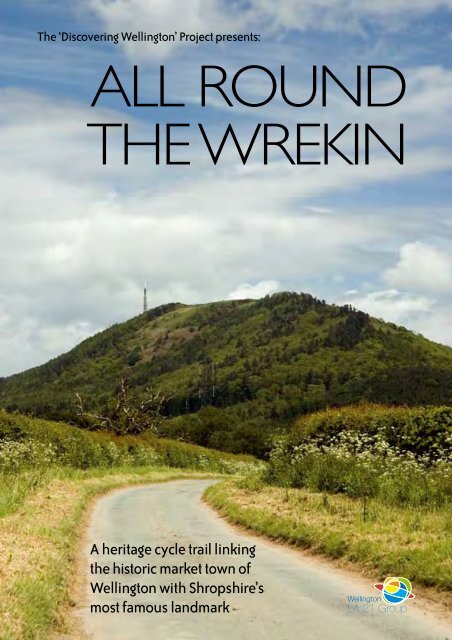
<strong>The</strong> ‘Discovering <strong>Wellington</strong>’ Project presents:<br />
ALL ROUND<br />
THE WREKIN<br />
A heritage cycle trail linking<br />
the historic market town of<br />
<strong>Wellington</strong> with Shropshire’s<br />
most famous landmark<br />
<strong>Wellington</strong><br />
LA <strong>21</strong> <strong>Group</strong>
‘ALL ROUND<br />
THE WREKIN’<br />
<strong>The</strong> <strong>Wrekin</strong> is one of the Midlands most famous<br />
natural landmarks and a source of pride and<br />
inspiration to generations of Salopians. <strong>The</strong> hill is<br />
a scheduled ancient monument and part of an Area<br />
of Outstanding Natural Beauty with at least 3000<br />
years of human history behind it, whose creation<br />
pre-dates life on Earth itself. Over the course<br />
of many centuries, <strong>The</strong> <strong>Wrekin</strong> has withstood<br />
feuding Celtic tribes, pillaging Roman invaders,<br />
tyrannical medieval monarchs and the ravages of<br />
the Industrial Revolution. More importantly, it has<br />
survived to tell the tale, so come with us now and<br />
discover some of the incredible stories from all<br />
round <strong>The</strong> <strong>Wrekin</strong>...<br />
Out and About<br />
<strong>The</strong> <strong>Wrekin</strong> from Holyhead Road, <strong>Wellington</strong><br />
<strong>The</strong> <strong>All</strong> <strong>Round</strong> <strong>The</strong> <strong>Wrekin</strong> trail is an 11 mile circular<br />
cycle route using quiet country lanes and existing<br />
parts of the National Cycle Network. <strong>The</strong> trail<br />
begins and ends in <strong>Wellington</strong>, <strong>The</strong> <strong>Wrekin</strong>’s very<br />
own market town. <strong>Wellington</strong>’s history is deeply<br />
intertwined with that of the hill and, during the<br />
middle ages, it was even known as <strong>Wellington</strong>-<br />
Under-<strong>The</strong> <strong>Wrekin</strong>. <strong>The</strong> town is an excellent place<br />
to start your adventure, so just follow the map in the<br />
centre of the booklet and remember to follow the<br />
Highway Code at all times.<br />
In <strong>The</strong> Beginning<br />
<strong>The</strong> <strong>Wrekin</strong> from the Ercall<br />
<strong>The</strong> <strong>Wrekin</strong> was created over 566 million years ago<br />
during a period of mountain building called the<br />
Caledonian Orogeny and its rocks are older than<br />
those of both <strong>The</strong> Alps and <strong>The</strong> Andes. Contrary<br />
to popular belief, <strong>The</strong> <strong>Wrekin</strong> is not a volcano but<br />
is made up from layers of solidified magma and<br />
lava that are over a mile thick. When the hill was<br />
formed, Shropshire lay roughly where the Falkland<br />
Islands are today and some of its sandstones<br />
(known as <strong>Wrekin</strong> Quartzite) would originally have<br />
formed part of a beach. Although the tide has long<br />
since gone out, a rippling effect can still be seen in<br />
the rock today, just past the first bend on the main<br />
track up the hill.
Wrockwardine<br />
Wrockwardine, ‘the enclosure by <strong>The</strong> <strong>Wrekin</strong>’, is an<br />
ancient settlement that has enjoyed considerable<br />
status during its long existence. It was a Royal<br />
Manor before the Norman Conquest and a<br />
Hundred meeting place, which was a unit of local<br />
government introduced in the 10th Century. As<br />
such, Wrockwardine held distinct rights of common<br />
over all of the Weald Moors, on <strong>The</strong> <strong>Wrekin</strong> and<br />
in the woods to the east of <strong>Wellington</strong>, in the area<br />
known nowadays as Wrockwardine Wood.<br />
St Peter’s Church<br />
Cycling from <strong>Wellington</strong> along Wrockwardine Road,<br />
your first view of the village is likely to be the spire<br />
of St Peter’s. <strong>The</strong> Church may have been founded in<br />
Saxon times but the earliest surviving parts of the<br />
existing foundation are of Norman origin and date<br />
from the mid 12th Century. At that time, St Peter’s<br />
was rebuilt to its current ‘cruciform’ plan with a new<br />
nave, central tower and north and south transepts.<br />
Earlier, after the Norman Conquest, the Lord of<br />
<strong>The</strong> Manor, Roger de Montgomery, had granted<br />
the Church ‘at Worgordina’ (Wrockwardine) to<br />
Shrewsbury Abbey (which was dedicated to St<br />
Peter) as a gift.<br />
St Peter’s Church<br />
Cludde Almshouses<br />
<strong>The</strong> Almshouses, which stand opposite the<br />
junction of Wrockwardine Road and <strong>The</strong> Avenue,<br />
were erected in 1841, as a memorial to the local<br />
landowner Edward Cludde of Orleton Hall. <strong>The</strong><br />
building was paid for by subscription from his<br />
‘tenants and neighbours’ and ‘endowed for the<br />
maintenance of two poor women in their declining<br />
years’. <strong>The</strong> stone tablet above the doorway pays<br />
testament to Cludde’s good character in glowing<br />
terms, describing him as ’visiting the fatherless and<br />
the widows in their affliction and keeping himself<br />
unspotted from the world’.<br />
Burcotgate Tollhouse<br />
<strong>The</strong> Cludde Almshouses<br />
A Turnpike Trust was set up to maintain the section<br />
of Watling Street through Wrockwardine parish<br />
in 1726, when a gate was probably constructed<br />
near Burcot to collect tolls from people using the<br />
road. <strong>The</strong> tollhouse at Burcotgate, which is also<br />
known as the Umbrella House, was rebuilt in 1835<br />
during Thomas Telford’s project to bypass Overley<br />
Hill. <strong>The</strong> system of collecting tolls continued until<br />
the mid 1860s, when Watling Street was officially<br />
‘disturnpiked’.
<strong>Wellington</strong><br />
<strong>Wellington</strong> is a market town with a long and<br />
illustrious past dating back to Anglo-Saxon times,<br />
when a pre-Christian religious temple may have<br />
stood near to the site of what is now <strong>All</strong> Saints<br />
parish church. <strong>The</strong> town received its first Royal<br />
Charter in 1244, was garrisoned during the Civil War<br />
and became a prosperous centre for Industry and<br />
agriculture during the Victorian era.<br />
1244 and <strong>All</strong> That<br />
At the beginning of the 13th Century, the population<br />
of <strong>Wellington</strong> was probably little more than a<br />
hundred people living in a few houses around <strong>The</strong><br />
Green next to <strong>All</strong> Saints church. During 1244, in<br />
what may have been an attempt to promote urban<br />
and commercial development, Giles de Erdington<br />
New Street<br />
(the Lord of the Manor) successfully applied to the<br />
Crown for a Royal Charter that enabled him to hold<br />
a weekly Thursday market and an annual June fair.<br />
In <strong>Wellington</strong> itself, the most notable impact of the<br />
Charter was the physical expansion of the town,<br />
with Church Street being extended towards the<br />
current Market Square, which then stretched to Tan<br />
Bank. <strong>The</strong> three small streets now leading off <strong>The</strong><br />
Square (Duke Street, Bell Street and Crown Street)<br />
all evolved over the course of several centuries, as<br />
market stalls in the area became established and<br />
eventually turned into permanent buildings. New<br />
Street, which is still <strong>Wellington</strong>’s main shopping<br />
thoroughfare, was also laid out after the charter,<br />
when merchants houses were built along the course<br />
of the road on long, narrow strips of land known as<br />
burgage tenements.<br />
<strong>The</strong> Medieval Town<br />
Of all the towns in east Shropshire, modern day<br />
<strong>Wellington</strong> is unique in retaining its medieval street<br />
layout, with all the roads in the centre of town<br />
emanating in a grid from the Market Square and<br />
the Church. Walker Street, Market Street (which<br />
was then known as Butcher Lane) and Newhall<br />
Street (later Foundry Lane – now buried under the<br />
Leisure Centre’s car park!) were all established by<br />
the beginning of the 14th Century. <strong>Wellington</strong>’s<br />
street names also help to reveal the identities of<br />
some of the trades and industries that went on in<br />
the town during medieval times. Ten Tree Croft (a<br />
footpath leading from Church Street to Bridge Road)<br />
is a derivation of the word Tentercroft, the place<br />
where dyers hung out their woollen cloth to dry<br />
on tenterhooks. <strong>The</strong> name Walker Street is also an<br />
indication of the importance of cloth manufacturing<br />
in the town during the medieval period. Here, the<br />
process of fulling took place, where workers quite<br />
literally walked on the cloth in order to make it<br />
heavier and more compact. Leather making was<br />
another important trade in <strong>Wellington</strong> and Tan<br />
Bank takes its name from the tannery that once<br />
existed there.<br />
Church Street
Little Wenlock<br />
Little Wenlock was originally an outlying estate of<br />
the Priory at Much Wenlock and the name itself may<br />
derive from the Celtic word ‘gwyn-loch’, meaning<br />
‘monastery’ or ‘white place’. During the 18th and<br />
19th Centuries, the prosperity of the area was tied<br />
up with the fortunes of local industry. Settlements<br />
sprang up at Huntington Heath, Smalleyhill, Little<br />
Worth and New Works, developing from cottages<br />
built by miners and other workers who came to the<br />
coalfield looking for employment. By 1841, over a<br />
thousand people lived in the parish but after the<br />
industrial downturn of the late 19th Century, the<br />
number had practically halved.<br />
Coals To Wenlock<br />
Coal mining played a vital role in the history of<br />
Little Wenlock from at least the 14th Century. By the<br />
1600s, the coalfield centred around the village itself,<br />
Coalmoor and New Works, which acquired its name<br />
from the large number of collieries centred around<br />
the area by the beginning of the 18th Century. Many<br />
In Limekiln Wood<br />
of these mines lay on the estate of the Forester<br />
family, who played an important part in the rapid<br />
industrialisation of east Shropshire. In 1777, George<br />
Forester leased his coalmines at New Works to<br />
Abraham Darby III and his Coalbrookdale<br />
Company later extracted over 10000 tons of coal<br />
from the area, for use in the iron making process.<br />
<strong>The</strong> opening of Lawley Furnaces in 1822, bolstered<br />
production again but by the end of the 19th Century<br />
commercial mining had all but ceased in the Little<br />
Wenlock coalfield. <strong>The</strong> final colliery at New Works<br />
closed in 1901.<br />
Making Tracks<br />
<strong>The</strong> <strong>Wrekin</strong> from Spout Lane<br />
So great was the demand placed on the collieries<br />
in the Little Wenlock coalfield, that some of the first<br />
primitive railways were constructed there, to carry<br />
coal and lime from the area in horse-drawn trucks.<br />
In 1749, William Forester laid a two-mile tramway<br />
across his estate from Coalmoor to Coalbrookdale<br />
to supply local foundries with raw materials and<br />
export coal to the numerous wharves on the River<br />
Severn. To be nearer to the source of materials<br />
required for iron making, Abraham Darby II opened<br />
a new foundry at Horsehay in 1755 and, after this<br />
date, new tramways were built to link mines with<br />
foundries rather than with the River Severn. A<br />
wagonway was constructed between Coalmoor<br />
and the Horsehay Ironworks for the Coalbrookdale<br />
Company in 1776 and another line from the<br />
Forester’s limekilns at <strong>The</strong> Hatch was in existence<br />
by 1833. <strong>The</strong> path of one of these tramways can<br />
still be traced today, passing through the middle<br />
of Black Hayes and Limekiln Wood in <strong>The</strong> <strong>Wrekin</strong><br />
Forest itself.
<strong>The</strong> Royal Forest<br />
of Mount Gilbert<br />
A thousand years ago, the woodland around <strong>The</strong><br />
<strong>Wrekin</strong> formed part of a Royal Forest providing<br />
food, timber and hunting for the Crown. Before<br />
the Norman Conquest, the forest covered an area<br />
between the Orleton Estate and New Works, but by the<br />
reign of Henry II, it extended over 120 square miles,<br />
stretching from Hadnall to Sheriffhales in the east and<br />
southwards towards Buildwas and Madeley. <strong>The</strong> forest<br />
also included <strong>Wellington</strong> Hay, an enclosure for deer,<br />
which ran from Watling Street to the Ercall Hill.<br />
Norman Forest Law<br />
<strong>The</strong> forests created by the Normans were very<br />
different from the kind we might expect to see today<br />
and were essentially independent power bases<br />
where the King could wield his authority and make<br />
money. Many contained large areas with no woodland<br />
cover at all and included whole towns and villages.<br />
A highly draconian set of rules and punishments<br />
were established to deal with any offences against<br />
the ‘venison and vert’ (Venison being Wild Boar and<br />
Deer and the vert their habitat; the forest itself) and<br />
severe restrictions were placed on anything that<br />
might interfere with the wild game, from the felling of<br />
trees to gathering firewood and acorns. In the very<br />
worst cases, anyone found guilty of illegally hunting<br />
venison ran the risk of being executed. In order to<br />
ensure that people obeyed the rules, systems of<br />
courts existed to enforce the law in each forest and<br />
were presided over by powerful royal officials known<br />
as Verderers or Foresters. <strong>The</strong> Forester family were<br />
the hereditary wardens of Mount Gilbert and it was<br />
their duty to ‘walk the forest early and late’, watch<br />
the venison and vert, and to present trespassers to<br />
the local court. <strong>The</strong> forest area eventually became so<br />
large that it had to be separated into three ‘regards’,<br />
known as the Bailiwicks of Haughmond, Wombridge<br />
and Mount Gilbert itself.<br />
Why Mount Gilbert?<br />
In the forest near Little Hill<br />
After the Norman Conquest, the authorities<br />
attempted to rename <strong>The</strong> <strong>Wrekin</strong> in honour of<br />
a local hermit. In 1267, we find evidence of his<br />
existence when Henry III granted to ‘Nicolas de<br />
Denton, heremite of Mount Gilbert’, six quarters<br />
of corn ‘to give the hermit greater leisure for holy<br />
exercises, and to support him during his life, so<br />
long as he should be a hermit on the aforesaid<br />
mountain’. However, de Denton was almost<br />
certainly not the last hermit living on the hill, as<br />
Thomas Gamel of Shrewsbury left a legacy of 18d<br />
for ‘the hermit on the Wroeken’ in 1355.
Life In<br />
<strong>The</strong> Royal Forest<br />
After the imposition of Norman Forest Law, it would<br />
be easy to imagine <strong>The</strong> <strong>Wrekin</strong> as a no-go area for<br />
all but a privileged few. In reality, it was anything<br />
but and many people still depended on the forest<br />
for their livelihoods. Even in <strong>Wellington</strong> Hay, local<br />
people could graze their cattle for most of the year,<br />
in payment of a small fee known as an ‘agistment’.<br />
<strong>The</strong> forest floor also provided an ideal habitat<br />
for the rearing of pigs, an important part of the<br />
medieval economy. In 1255, the ’men of <strong>Wellington</strong>’<br />
had to pay 2 pence to graze a ‘yearling swine’, and 1<br />
penny for a six-month-old pig.<br />
Decline<br />
<strong>The</strong> Crown’s constant need for money ensured<br />
that many illegal practices, such as Pourprestures<br />
(erecting buildings) and Assarting (clearing<br />
the forest for farming) were legally licensed.<br />
Unfortunately, this appears to have led some<br />
officials to abuse their powers. In 1255, a Jury of<br />
the local Bradford Hundred Court<br />
was called to examine why two<br />
Under Foresters were charging<br />
‘Cheminage’ (an illegal toll) on teams<br />
of pack-horses passing through the<br />
Bailiwick of Haughmond. In nearby<br />
Haughton, the local officials also<br />
demanded dues of poultry, wheat<br />
and oats without warrant. By 1<strong>21</strong>7,<br />
Forest Law became so unpopular in<br />
England that a Charter was drawn<br />
up to remove many of the recent<br />
additions to the Royal forests.<br />
During the reign of Henry II, one<br />
third of Shropshire may have been<br />
under forest jurisdiction but, by the<br />
13th Century, this figure fell sharply.<br />
At the forest assizes of 1250, many local settlements,<br />
including <strong>Wellington</strong>, Hadley and Dawley, were<br />
exempted from the ‘regard’ of <strong>The</strong> <strong>Wrekin</strong> Forest.<br />
<strong>The</strong>se exemptions were often preceded by an<br />
official survey, known as a ‘perambulation’, where<br />
several officials walked the forest to determine<br />
its extent. After the ‘Great Perambulation’ of June<br />
1300, the Norman Forest practically ceased to exist<br />
and only <strong>Wellington</strong> Hay remained as a ‘Royal<br />
demesne’, surviving until the 15th Century.<br />
<strong>The</strong> Forest Today<br />
Although there is little evidence of the extent of<br />
the Norman Forest of Mount Gilbert today, many of<br />
the names of surrounding settlements give a clue<br />
to their original location as forest villages. Place<br />
names ending in ‘lee’ or ‘ley’ (such as Malinslee,<br />
Ketley and Madeley) would almost certainly<br />
have begun as clearings within the forest area. In<br />
<strong>Wellington</strong>, the names of both Haygate Road and<br />
<strong>The</strong> Wickets Pub on Holyhead Road may indicate<br />
the positions of former entrance gates into the deer<br />
enclosure on <strong>Wellington</strong> Hay.<br />
In the forest near Hazlehurst
Around <strong>The</strong> Ercall<br />
As you cycle north from Little Wenlock and back<br />
towards <strong>Wellington</strong>, the other hills of <strong>The</strong> <strong>Wrekin</strong><br />
range begin to come into view. Maddock’s Hill,<br />
Lawrence’s Hill and <strong>The</strong> Ercall have all suffered the<br />
ravages of extensive quarrying but remain as areas<br />
of great geological and scientific importance. In<br />
Ercall Lane itself, the woodland to your right is home<br />
to many rare plants and animals and has a history<br />
stretching back beyond the Norman Conquest.<br />
<strong>The</strong> Ercall Quarries<br />
<strong>The</strong> Ercall Quarries are an internationally significant<br />
geological site, renowned for their exposures of<br />
<strong>Wrekin</strong> Quartzite and Precambrian Uriconian<br />
Volcanics. In the quarry, it is easy to see a change in<br />
the rock from the pink tinge of granite to a pale grey<br />
colour. This ‘unconformity’ marks the transition<br />
from the Precambrian to Cambrian period when life<br />
on earth became more numerous and varied. If you<br />
look carefully, it is also possible to observe ripples<br />
in the sandstone, formed on a beach around 540<br />
million years ago.<br />
<strong>The</strong> Ercall Quarries<br />
Short Wood, Limekiln Wood<br />
and Black Hayes<br />
Short Wood, Limekiln Wood and Black Hayes all<br />
contain areas of semi-natural, ancient woodland<br />
that formerly belonged to the Royal Forest of Mount<br />
Gilbert and <strong>Wellington</strong> Hay. Although the area has<br />
suffered the ravages of industrial activity over the<br />
course of many centuries, the woods still contain a<br />
rich botanic heritage. <strong>The</strong> Limekiln Wood contains<br />
over 150 different woodland plants including, Lily<br />
of the Valley, Dog’s Mercury and Bird’s Nest Orchid.<br />
<strong>The</strong> abandoned mine workings in the area have<br />
In Ercall Wood<br />
also been used as roosting sites by Daubentons,<br />
Pipistrelle and Long–Eared Bats. <strong>The</strong> northern part<br />
of the wood was given to the people of <strong>Wellington</strong><br />
by the owners of the Dothill Estate during the 19th<br />
Century and is still in public ownership today.
Around <strong>The</strong> <strong>Wrekin</strong><br />
Here are some of the things to look out for<br />
as you cycle around the hill.<br />
<strong>The</strong> Forest Glen<br />
Until 1993, the car park at the top of Ercall Lane was occupied by the<br />
Forest Glen Pavilion. Erected in 1889, the building became a Mecca<br />
for locals and tourists alike, serving morning and afternoon tea in<br />
the summer and holding dinner dances during the evenings. In the<br />
Victorian era, visitors were transported here by horse and carriage from<br />
<strong>The</strong> Station Hotel in <strong>Wellington</strong>, which like the Pavilion was owned by<br />
the Pointon family. After its closure, the building was saved and re-<br />
assembled at Blists Hill Museum in Coalport and the site itself is now<br />
owned by the Shropshire WildlifeTrust.<br />
<strong>The</strong> <strong>Wrekin</strong> Course and the Rifle Range<br />
<strong>The</strong> <strong>Wrekin</strong> Course is the lane that runs from just passed Aston to <strong>The</strong><br />
Ercall Pools. During the 18th Century, members of the local gentry ran<br />
horse races here, which is probably how the road got its name. Half way<br />
along the course is the site of the old rifle range, formerly used by the<br />
King’s Shropshire Light Infantry among others. Although there are still<br />
signs in parts of the forest warning passers-by of the potential hazards<br />
of flying bullets, a rifle has not been fired here for many years...officially!<br />
Aston<br />
Aston was recorded as one of <strong>Wellington</strong>’s five Berewicks at the time<br />
of the Domesday Survey in 1086. A Berewick was an outlying holding<br />
belonging to the Manor and the term is derived from the old English<br />
word for ‘corn farm’. During the middle of the 12th Century, the owner,<br />
Empress Maud, granted the settlement to Shrewsbury Abbey but the<br />
monks could only take possession after they had received a charter<br />
from Richard I in 1190.<br />
Little Hill And Neves Castle<br />
At the ripe old age of approximately 677 million years, Little Hill is the oldest<br />
of part <strong>The</strong> <strong>Wrekin</strong> range and contains rocks that, in geological terms, pre-date<br />
life on Earth itself. In the 19th Century, it was known as Primrose Hill, a name<br />
that fell out of use when the flower died out here.<br />
Neves Castle takes its name from the small Motte and Bailey mound situated<br />
beneath Little Hill on the opposite side of Spout Lane. <strong>The</strong> site is of unknown<br />
origin and may not even have been a castle at all.<br />
Walcot<br />
B5061<br />
Uppington<br />
Cross Green<br />
B4394<br />
<strong>The</strong> Rifle Range<br />
Leaton<br />
A5<br />
Rushton<br />
Wrockwardine<br />
Aston<br />
Neves Castle<br />
Upper<br />
Longwood<br />
SHORT CUT<br />
Burcotgate<br />
<strong>The</strong> <strong>Wrekin</strong><br />
Little<br />
Hill<br />
<strong>Wrekin</strong> Course<br />
Needle’s Eye<br />
Little Hill<br />
B5061<br />
Shaw<br />
Sha<br />
A<br />
Wrockwardine Ro<br />
Hell Gate<br />
Rifle Range<br />
Heaven Gate<br />
Hill For<br />
Raven’s B<br />
Lit
<strong>Wellington</strong> Leegomery<br />
dmaston<br />
t<br />
birch<br />
wbirch Road<br />
ad<br />
Holyhead Road<br />
owl<br />
Ercall Lane<br />
<strong>The</strong> Ercall<br />
Lawrence’s Hill<br />
Forest Glen<br />
Limekiln<br />
Wood<br />
<strong>The</strong> Dairy Pit<br />
Maddock’s Hill<br />
tle Wenlock<br />
Spring H ill<br />
Willowmoor<br />
Queensway<br />
Huntington<br />
M54<br />
<strong>The</strong> Dairy Pit<br />
A4169<br />
A442<br />
Whitchurch Drive<br />
A5223<br />
Watling Street Bennets Bank<br />
Arleston<br />
Just off the right hand side of the road between Hazlehurst and<br />
Lawrence’s Hill are a group of artificial mounds surrounding a small<br />
<strong>The</strong> Beacon<br />
A beacon has stood near the summit of <strong>The</strong> <strong>Wrekin</strong> since at least Tudor<br />
times, when the antiquary John Leland declared that the hill ‘standeth<br />
as a Pharos, barren of wood’. In his celebration of the defeat of the<br />
Spanish Armada, the 19th Century poet Lord Macaulay described as<br />
‘streamed on the wind, the <strong>Wrekin</strong>’s crest of light’ as it warned of the<br />
approaching enemy fleet. <strong>The</strong> <strong>Wrekin</strong> reprised this role during World<br />
War II, when an aircraft-warning beacon was erected on the hill.<br />
Willowmoor<br />
Although little evidence remains today, Willowmoor is the site of<br />
several Bronze Age barrows. In 1835, a large array of weaponry was<br />
discovered in one of the mounds, supposedly by a farm labourer<br />
digging a drain. Among the hoard were over 150 fragments of<br />
spearheads, an axe and some swords. Some of these artefacts can<br />
now be seen at the local history museum in Shrewsbury.<br />
<strong>The</strong> Hatch<br />
pool known as the Dairy or Davy Pit. If you are feeling inquisitive and<br />
decide to take a closer look, beware!<br />
According to local legend, the pool is home to a mermaid who likes<br />
nothing more than luring young men to a watery grave. <strong>The</strong> Dairypit<br />
is also reputed to be haunted by Rutter’s Ghost, the spirit of an 18th<br />
Century ‘Cricker’ or Packhorse Driver.<br />
Junction 6<br />
Dawley Road<br />
Hadley<br />
Ketley<br />
Lawley Drive<br />
Lawley<br />
Horsehay<br />
<strong>The</strong> area to the north of Willowmoor Lane played a significant role<br />
in the industrial development of east Shropshire from the 18th<br />
Century onwards. <strong>The</strong> Forester family opened several quarries to<br />
exploit rich deposits of limestone, an important raw material in iron<br />
making. In the early 19th Century, a tramway linked the limekilns<br />
with the Coalbrookdale Company’s works at Horsehay and lime was<br />
also quarried at the Oldfield Works (north of the road between Little<br />
Wenlock and <strong>The</strong> Hatch Bank) and Cross Field, in Huntington Lane.<br />
<strong>The</strong> Hatch was one of the last operational lime workings in the area<br />
and closed in 1918.<br />
<strong>The</strong> Ercall Pools
<strong>The</strong> <strong>Wrekin</strong><br />
Hillfort<br />
People appear to have lived on <strong>The</strong> <strong>Wrekin</strong> since<br />
at least 1000 BC, when roundhouses were first<br />
constructed on the hill. <strong>The</strong> defensive walls of<br />
the hillfort were probably begun later, around<br />
450BC, after these houses had been burnt down,<br />
possibly in act of tribal warfare. <strong>The</strong> outer and<br />
inner entrances of the hillfort, known as ‘Hell Gate’<br />
and ‘Heaven Gate’, are still visible today on the<br />
northeast side of the hilltop and form part of what<br />
is a scheduled ancient monument.<br />
<strong>The</strong> Cornovii<br />
Until the invading Roman army reached the<br />
area, <strong>The</strong> <strong>Wrekin</strong> was probably the principal<br />
hillfort of the Celtic Cornovii tribe. <strong>The</strong>ir kingdom<br />
stretched southwards from Meols, on the Wirral, to<br />
Titterstone Clee in south Shropshire, with a western<br />
border that was roughly equivalent to the current<br />
boundary between England and Wales. While <strong>The</strong><br />
<strong>Wrekin</strong> may have been the tribe’s principal hillfort,<br />
it is likely that the sparse population of the Cornovii<br />
kingdom lived over a far wider area, in low-lying<br />
On the hill top, looking towards the Severn Valley<br />
farmsteads across the Severn Valley. Due to its<br />
height, <strong>The</strong> <strong>Wrekin</strong> may only have been occupied<br />
seasonally or at times of uncertainty for the tribe.<br />
Apart from providing security for the Cornovii, the<br />
hillfort may have served as an outward indication to<br />
others of tribal status, which would help to explain<br />
the large number of hillforts throughout their<br />
kingdom. It is likely that the tribe derived much of<br />
its wealth from agriculture and these hillforts may<br />
also have served as cattle stockades. Some forts<br />
probably had a religious function, demonstrated by<br />
the presence of shrines at some sites. A holy well,<br />
dedicated to St Hawthorn, was recorded on <strong>The</strong><br />
<strong>Wrekin</strong> up until the 19th Century.<br />
How Did <strong>The</strong> Cornovii Live<br />
It has been argued that the Cornovii were neither<br />
as wealthy or culturally advanced as other Iron<br />
Age tribes in Britain. <strong>The</strong>ir kingdom was largely<br />
Hell Gate, looking towards the Ercall<br />
landlocked and a rival tribe blocked trade routes<br />
to the south. While little evidence has been<br />
uncovered of the Cornovii possessing many<br />
material goods, there are many reasons to suppose<br />
that they were not as primitive as first thought.<br />
<strong>The</strong> presence of many lowland farms across the<br />
Cornovii kingdom suggests that the tribe had a<br />
well-developed agricultural economy and may<br />
have chosen to display their prosperity through the<br />
possession of livestock and land. <strong>The</strong> Cornovii also<br />
controlled three brine springs in south Cheshire,<br />
from which they could have derived considerable<br />
commercial benefits. <strong>The</strong> salt from these springs<br />
would have been used in processing leather and<br />
cloth and the salting of meat.
<strong>The</strong> Roman<br />
Invasion<br />
Around the year 43AD, four legions of the Roman<br />
army invaded Britain with a view to taking over the<br />
island. Moving northwestwards along the course<br />
of Watling Street, the Legio XIV Gemina appears<br />
to have stormed the hillfort on <strong>The</strong> <strong>Wrekin</strong> in<br />
the spring of 47AD. A large ‘vexillation’ fortress<br />
(consisting of Roman legionnaires and non-Roman<br />
infantry and cavalry) was erected by the River<br />
Severn to the southeast of Eaton Constantine and<br />
may have housed some of the troops assigned to<br />
destroy the hillfort.<br />
Romanisation<br />
When the hillfort fell to the conquering Roman<br />
Army, it is unclear how the Cornovii tribe reacted.<br />
<strong>The</strong> attack itself may have been a symbolic<br />
demonstration of Roman military power and it<br />
is possible that the tribe could have viewed the<br />
invasion as a trading opportunity and a source of<br />
greater security. It was not always the policy of the<br />
Romans to alienate the local population, but rather<br />
to incorporate it into traditional roman ways of<br />
trading, and many goods and services would have<br />
been acquired locally. However, the<br />
Heaven Gate and the transmitter<br />
On the hill top, looking towards Limekiln Wood<br />
economic and cultural differences between the<br />
Cornovii and the Romans were initially very large.<br />
<strong>The</strong> Cornovii tradition of mutually sharing wealth<br />
and resources would have been totally at odds with<br />
Roman consumer society. Those dealing directly<br />
with the invaders would also have been expected<br />
to use money, which the Cornovii do not generally<br />
appear to have done beforehand. <strong>The</strong> existing<br />
Cornovii Industries associated with salt production<br />
would have also been taken over by the Romans,<br />
who erected forts at Middlewich, Nantwich and<br />
Northwich to protect their newly acquired interests.<br />
Viroconium-Cornoviorum<br />
<strong>The</strong> former population of the hillfort on <strong>The</strong> <strong>Wrekin</strong><br />
probably migrated to Wroxeter, later known as<br />
Viroconium-Cornoviorum (Viroconium of the<br />
Cornovii) a name that may have been transferred<br />
from the former settlement on the hill. <strong>The</strong> town<br />
itself was founded around 90AD, when the Roman<br />
Twentieth Legion, whose fortress had been situated<br />
on the site, moved to a new military base at Deva<br />
(Chester). This development marked the transition<br />
from military control of the area back to the Cornovii,<br />
who then administered their affairs once again.<br />
Documentary evidence suggests that the site was<br />
still called ‘Utriconian Cornoviorum’ in the 7th<br />
Century, indicating the town’s continued status<br />
as a tribal capital long after the Roman invasion<br />
had ended.
Myths and Legends<br />
of <strong>The</strong> <strong>Wrekin</strong> Hill<br />
We now know that <strong>The</strong> <strong>Wrekin</strong> was almost certainly<br />
fashioned by the hand of a giant but opinion still<br />
varies as to how exactly this incredible event came<br />
to pass. <strong>The</strong> following story is, we believe, the most<br />
plausible explanation…<br />
Here Be Giants!<br />
Looking towards Raven’s Bowl<br />
Ercol and Madog were two troublesome giants<br />
who had been exiled from their own community.<br />
One day, while passing through the area, they both<br />
decided it would be an ideal place to set up home.<br />
Grabbing their spades, the two brothers dug a<br />
long trench and began to pile up the earth into a<br />
massive hill. When they got to the top, which being<br />
Giants did not take them very long, Ercol and Madog<br />
noticed the trench had filled up with water. Yes,<br />
apart from building <strong>The</strong> <strong>Wrekin</strong>, they had created<br />
the River Severn as well!<br />
Rather than content themselves with this feat,<br />
sibling rivalry soon set in and the brothers began to<br />
squabble about who should get to live on the hill.<br />
After all, there was not room enough for both<br />
of them! Ercol, who found arguing very tiresome,<br />
took his spade and attempted hit Madog as hard as<br />
he could but, before the giant could do anything,<br />
a passing Raven (who, like all civilised creatures,<br />
deplored the use of violence) flew up and pecked<br />
his eye! <strong>The</strong> results of what happened next can still<br />
be seen today…<br />
<strong>The</strong> Needles Eye and<br />
the Raven’s Bowl<br />
With a great crash, Madog’s spade fell to earth and<br />
gouged out ‘<strong>The</strong> Needle’s Eye’ in the rock below. So<br />
upset was the giant by the bird’s unexpected attack<br />
that a huge tear rolled down from his injured eye<br />
and formed a small pool nearby. ‘<strong>The</strong> Raven’s Bowl’<br />
or ‘Cuckoo’s Cup, as it is known, is reputed never<br />
to have dried up since! Yet, even then, Ercol and<br />
Madog continued to struggle grimly for supremacy<br />
of <strong>The</strong> <strong>Wrekin</strong>. In fact, they fought so hard that<br />
the grass around the Bladder Stone, near the hill’s<br />
summit, refuses to grow back even to this day!<br />
Eventually, Madog got the better of his wounded<br />
brother and began to pile earth on top of him, until<br />
he had completely buried poor Ercol! And there<br />
he remains, imprisoned beneath the Ercall Hill,<br />
occasionally crying out for help to unsuspecting<br />
passers-by, but only at the dead of night…<br />
<strong>The</strong> Needle’s Eye
Are You<br />
Feeling Lucky?<br />
Fear not, for Ercol and Madog’s misfortune need not<br />
be yours. A trip up <strong>The</strong> <strong>Wrekin</strong> could potentially<br />
bring you a great deal of luck! For centuries,<br />
folklore and tradition have played a large part in<br />
many a trip up the hill...<br />
Through <strong>The</strong> Needles Eye<br />
When you reach the Raven’s Bowl (a small<br />
depression in a rocky outcrop near the summit)<br />
drop a pin in it, and good fortune will follow you.<br />
If you are already lucky enough to be visiting the<br />
hill with a partner, you could take a trip through the<br />
Needle’s Eye – but only from west to east, or it won’t<br />
work. Make sure your companion is waiting on the<br />
other side of the cleft in the rock and, when you<br />
<strong>The</strong> Cuckoo’s Cup or Raven’s Bowl<br />
have climbed through (without stumbling) demand<br />
a kiss from them. A lifetime of wedded bliss is sure<br />
to follow, apparently. However, Ladies do beware!<br />
If you look back whilst passing through the Needle’s<br />
Eye, you will never be married at all!<br />
During the 19th Century, there also existed a custom<br />
whereby people visited the hill on Easter Day to<br />
‘See the Sun dance three times when he rose’.<br />
Quite what fortune this was supposed to bring<br />
remains a mystery, along with the details of the<br />
celestial body’s gyratory movements!<br />
<strong>The</strong> <strong>Wrekin</strong> Wakes<br />
On the hill top<br />
Until the 19th Century, <strong>The</strong> <strong>Wrekin</strong> played host to<br />
a festival of drunken debauchery and gratuitous<br />
violence every four Sundays in May. <strong>The</strong> <strong>Wrekin</strong><br />
Wakes began as a vigil of prayer on the eve of<br />
a religious festival but eventually turned into<br />
something quite different. According to the<br />
reminiscences of one local person, writing in<br />
1873, <strong>The</strong> <strong>Wrekin</strong> was ‘covered by a multitude of<br />
pleasure seekers’ who enjoyed ‘all the etceteras of<br />
an English fair’. <strong>The</strong> grand finale of the event was<br />
a pitched battle for possession of the hill between<br />
local Colliers and Countrymen. However, this form<br />
of popular entertainment did not sit comfortably<br />
with Victorian ideas on morally productive leisure<br />
pastimes and the Cludde family of Orleton Hall<br />
eventually suppressed the wakes.
<strong>The</strong> Past, Present and Future…<br />
After you’ve cycled round <strong>The</strong> <strong>Wrekin</strong> we are sure you<br />
will agree that it is a place worth protecting for future<br />
generations to enjoy - You can be part of helping<br />
to ensure that this happens.<br />
How You Can Help<br />
<strong>Wellington</strong> <strong>Local</strong> <strong>Agenda</strong> <strong>21</strong> <strong>Group</strong> is a voluntary<br />
organisation that aims to encourage local people<br />
to get involved in issues which impact on all of<br />
our everyday lives. Decisions made on our own<br />
doorsteps can make a real difference and the <strong>Local</strong><br />
<strong>Agenda</strong> <strong>21</strong> process exists to help individuals and<br />
groups work together to find solutions to a range of<br />
problems affecting the local environment, from litter<br />
picking to developing sustainable transport projects.<br />
<strong>The</strong> group maintains a long term commitment to<br />
helping support and protect the natural and historic<br />
heritage in and around <strong>Wellington</strong> and this includes<br />
<strong>The</strong> <strong>Wrekin</strong>. If you would like to learn more about<br />
our work and how you can get involved, visit us at:<br />
www.wellingtonla<strong>21</strong>.org.uk<br />
Acknowledgments<br />
Thanks go to: George and Naomi Evans,<br />
<strong>All</strong>an Frost, <strong>Wellington</strong> Civic Society, Borough of<br />
Telford, Shropshire County Council, New College-<br />
<strong>Wellington</strong>, <strong>The</strong> National Trust, Shropshire Wildlife<br />
Trust, Sustrans, <strong>Wellington</strong> Town Partnership,<br />
<strong>Wellington</strong> News, Tim Wakefield, WWS<br />
Webservices and <strong>All</strong> Friends Around <strong>The</strong> <strong>Wrekin</strong>!<br />
Written by: Marc Petty for <strong>Wellington</strong><br />
<strong>Local</strong> <strong>Agenda</strong> <strong>21</strong> <strong>Group</strong>.<br />
Photography: George Evans, Marc Petty,<br />
Tim Wakefield and Mike Ashton<br />
Designed by: MA Creative • www.macreative.co.uk<br />
Printed by CLH Design & Print • (01952) 505032<br />
Published by: <strong>Wellington</strong> <strong>Local</strong> <strong>Agenda</strong> <strong>21</strong><br />
<strong>Group</strong>, 2 Arrow Road, Shawbirch, Shropshire.<br />
© <strong>Wellington</strong> <strong>Local</strong> <strong>Agenda</strong> <strong>21</strong> <strong>Group</strong> 2006.
A5<br />
A458<br />
A442<br />
<strong>Wellington</strong><br />
A458<br />
A4169<br />
Visiting <strong>The</strong> <strong>Wrekin</strong><br />
On Two Wheels...<br />
If you are cycling in the area for the first time,<br />
<strong>Wellington</strong> is an excellent place to begin your<br />
journey. <strong>The</strong> railway station is located in the centre<br />
of the town with regular services to and from the<br />
West Midlands and Central Wales. Most local trains<br />
have capacity for up to two bikes (no tandems or<br />
tricycles) although a reservation may be required<br />
on some services. For more information visit:<br />
www.centraltrains.co.uk or<br />
www.arrivatrainswales.co.uk.<br />
Secure cycle parking is available at various<br />
locations around the town centre, while help<br />
with spares and repairs can be found at Perry’s<br />
Cycles, 33 Tan Bank. To find out more about the<br />
town’s history, pick up a copy of our ‘Victorian<br />
<strong>Wellington</strong>’ walk booklet at the Tourist Information<br />
Centre in <strong>Wellington</strong> News, Crown Street.<br />
Supported by:<br />
to Oswestry<br />
& N. Wales<br />
A49<br />
A49<br />
to Ludlow<br />
& Hereford<br />
A49<br />
to Whitchurch<br />
A49<br />
SHREWSBURY<br />
A5<br />
A5<br />
Atcham<br />
Church Stretton<br />
A53<br />
Shawbury<br />
M54<br />
Much Wenlock<br />
7<br />
M54<br />
A458<br />
6<br />
A5223<br />
A518<br />
5<br />
<strong>The</strong><br />
<strong>Wrekin</strong> TELFORD<br />
Leighton<br />
Ironbridge<br />
Newport<br />
A442<br />
4<br />
A4169<br />
Broseley<br />
A442<br />
to Kidderminster<br />
A5<br />
M54<br />
BRIDGNORTH<br />
A458<br />
to Stafford<br />
A41<br />
Shifnal<br />
A518<br />
Out and About…<br />
to Wolverhampton<br />
A454<br />
To follow the ‘<strong>All</strong> <strong>Round</strong> <strong>The</strong> <strong>Wrekin</strong>’ cycle trail just<br />
consult the route map in the centre of this booklet.<br />
Some of the trail utilises existing sections of routes<br />
45 and 81 of the National Cycle Network and further<br />
details relating to the network can be found by<br />
visiting www.sustrans.org.uk. Take care at all times<br />
along the trail and do follow the highway code. Ride<br />
single file where the road is narrow, slow down for<br />
passing walkers, horse riders and other vehicles<br />
and watch out for gravel or greasy roads after rain.<br />
<strong>The</strong> trail contains several steep gradients and busy<br />
junctions so always ride positively and decisively.<br />
For more information about <strong>The</strong> <strong>Wrekin</strong> and other<br />
local heritage attractions visit<br />
www.wellingtonla<strong>21</strong>.org.uk<br />
3<br />
Albrighton<br />
to Birmingham<br />
(M6)<br />
A41<br />
to Stourbridge<br />
<strong>Wellington</strong><br />
LA <strong>21</strong> <strong>Group</strong>