From medieval Beatine maps and Genoese nautical charts to ...
From medieval Beatine maps and Genoese nautical charts to ...
From medieval Beatine maps and Genoese nautical charts to ...

Create successful ePaper yourself
Turn your PDF publications into a flip-book with our unique Google optimized e-Paper software.
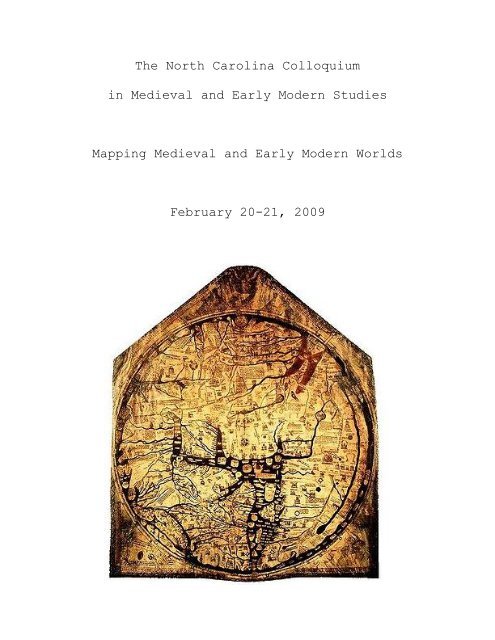
The North Carolina Colloquium<br />
in Medieval <strong>and</strong> Early Modern Studies<br />
Mapping Medieval <strong>and</strong> Early Modern Worlds<br />
February 20-21, 2009
The tenth annual North Carolina Colloquium in Medieval <strong>and</strong> Early Modern Studies, a<br />
graduate student conference jointly sponsored by Duke University <strong>and</strong> the University of North<br />
Carolina at Chapel Hill, will explore the ways that <strong>medieval</strong> <strong>and</strong> early modern individuals <strong>and</strong><br />
societies mapped, visualized, <strong>and</strong> conceived of their world in terms of its various spaces. The<br />
conference will focus on mapping as a symbolic <strong>and</strong> physical means through which individual,<br />
communal, religious, <strong>and</strong> cultural encounters were defined. Medieval <strong>and</strong> early modern mapping<br />
takes a variety of conceptual <strong>and</strong> physical forms: through literary genres such as allegory, travel<br />
narratives, <strong>and</strong> conduct guides, architectural plans <strong>and</strong> artistic representations, <strong>and</strong> developing<br />
scientific knowledge. The conference also seeks <strong>to</strong> address how contemporary discourses across<br />
disciplines have treated these spaces – conceptual, communal, religious, private, geographical –<br />
<strong>and</strong> their resulting illuminations or misconceptions.<br />
<strong>From</strong> <strong>medieval</strong> <strong>Beatine</strong> <strong>maps</strong> <strong>and</strong> <strong>Genoese</strong> <strong>nautical</strong> <strong>charts</strong> <strong>to</strong> Waldseemuller’s 1507<br />
world map, the physical activity of mapping participated in the translation <strong>and</strong> transcription of<br />
cultural, his<strong>to</strong>rical, political, religious, <strong>and</strong> imaginary encounters. In their articulation of these<br />
relationships, <strong>maps</strong> combined burgeoning scientific <strong>and</strong> geographical knowledge with a<br />
developing system of visual representation. Through literary texts, architecture, his<strong>to</strong>rical<br />
records, scientific development, <strong>and</strong> religious narratives, individuals <strong>and</strong> communities sought <strong>to</strong><br />
negotiate similar questions of space <strong>and</strong> representation. Investigating <strong>medieval</strong> <strong>and</strong> early modern<br />
practices of symbolic, social, <strong>and</strong> geographic mapping acknowledges the complexity <strong>and</strong><br />
difficulty of these cultural interactions, both real <strong>and</strong> imagined. Our conference is also interested<br />
in exploring the division often made between <strong>medieval</strong> <strong>and</strong> early modern conceptions of their<br />
spaces <strong>and</strong> world. Humanism, its corresponding secularism, <strong>and</strong> Protestantism are often credited
with a remapping of civic, artistic <strong>and</strong> literary space. The North Carolina Colloquium in<br />
Medieval <strong>and</strong> Early Modern Studies is equally committed <strong>to</strong> both periods; papers could address<br />
either one or both.<br />
We invite papers dealing with various conceptions <strong>and</strong> practices of mapping space <strong>and</strong><br />
with the real or perceived changes that occurred between <strong>medieval</strong> <strong>and</strong> early modern practices.<br />
Paper <strong>to</strong>pics might investigate this theme through a variety of disciplinary lenses, not limited <strong>to</strong><br />
the following suggestions:<br />
Mapping as a reflection of cultural encounters<br />
Ways of symbolic mapping, such as allegory<br />
Mapping social relations through conduct guides<br />
Artistic representations (of the New World, Ot<strong>to</strong>man Empire, etc)<br />
Technological developments <strong>and</strong> textual dissemination<br />
Travel narratives<br />
Biblical interpretation <strong>and</strong> its relationship <strong>to</strong> religious <strong>and</strong> political encounters<br />
The mapping of <strong>medieval</strong> <strong>and</strong> early modern spaces<br />
Empire building <strong>and</strong> exploration<br />
Medieval <strong>and</strong> early modern systems of visual representation<br />
Biology <strong>and</strong> the mapping of the human body<br />
The function of material objects as forms of mapping<br />
The mapping of spiritual realms<br />
The framework of literary space
Graduate students from various disciplines are encouraged <strong>to</strong> submit a 250 word abstract by<br />
January 5, 2009. Submit abstracts as an attachment <strong>to</strong> Layla Aldousany at<br />
aldousany@gmail.com. The program committee will announce the program in early January.