Dieses Faltblatt als .pdf - Datei herunterladen (888 kb
Dieses Faltblatt als .pdf - Datei herunterladen (888 kb
Dieses Faltblatt als .pdf - Datei herunterladen (888 kb

Create successful ePaper yourself
Turn your PDF publications into a flip-book with our unique Google optimized e-Paper software.
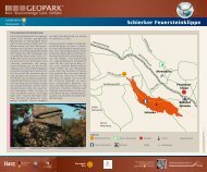
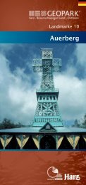
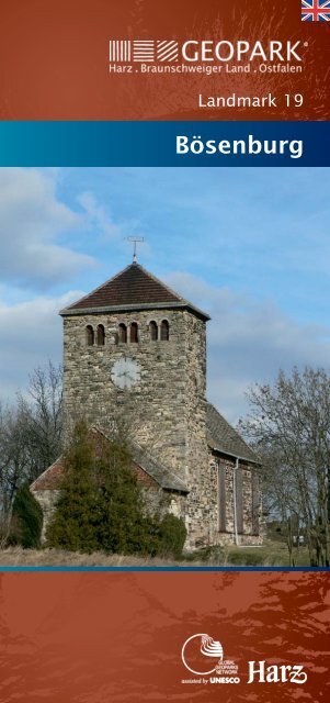
Landmark 19<br />
Bösenburg<br />
®
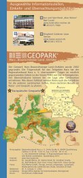
Networks of the Geoparks<br />
European Geoparks<br />
The Global Geopark Network is<br />
a worldwide association of various<br />
Geoparks, all of which pursue<br />
common go<strong>als</strong> under the auspices of<br />
the UNESCO.<br />
European Geoparks<br />
18<br />
Goslar<br />
3<br />
1 2<br />
4<br />
Osterode a.H.<br />
11<br />
5<br />
16<br />
A National Geopark is a clearly defi<br />
ned region, which conveys both<br />
geological history as well as the development<br />
of a cultural landscape. In<br />
addition, the institutions responsible<br />
for the Geoparks are actively involved<br />
in the protection of its geological heritage.<br />
The Geopark Harz · Braunschweiger Land · Ostfalen<br />
was founded in 2002. Its geographical position in<br />
Europe as well as the location of the individual<br />
landmark regions are depicted in the map above.<br />
®<br />
14<br />
Halberstadt<br />
13<br />
Königslutter<br />
8<br />
6 10<br />
Quedlinburg<br />
9<br />
15<br />
17<br />
Nordhausen Sangerhausen<br />
7 Sangerhausen<br />
12<br />
®<br />
19
1<br />
Stonemasonry school in Bösenburg<br />
Burgberg in Bösenburg<br />
The spur-like Burgberg ( 170 m above sea level ) in<br />
Bösenburg towers above the valley of the stream<br />
Fleischbach by 40 m and is crested by the Romanesque<br />
to early Gothic church St. Michael, widely visible as a<br />
landmark. A 15 ha hill-top settlement already existed<br />
in the Bronze Age on this historic place. In the course<br />
of Germanic colonisation a refuge fort with a burial<br />
place, a court place and religious centre originated<br />
here since the 4 th century – today they have long since<br />
disappeared. This fortress was esteemed to be centre<br />
of the Thuringian empire but was given up again, supposedly<br />
in the 11th century.<br />
The name “Bösenburg” probably goes back to the<br />
Thuringian King BISINUS ( around 460 ). We can get to<br />
the Burgberg from the Dorfstraße via a narrow driveway.<br />
Traces of the old underground sandstone<br />
Interior of the church St. Michael Tomb of Bösenburg sandstone<br />
extraction are visible on the hillside: bare rocks, a<br />
barred, almost blocked up mine mouth and dump<br />
material. The purpose of extraction of the Mid Bunter<br />
Age (Solling Formation, Chirotherian sandstone) was<br />
gaining ashlars. This popular light-coloured, easy to<br />
finish sandstone was processed mainly by local stonemasons<br />
in the village itself.<br />
Between 1620 and 1630 experts from Bohemian<br />
Olmütz immigrated, leading this craft to its heyday by<br />
their special skills; hence the term “Stonemasonry<br />
school of Bösenburg”. The sandstone is found in many<br />
local and regional buildings and works of art ( inter<br />
alia the church and the water mill of Bösenburg,<br />
tombs on the cemeteries of Bösenburg and Burgsdorf ).<br />
During the Second World War the bomb-proof hollows<br />
of the Friedrichsbruch served as a storing place for the<br />
inventory of the university and state library of Halle.<br />
The church can be visited on prior appointment.<br />
Contact: Gudrun Scheffler<br />
0049 34773 - 20390
2<br />
Sandstone<br />
Road shelf at Polleben<br />
Between Hermsdorf and Polleben the street runs<br />
through the Schlenzetal (valley). Here the stream crosses<br />
the resistive sandstone layers. Its valley which in<br />
Polleben still is wide and gently sloping narrowing to a<br />
width of now 50 m. A rock wall at the western roadside<br />
at the Steinmühle (mill) catches the eye. The outcrop –<br />
50 m long and 5 m high – shows pale yellow and red<br />
brown sediments of the bunter ( Hardegsen Formation ).<br />
The sloped layers fall with a tilt of about 15° south<br />
down to the centre of the Mansfelder Mulde, which is<br />
3 km away east of Polleben. There the bunter is already<br />
covered with Muschelkalk. The thin layers of sandstone<br />
and siltstone of the road shelf are not usable as ashlars.<br />
Thick-laying sandstone of the Solling Formation, however,<br />
was extracted in the old stone quarries 300 m to<br />
the south in the Schlenzetal.<br />
Road shelf<br />
3<br />
Mine mouth of the dewatering gallery<br />
Remains of the Mansfeld copper shale mining<br />
Entrance of Schlüsselstollen dewatering gallery<br />
A field path 400 m west of the end of the location<br />
Friedeburg towards Gerbstedt leads to the Neumühle<br />
( mill ). Not far from the building is the entrance of the<br />
Schlüsselstollen dewatering gallery. The strong flow conditions<br />
at the mine mouth show the importance of the<br />
construction begun already in the 18 th century and<br />
further driven from 1809 to 1879. It formed the basis of<br />
dewatering of the whole copper shale mining region. The<br />
collection of mining water was done over a channelshaped<br />
“scratching line”, hewn about 2 m deep into the<br />
rock laying below the copper shale layer. Pumping stations<br />
led the water collected due to the free fall on the<br />
deepest places of the mine workings to the dewatering<br />
gallery. The gallery west of Eisleben stretches to a length<br />
of 31.06 km via Klostermansfeld and Gerbstedt to<br />
Friedeburg and dewaters over the Schlenze into the Saale.
4<br />
View to the “Mansfeld Pyramids”<br />
Hoyerstein at Welfesholz<br />
Even from far away three impressive grey cone-shaped<br />
elevations strike the eye, they mark the relief of the<br />
Mansfelder Land distinctively. They are deposited<br />
large dumps of the 20 th century, <strong>als</strong>o called the<br />
“Mansfeld Pyramids”, witnessing 800 years of copper<br />
shale mining. The three mine dumps are well visible<br />
from the Hoyerstein (<strong>als</strong>o “Porous stone”). We can<br />
reach it via the track leading from the southern<br />
outskirts of Welfesholz towards east. The Hoyerstein<br />
is remindful of the battle of Welfesholz in 1115, in<br />
which troops of the rebellious ruler under the<br />
command of the Duke of Saxony LOTHAR VON<br />
SÜPPLINGENBURG († 1137) defeated the units of Emperor<br />
HEINRICH V. († 1125). The leader of the imperi<strong>als</strong>, Count<br />
HOYER VON MANSFELD, lost his life in the duel there. The<br />
mine dump of the sunk Fortschrittschacht (mine)<br />
south of Volkstedt (1909 – 1967, former Wolf-Schacht)<br />
is<br />
Mansfeld Pyramids Hoyerstein ( Tertiary quartzite )<br />
311 m above sea level and about 140 m high. The peak<br />
of the mine dump of the Ernst-Thälmann-Schacht<br />
(1915 – 1962, former Vitzthum-Schacht ) north of<br />
Volkstedt is about 350 m above sea level and overtops<br />
the surrounding area by 130 m. The Otto-Brosowski-<br />
Schacht (1906 – 1969, former Paul-Schacht) is in the<br />
east of Augsdorf. Its mine dump at 283 m above sea<br />
level and about 100 m height takes the third rank in<br />
this scope. These three point cone mine dumps,<br />
together with the detached block in the roof mine<br />
dumps of the 19 th and the 20th century, form the third<br />
and last mine dump generation. The few low mine<br />
dumps of the second generation are only up to 30 m<br />
high and originate from the 18 th century. The<br />
beginnings of mining, however, are marked by<br />
numerous hilly small dumps up to 4 m high. Due to<br />
the heavy metal content of the rocks the mine dumps<br />
are uncovered by vegetation.<br />
The memorial place of the battle of Welfesholz in Welfesholz,<br />
Dorfstraße 36 can be visited by appointment.<br />
Contact: Edgard von Stromberg, 0049 34783-31103
Geologic Overview<br />
The area of the Landmark 19 is in the south-eastern<br />
Harz foreland and stretches partly to the Saale. With its<br />
wide scarcely structured tablelands, the steppic fields<br />
and meadows and lack of forests, the landscape offers<br />
only little change. The conditions below ground are<br />
more exciting. The geologic 3D model shows a large<br />
key-shaped structure: the Mansfelder Mulde. It arose in<br />
the Upper Tertiary about 20 million years ago. The<br />
series of deposits began with thick formations of the<br />
Upper Carboniferous and the Rotliegend 310 million<br />
years ago. It is mainly erosion debris of the prior folded<br />
Variscan mountains. It gathered in alluvial plains<br />
fed by rivers and mostly consists of red sandstones. In<br />
the following there are 258 – 251 million years old sediments<br />
of the Zechstein with the copper shale loam on<br />
the basis and up to 300 m thick sulphate and salt rocks<br />
lying above.<br />
These soluble rocks arose by several changes of flooding<br />
and evaporation of a flat sea. The Triassic follows<br />
above it beginning with sandy and argillaceous river<br />
and lake sediments of the 251 – 243 million years old<br />
Bunter. Their partly compact sandstones were surface<br />
mined in numerous quarries and can be seen at many<br />
buildings. The deposited Muschelkalk (Lower and<br />
Middle Triassic, up to about 239 million years) is only<br />
spread in the centre of the syncline between Polleben<br />
and Schochwitz. Formations of the Tertiary (65 – 2.6<br />
million years, brown coal, sand, d, gravel) have remained<br />
in the moats of the saddle structures uctures as well as in the<br />
Tertiary<br />
Muschelkalk<br />
Buntsandstein<br />
Zechstein<br />
Rotliegend,<br />
Upper Carboniferous<br />
Basement Rock
local depression areas, arisen by leaching Zechstein in<br />
particular. The largest Tertiary deposits are extracted<br />
in the brown coal pit Amsdorf. During the Ice Age<br />
( Pleistocene, beginning 2.6 million years ago ) the region<br />
was twice covered by Scandinavian ice of glaciers.<br />
The remains of the glaciers and their melting water<br />
( boulder clay, sand, gravel, clay ) cover the area widely.<br />
A thick loess layer was formed by wind erosion, on<br />
which fertile black earths developed. The lakes of the<br />
Mansfelder Land arose only during the post-glacial<br />
warm period (Holocene, since 11,600 years) lasting<br />
until today in the depression areas over the leached<br />
Zechstein salt.<br />
The changing geological conditions have heightened<br />
mining since time immemorial. The copper shale only<br />
about 40 cm thick had special economic importance.<br />
Intensively mined for 800 years, it made the Mansfelder<br />
Mulde well known as a mining area. First beginnings of<br />
mining even go back to the Bronze Age. Early mining<br />
activities started from the surface and then followed<br />
the ore-bearing shale layer to more and more deeper<br />
levels.<br />
The deepest mining site was at Bösenburg 995 m<br />
underground. The three massive point cone mine<br />
dumps are witnesses of the last phase of mining, which<br />
came to an end with natural depletion of deposits in<br />
1969. All in all 80 million tons ton of ore were extracted,<br />
summing up to 2 million tons<br />
of copper.
Glossary<br />
Landmarks are widely visible or particularly wellknown<br />
ground points or places serving for a fi rst orientation<br />
in the largest Geopark of Europe giving its name<br />
to one of its part areas.<br />
Geopoints are points of special interest. The geologic<br />
history and the development of the nature and culture<br />
landscape can be seen and conveyed on them. Geopoints<br />
of the area of one landmark are continuously<br />
numbered and can be connected to individual geo-routes.<br />
Geopoint 1 is always the place of the eponymous<br />
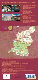
landmark.<br />
The map section helps you to plan your personal<br />
geo-route around Bösenburg.<br />
Order leafl ets in English<br />
Information en français<br />
www.harzregion.de<br />
6<br />
Publishing of map with the kind permission of the Verwaltungs-Verlag<br />
Munich www.stadtplan.net licence no. 11-02-10<br />
4<br />
10<br />
2 1<br />
7<br />
9<br />
11<br />
8<br />
3<br />
5
5<br />
Crude montan wax for the world<br />
Surface mining Amsdorf<br />
The open brown coal pit of Amsdorf lies between<br />
Röblingen and Wansleben on the tableland south of the<br />
Salziger See (lake). Geologically the area already counts<br />
to the Querfurter Mulde which connects to the<br />
Mansfelder Mulde in the south and is separated from<br />
it by the Teutschenthaler Sattel. Underground salt leaching<br />
and salt migration have created a large depression<br />
filled with rich formations of the Tertiary (brown<br />
coal, sand, clay), overlain by a cover of glacial sediments<br />
(sand, gravel, stones).<br />
A lookout is on the southern side of the pit, which<br />
can be reached from Stedten driving estwards. The<br />
production facilities of the company Romonta<br />
(“Rohmontanwachs aus Amsdorf” – crude montan<br />
wax from Amsdorf) are seen in the north. The pit in<br />
Amsdorf has been in operation since 1958.<br />
View from the lookout of the surface mine<br />
Compactor<br />
Here about 500,000 t of coal are extracted every year.<br />
The coal only secondarily serves the generation of energy.<br />
It is mainly used for producing crude montan wax,<br />
extracted by special processes and delivered to<br />
60 countries. It is contained in glosses, lubricants and<br />
shoe polishes, but can <strong>als</strong>o be used in the asphalt industry<br />
and in founding. We cross the pit using the street<br />
in northern direction.<br />
On the right we can see revegetated extraction areas<br />
and behind that the rising point cone mine dump of the<br />
former potash mine Teutschenthal. Turning left to<br />
Unterröblingen we reach a car park at the Romonta<br />
main gate. The open air exhibition “Rolling material“ in<br />
front of the company fence shows the technical history<br />
of the montan wax global market leader (locomotives,<br />
special waggons, extractors and other items), which<br />
can be visited any time.<br />
Company tours are offered for groups.<br />
Contact: Detlef Berger, public relations<br />
0049 34601 - 40158
6<br />
Education for miners ( Eisleben )<br />
Old mining school and miner’s fountain<br />
Due to the development of mining the demand for<br />
head miners and foremen for the metallurgical works<br />
in the Mansfeld copper shale mining was very high.<br />
Already in 1719 the shareholder of the time decided<br />
to grant young miners a scientific education according<br />
to the Freiberg model. At first the tuition in Eisleben<br />
was done sporadically as required and with regard to<br />
the possibilities. In 1780, the electoral Saxon<br />
government decided to offer regular lessons in<br />
Eisleben. 18 years later the Eisleber Bergschule (Mining<br />
School of Eisleben) was founded in which eight<br />
trainees could start the apprenticeship annually till<br />
1808. The costs for the education were borne by the<br />
shareholder of Mansfeld. The school was open to<br />
other students, but they had to cover the costs<br />
themselves. Day-to-day school life was not comparable<br />
with today’s. The apprenticeship took 4 years<br />
Miner’s fountain Kamerad Martin<br />
beginning with three lessons a week under the<br />
condition that the trainees had to work daily in the<br />
respective company. Various monuments in the town<br />
of Eisleben which was first mentioned in the records<br />
in 994 commemorate 800 years of copper shale<br />
mining such as the “Kamerad Martin” on the Breiter<br />
Weg or the Knappenbrunnen (Miner’s fountain )<br />
opposite the former old mining school. The fountain<br />
was founded by the Mansfeld-Kombinat (combine) in<br />
1983 and created by the sculptor WOLFGANG DREYSSE<br />
from Quedlinburg. Eisleben is <strong>als</strong>o famous as the<br />
place of both birth and death of MARTIN LUTHER<br />
(1483 – 1546). Luther’s father was a master smelter<br />
and owner of several mines and metallurgical works.<br />
Count ALBRECHT IV. VON MANSFELD († 1560), a friend of<br />
Luther, founded the new town of Eisleben with the<br />
church St. Anna, in which a stone picture bible, unique<br />
in Europe, can be visited.
7<br />
Slag bricks<br />
Corn bottles in Friedeburgerhütte<br />
The so called corn bottles are on the left side of the<br />
street entering the village from Gerbstedt. These are<br />
large, masoned tanks made of slag stones built<br />
between 1825 and 1841. The shareholder of the<br />
Kupferkammerhütte (metallurgical works) had it built<br />
for the families working there.<br />
They were used for storing bonus crop. The corn<br />
bottles have a clear diameter of 4.5 m, each is 9.5 m<br />
high and below surface in loess loam. As the opening<br />
on the top of the bottles was about 1 m below the<br />
surface and was closed with a slab the inside temperature<br />
remained constant. The slag stonework protected it<br />
from humidity and vermin. Relics of only 3 out of<br />
10 corn bottles have survived. They were secured and<br />
reconstructed between 1995 and 2001.<br />
Corn bottle View from the gallows column to the Süßer See<br />
8<br />
Lakes of Mansfeld<br />
Gallows column at the Süßer See<br />
Two lakes marked the natural scenery of the region for<br />
a long time: the Salziger (salty) and the Süßer (sweet)<br />
See. They were the “blue eyes” of the Mansfelder Land.<br />
Their formation is closely connected with the land<br />
depression by leaching of salt of the Zechstein. 8,000<br />
years ago the Süßer See began to form. It stretches from<br />
Seeburg to Lüttchendorf and is about 4.9 km long and<br />
just less than 1 km wide at Aseleben. Its northern bank<br />
consists of Lower Bunter and is mainly used for wine and<br />
fruit growing. The gallows column is on the elevation<br />
north of the camping site Seeburg. These are the<br />
remains of the gallows base made of field stones in<br />
1720. From there you will have a wonderful view to the<br />
lake and the locality Seeburg with the Renaissance castle.<br />
We reach the elevation from the car park at the northern<br />
beach via the street through the settlement of<br />
weekend cottages.
9<br />
Salziger See (salty lake)<br />
Lookout at Röblingen am See<br />
The former Salziger See (salty lake) stretched between<br />
Rollsdorf, Amsdorf and Unterröblingen to Röblingen.<br />
Today it is crossed by the B 80, used as grass and arable<br />
field landscape. We can find the lookout short before<br />
entering Röblingen coming from Aseleben. First marine<br />
deposits already arose in the late glacial 14,000 years<br />
ago but only in the Holocene the extended lake area<br />
developed 11,600 years ago.<br />
With its 840 ha, the Salziger See was the largest lake of<br />
Middle Germany about 300 years ago. Due to the waterworks<br />
of the Mansfeld copper shale mining the sea level<br />
sank several times. After strong water ingress in the<br />
mine workings in 1892, the lake was finally dried up in<br />
1894. Remains of the Salziger See are the Binder- and<br />
Kerner See south of Rollsdorf as well as some smaller<br />
lakes north of Röblingen.<br />
View to the relics of the Salziger See Museum Gerbstedt - former convent building<br />
10<br />
Local and mining history<br />
Museum Gerbstedt<br />
The small town of Gerbstedt as a cradle of medieval<br />
copper shale mining is on the northern edge of the<br />
Mansfelder Mulde. Worth visiting are especially the<br />
historic centre of the locality with the Renaissance<br />
townhall (1566) and the town church close by (1739). A<br />
part of the former convent building is today used as a<br />
community centre and has a small museum inside.<br />
Here the local and mining history comes alive such as<br />
a model of the convent of Gerbstedt, a model of the<br />
Otto-Brosowski-Schacht (mine) and some miner’s uniforms.<br />
Strolling through the town we see numerous<br />
miniatures made of painted concrete created by the<br />
artist GÜNTHER BEINERT from Gerbstedt. These are mostly<br />
imaginative replications of regional fortresses and castles<br />
but <strong>als</strong>o original craftsmen as well as miners and<br />
smelters.<br />
The museum is open on Saturdays and Sundays from 2 pm – 5 pm<br />
and on appointment. Contact: Ulrich Elster<br />
0049 34783 - 27502 or 0049 152 - 29 138507
11<br />
Dr. Otto Kleinschmidt<br />
Dederstedt<br />
A memorial stone for DR. OTTO KLEINSCHMIDT<br />
( 1870 - 1954 ) is in front of the vicarage in Dederstedt.<br />
Since 1899 he worked as a parish priest in nearby<br />
Volkmaritz. In 1910 he changed to Dederstedt. He was<br />
a meticulous and tireless ornithologist. Very soon ornithology<br />
made him well known far across the village. In<br />
1905 he published his journal “FALCO” and the monograph<br />
series “Berajah – Zoographia infinita”. In these<br />
texts he continuously attacked existing views on zoological<br />
systematics and the Darwinian theory of evolution.<br />
His best known work is the field guide “Singvögel<br />
der Heimat” ( local oscine birds ). KLEINSCHMIDT probably<br />
got the inspiration for his natural bird drawings <strong>als</strong>o<br />
from Laweketal at Dederstedt. There an information<br />
board shows which bird species can be watched at<br />
which time.<br />
Memorial stone for Dr. Otto Kleinschmidt Drawing of Dr. Otto Kleinschmidt<br />
The grey wagtail drawn by KLEINSCHMIDT bred at the vicarage<br />
in 1931. Even today two of his original mounted<br />
specimens can be seen in the church of Dederstedt. In<br />
1926 KLEINSCHMIDT left Dederstedt to take over the leadership<br />
of the newly founded church research home for<br />
philosophy in Wittenberg. In July 1998 the citizens of<br />
Dederstedt unveiled the monument for DR. OTTO<br />
KLEINSCHMIDT.<br />
Matching the opinionated priest and ornithologist they<br />
chose a very hard Tertiary quartzite as memorial stone.<br />
These rocks arose during the Tertiary ( 65 – 2.6 mio<br />
years ago ) from sands, glued together by silica due to<br />
the subtropical climate. Numerous quartzite blocks<br />
were laid open during the Ice Age by the effect of scraping<br />
glaciers and taken to the surface from their point<br />
of origin. They were used for cultic purposes and as<br />
mill stones.<br />
The church St. Susanna can be visited by appointment.<br />
Contact: Richarda Barth<br />
0049 34773 - 21115
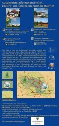
Stops for me<strong>als</strong> & accommodations<br />
A<br />
B<br />
C<br />
A Hotel An der Klosterpforte Eisleben<br />
www.klosterpforte.com<br />
0049 3475 - 71440<br />
B Strandhotel Zahn Aseleben<br />
www.strandhotel-zahn.de<br />
0049 34774 - 28069<br />
C Gasthof Zahn Stedten<br />
www.gasthof-zahn.de<br />
0049 34774 - 70090<br />
The Regionalverband Harz is a nonprofi t association of<br />
the administrative districts of Goslar, Harz, Mansfeld-<br />
Südharz, Osterode am Harz and Nordhausen. It supports<br />
nature and environmental conservation as well as culture<br />
and is supported by the network of its far more than 100<br />
sustaining members. The aims will be realised by the organising<br />
institution of nature parks in the Harz region. As<br />
shareholder of the Geopark Harz•Braunschweiger Land.<br />
Ostfalen GbR, founded in 2004, the Regionalverband<br />
Harz is in addition responsible for the southern part of<br />
the homonymous Geopark. Its Partner association FEMO<br />
in Königslutter cares for the northern part. The Geopark<br />
Harz•Braunschweiger Land•Ostfalen has been a member<br />
of the European and Global Geoparks network under<br />
the patronage of the UNESCO since 2004.<br />
Publisher: Regionalverband Harz e. V., Hohe Straße 6, 06484 Quedlinburg<br />
0049 3946 - 96410, E-Mail: rvh@harzregion.de<br />
1st digital-edition, © Regionalverband Harz e. V.<br />
All rights reserved. Quedlinburg 2012<br />
Internet: www.harzregion.de<br />
Authors: Dr. Carl-Heinz Friedel, Christiane Linke, Isabel Reuter, Konrad Schuberth<br />
Fotos: Dr. Carl-Heinz Friedel, Dr. Klaus George, Christiane Linke,<br />
Isabel Reuter, Konrad Schuberth<br />
Translation: Silvia Baldauf<br />
Editor:<br />
Geologic<br />
Dr. Klaus George, Isabel Reuter<br />
3D model: Dr. Ivo Rappsilber<br />
Design: Design Office Agentur für Kommunikation, Wernigerode