
Create successful ePaper yourself
Turn your PDF publications into a flip-book with our unique Google optimized e-Paper software.
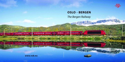
www.nsb.no<br />
Foto: Rolf M. Sørensen<br />
<strong>OSLO</strong> - <strong>BERGEN</strong><br />
The Bergen Railway
THE <strong>BERGEN</strong> RAILWAY WAS OFFICIALLY OPENED IN A CEREMONY AT VOSS ON 27<br />
NOVEMBER 1909 BY KING HAAKON. THE KING HELD AN ENTHUSIASTIC INAUGURATION<br />
SPEECH, DESCRIBING THE NEW RAILWAY LINE BETWEEN <strong>OSLO</strong> AND <strong>BERGEN</strong> AS “OUR<br />
GENERATION’S MASTERPIECE”.<br />
WHILE THE LINE WAS BEING PLANNED NORWAY WAS STILL IN A UNION WITH SWEDEN,<br />
AND FOR ADMINISTRATIVE PURPOSES IT WAS IMPORTANT FOR THE UNITED<br />
MONARCHY TO IMPROVE TRANSPORT CONNECTIONS BETWEEN MAJOR CITIES.<br />
NORWAY’S CAPITAL, WHICH WAS CALLED KRISTIANIA UNTIL ITS NAME WAS CHANGED<br />
TO <strong>OSLO</strong> IN 1925, WAS TO BE THE HUB OF THE NORWEGIAN RAIL NETWORK, WITH<br />
CONNECTIONS TO NEIGHBOURING COUNTRIES.<br />
The Bergen Railway<br />
– a brief history<br />
P<br />
lanning a railway across<br />
the Hardangervidda<br />
mountain range was no small<br />
task. At one point, more precisely<br />
at Taugevatn, the line is<br />
1,301 metres above sea level,<br />
making the Bergen Railway<br />
the highest and most challenging<br />
line in northern<br />
Europe. Time and again, the<br />
railway workers faced the<br />
power of nature. At one time,<br />
in order to keep the trains running,<br />
the line had 27 kilometres<br />
of snow sheds to protect<br />
it from snowdrifts, 60 kilometres<br />
of snow screens and 184<br />
tunnels in addition to 55 stations.<br />
The workers who built the<br />
Bergen Railway …<br />
A railway builder was known<br />
as a “rallar”, equivalent to the<br />
English “navvy”. The word “rallar”<br />
originally meant someone<br />
who pushed a trolley or<br />
wheelbarrow. More than a<br />
thousand navvies could be<br />
working on the line at any one<br />
time. In fact, during the busiest<br />
construction period, the number<br />
of workers totalled 2,200.<br />
Over the entire project period,<br />
some 15,000 workers were<br />
employed to build the Bergen<br />
Railway.<br />
The primitive camps where<br />
the workers lived were a paradise<br />
for lice and it was a daily<br />
battle to keep these vermin at<br />
bay. Some believed that snuff<br />
in the bedclothes would keep<br />
the lice away, while others<br />
carefully heated dynamite and<br />
rubbed it on their skin.<br />
Battling the weather<br />
The Bergen Railway is subject<br />
to some of the most extreme<br />
weather of any European railway.<br />
In order to keep the<br />
tracks open, the snow must be<br />
cleared continuously throughout<br />
the winter. Today, diesel<br />
engines fitted with rotary<br />
snowploughs are used to clear<br />
the tracks. A cascade of snow<br />
is flung up to 40 metres into<br />
the air. You can imagine how<br />
difficult this job was in the<br />
early 20th century, when the<br />
rotary ploughs were powered<br />
by steam. The steam-powered<br />
plough was in still in use well<br />
into the 1970s. It is not unusual<br />
to see 4–5 metre deep<br />
snowdrifts in places such as<br />
Finse after a blizzard. In 1913,<br />
the snow was piled 8 metres<br />
high on the track at Finse!<br />
The Bergen Railway is one of<br />
Europe’s most popular lines<br />
with more than half a million<br />
passengers passing through<br />
Finse every year.The trains are<br />
among <strong>NSB</strong>’s most modern so<br />
just relax and enjoy the journey<br />
and admire the spectacular<br />
views.You can enjoy a meal in<br />
the restaurant car, let the children<br />
play in the family car or<br />
just lean back and let your mind<br />
wander while the Norwegian<br />
countryside flies by. Doesn’t it<br />
sound tempting?<br />
2 3
Foto: Svein Ulvund<br />
4<br />
Try it and you<br />
are guaranteed a<br />
fascinating journey!<br />
Travelling makes you hungry and food always tastes great on the train.<br />
Some passengers prefer to bring their own food and drink, while others<br />
want to try the refreshments served on the train. Most of Norway’s regional<br />
railways serve refreshments either in a restaurant car (<strong>NSB</strong> MENY Kafé)<br />
or have a snack machine (<strong>NSB</strong> MENY Automat).<br />
5
Where does<br />
the Bergen Railway go?<br />
THIS MAY SEEM LIKE A STRANGE QUESTION AS THE <strong>BERGEN</strong> RAILWAY<br />
OBVIOUSLY RUNS BETWEEN <strong>OSLO</strong> AND <strong>BERGEN</strong>. THAT IS CORRECT,<br />
BUT IN FACT, THE <strong>BERGEN</strong> RAILWAY IS COMPRISED OF SEVERAL<br />
LINES THAT WERE ONCE INDEPENDENT RAILWAY COMPA-<br />
NIES. THE FIRST STRETCH OF LINE BETWEEN <strong>OSLO</strong> S<br />
STATION AND DRAMMEN IS THE DRAMMEN RAILWAY,<br />
WHILE THE NEXT DISTANCE FROM DRAMMEN TO<br />
HØNEFOSS IS THE RANDSFJORD RAILWAY. THE<br />
<strong>BERGEN</strong> RAILWAY ACTUALLY STARTS AT<br />
HØNEFOSS BUT IT DOES NOT RUN ALL THE<br />
WAY TO <strong>BERGEN</strong> BUT ONLY TO VOSS.<br />
THE LAST STRETCH OF LINE, FROM<br />
VOSS TO <strong>BERGEN</strong>, IS IN ACTUAL<br />
FACT CALLED THE VOSS<br />
RAILWAY. ALTHOUGH IT<br />
DOESN’T MATTER IN<br />
PRACTICE, IT IS AN<br />
INTERESTING<br />
CURIOSITY.<br />
Foto: (gutt på tog) Øivind Haug Foto: (Tog i vindu) Rolf M. Sørensen<br />
A<br />
s the train departs from<br />
Oslo S station, you leave<br />
behind a pulsating city with all<br />
the attractions you’d expect of a<br />
capital.The landscape changes<br />
between urban and rural until<br />
you reach some of wildest<br />
nature accessible by train anywhere<br />
in the world. Some of the<br />
station buildings along the<br />
route have a unique architectur-<br />
Bergen<br />
Stavanger<br />
Voss<br />
Myrdal<br />
Flåm<br />
al style and are worth a closer<br />
look.<br />
The journey takes you through<br />
some of eastern Norway’s most<br />
fertile agricultural areas before<br />
you reach the valley of<br />
Hallingdal. As you pass lake<br />
Krøderen you can enjoy the<br />
magnificent views of the mountain<br />
of Norefjell.The train continues<br />
to Gol where it begins its<br />
Finse<br />
Geilo<br />
Gol<br />
Nesbyen<br />
Drammen<br />
Hønefoss<br />
Oslo<br />
ascent into the mountains. Once<br />
the train passes Geilo the terrain<br />
becomes more mountainous.<br />
The railway line climbs more<br />
than 1,000 metres over a distance<br />
of just under 100 kilometres.<br />
Once you reach the top of the<br />
mountain the beautiful landscape<br />
will take your breath<br />
away. It is a truly unforgettable<br />
experience!<br />
After passing the highest point<br />
of any railway in northern<br />
Europe, the train begins its<br />
descent. Once you reach Myrdal<br />
you are in western Norway.<br />
Other places of interest on the<br />
journey are the Gravehalsen<br />
tunnel, the beautiful valley of<br />
Raundalen,Voss, Dale and Arna,<br />
before the train pulls into the<br />
old Hanseatic city of Bergen, the<br />
capital of western Norway.<br />
You can refer to this brochure<br />
during your journey for brief<br />
descriptions of stations and<br />
sights along the Bergen Railway.<br />
<strong>NSB</strong> wishes you a nice trip!<br />
6 7
Oslo S<br />
Oslo, also known as “the Tiger<br />
city”, is the capital of Norway<br />
and home to around half a<br />
million people. It is a bustling<br />
city with plenty of opportunities<br />
for cultural experiences<br />
and leisure pursuits in all seasons.<br />
Oslo Sentralstasjon (Oslo S) is<br />
Norway’s biggest railway station.<br />
It has been modernised<br />
in recent years and in addition<br />
to traditional railway services<br />
the station has a choice of<br />
shops and restaurants. There<br />
has been station on this site<br />
since Norway’s first railway,<br />
between Kristiania (later Oslo)<br />
and Eidsvoll, opened in 1854.<br />
The station’s name was<br />
changed from Oslo Ø (east) to<br />
Oslo S in 1981. The station was<br />
extended with new platforms<br />
and a new concourse in 1999.<br />
Altitude 3 metres above sea level<br />
Distance from Oslo 0.0 km<br />
Distance from Bergen 471.2 km<br />
The Oslo tunnel<br />
Length 3.6 km. Opened in<br />
1980.<br />
Skøyen<br />
This is an elevated station,<br />
built in connection with the<br />
dual track project. The characteristic<br />
platform building is in<br />
the colouristic style.<br />
Altitude 8 metres above sea level<br />
Distance from Oslo 3.3 km<br />
Distance from Bergen 467.9 km<br />
Lysaker<br />
<strong>NSB</strong> trains only stop for boarding<br />
passengers at this station.<br />
The plan is to increase the<br />
number of platforms at the<br />
station to four. Located near<br />
Oslo’s former airport of<br />
Fornebu, which has now<br />
become an IT business park<br />
for companies such as Telenor<br />
etc. Lysaker is also a seaport.<br />
Altitude 13 metres above sea level<br />
Distance from Oslo 6.0 km<br />
Distance from Bergen 464.2 km<br />
Sandvika<br />
Here the Drammen Railway<br />
splits into two lines: a new<br />
track with a non-stop connection<br />
to Asker through two new<br />
tunnels and the old track,<br />
which serves the suburbs<br />
between Oslo and Asker.<br />
Altitude 12 metres above sea level<br />
Distance from Oslo 14.1 km<br />
Distance from Bergen 457.1 km<br />
Foto: Giulio Bolognese/VisitOslo<br />
Asker<br />
Most <strong>NSB</strong> trains stop for boarding<br />
at Asker.The station was<br />
extensively refurbished in connection<br />
with the new dual track<br />
from Sandvika.The Spikkestad<br />
line branches off at Asker. Just<br />
before Asker station, on the<br />
right, you can see Skaugum, the<br />
residence of the Norwegian<br />
Crown Prince and Princess.<br />
Altitude 105 metres above sea level<br />
Distance from Oslo 23.8 km<br />
Distance from Bergen 447.4 km<br />
Lieråsen tunnel<br />
Length 10.7 km. The tunnel<br />
was opened in 1973.<br />
Bridges across the river<br />
Drammenselva<br />
These are the longest railway<br />
bridges in Norway, measuring<br />
340 and 451 metres respectively.<br />
They replaced the old<br />
bridges in 1996.<br />
Drammen<br />
The station opened in 1866 in<br />
connection with the completion<br />
of the Randsfjord Railway<br />
between Drammen and<br />
Randsfjord. On the left as you<br />
approach Drammen you can<br />
see Norway’s biggest port for<br />
car imports.The city of Drammen<br />
has a population of 50,000, or<br />
100,000 including the surrounding<br />
districts. Drammen has a<br />
connection to the Vestfold<br />
Railway. Bragernes torg, the<br />
city’s main square, is the biggest<br />
in northern Europe. It has undergone<br />
extensive renovation in<br />
recent years and in 2005 was<br />
awarded a prize for urban renewal<br />
and development.After<br />
Drammen, the train travels<br />
through Nedre Eiker and Øvre<br />
Eiker. In the past, various industries<br />
were situated on the river,<br />
and some of the old buildings<br />
remain.<br />
Altitude 2 metres above sea level<br />
Distance from Oslo 52.8 km<br />
Distance from Bergen 418.4 km<br />
Gulskogen<br />
The station is a brick building<br />
in the new baroque style with<br />
corner pilasters and a hip roof.<br />
The nearby Gulskogen manor<br />
is a part of Drammen museum.<br />
The manor was built as a country<br />
respite in 1804 and has one<br />
of Norway’s most well-preserved<br />
classical gardens. The<br />
manor has a 265-metre long<br />
lime tree avenue and the country’s<br />
only preserved maze<br />
made from hazel trees.<br />
Altitude 8 metres above sea level<br />
Distance from Oslo 55.2 km<br />
Distance from Bergen 416 km<br />
Hokksund stasjon<br />
The station opened in 1866 in<br />
connection with the completion<br />
of the Randsfjord Railway.<br />
The station is a stop for <strong>NSB</strong><br />
trains on the Bergen Railway<br />
and the line serving the south<br />
coast of Norway, as well as<br />
local trains. At this point, the<br />
river is just 1 metre above sea<br />
level which means small ships<br />
can sail as far as Hokksund. In<br />
1961 a whale was spotted in<br />
the river here. The south coast<br />
train line branches off to the<br />
left at Hokksund.<br />
Altitude 8 metres above sea level<br />
Distance from Oslo 70.2 km<br />
Distance from Bergen 401 km<br />
8 9
Vikersund<br />
The station opened in 1866 in<br />
connection with the completion<br />
of the Randsfjord Railway.<br />
The station is similar to the<br />
one in Asker. It has been<br />
extended and partly refurbished.<br />
Part of the original roof<br />
overhang remains intact, as<br />
does the station interior.<br />
As you approach Vikersund<br />
station you can see the giant<br />
ski jump on the right. The<br />
record jump is 219 metres, set<br />
by the Austrian Roland Müller<br />
in 2004. Vikersund is also well<br />
known for the psychiatric hospital<br />
Modum Bads<br />
Nervesanatorium and the<br />
Krøder vintage railway.<br />
Altitude 67,1 metres above sea level<br />
Distance from Oslo 84.5 km<br />
Distance from Bergen 386.7 km<br />
Hønefoss<br />
The station opened in 1866 in<br />
connection with the completion<br />
of the Randsfjord Railway.<br />
The present building dates<br />
back to the opening of the<br />
Bergen Railway in 1909. Since<br />
the late 1980s, most trains go<br />
via Drammen rather than Roa.<br />
Although the distance via<br />
Drammen is 23 km longer, the<br />
travel time is the about the<br />
same.<br />
Hønefoss has been a centre for<br />
trade and industry since the<br />
17th century. The town and<br />
the waterfall after which it was<br />
named are on the right as you<br />
approach the station. The 216metre<br />
stone arch bridge for<br />
the Roa–Hønefoss train line is<br />
also on the right. If you keep<br />
looking right, a couple of minutes<br />
after the train leaves the<br />
station you can see the Iron<br />
Age site of Hringariki, designated<br />
as Buskerud county’s<br />
Millennium Site. The longhouse<br />
at Hringariki is a replica<br />
of what experts believe these<br />
dwellings looked like.<br />
Altitude 97 metres above sea level<br />
Distance from Oslo 89.5 km<br />
Distance from Bergen 381.7 km<br />
Sokna<br />
Sokna station was built in<br />
1910 in the art nouveau style<br />
first used at Flikkeid station on<br />
the Flekkefjord Railway.<br />
Sokna, along with Nesbyen, is<br />
famous for being one of the<br />
coldest places in Norway in<br />
winter and one of the warmest<br />
in summer.<br />
Altitude 143 metres above sea level<br />
Distance from Oslo 111.9 km<br />
Distance from Bergen 359.3 km<br />
Haversting tunnel<br />
This 2,300-metre tunnel was<br />
the second-longest on the<br />
Bergen Railway in 1909.<br />
Ørgenvika<br />
Look out of the left window<br />
and enjoy the magnificent<br />
view of the Norefjell mountain<br />
and lake Krøderen. Norefjell is<br />
a popular winter sports resort.<br />
During the 1952 Winter<br />
Olympics in Oslo, many of the<br />
competitions took place here.<br />
Altitude 269 metres above sea level<br />
Distance from Oslo 128.2 km<br />
Distance from Bergen 343 km<br />
Gulsvik<br />
Gulsvik station was completed<br />
in 1908 and built in the socalled<br />
“Sirnes style”, found on<br />
the Bergen Railway,<br />
Egersund–Flekkefjord line and<br />
Arendal–Åmli line. The original<br />
lay-out has been preserved:<br />
the ground floor had a large<br />
waiting room and a ticket<br />
office as well as a telegraph<br />
room, luggage locker room<br />
and a staircase in the back. The<br />
station had a restaurant until<br />
1935. The grounds with the<br />
station building and the surrounding<br />
park form an important<br />
part of local heritage and<br />
railway history. The train now<br />
enters the valley of Hallingdal.<br />
The road tunnel on your left,<br />
known as the gateway to<br />
Hallingdal, was a rail tunnel<br />
until the new track was laid in<br />
1972.<br />
Altitude 146 metres above sea level<br />
Distance from Oslo 140.8 km<br />
Distance from Bergen 330.4 km<br />
Flå<br />
Flå station was completed in<br />
1907 and has been preserved<br />
in its original form. The station<br />
is 1 km from the centre of Flå<br />
and is unstaffed. It is included<br />
in the preservation plan for<br />
railway buildings drawn up by<br />
the Norwegian state railway<br />
company, <strong>NSB</strong>. Flå has the<br />
biggest timber industry in the<br />
valley of Hallingdal and is just<br />
a short distance away from<br />
Vassfaret bear park.<br />
Altitude 155 metres above sea level<br />
Distance from Oslo 152 km<br />
Distance from Bergen 319 km<br />
Nedre Hallingdal<br />
The terrain in lower Hallingdal<br />
is challenging and the track<br />
twists and turns and passes<br />
through several short tunnels.<br />
The river is on the left all the<br />
time.<br />
10 11
Austvoll water tower<br />
Austvoll is one of the smaller<br />
stations on the Bergen<br />
Railway. It was built with a<br />
waiting room and ticket office<br />
but plans for a freight building<br />
were dropped. The most interesting<br />
building at Austvoll is<br />
the water tower, constructed<br />
from unpolished brick and rich<br />
in detail. This is the only water<br />
tower left on the Bergen<br />
Railway. It was selected as one<br />
of Flå municipality’s cultural<br />
monuments in 1997 and is<br />
also included in <strong>NSB</strong>’s preservation<br />
plan.<br />
Nesbyen<br />
Nesbyen station was opened<br />
in 1907 and the entire original<br />
complex has been preserved.<br />
The station is unstaffed. Nesbyen,<br />
along with Sokna, is one<br />
of the coldest places in the<br />
county of Buskerud in winter<br />
and one of the warmest in<br />
summer. In the summer of<br />
1970, the temperature reached<br />
a record 35.6 degrees Centigrade.<br />
Nesbyen is an alpine ski<br />
resort with bus connections to<br />
Tunhovd and Myking.<br />
Svenkerud<br />
Svenkerud bridge is where the<br />
Bergen Railway crosses the<br />
river Hallingdalselva. The<br />
bridge was blown up during<br />
Foto: Nesbyen turist- og næringsservice<br />
Foto: Nesbyen turist- og næringsservice<br />
Altitude 169 metres above sea level<br />
Distance from Oslo 185.5 km<br />
Distance from Bergen 285.7 km<br />
the war in 1940. Before it was<br />
rebuilt, a temporary bridge<br />
was built by the Germans further<br />
downriver and named<br />
von Falkenhorst Brücke. The<br />
present bridge is built of concrete.<br />
Gol<br />
Gol station opened in 1907.<br />
Gol has bus and road connections<br />
to Fagernes, Hemsedal<br />
and Sogn.<br />
Gol is one of the best winter<br />
sports resorts in the Nordic<br />
region and is also known for<br />
the power plant Heimsil II.<br />
Altitude 207 metres above sea level<br />
Distance from Oslo 202.3 km<br />
Distance from Bergen 268.9 km<br />
Ål<br />
Ål station opened in 1907. It<br />
was once one of the main stations<br />
in Hallingdal and a base<br />
for engine maintenance, train<br />
catering etc. The region’s main<br />
industries are agriculture and<br />
forestry, fur production and<br />
tourism. Ål is a meeting point<br />
for east and westbound trains<br />
on the Bergen Railway.<br />
Altitude 437 metres above sea level<br />
Distance from Oslo 228 km<br />
Distance from Bergen 243.2 km<br />
Sangerlia<br />
At this point the track<br />
becomes significantly steeper<br />
and the train begins its ascent<br />
into the mountains. Look right<br />
for a great view of the valley.<br />
Geilo<br />
Geilo station was opened in<br />
1907. In summer, there are corresponding<br />
bus services to<br />
Numedal and<br />
Odda/Hardanger. Geilo was<br />
built in the so-called Flikkeid,<br />
or art noveau, style but has<br />
since been extensively refurbished.<br />
Geilo is one of<br />
Norway’s largest winter sports<br />
resorts and is also known for<br />
its iron and metal industry,<br />
with production of scythes,<br />
knives and tools.<br />
12 13<br />
Foto: Svein Ulvund<br />
Altitude 794 metres above sea level<br />
Distance from Oslo 252.7 km<br />
Distance from Bergen 218.5 km<br />
Foto: Ål Turistkontor/Bård Svardal Foto: Geilo Turistservice
Ustaoset<br />
Ustaoset station opened in<br />
1912.The opening of the<br />
Bergen Railway in 1909 was<br />
instrumental in the growth of<br />
holiday homes at Ustaoset and<br />
the area remains one of the<br />
country’s main locations for<br />
holiday residences with over<br />
700 cottages. Many of <strong>NSB</strong>’s<br />
trains stop at Ustaoset, which is<br />
an unstaffed station.<br />
Ustaoset is the most easterly of<br />
the stations on the 100 km<br />
long track across the mountains.This<br />
is where the east and<br />
westbound tracks were joined<br />
at the opening of the railway<br />
line in 1907. However, due to<br />
problems with keeping the line<br />
open in winter, the official<br />
opening of the Bergen Railway<br />
was delayed until 1909.<br />
Foto: Njål Svingheim<br />
Before the event of the railway,<br />
there were only a few summer<br />
farms at Ustaoset.<br />
Altitude 991 metres above sea level<br />
Distance from Oslo 264.6 km<br />
Distance from 207 km<br />
Hallingskarvet<br />
Look out of the window on<br />
your right for a glimpse of the<br />
impressive Hallingskarvet, a<br />
1,993-metre high mountain<br />
range. The highest peak is<br />
Folarskardnuten.<br />
Haugastøl<br />
Haugastøl station, which<br />
opened in 1908, is the starting<br />
point for Rallarvegen, the old<br />
navvies’road, named after the<br />
workers who built the railway.<br />
The road is popular with cyclists<br />
in the summer season. Every<br />
year, around 20,000 people take<br />
cycling trips along Rallarvegen.<br />
Haugastøl is a listed building<br />
because it is the only station<br />
with a ground floor built from<br />
stone. The station was originally<br />
going to be called Nygard after<br />
the mountain farm that was on<br />
the site before the railway<br />
arrived. Haugastøl is a popular<br />
location for holiday cottages.<br />
The terrain is excellent for walking,<br />
with many hikers heading<br />
for Hallingskarvet and<br />
Raggsteindalen. Some <strong>NSB</strong><br />
trains stop here. At Haugastøl<br />
there is a road barrier, which is<br />
frequently lowered to close the<br />
road to car traffic during winter<br />
storms. From Haugastøl, the<br />
Bergen Railway begins its final<br />
climb up towards Finse.<br />
Altitude 988 metres above sea level<br />
Distance from 275.6 km<br />
Distance from 196 km<br />
Foto: Svein Ulvund<br />
Foto: Njål Svingheim<br />
Foto: Svein Ulvund<br />
Nygard<br />
This was once the site of<br />
Norway’s highest mountain<br />
farm. It is on your left just a<br />
couple of minutes after<br />
Haugastøl station. Today,<br />
Nygard is a holiday resort.<br />
Gråskallen tunnel<br />
This is a new tunnel that was<br />
built in 1999. It is 2.7 km long.<br />
There are track-switching<br />
points inside the tunnel. The<br />
tunnel marks the start of a<br />
new 25 km section of track<br />
through the most weatherexposed<br />
part of the mountain<br />
crossing.<br />
Hardangerjøkulen<br />
This is a large glacier 1,876<br />
metres above sea level, visible<br />
on the left. A very popular destination<br />
for hikers. In summer,<br />
there are courses in glacier<br />
walking as well as guided<br />
walks, departing from Finse.<br />
Lengthmen’s cottages<br />
Every 5 km along the moun-<br />
tain section of the line you will<br />
notice the lengthmen’s cottages.<br />
This is where the lengthmen<br />
lived with their families<br />
until 1967, when track maintenance<br />
operations were centralised<br />
at Finse station.<br />
Fagernut on the old railway<br />
line at Taugevatn was the<br />
highest worker residence in<br />
Norway at 1,320 metres above<br />
sea level. Today, the cottage is<br />
a part of the Rallar (navvies)<br />
museum.<br />
14 15
Foto: Svein Ulvund<br />
Finse<br />
Finse station was opened in<br />
1908 and is the highest station<br />
on the Bergen Railway. The<br />
station was a critical point for<br />
snow clearing in winter. In the<br />
old days a steam-powered<br />
rotary snowplough,<br />
FINSE 1222<br />
engines used for pushing<br />
trains and other track-clearing<br />
equipment were all based at<br />
Finse. The steam-powered<br />
rotary plough survived until<br />
1975. Finse was the base for<br />
snow clearing until the Finse<br />
tunnel opened in 1993. Today,<br />
snow clearing is handled<br />
from<br />
Geilo and Myrdal and staffing<br />
at Finse has subsequently<br />
been significantly reduced.<br />
Finse and Haugastøl stations<br />
were originally built in the<br />
same architectural style, with<br />
one and half storeys.<br />
But Finse’s growing importance<br />
led to an extension of<br />
the station building to 2<br />
storeys.<br />
The large buildings that used<br />
to house snow-clearing and<br />
maintenance equipment<br />
have been demolished but<br />
the old engine hall has been<br />
preserved and converted into<br />
a museum.<br />
A small community developed<br />
at Finse due to the<br />
large number of staff needed<br />
for track maintenance, station<br />
operations and snow clearing.<br />
Many families lived here<br />
permanently and Finse even<br />
had its own primary<br />
school. Today, most of these<br />
activities have been closed or<br />
scaled down and many of the<br />
railway buildings at Finse<br />
have been sold. Instead, Finse<br />
has become a holiday destination,<br />
where people come<br />
for cycling, hiking and glacier<br />
walking.<br />
Did you know that Finse once<br />
boasted a large ice skating<br />
rink? The hotel built the ice<br />
rink for its guests and the<br />
famous ice skating champion<br />
Sonja Henie frequently<br />
used it for training.<br />
During the war the ice rink<br />
was bombed by British<br />
planes. The British knew that<br />
the German occupation<br />
forces used Finse for testing<br />
of airplane engines in arctic<br />
conditions.<br />
Along the Bergen Railway<br />
there are natural adventures<br />
to suit everyone. Choices<br />
range from relaxing in your<br />
train seat and admiring the<br />
view to cycling or hiking in<br />
the mountains. Many people<br />
travel to Finse on 17 May<br />
every year to celebrate<br />
Norway’s national day on the<br />
glacier Hardangerjøkulen.<br />
Altitude 1222 metres above sea level<br />
Distance from Oslo 302.1 km<br />
Distance from Bergen 169 km<br />
16 17
Rallarvegen – the navvies’ road – a spectacular experience …<br />
This high up in the mountains<br />
you get a strong sense of the<br />
challenges facing the navvies.<br />
Before they could start laying<br />
the railtrack, they had to build<br />
a road through difficult terrain<br />
to transport people and materials<br />
to the construction site.<br />
The navvies built many miles<br />
of road for works traffic. Part of<br />
this road has been preserved<br />
as a walking and cycling path.<br />
It is known as Rallarvegen –<br />
the navvies’ road – and runs<br />
alongside the railtrack from<br />
Haugastøl in the county of<br />
Buskerud to Flåm in the county<br />
of Sogn & Fjordane. Around<br />
20,000 cyclists come here<br />
between July and September<br />
every year.<br />
Most people set out from<br />
Finse and cycle the 57 km distance<br />
to Flåm. The highest<br />
point on the journey is 1,343<br />
metres above sea level. Cycling<br />
through this fantastic landscape<br />
is a unique experience.<br />
The terrain is varied, ranging<br />
from gradual climbs to steep<br />
descents past thundering<br />
waterfalls. No wonder<br />
Rallarvegen has become one<br />
of Norway’s most popular<br />
cycle routes.<br />
Fotos: Svein Ulvund<br />
18 19
Finse tunnel<br />
This tunnel is 10.6 km and was<br />
the longest on the Bergen<br />
Railway when it was completed<br />
in 1993. Just like Gråskallen,<br />
this tunnel also has trackswitching<br />
points. The tunnel<br />
replaced the line via<br />
Taugevatn, which at 1,302<br />
metres had proved a very challenging<br />
and weather-exposed<br />
section. Most of the old line<br />
was covered by snow sheds to<br />
protect it from snowdrifts.<br />
The highest point on the<br />
Bergen Railway<br />
This is 1,237 metres above sea<br />
level and is inside the Finse<br />
tunnel.<br />
Lågheller<br />
At this point the new track<br />
merges with the old line, which<br />
can be seen on the right.<br />
Hallingskeid<br />
The first station at Hallingskeid<br />
was opened in 1908. The present<br />
station is unstaffed and<br />
has no road connection. It is<br />
covered by a snow shed. The<br />
original station had a separate<br />
waiting room for ladies and<br />
the waiting room had been<br />
consecrated so that Christian<br />
ceremonies could be held<br />
here. Both Finse and<br />
Hallingskeid stations had baptism<br />
fonts in case babies had<br />
to be christened in the mountains.<br />
The new station at<br />
Hallingskeid was built in 1960.<br />
The Norwegian tourism association<br />
has a self-catering tourist<br />
cabin at Hallingskeid. On the<br />
left you can see Grøndalen<br />
with its many old summer<br />
farms.<br />
Altitude 1110 metres above sea level<br />
Distance from Oslo 322.8 km<br />
Distance from Bergen 148.4 km<br />
Snow sheds<br />
Along the most weatherexposed<br />
sections of the line<br />
the train passes through<br />
wooden snow sheds built to<br />
protect the track from snowdrifts.<br />
Kleiva bridge<br />
This is a stone arch bridge<br />
built across the Kleivagjelet<br />
ravine and waterfall. On the<br />
right you can see Rallarvegen<br />
– the navvies’ road –, which<br />
runs alongside the ravine.<br />
Seltuftberg and Reinunga<br />
tunnels<br />
Two of a number of tunnels on<br />
this stretch of track. Between<br />
the tunnels on the right you<br />
can catch brief glimpses of the<br />
lakes Seltuftvatnet and<br />
Reinungavatnet in the valley<br />
below. This section of track<br />
was extremely challenging to<br />
build and in some places the<br />
navvies had to be lowered to<br />
the construction sites by rope.<br />
Vatnahalsen<br />
You can see the hotel on the<br />
right.The area also has many<br />
cottages and an alpine skiing<br />
slope.<br />
Myrdalsleite<br />
This is an opening in the tunnel<br />
wall on the right with<br />
breathtaking views of the<br />
Flåm valley.<br />
Myrdal<br />
Myrdal station opened in 1908<br />
and is one of the most beautiful<br />
and impressive buildings<br />
on the Bergen Railway. Like<br />
many of the other mountain<br />
stations, Myrdal has a ground<br />
floor built from stone, because<br />
it was easier to transport stone<br />
than timber in the mountains.<br />
Before the station was built,<br />
there was a summer farm on<br />
this site. Many Norwegian and<br />
Italian railway builders were<br />
involved in the construction<br />
work here.<br />
Myrdal station is at the eastern<br />
end of the 5.3 km Gravehalsen<br />
tunnel. The station serves both<br />
the Bergen Railway and the<br />
scenic Flåm Railway in the<br />
county of Sogn & Fjordane.<br />
The Flåm Railway has ten daily<br />
services in each direction during<br />
the summer season and<br />
four in winter. Local train services<br />
from Bergen and Voss<br />
terminate at Myrdal. There is<br />
no road connection to Myrdal.<br />
Altitude 867 metres above sea level<br />
Distance from Oslo 335.8 km<br />
Distance from Bergen 135.4 km<br />
20 21<br />
Foto: Njål Svingheim
Foto: Njål Svingheim<br />
22<br />
The Flåm Railway<br />
Let’s make a brief stop at<br />
Myrdal before we continue<br />
our journey. If you are looking<br />
for a unique train adventure<br />
you must experience the scenic<br />
Flåm Railway from Myrdal<br />
to Flåm.<br />
The train descends down the<br />
steep mountainside to the<br />
bottom of the Flåm valley. In<br />
order to build the line, the<br />
workers had to drill loop tunnels<br />
through the mountain.<br />
The train descends through<br />
sharp curves on a gradient of<br />
one metre to 18, with a total<br />
drop of 865 metres over a distance<br />
of 20 km.<br />
Eighteen of the 20 tunnels on<br />
the Flåm Railway were drilled<br />
manually. In order to avoid<br />
sections prone to landslides<br />
the line crosses the river and<br />
valley floor three times. Rather<br />
than building train bridges<br />
across the river, the river was<br />
channelled into a tunnel<br />
under the railway line.<br />
The Flåm Railway was a major<br />
feat of engineering. Work on<br />
the 20 km line began in 1923<br />
and took 18 years. The line<br />
opened for normal traffic in<br />
October 1941.<br />
Today the Flåm Railway is<br />
operated by the tourism<br />
development company Flåm<br />
Utvikling A/S. The railway is<br />
also a central feature in the<br />
“Norway in a nutshell”<br />
roundtrip, which has been<br />
organised since 1960 and<br />
comprises the Bergen Railway,<br />
the Flåm Railway, a cruise on<br />
the Sognefjord as well as a<br />
coach trip from Gudvangen. In<br />
2003, the tour won an honorary<br />
prize for its long-lasting<br />
success.<br />
Gravehalsen tunnel<br />
This 5,311 metre tunnel was<br />
the longest on the Bergen<br />
Railway when it was opened<br />
in 1909.<br />
Raundalen valley<br />
Look left to admire the view<br />
when the train descends into<br />
the beautiful valley of<br />
Raundalen on the way to Voss.<br />
Mjølfjell<br />
This station is located in an<br />
area with many holiday cottages.<br />
Norway’s first youth<br />
hostel was built here in 1940.<br />
Altitude 627 metres above sea level<br />
Distance from Oslo 354.2 km<br />
Distance from Bergen 117 km<br />
Ygre<br />
This is the original Nesttun<br />
station, which was later<br />
moved to this spot. The station<br />
is easily recognisable<br />
because of the characteristic<br />
roof overhang above the platform.<br />
The station has been<br />
closed down. The building is<br />
identical to Tistedal station in<br />
the county of Østfold.<br />
Foto: Njål Svingheim<br />
23
Foto: Inge Draugsvoll<br />
Voss<br />
Voss station was opened in 1883<br />
when the Voss Railway was completed.<br />
The original timber station<br />
was built in the traditional<br />
Swiss style. The building was<br />
later moved to Dale.<br />
The new station was built in the<br />
art nouveau style. It had a granite<br />
foundation with an exterior<br />
of polished brick. In the centre of<br />
the building there was a large<br />
waiting room for passengers<br />
travelling 3rd class. The “posher”<br />
2nd class travellers had a smaller,<br />
separate waiting room with toilets<br />
for ladies and gentlemen.<br />
Voss is a major winter sports<br />
resort and popular with tourists.<br />
It boasts one of Norway’s largest<br />
alpine ski slopes and a cable car.<br />
Voss is also a centre of education.<br />
The author Ludvig Holberg<br />
was once a private teacher in<br />
Voss.<br />
Altitude 57 metres above sea level<br />
Distance from Oslo 385.3 km<br />
Distance from Bergen 86 km<br />
24 25<br />
Foto: Gaute Helland<br />
The Voss–Bergen line<br />
The Voss Railway between<br />
Voss and Bergen was originally<br />
a narrow-gauge railway, which<br />
was opened in 1883. The track<br />
has been rerouted many times<br />
because of the risk of landslides.<br />
New, longer tunnels<br />
have been built to avoid such<br />
areas and to increase the<br />
speed of the trains. There is<br />
still a comprehensive landslide<br />
warning system in place to<br />
ensure safety. The E 16 highway<br />
runs along part of the old<br />
rail route.
Kvalsåsen tunnel<br />
This 5 km tunnel was opened<br />
in 1990.<br />
Evanger<br />
On your right you can see the<br />
lake Evangervatnet.<br />
Altitude 16 metres above sea level<br />
Distance from Oslo 403.6 km<br />
Distance from Bergen 67.6 km<br />
Hernes tunnel<br />
The 3.3 km tunnel was opened<br />
in 1962.<br />
Trollkona tunnel<br />
An 8 km tunnel which was<br />
opened in 1987.<br />
Dale<br />
Dale station was opened in<br />
1883 in connection with the<br />
completion of the Voss<br />
Railway. <strong>NSB</strong>’s night trains as<br />
well as some regional trains<br />
and local trains stop here. The<br />
current station building was<br />
originally at Voss, while the<br />
original Dale station building<br />
has been moved to<br />
Reimegrend.<br />
Dale is home to the knitwear<br />
and knitting yarns factory Dale<br />
Fabrikker. It is also the administrative<br />
centre for the municipality<br />
of Vaksdal.<br />
Altitude 3 metres above sea level<br />
Distance from Oslo 425.3 km<br />
Distance from Bergen 46 km<br />
Stanghelle<br />
The Bergen Railway now<br />
reaches the western<br />
Norwegian fjords. On your left<br />
you can see Osterfjord and<br />
Osterøy.<br />
Altitude 3 metres above sea level<br />
Distance from Oslo 432 km<br />
Distance from Bergen 39.2 km<br />
Vaksdal<br />
Vaksdal station was opened in<br />
1883 following the completion<br />
of the Voss Railway. <strong>NSB</strong>’s<br />
night trains as well as local<br />
services stop here.<br />
The main attraction is the old<br />
mill Vaksdal Mølle.<br />
Altitude 16 metres above sea level<br />
Distance from Oslo 440.5 km<br />
Distance from Bergen 30.7 km<br />
Hananipa tunnel<br />
The 6.1 km tunnel was opened<br />
in 1970.<br />
26 27<br />
Foto: Svein Ulvund
Foto: Bergen Tourist Board/Robin Strand<br />
Foto: Pål Hoff<br />
Trengereid<br />
An old station from the original<br />
Voss Railway situated on<br />
the fjord surrounded by towering<br />
mountains.<br />
Altitude 16 metres above sea level<br />
Distance from Oslo 452.4 km<br />
Distance from Bergen 18.8 km<br />
Arnanipa tunnel<br />
Length 2.2 km. The tunnel was<br />
opened in 1964.<br />
Arna<br />
A busy hub for local traffic. All<br />
<strong>NSB</strong> trains stop here<br />
Altitude 8 metres above sea level<br />
Distance from Oslo 461.9 km<br />
Distance from Bergen 9.3 km<br />
Ulriken tunnel<br />
The 7.7 km tunnel was opened<br />
in 1964, replacing the old track<br />
via Nesttun. There are plans for<br />
another single track tunnel in<br />
addition to the existing one.<br />
Once the train exits the<br />
Ulriken tunnel you are in the<br />
centre of Bergen. On your left<br />
you can see the lake Store<br />
Lungegårdsvann, while the<br />
Fløyfjellet mountain is on your<br />
right.<br />
28 29
Bergen<br />
The present Bergen station<br />
was opened in 1913. The original<br />
station was located at Lille<br />
Lungegårdsvann, but a decision<br />
was made to relocate it to<br />
the eastern side of Store<br />
Lungegårdsvann.<br />
Bergen station is typical of<br />
early 20th century European<br />
railway stations, with a large<br />
concourse built in a medieval<br />
architectural style with<br />
exposed arches on the façade.<br />
Other Norwegian stations<br />
built in this style were the Oslo<br />
East station in 1882, Oslo West<br />
station in 1872 and<br />
Trondheim’s first station in<br />
1864. Bergen is the only one of<br />
these original stations still in<br />
operation.<br />
Bergen is Norway’s secondlargest<br />
city. It was originally an<br />
old Hanseatic city and is<br />
known as the capital of western<br />
Norway. The city was<br />
founded in 1070.<br />
Bergen has a beautiful setting<br />
on the fjord surrounded by<br />
mountains. It is famous for its<br />
annual music festival, the traditional<br />
fish market and the<br />
historical buildings in the old<br />
harbour area,“Bryggen”.<br />
Altitude 3,9 metres above sea level<br />
Distance from Oslo 471.2 km<br />
Distance from Bergen 0 km<br />
Foto: Njål Svingheim<br />
30 31<br />
Foto: Bergen Reiselivslag/Paul Smit/IMAGO