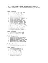
1980 - National Institute of Oceanography
1980 - National Institute of Oceanography
1980 - National Institute of Oceanography

Create successful ePaper yourself
Turn your PDF publications into a flip-book with our unique Google optimized e-Paper software.
covered during the cruise. In addition, 29 water samples, 46 grab samples, 4 dredge<br />
samples, 4 core samples and 12 bottom photographs were taken.<br />
The surveys indicated that the continental shelf from the shore to a depth <strong>of</strong><br />
60-75 m is marked by even topography because <strong>of</strong> the clay cover.<br />
Cruise 73 (Chief Scientist—H.N. Siddiquie)<br />
This cruise <strong>of</strong> 19-days duration was from 13 April to 1 May. It was sponsored<br />
by the ONGC for the development <strong>of</strong> <strong>of</strong>fshore oilfields. The work included: survey<br />
<strong>of</strong> the pipeline routes from South Bassein to Direction Bank, from Direction Bank up<br />
to the shore and shallow seismic surveys at South Bassein and Direction Bank.<br />
During this cruise, more than 290 line km <strong>of</strong> echosounding, 660 line km <strong>of</strong><br />
ORE mud penetrator pr<strong>of</strong>iling, 1060 line km <strong>of</strong> sparker and 120 line km <strong>of</strong> magnetic<br />
surveys were carried out.<br />
Along the proposed pipeline route (from Bassein to Direction Bank), the depth<br />
varied from 51 m at Bassein to 65 m on the southern side and 41 m at the Bank.<br />
From Direction Bank along the route the depth ranged from 45 m at the Bank to<br />
55 m towards east and 15 m near the shore.<br />
Cruise 74 (Chief Scientist—H.N. Siddiquie)<br />
This 12-days cruise from 4 to 15 May was carried out in continuation <strong>of</strong> the<br />
earlier cruise. During the cruise shallow seismic pr<strong>of</strong>iling on the Bassein structure and<br />
the post-lay survey <strong>of</strong> the pipelines from Bassein to Bombay High were carried out.<br />
In all, 20 lines were surveyed in the south Bassein and the pipeline pr<strong>of</strong>iling<br />
was done along 50 lines. Over 673 line km <strong>of</strong> echosounding. 200 line km <strong>of</strong> side<br />
scan sonar and 671 line km <strong>of</strong> shallow seismic pr<strong>of</strong>iling were carried out.<br />
The depth on south Bassein ranged from 38 to 69 m and increased, in the<br />
northern and eastern sides and also in the southern and western sides- The pipeline<br />
was crossed, in 64 tracks and the pipes were seen in 43 tracks. Along 52 tracks, the<br />
pipelines were very well covered by 2.2.5 m thick sediments and in the remaining 2<br />
tracks, the pipelines apparently were on the seabed or were covered by a thin sediment<br />
only.<br />
Cruise 75 (Chief Scientist—M.G.A.P. Setty)<br />
This 14-days cruise from 21 May to 3 June was devoted to the study <strong>of</strong> oceanographic<br />
conditions in the MONEX square ( between 11-15°N and 68-71° 31' E) during<br />
the onset <strong>of</strong> southwest monsoon. Another aspect <strong>of</strong> the cruise was to study primaryproductivity,<br />
nannoplankton and extra cellular liberation <strong>of</strong> photosynthates at<br />
various depths <strong>of</strong> the euphotic zone.<br />
The cruise covered a distance <strong>of</strong> 3892 line km. in which 50 stations were<br />
worked. Data on phosphate, nitrate, nitrite, ammonia and silicate were collected at<br />
all the stations.<br />
At the request <strong>of</strong> BARC, sediment samples from deeper parts <strong>of</strong> the sea were<br />
collected for their use- Radon activity was also studied during the cruise.<br />
14