Antelope Valley Solar by Renewable Resources ... - County of Kern
Antelope Valley Solar by Renewable Resources ... - County of Kern
Antelope Valley Solar by Renewable Resources ... - County of Kern

Create successful ePaper yourself
Turn your PDF publications into a flip-book with our unique Google optimized e-Paper software.
PLANNING DEPARTMENT<br />
TED JAMES, AICP, Director<br />
2700 "M" STREET, SUITE 100<br />
BAKERSFIELD, CA 93301-2323 Phone:<br />
(661) 862-8600<br />
FAX: (661) 862-8601 TTY Relay 1-800-735-2929<br />
E-Mail: planning@co.kern.ca.us<br />
Web Address: www.co.kern.ca.us/planning<br />
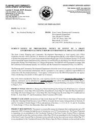
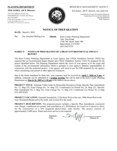
DATE: March 8, 2010<br />
NOTICE OF PREPARATION<br />
RESOURCE MANAGEMENT AGENCY<br />
To: See Attached Mailing List FROM: <strong>Kern</strong> <strong>County</strong> Planning Department<br />
Attn: Sara Kopp<br />
2700 "M" Street, Suite 100<br />
Bakersfield, CA 93301<br />
(661) 862-8793<br />
Ted James, AICP, Interim, RMA DIRECTOR<br />
Community & Economic Development Department<br />
Engineering & Survey Services Department<br />
Planning Department<br />
Roads Department<br />
SUBJECT: NOTICE OF PREPARATION OF A DRAFT ENVIRONMENTAL IMPACT<br />
REPORT<br />
The <strong>Kern</strong> <strong>County</strong> Planning Department as Lead Agency (per CEQA Guidelines Section 15052) has<br />
required that an Environmental Impact Report (per CEQA Guidelines Section 15161) be prepared for the<br />
project identified below. The Planning Department solicits the views <strong>of</strong> your agency as to the scope and<br />
content <strong>of</strong> the environmental information which is germane to your agency's statutory responsibilities in<br />
connection with the proposed project. Your agency will need to use the EIR prepared <strong>by</strong> our agency<br />
when considering your permit or other approval <strong>of</strong> projects.<br />
Due to the limits mandated <strong>by</strong> State law, your response must be received <strong>by</strong> April 7, 2010 at 5 pm. In<br />
addition, comments can be submitted at a scoping meeting that will be held at the <strong>Kern</strong> <strong>County</strong> Planning<br />
Department on March 26, 2009 at 1:30 pm at the address shown above.<br />
PROJECT TITLE: <strong>Antelope</strong> <strong>Valley</strong> <strong>Solar</strong> <strong>by</strong> <strong>Renewable</strong> <strong>Resources</strong> Group; Specific Plan Amendment<br />
No. 17, Map 232; Zone Change No. 34, Map 232; Conditional Use Permit No. 28, Map 232; Specific<br />
Plan Amendment No. 3, Map 233; Zone Change No. 13, Map 233; Conditional Use Permit No. 8, Map<br />
233; (PP10242)<br />
PROJECT LOCATION: Generally bounded <strong>by</strong> 115th Street West to the east, 190th Street West to the<br />
west, Rosamond Boulevard to the north, and Avenue B to the south.<br />
PROJECT DESCRIPTION: The proposed project includes a Specific Plan Amendment, concurrent<br />
zone change, conditional use permit, and cancellation <strong>of</strong> a Williamson Act Land Use Contract to allow<br />
for the construction <strong>of</strong> a 650 megawatt photovoltaic solar facility. The project consists <strong>of</strong><br />
approximately 5,400 acres. Water and sewer service is not required.<br />
Signature:<br />
Title:<br />
Planner II
Eirssk09-10.Nop Los Angeles <strong>County</strong><br />
Department <strong>of</strong> Regional Planning<br />
320 West Temple Street, Room 1390<br />
Los Angeles, CA 90012<br />
China Lake Naval Weapons Center<br />
Commanding Officer Code<br />
Environmental Managment (O'Gara)<br />
Mail Stop 4014<br />
China Lake, CA 93555-6108<br />
U.S. Fish & Wildlife Service<br />
Ashleigh Blackford<br />
2493 Portola Road, Suite B<br />
Ventura, CA 93003<br />
Edwards Air Force Base<br />
AFFTC/XRX Bldg 0001, Rm 110<br />
#1 South Rosamond Boulevard<br />
Edwards AFB, CA 93524-1936<br />
U.S. Department <strong>of</strong> Agriculture<br />
Natural <strong>Resources</strong> Conservation Service<br />
5000 California Avenue, Suite 100<br />
Bakersfield, CA 93309-0711<br />
Bureau <strong>of</strong> Land Management<br />
Caliente/Bakersfield<br />
3801 Pegasus Drive<br />
Bakersfield, CA 93308-6837<br />
U.S. Environmental Protection Agency<br />
Region IX Office / Attn: David Tomsovic<br />
75 Hawthorn Street /Mail CMD -2<br />
San Francisco, CA 94105<br />
<strong>Antelope</strong> <strong>Valley</strong> Resource<br />
Conservation Dist.<br />
44811 Date Avenue, #G<br />
Lancaster, CA 93534-3136<br />
<strong>Kern</strong> <strong>County</strong> Agriculture Department <strong>Kern</strong> <strong>County</strong> Airports <strong>Kern</strong> <strong>County</strong> Air Pollution Control District<br />
Community Development <strong>Kern</strong> <strong>County</strong> Administrative Officer <strong>Kern</strong> <strong>County</strong> Engineering & Survey Svs/<br />
Floodplain<br />
<strong>Kern</strong> <strong>County</strong> Engineering & Survey Svs/<br />
Survey<br />
<strong>Kern</strong> <strong>County</strong> Env Health Services Department <strong>Kern</strong> <strong>County</strong> Fire Department<br />
<strong>Kern</strong> <strong>County</strong> Library/Diane Duquette <strong>Kern</strong> <strong>County</strong> Parks and Recreation Resource Management Agency<br />
Special Projects/Fiscal Analysis<br />
<strong>Kern</strong> <strong>County</strong> Sheriff's Department<br />
Administration<br />
Southern <strong>Kern</strong> Unified School Dist.<br />
P.O. Box CC<br />
Rosamond, CA 93560<br />
Local Agency Formation Commission<br />
5300 Lennox Avenue, Suite 303<br />
Bakersfield, CA 93309<br />
<strong>Kern</strong> <strong>County</strong> Roads Department <strong>Kern</strong> <strong>County</strong> Waste Management Department<br />
<strong>Kern</strong> <strong>County</strong> Superintendent <strong>of</strong> Schools<br />
Attention Mary Baker<br />
1300 - 17th Street<br />
Bakersfield, CA 93301-4533<br />
<strong>Antelope</strong> <strong>Valley</strong>-East <strong>Kern</strong><br />
Water Agency<br />
6500 West Avenue N<br />
Palmdale, CA 93551<br />
<strong>Kern</strong>COG<br />
<strong>Kern</strong> <strong>County</strong> Water Agency<br />
P.O. Box 58<br />
Bakersfield, CA 93302-0058
Native American Heritage Council<br />
<strong>of</strong> <strong>Kern</strong> <strong>County</strong><br />
P.O. Box 1507<br />
Bakersfield, CA 93302<br />
California Farm Bureau Federation<br />
2300 River Plaza Drive, NRED<br />
Sacramento, CA 95833<br />
Caltrans/Dist. 9<br />
Planning Department<br />
500 South Main Street<br />
Bishop, CA 93514<br />
State Dept. <strong>of</strong> Conservation<br />
Division <strong>of</strong> Oil & Gas<br />
4800 Stockdale Highway, Ste 417<br />
Bakersfield, CA 93309<br />
California Food and Agriculture<br />
1220 "N" Street<br />
Sacramento, CA 95814<br />
Public Utilities Commission<br />
Energy Division<br />
505 Van Ness Avenue<br />
San Francisco, CA 94102<br />
Tejon Indian Tribe<br />
Kathy Morgan, Chairperson<br />
2234 4th Street<br />
Wasco, CA 93280<br />
Santa Rosa Rancheria<br />
Clarence Atwell, Chairperson<br />
P.O. Box 8<br />
Lemoore, CA 93245<br />
U.S. Air Force<br />
Western Regional Environmental Office<br />
50 Fremont Street, Suite 2450<br />
San Francisco, CA 94105-2230<br />
U.S. Navy<br />
Sheila Donovan<br />
1220 Pacific Highway<br />
San Diego, CA 92132<br />
Sierra Club/<strong>Kern</strong> Keaweah Chapter<br />
Arthur Unger<br />
****PUT IN BUCKET ***<br />
Stationary Resource Division<br />
(California Air <strong>Resources</strong> Board)<br />
Attention Barbara Fry<br />
P.O. Box 2815<br />
Sacramento, CA 95812<br />
State Mining and Geology Board<br />
801 "K" Street, MS 20-15<br />
Sacramento, CA 95814<br />
California Energy Commission<br />
1516 Ninth Street, Room 200<br />
Sacramento, CA 95814<br />
California Highway Patrol<br />
Planning and Analysis Division<br />
P.O. Box 942898<br />
Sacramento, CA 94298-0001<br />
California Regional Water Quality<br />
Control Board/Lahontan Region<br />
14440 Civic Drive, Suite 200<br />
Victorville, CA 92392-2306<br />
Kitanemuk & Yowlumne Tejon Indians<br />
Delia Dominguez<br />
981 North Virginia<br />
Covina, CA 91722<br />
Tule River Indian Tribe<br />
Neal Peyron, Chairperson<br />
P.O. Box 589<br />
Porterville, CA 93258<br />
U.S. Army<br />
Dir <strong>of</strong> Public Works/Master Plan Div<br />
P.O. Box 105097<br />
Fort Irwin, CA 92310-5097<br />
U.S. Marine Corps<br />
Patrick Christman<br />
Building 1164/Box 555246<br />
Camp Pendleton, CA 92055<br />
Smart Growth Coalition<br />
302 South Mojave Street<br />
Mojave, CA 93561<br />
Southern San Joaquin <strong>Valley</strong><br />
Archaeological Information Center<br />
California State University<br />
9001 Stockdale Highway<br />
Bakersfield, CA 93311<br />
State Clearinghouse<br />
Office <strong>of</strong> Planning and Research<br />
P.O. Box 3044<br />
Sacramento, CA 95812-3044 - CERTIFIED<br />
MAIL<br />
State Dept. <strong>of</strong> Fish & Game<br />
1234 East Shaw Avenue<br />
Fresno, CA 93710<br />
Integrated Waste Management<br />
Attention Sue O'Leary, MS #15<br />
P.O. Box 4025<br />
Sacramento, CA 95812-4025<br />
<strong>Kern</strong> <strong>Valley</strong> Tribal Council<br />
P.O. Box 168<br />
<strong>Kern</strong>ville, CA 93238<br />
Chumash Council <strong>of</strong> Bakersfield<br />
P.O. Box 902<br />
Bakersfield, CA 93302<br />
Tubatulabals <strong>of</strong> <strong>Kern</strong> <strong>County</strong><br />
P.O. Box 226<br />
Lake Isabella, CA 93240<br />
U.S. Army<br />
Peter Rubin<br />
B790 5th Street<br />
Parks RFTA<br />
Dublin, CA 94568<br />
Calif. Dept <strong>of</strong>Toxic Substances Control<br />
1001 "I" Street<br />
P.O. Box 806<br />
Sacramento, CA 95812-0806
Center on Race, Poverty, & the Environment<br />
Attention: Executive Director<br />
47 Kearny Street, Suite 804<br />
San Francisco, CA 94108-5528<br />
Defenders <strong>of</strong> Wildlife<br />
P.O. Box 953<br />
Joshua Tree, CA 92252<br />
Rosamond Municipal Advisory Council<br />
P.O. Box 626<br />
Rosamond, CA 93560<br />
Beth Boyst<br />
Pacific Crest Trail Program Manager<br />
1323 Club Drive<br />
Vallejo, CA 94592<br />
David Laughing Horse Robinson<br />
P.O. Box 1547<br />
<strong>Kern</strong>ville, CA 93238<br />
State Dept. <strong>of</strong> Conservation<br />
Director's Office<br />
801 "K" Street, MS 24-01<br />
Sacramento, CA 95814-3528<br />
City <strong>of</strong> Bakersfield<br />
Planning Department<br />
1715 Chester Avenue<br />
Bakersfield, CA 93301<br />
City <strong>of</strong> Maricopa<br />
P.O. Box 548<br />
Maricopa, CA 93252<br />
City <strong>of</strong> Shafter<br />
336 Pacific Avenue<br />
Shafter, CA 93263<br />
City <strong>of</strong> Wasco<br />
764 "E" Street<br />
Wasco, CA 93280-1930<br />
Center on Race, Poverty, & the Environment<br />
Attention Caroline Farrell<br />
1302 Jefferson Street, Suite 2<br />
Delano, CA 93215<br />
Eight Bar Ranch<br />
Jon and Helen Lantz<br />
11300 Cameron Canyon Road<br />
Mojave, CA 93501<br />
<strong>Kern</strong> <strong>County</strong> Library<br />
Wanda Kirk/Rosamond Branch<br />
3611 Rosamond Boulevard<br />
Rosamond, CA 93560<br />
Eric Mason<br />
Pacific Crest Trail Association<br />
P.O. Box 3398<br />
Idyllwild, CA 92549<br />
State Dept. <strong>of</strong> Public Health<br />
Drinking Water Field Operations Branch<br />
265 W Bullard Avenue, Suite 101<br />
Fresno, CA 93704-1755<br />
State Dept. <strong>of</strong> Conservation<br />
Office <strong>of</strong> Land Conservation<br />
801 "K" Street, MS 18-01<br />
Sacramento, CA 95814<br />
California City Planning<br />
21000 Hacienda Boulevard<br />
California City, CA 93515<br />
City <strong>of</strong> McFarland<br />
401 West <strong>Kern</strong> Avenue<br />
McFarland, CA 93250<br />
City <strong>of</strong> Taft<br />
Planning and Building<br />
209 East <strong>Kern</strong> Street<br />
Taft, CA 93268<br />
Inyo <strong>County</strong> Planning Department<br />
P.O. Drawer "L"<br />
Independence, CA 93526<br />
Cuddy <strong>Valley</strong> Statistical<br />
11667 Steinh<strong>of</strong>f Road<br />
Frazier Park, CA 93222<br />
Northcutt and Associates<br />
P.O. Box 2893<br />
Lake Isabella, CA 93240<br />
<strong>Kern</strong> <strong>County</strong> Fire Department/Brian Marshall<br />
Suzanne Wilson<br />
Pacific Crest Trail Association<br />
26121-A Hemstreet Place<br />
Idyllwild, CA 92549<br />
State Department <strong>of</strong> Health Services/Drinking<br />
Water<br />
Jesse Dhaliwal<br />
1200 Discovery Drive, Ste 100<br />
Bakersfield, CA 93309<br />
City <strong>of</strong> Arvin<br />
P.O. Box 548<br />
Arvin, CA 93203<br />
City <strong>of</strong> Delano<br />
P.O. Box 3010<br />
Delano, CA 93216<br />
City <strong>of</strong> Ridgecrest<br />
100 West California Avenue<br />
Ridgecrest, CA 93555<br />
City <strong>of</strong> Tehachapi<br />
115 South Robinson Street<br />
Tehachapi, CA 93561-1722<br />
Kings <strong>County</strong> Planning Agency<br />
Kings <strong>County</strong> Government Building #6<br />
1400 West Lacey Boulevard<br />
Hanford, CA 93230
Los Angeles <strong>County</strong><br />
Department <strong>of</strong> Regional Planning<br />
320 West Temple Street, Room 1390<br />
Los Angeles, CA 90012<br />
Santa Barbara <strong>County</strong><br />
Planning and Development<br />
123 East Anapamu Street<br />
Santa Barbara, CA 93101<br />
U.S. Department <strong>of</strong> Energy<br />
Office <strong>of</strong> NEPA<br />
Director Carol Borgstrom<br />
1000 Independence Avenue, SW<br />
Washington, D.C. 20585-0119<br />
San Diego Gas and Electric<br />
P.O. Box 129831<br />
San Diego, CA 92112-9831<br />
San Bernardino <strong>County</strong><br />
Office <strong>of</strong> Planning<br />
385 North Arrowhead Avenue, 1st Floor<br />
San Bernardino, CA 92415-0182<br />
Tulare <strong>County</strong><br />
Planning & Development Dept.<br />
Room 105-111<br />
<strong>County</strong> Civic Center<br />
Visalia, CA 93291-4503<br />
Office <strong>of</strong> Historical Preservation<br />
Susan Stratton<br />
P.O. Box 942896<br />
Sacramento, CA 942896<br />
California Department <strong>of</strong> Fish and Game<br />
Dave Hacker<br />
Region 4 <strong>Renewable</strong> Energy Projects<br />
3196 South Higuera Street, Suite A<br />
San Luis Obispo, CA 93401<br />
San Luis Obispo <strong>County</strong><br />
Planning and Building Department<br />
<strong>County</strong> Government Center<br />
San Luis Obispo, CA 93408<br />
Ventura <strong>County</strong> RMA Planning Div.<br />
Attention Kim Rodriquez, Director<br />
800 South Victoria Avenue, L1740<br />
Ventura, CA 93009-1740<br />
Southern California Edison<br />
Attn: Cathy Hart<br />
42060 10 th Street, West<br />
Lanchester, CA 93534<br />
Pacific Gas & Electric Co.<br />
Shaw Office/Land Projects<br />
650 "O" Street, First Floor<br />
Fresno, CA 93760-0001
Mail to: State Clearinghouse, P.O. Box 3044, Sacramento, CA 95812-3044 (916) 445-0613<br />
For Hand Delivery/Street Address: 1400 Tenth Street, Sacramento, CA 95814<br />
<br />
<strong>Antelope</strong><br />
<strong>Valley</strong> <strong>Solar</strong> <strong>by</strong> <strong>Renewable</strong> <strong>Resources</strong> Group<br />
Lead Agency: <strong>Kern</strong> <strong>County</strong> Planning Department Contact Person: Sara Kopp<br />
Mailing Address: 2700 "M" Street, Suite 100 Phone: 661-862-8793<br />
City: Bakersfield Zip: 93301 <strong>County</strong>: <strong>Kern</strong><br />
<strong>County</strong>: <strong>Kern</strong> and Los Angeles City/Nearest Community: Rosamond<br />
Cross Streets: 110th Street West and 190th Street West Zip Code: 93560<br />
Longitude/Latitude (degrees, minutes and seconds): 34 52 0.7 N / 118 20 31.3 W Total Acres: 5,400 <br />
Assessor's Parcel No.: See attached Section: See attached Twp.: Range: Base:<br />
Within 2 Miles: State Hwy #: Waterways: California Aqueduct<br />
Airports: Railways: Schools:<br />
<br />
CEQA: ✔ NOP Draft EIR NEPA: NOI Other: Joint Document<br />
Early Cons Supplement/Subsequent EIR EA Final Document<br />
Neg Dec (Prior SCH No.) Draft EIS Other:<br />
Mit Neg Dec Other: FONSI<br />
Appendix C<br />
<br />
General Plan Update Specific Plan ✔ Rezone Annexation<br />
✔ Specific Plan Amendment Master Plan Prezone Redevelopment<br />
General Plan Element Planned Unit Development ✔ Use Permit Coastal Permit<br />
Community Plan Site Plan Land Division (Subdivision, etc.) Other: Cancellation <strong>of</strong><br />
Williamson Act Land<br />
<br />
Use Contract<br />
Residential: Units Acres<br />
Office: Sq.ft. Acres Employees Transportation: Type<br />
Commercial: Sq.ft. Acres Employees Mining: Mineral<br />
Industrial: Sq.ft. Acres Employees ✔ Power: Type <strong>Solar</strong> MW 650<br />
Educational: Waste Treatment:Type MGD<br />
Recreational: Hazardous Waste:Type<br />
Water Facilities:Type MGD Other:<br />
<br />
✔ Aesthetic/Visual Fiscal Recreation/Parks Vegetation<br />
✔ Agricultural Land Flood Plain/Flooding Schools/Universities Water Quality<br />
✔ Air Quality Forest Land/Fire Hazard Septic Systems Water Supply/Groundwater<br />
✔ Archeological/Historical ✔ Geologic/Seismic Sewer Capacity Wetland/Riparian<br />
✔ Biological <strong>Resources</strong> Minerals Soil Erosion/Compaction/Grading Growth Inducement<br />
Coastal Zone ✔ Noise Solid Waste Land Use<br />
Drainage/Absorption Population/Housing Balance Toxic/Hazardous ✔ Cumulative Effects<br />
Economic/Jobs ✔ Public Services/Facilities ✔ Traffic/Circulation Other:<br />
<br />
Vacant and Agricultural Production/A FPS, E (1) RS MH FPS, E (2 1/2), E (2 1/2) RS FPS, E (2 1/2) RS MH FPS, E (5) RS FPS, C-2<br />
PD/3.1,<br />
3.2, 5.3, 5.3/4.4, 5.3/4.4/2.6, 5.3, 4.4, 2.85, 5.6, 5.6/2.6, 5.6/2.6/2.8, 5.6/2.8, 5.6/2.85, 5.7/2.85, 6.2, 7.1/4.4, 8.1, 8.1/2.6,<br />
8.1/2.85,<br />
8.5/2.85; Los Angeles <strong>County</strong>: A-2-5/N1<br />
(please use a separate page if necessary)<br />
A Specific Plan Amendment to the Willow Springs Specific Plan, Zone Change, Conditional Use Permit for 5,400 acres, and<br />
cancellation <strong>of</strong> Williamson Act Land Use Contracts for portions <strong>of</strong> the site to allow for construction <strong>of</strong> a 650 MW photovoltaic<br />
solar facility.<br />
Note: The State Clearinghouse will assign identification numbers for all new projects. If a SCH number already exists for a project (e.g. Notice <strong>of</strong> Preparation or<br />
previous draft document)please fill in.<br />
Revised 2008
Lead Agencies may recommend State Clearinghouse distribution <strong>by</strong> marking agencies below with and "X".<br />
If you have already sent your document to the agency please denote that with an "S".<br />
S<br />
Air <strong>Resources</strong> Board Office <strong>of</strong> Emergency Services<br />
Boating & Waterways, Department <strong>of</strong> Office <strong>of</strong> Historic Preservation<br />
California Highway Patrol Office <strong>of</strong> Public School Construction<br />
Caltrans District # Parks & Recreation, Department <strong>of</strong><br />
Caltrans Division <strong>of</strong> Aeronautics Pesticide Regulation, Department <strong>of</strong><br />
Caltrans Planning S Public Utilities Commission<br />
Central <strong>Valley</strong> Flood Protection Board S Regional WQCB # 6<br />
Coachella <strong>Valley</strong> Mtns. Conservancy <strong>Resources</strong> Agency<br />
Coastal Commission S.F. Bay Conservation & Development Comm.<br />
Colorado River Board San Gabriel & Lower L.A. Rivers & Mtns. Conservancy<br />
Conservation, Department <strong>of</strong> San Joaquin River Conservancy<br />
Corrections, Department <strong>of</strong> Santa Monica Mtns. Conservancy<br />
Delta Protection Commission State Lands Commission<br />
Education, Department <strong>of</strong> SWRCB: Clean Water Grants<br />
Energy Commission SWRCB: Water Quality<br />
Fish & Game Region # SWRCB: Water Rights<br />
Food & Agriculture, Department <strong>of</strong> Tahoe Regional Planning Agency<br />
Forestry and Fire Protection, Department <strong>of</strong> S Toxic Substances Control, Department <strong>of</strong><br />
General Services, Department <strong>of</strong><br />
Health Services, Department <strong>of</strong><br />
Water <strong>Resources</strong>, Department <strong>of</strong><br />
Housing & Community Development Other:<br />
Integrated Waste Management Board<br />
Native American Heritage Commission<br />
Other:<br />
S<br />
S 9<br />
S<br />
S<br />
S 4<br />
S<br />
S<br />
<br />
Starting Date March 8, 2010 Ending Date April 7, 2010<br />
<br />
Consulting Firm: Applicant:<br />
Address: Address:<br />
City/State/Zip: City/State/Zip:<br />
Contact: Phone:<br />
Phone:<br />
<br />
<br />
Authority cited: Section 21083, Public <strong>Resources</strong> Code. Reference: Section 21161, Public <strong>Resources</strong> Code.<br />
Revised 2008
Section, Township, and Range<br />
Sec. 14, 19, 20, 21, 22, 23, 27, 28, 30, 31, 34 <strong>of</strong> T9N, R14W and Sec. 23, 24, 25, 27, 36 <strong>of</strong> T9N, R15W SBB&M.<br />
<strong>Kern</strong> <strong>County</strong> APNs<br />
261-120-05 359-011-01 359-011-11 359-041-05 359-174-02 359-175-05<br />
261-120-06 359-011-02 359-011-12 359-041-07 359-174-03 359-240-04<br />
261-193-01 359-011-03 359-011-13 359-041-08 359-174-04 359-321-01<br />
261-196-02 359-011-04 359-011-14 359-041-15 359-174-05 359-321-02<br />
261-196-03 359-011-05 359-011-15 359-041-17 359-174-06 359-324-20<br />
261-196-04 359-011-06 359-011-16 359-041-18 359-174-07 359-324-21<br />
261-196-09 359-011-07 359-011-17 359-041-24 359-174-08 359-331-24<br />
261-196-10 359-011-08 359-011-18 359-041-25 359-174-09 359-331-25<br />
261-196-11 359-011-09 359-011-19 359-041-26 359-174-10 359-331-26<br />
359-041-01 359-011-10 359-011-20 359-041-27 359-174-11 359-331-27<br />
359-041-11 359-041-22 359-011-21 359-041-29 359-174-12<br />
359-041-12 359-041-23 359-011-22 359-041-30 359-175-01<br />
359-041-13 359-331-19 359-011-23 359-041-31 359-175-02<br />
359-041-20 359-331-22 359-011-24 359-041-32 359-175-03<br />
359-041-21 359-100-05 359-020-50 359-174-01 359-175-04<br />
Los Angeles <strong>County</strong> APNs<br />
3258-001-001 3258-001-030 3258-001-041<br />
3258-001-024 3258-001-031 3261-001-002<br />
3258-001-028 3258-001-038 3261-001-003<br />
3258-001-029 3258-001-040 3261-001-004
INITIAL STUDY/NOTICE OF PREPARATION<br />
<strong>Antelope</strong> <strong>Valley</strong> <strong>Solar</strong> <strong>by</strong><br />
<strong>Renewable</strong> <strong>Resources</strong> Group, Inc.<br />
SPA No. 17, ZCC No. 34, CUP No. 28, Map No. 232<br />
SPA No. 3, ZCC No. 13, CUP No. 8, Map No. 233<br />
Williamson Act Land Use Contract Cancellation<br />
LEAD AGENCY:<br />
<strong>Kern</strong> <strong>County</strong> Planning Department<br />
2700 M Street, Suite 100<br />
Bakersfield, CA 93301-2370<br />
Contact: Sara Kopp<br />
(661) 862-8793<br />
TECHNICAL ASSISTANCE BY:<br />
RGP PLANNING & DEVELOPMENT SERVICES<br />
8921 RESEARCH DRIVE<br />
IRVINE, CA 92618<br />
March 2010
1. Project Description<br />
KERN COUNTY PLANNING DEPARTMENT<br />
ANTELOPE VALLEY SOLAR BY RENEWABLE RESOURCES GROUP, INC.<br />
1.1 Location<br />
The <strong>Antelope</strong> <strong>Valley</strong> <strong>Solar</strong> project (proposed project) site is located within unincorporated <strong>Kern</strong> and<br />
Los Angeles Counties, approximately ten miles west <strong>of</strong> the unincorporated community <strong>of</strong> Rosamond<br />
within the jurisdiction <strong>of</strong> the Willow Springs Specific Plan in <strong>Kern</strong> <strong>County</strong> and the <strong>Antelope</strong> <strong>Valley</strong><br />
Areawide General Plan in Los Angeles <strong>County</strong>. State Route (SR) 14 is approximately 9 miles east <strong>of</strong> the<br />
project site and Interstate 5 (I-5) is approximately 22 miles west. The project site is comprised <strong>of</strong> several<br />
non-contiguous areas totaling approximately 5,400 acres and is generally bounded <strong>by</strong> 110 th Street West<br />
on the east, 190 th Street West on the west, Avenue B on the south, and Rosamond Boulevard on the north.<br />
The proposed project site is located within portions <strong>of</strong> Sections 14, 19, 20, 21, 22, 23, 27, 28, 30, 31, 34<br />
<strong>of</strong> T9N, R14W and Sections 23, 24, 25, 27, 36 <strong>of</strong> T9N, R15W San Bernardino Base and Meridian<br />
(SBB&M).<br />
Please refer to Tables 1-1 and 1-2 for a listing <strong>of</strong> APNs included within the proposed project site. The<br />
project proposes to utilize portions <strong>of</strong> the <strong>Antelope</strong> <strong>Valley</strong> Water Bank site.<br />
Table 1-1<br />
<strong>Kern</strong> <strong>County</strong> APNs<br />
261-120-05 359-011-02 359-011-13 359-041-15 359-174-06 359-324-21<br />
261-120-06 359-011-03 359-011-14 359-041-17 359-174-07 359-331-24<br />
261-193-01 359-011-04 359-011-15 359-041-18 359-174-08 359-331-25<br />
261-196-02 359-011-05 359-011-16 359-041-24 359-174-09 359-331-26<br />
261-196-03 359-011-06 359-011-17 359-041-25 359-174-10 359-331-27<br />
261-196-04 359-011-07 359-011-18 359-041-26 359-174-11<br />
261-196-09 359-011-08 359-011-19 359-041-27 359-174-12<br />
261-196-10 359-011-09 359-011-20 359-041-29 359-175-01<br />
261-196-11 359-011-10 359-011-21 359-041-30 359-175-02<br />
359-041-01 359-041-22 359-011-22 359-041-31 359-175-03<br />
359-041-11 359-041-23 359-011-23 359-041-32 359-175-04<br />
359-041-12 359-331-19 359-011-24 359-174-01 359-175-05<br />
359-041-13 359-331-22 359-020-50 359-174-02 359-240-04<br />
359-041-20 359-100-05 359-041-05 359-174-03 359-321-01<br />
359-041-21 359-011-11 359-041-07 359-174-04 359-321-02<br />
359-011-01 359-011-12 359-041-08 359-174-05 359-324-20<br />
IS/NOP 1 March 2010
KERN COUNTY PLANNING DEPARTMENT<br />
ANTELOPE VALLEY SOLAR BY RENEWABLE RESOURCES GROUP, INC.<br />
Table 1-2<br />
Los Angeles <strong>County</strong> APNs<br />
3258-001-001 3258-001-030 3258-001-041<br />
3258-001-024 3258-001-031 3261-001-002<br />
3258-001-028 3258-001-038 3261-001-003<br />
3258-001-029 3258-001-040 3261-001-004<br />
Approximately 18 percent <strong>of</strong> the project site, 990 acres (all within <strong>Kern</strong> <strong>County</strong>), is under active<br />
Williamson Act Land Use Contracts. Refer to Table 1-3 for a list <strong>of</strong> parcels under contract.<br />
Table 1-3<br />
Williamson Act Land Use Contracted Parcels<br />
261-196-02 261-196-04 359-041-15<br />
261-196-03 359-041-11 359-041-17<br />
359-041-12<br />
1.2 Environmental Setting<br />
The project site consists <strong>of</strong> undeveloped lands and areas used for farming and grazing. Three existing<br />
housing units are located on two project parcels. Portions <strong>of</strong> the site are currently designated as Prime<br />
Farmland and Farmland <strong>of</strong> Statewide Importance <strong>by</strong> the California Department <strong>of</strong> Conservation (CDC),<br />
Division <strong>of</strong> Land Resource Protection’s <strong>Kern</strong> <strong>County</strong> Important Farmland 2008 and Los Angeles <strong>County</strong><br />
Important Farmland 2008 maps.<br />
This site is at the western edge <strong>of</strong> the <strong>Antelope</strong> <strong>Valley</strong> on the south side <strong>of</strong> the Tehachapi Mountains at<br />
elevation 2,650 feet. This area is desert vegetation. Topography across the project area is relatively flat as<br />
this site is located on the bajada <strong>of</strong> the Tehachapi Mountains which is an overlapping <strong>of</strong> alluvial fans with<br />
southern trending slope towards SR 138. Overall, the project area drains from the Tehachapi Mountains<br />
down the alluvial fans toward the southeast, with elevations decreasing approximately 200 feet over a<br />
distance <strong>of</strong> nearly six miles from the northwest portion <strong>of</strong> the project site to the southeast. Soils found on<br />
the project site include Cajon loamy sand; Cajon loamy sand, loamy substratum; Greenfield sandy loam;<br />
Hanford coarse sandy loam; Hanford sandy loam; Hesperia fine sandy loam; Hesperia loamy fine sand;<br />
Hesperia fine sandy loam, loamy substratum; Hesperia loam; Rosamond loamy fine sand; Rosamond<br />
loamy fine sand, hummocky; Rosamond fine sandy loam; Rosamond loam; Rosamond loam, sandy loam<br />
substratum; Rosamond silty clay loam; and Sunrise sandy loam.<br />
Fire suppression and emergency medical services would be provided to the project site <strong>by</strong> the <strong>Kern</strong><br />
<strong>County</strong> Fire Department’s (KCFD) Station No. 15, located approximately nine miles east <strong>of</strong> the site in the<br />
community <strong>of</strong> Rosamond, and the Los Angeles <strong>County</strong> Fire Department’s (LACFD) Station No. 112,<br />
located approximately seven miles southeast <strong>of</strong> the site in the community <strong>of</strong> <strong>Antelope</strong> Acres. Police<br />
services would be provided to the project site <strong>by</strong> the <strong>Kern</strong> <strong>County</strong> Sheriff’s Office’s (KCSO) station in<br />
Rosamond and the Los Angeles <strong>County</strong> Sheriff’s Department (LACSD) station in Lancaster, located<br />
IS/NOP 2 March 2010
KERN COUNTY PLANNING DEPARTMENT<br />
ANTELOPE VALLEY SOLAR BY RENEWABLE RESOURCES GROUP, INC.<br />
16 miles southeast <strong>of</strong> the site. The nearest schools and parks to the project site are located in Rosamond.<br />
The project site is five miles northeast <strong>of</strong> the Arthur B. Ripley Desert Woodland State Park and four miles<br />
north <strong>of</strong> the <strong>Antelope</strong> <strong>Valley</strong> Poppy Preserve Park.<br />
According to the Willow Springs Specific Plan, the <strong>Kern</strong> <strong>County</strong> portion <strong>of</strong> the project site is designated<br />
as Map Codes 3.1 (Parks and Recreation), 3.2 (Educational Facilities), 3.3 (Other Facilities),<br />
3.3/2.8 (Other Facilities/Military Flight Operations), 3.3/2.6/2.8 (Other Facilities/Erosion Hazard/Military<br />
Flight Operations), 5.3 (Max. 10 Units per net acre), 5.3/4.4 (Max. 10 Units per net acre/Comprehensive<br />
Planning Area), 5.3/4.4/2.6 (Max. 10 Units per net acre/Comprehensive Planning Area/Erosion Hazard),<br />
5.3/4.4/2.85 (Max. 10 Units per net acre/Comprehensive Planning Area/Noise Management Area),<br />
5.5 (Max. 1 Unit per net acre), 5.6 (Min. 2.5 Gross Acres per unit), 5.6/2.6 (Min. 2.5 Gross Acres per<br />
unit/Erosion Hazard), 5.6/2.6/2.8 (Min. 2.5 Gross Acres per unit/Erosion Hazard/Military Flight<br />
Operations), 5.6/2.8 (Min. 2.5 Gross Acres per unit/Military Flight Operations), 5.6/2.85 (Min. 2.5 Gross<br />
Acres per unit/Noise Management Area), 5.7 (Min. 5 Gross Acres per unit), 5.7/2.85 (Min. 5 Gross Acres<br />
per unit/Noise Management Area), 6.2 (General Commercial), 7.1/4.4 (Light Industrial/Comprehensive<br />
Planning Area), 8.1 (Intensive Agriculture), 8.1/2.6 (Intensive Agriculture/Erosion Hazard),<br />
8.1/2.6/2.85 (Intensive Agriculture/Erosion Hazard/Noise Management Area), 8.1/2.8 (Intensive<br />
Agriculture/Military Flight Operations), 8.1/2.85 (Intensive Agriculture/Noise Management Area),<br />
8.5/2.85 (Resource Management/Noise Management Area). The Los Angeles <strong>County</strong> General Plan<br />
<strong>Antelope</strong> <strong>Valley</strong> Area Plan designates the Los Angeles <strong>County</strong> portion <strong>of</strong> the site as N1 Non-urban 1<br />
(0.5 du/ac).<br />
The <strong>Kern</strong> <strong>County</strong> portions <strong>of</strong> the proposed project have <strong>Kern</strong> <strong>County</strong> Zoning Ordinance classifications <strong>of</strong><br />
A FPS (Exclusive Agriculture Floodplain Secondary Combining), E (1) RS MH FPS (Estate Residential<br />
One Acre Min. Residential Suburban Combining, Mobile Home Combining, Floodplain Secondary<br />
Combining), E (2 1/2) (Estate Residential 2 1/2 Acre Min.), E (2 1/2) RS FPS (Estate Residential<br />
2-½ Acre Min. Residential Suburban Combining, Floodplain Secondary Combining), E (2 1/2) RS MH<br />
FPS (Estate Residential 2 1/2 Acre Min. Residential Suburban Combining, Mobile Home Combining,<br />
Floodplain Secondary Combining), E (5) RS (Estate Residential 5 Acre Min. Residential Suburban<br />
Combining), E (5) RS FPS (Estate Residential 5 Acre Min. Residential Suburban Combining Floodplain<br />
Secondary Combining), C-2 PD (General Commercial Precise Development Combining). The<br />
Los Angeles <strong>County</strong> portions <strong>of</strong> the proposed project have a zoning classification <strong>of</strong> A-2-5 (Heavy<br />
Agriculture, 5 acres minimum required area). Land uses surrounding the project site consist primarily <strong>of</strong><br />
undeveloped lands and agricultural and grazing areas, with scattered homes. Refer to Table 1-4.<br />
IS/NOP 3 March 2010
Direction<br />
from<br />
Project Site<br />
Project Site Vacant and<br />
Agriculture<br />
KERN COUNTY PLANNING DEPARTMENT<br />
ANTELOPE VALLEY SOLAR BY RENEWABLE RESOURCES GROUP, INC.<br />
Table 1-4<br />
Proposed Project Site and Surrounding Land Uses<br />
Existing<br />
Land Use Existing Land Use Designation Existing Zoning<br />
<strong>Kern</strong> <strong>County</strong><br />
3.1 (Parks and Recreation);<br />
3.2 (Educational Facilities);<br />
3.3 (Other Facilities);<br />
3.3/2.8 (Other Facilities/Military Flight Operations);<br />
3.3/2.6/2.8 (Other Facilities/Erosion Hazard/Military<br />
Flight Operations);<br />
5.3 (Max. 10 Units per net acre);<br />
5.3/4.4 (Max. 10 Units per net acre/Comprehensive<br />
Planning Area); 5.3/4.4/2.6 (Max. 10 Units per net<br />
acre/Comprehensive Planning Area/Erosion Hazard);<br />
5.3/4.4/2.85 (Max. 10 Units per net acre/Comprehensive<br />
Planning Area/Noise Management Area);<br />
5.5 (Max. 1 Unit per net acre);<br />
5.6 (Min. 2.5 Gross Acres per unit); 5.6/2.6 (Min. 2.5<br />
Gross Acres per unit/Erosion Hazard);<br />
5.6/2.6/2.8 (Min. 2.5 Gross Acres per unit/Erosion<br />
Hazard/Military Flight Operations);<br />
5.6/2.8 (Min. 2.5 Gross Acres per unit/Military Flight<br />
Operations),<br />
5.6/2.85 (Min. 2.5 Gross Acres per unit/Noise<br />
Management Area);<br />
5.7 (Min. 5 Gross Acres per unit);<br />
5.7/2.85 (Min. 5 Gross Acres per unit/Noise Management<br />
Area);<br />
6.2 (General Commercial);<br />
7.1/4.4 (Light Industrial/Comprehensive Planning Area);<br />
8.1 (Intensive Agriculture);<br />
8.1/2.6 (Intensive Agriculture/Erosion Hazard);<br />
8.1/2.6/2.85 (Intensive Agriculture/Erosion Hazard/Noise<br />
Management Area);<br />
8.1/2.8 (Intensive Agriculture/Military Flight Operations);<br />
8.1/2.85 (Intensive Agriculture/Noise Management Area);<br />
8.5/2.85 (Resource Management/Noise Management Area)<br />
Los Angeles <strong>County</strong><br />
N1 Non-urban 1 (0.5 du/ac)<br />
<strong>Kern</strong> <strong>County</strong><br />
A FPS (Exclusive Agriculture<br />
Floodplain Secondary<br />
Combining);<br />
E (1) RS MH FPS (Estate<br />
Residential One Acre Min.<br />
Residential Suburban<br />
Combining, Mobile Home<br />
Combining, Floodplain<br />
Secondary Combining);<br />
E (2 1/2) (Estate Residential 2 1/2<br />
Acre Min.);<br />
E (2 1/2) RS FPS (Estate<br />
Residential 2 1/2 Acre Min.<br />
Residential Suburban<br />
Combining, Floodplain<br />
Secondary Combining);<br />
E (2 1/2) RS MH FPS (Estate<br />
Residential 2 1/2 Acre Min.<br />
Residential Suburban<br />
Combining, Mobile Home<br />
Combining, Floodplain<br />
Secondary Combining);<br />
E (5) RS (Estate Residential 5<br />
Acre Min. Residential Suburban<br />
Combining);<br />
E (5) RS FPS (Estate Residential<br />
5 Acre Min. Residential<br />
Suburban Combining Floodplain<br />
Secondary Combining);<br />
C-2 PD (General Commercial<br />
Precise Development<br />
Combining)<br />
Los Angeles <strong>County</strong><br />
A-2-5 (Heavy Agriculture, 5 acre<br />
minimum area)<br />
IS/NOP 4 March 2010
Direction<br />
from<br />
Project Site<br />
North Vacant and<br />
Agriculture<br />
East Vacant and<br />
Agriculture<br />
South Vacant and<br />
Agriculture<br />
KERN COUNTY PLANNING DEPARTMENT<br />
ANTELOPE VALLEY SOLAR BY RENEWABLE RESOURCES GROUP, INC.<br />
Existing<br />
Land Use Existing Land Use Designation Existing Zoning<br />
<strong>Kern</strong> <strong>County</strong><br />
3.3 (Other Facilities);<br />
5.3/4.4 (Max 10 Units per Net Acre/Comprehensive<br />
Planning Area);<br />
5.6 (Min. 2.5 Gross Acres per unit);<br />
5.6/2.6 (Min. 2.5 Gross Acres Per Unit/Erosion Hazard);<br />
5.7 (Min. 5 Gross Acres per unit);<br />
5.75 (Min 10 Gross Acres per unit)<br />
Los Angeles <strong>County</strong><br />
Not applicable<br />
<strong>Kern</strong> <strong>County</strong><br />
3.3 (Other Facilities);<br />
5.3/4.4/2.8 (Max 10 Units per Net Acre/Comprehensive<br />
Planning Area/Military Flight Operations);<br />
5.5/4.4/2.8 (Max. 1 Dwelling Unit per<br />
acre/Comprehensive Planning Area/Military Flight<br />
Operations);<br />
5.6 (Min. 2.5 Gross Acres per unit);<br />
5.7 (Min. 5 Gross Acres per unit);<br />
5.75 (Min 10 Gross Acres per unit);<br />
6.2/2.8 (General Commercial/Military Flight Operations)<br />
Los Angeles <strong>County</strong><br />
N1 Non-urban 1 (0.5 du/ac)<br />
<strong>Kern</strong> <strong>County</strong><br />
Not applicable.<br />
Los Angeles <strong>County</strong><br />
N1 Non-urban 1 (0.5 du/ac)<br />
<strong>Kern</strong> <strong>County</strong><br />
A FPS (Exclusive Agriculture<br />
Floodplain Secondary<br />
Combining);<br />
E (2 1/2) RS FPS (Estate<br />
Residential 2.5 Acre Min.<br />
Residential Suburban Combining<br />
Floodplain Secondary<br />
Combining);<br />
E (5) RS (Estate Residential 5<br />
Acre Min. Residential Suburban<br />
Combining);<br />
E (5) RS FPS (Estate Residential<br />
5 Acre Min. Residential<br />
Suburban Combining Floodplain<br />
Secondary Combining)<br />
Los Angeles <strong>County</strong><br />
Not applicable<br />
<strong>Kern</strong> <strong>County</strong><br />
A FPS (Exclusive Agriculture<br />
Floodplain Secondary<br />
Combining);<br />
E (2 1/2) RS FPS (Estate<br />
Residential 2.5 Acre Min.<br />
Residential Suburban Combining<br />
Floodplain Secondary<br />
Combining);<br />
SP (Special Planning District)<br />
Los Angeles <strong>County</strong><br />
A-2-2 (Heavy Agriculture, 2 acre<br />
minimum area)<br />
<strong>Kern</strong> <strong>County</strong><br />
Not applicable.<br />
Los Angeles <strong>County</strong><br />
A-1-2 (Light Agriculture, 2 acre<br />
minimum area)<br />
A-2-5 (Heavy Agriculture, 5 acre<br />
minimum area)<br />
IS/NOP 5 March 2010
Direction<br />
from<br />
Project Site<br />
West Vacant and<br />
Agriculture<br />
KERN COUNTY PLANNING DEPARTMENT<br />
ANTELOPE VALLEY SOLAR BY RENEWABLE RESOURCES GROUP, INC.<br />
Existing<br />
Land Use Existing Land Use Designation Existing Zoning<br />
<strong>Kern</strong> <strong>County</strong><br />
5.6 (Min. 2.5 Gross Acres per unit);<br />
5.6/2.8 (Min 2.5 Gross Acres per unit/Military Flight<br />
Operations);<br />
5.7 (Min. 5 Gross Acres per unit);<br />
5.7/2.8 (Min. 5 Gross Acres per unit/Military Flight<br />
Operations);<br />
8.1/2.85 (Intensive Agriculture/Noise Management Area);<br />
8.5 (Resource Management);<br />
8.5/2.85 (Resource Management/Noise Management Area)<br />
Los Angeles <strong>County</strong><br />
N1 Non-urban 1 (0.5 du/ac)<br />
<strong>Kern</strong> <strong>County</strong><br />
A (Exclusive Agriculture);<br />
A FPS (Exclusive Agriculture<br />
Floodplain Secondary<br />
Combining);<br />
E (2 1/2) RS (Estate Residential<br />
2.5 Acre Min. Residential<br />
Suburban Combining);<br />
E (2 1/2) RS FPS (Estate<br />
Residential 2.5 Acre Min.<br />
Residential Suburban Combining<br />
Floodplain Secondary<br />
Combining);<br />
E (5) RS (Estate Residential 5<br />
Acre Min. Residential Suburban<br />
Combining)<br />
E (5) RS FPS (Estate Residential<br />
5 Acre Min. Residential<br />
Suburban Combining Floodplain<br />
Secondary Combining)<br />
Los Angeles <strong>County</strong><br />
A-1-2 (Light Agriculture, 2 acre<br />
minimum)<br />
1.3 Proposed Project<br />
The applicant is proposing: (1) Specific Plan Amendment from 5.3/4.4, 5.3/4.4/2.6, 5.3/4.4/2.85, and<br />
7.1/4.4 to 5.3, 5.3/2.6, 5.3/2.85, and 7.1 or more restrictive designation; (2) an amendment to the<br />
Circulation Element <strong>of</strong> the Willow Springs Specific Plan to remove section and midsection line road<br />
reservations internal to the project site; (3) Zone Change from E (1) RS MH FPS, E (2 1/2), E (2 1/2)<br />
RS FPS, E (2 1/2) RS MH FPS, E (5) RS, E (5) RS FPS, and C-2 PD to A or more restrictive zone<br />
district; (4) Cancel Williamson Act Land Use Contracts; and (5) Conditional Use Permit (CUP) to allow a<br />
solar electrical generating facility in the A zone. The proposed project would develop a 650-megawatt<br />
(MW) solar photovoltaic (PV) power generating facility and associated infrastructure on a total <strong>of</strong><br />
approximately 5,400 acres <strong>of</strong> land within unincorporated <strong>Kern</strong> and Los Angeles Counties. The maximum<br />
net amount <strong>of</strong> land covered <strong>by</strong> PV panels and other project facilities would be approximately 2,000 to<br />
2,500 acres. The power produced <strong>by</strong> the proposed project would be conveyed to the local power grid via<br />
approximately five miles <strong>of</strong> a 230 kilovolt (kV) generation tie power line. The generation-tie line would<br />
be located within designated easement areas in the privately owned parcels, and would connect to the new<br />
Southern California Edison (SCE) Whirlwind substation on 170th Street West just south <strong>of</strong> Rosamond<br />
Boulevard.<br />
IS/NOP 6 March 2010
KERN COUNTY PLANNING DEPARTMENT<br />
ANTELOPE VALLEY SOLAR BY RENEWABLE RESOURCES GROUP, INC.<br />
The proposed project is intended to operate year-round, and could produce up to 650 MW <strong>of</strong> solar power<br />
annually at full build-out. The proposed project would generate electricity during daylight hours when<br />
electricity demand is at its peak, and would provide for the annual electricity needs <strong>of</strong> approximately<br />
230,000 residences under optimal conditions. The proposed project would consist <strong>of</strong> the following project<br />
components, which are described in detail below:<br />
(1) A solar field <strong>of</strong> 2,600-2,900 solar PV trackers.<br />
(2) Five miles <strong>of</strong> 230 kV transmission lines and towers, 85-100 feet tall, located between substations<br />
and switchyard.<br />
(3) A system <strong>of</strong> interior collection power lines, 35-60 feet tall, located between inverters and<br />
substation.<br />
(4) Two switchgear pads (100,000 square feet combined).<br />
(5) Two substations (27,000 square feet each).<br />
(6) 650 equipment pads (one per MW; each 675 square feet, 15 feet tall).<br />
(7) Two Operations and Maintenance (O&M) buildings (22,500 square feet each, 16 feet tall).<br />
(8) One above-ground water tank (48 feet wide <strong>by</strong> 20 feet tall).<br />
(9) Infrastructure including driveways and fencing (six-foot-tall chain link or ranch-style fencing<br />
topped with two feet <strong>of</strong> barbed wire).<br />
1.4 Project Facilities and Operations<br />
Project Facilities<br />
The project would utilize 2,600-2,900 PV trackers mounted with crystalline silicon panels. All panels<br />
would be oriented in the same direction as they track the sun’s movement from east to west. By design,<br />
the PV panels absorb sunlight to maximize electrical output and use anti-reflective glass, resulting in<br />
about half the reflectance <strong>of</strong> standard residential and commercial glass. Due to the limited rotation angles,<br />
the solar tracker panels have no potential for reflecting the sun’s rays upon any ground-plane position.<br />
The tracker would be configured as an array <strong>of</strong> north-south oriented rows <strong>of</strong> PV panels that rotate from<br />
east to west to follow the daily motion <strong>of</strong> the sun. These trackers can lay flat, horizontal to the ground, or<br />
can be tilted towards the south to enable additional capture <strong>of</strong> sunlight. A small motor (0.5 horsepower) is<br />
typically mounted in the center <strong>of</strong> a tracker array. The metal structural elements are constructed <strong>of</strong><br />
corrosion-resistant galvanized steel. Underground cabling would be used to transport electricity from the<br />
PV panels to the point <strong>of</strong> aggregation for the system.<br />
Individual PV panels are connected together in series to create a “string” to carry direct current (DC)<br />
electricity. Multiple DC strings are brought together into a combiner box to merge the strings into a single<br />
cable and provide overcurrent protection. From the combiner boxes, the cabling would run underground<br />
to inverters mounted on small concrete equipment pads distributed across the site. The inverters take the<br />
DC output from the combiner boxes and convert it to alternating current (AC) electricity.<br />
The AC electricity would then be increased to medium voltage with a standard “step-up” transformer. The<br />
medium voltage cabling would create a collection circuit that would carry the electricity to the proposed<br />
IS/NOP 7 March 2010
project substation via wires mounted on poles (35-60 feet tall).<br />
KERN COUNTY PLANNING DEPARTMENT<br />
ANTELOPE VALLEY SOLAR BY RENEWABLE RESOURCES GROUP, INC.<br />
The two project substations (each about 27,000 square feet) and their accompanying switchgear pads<br />
(about 100,000 square feet combined) would collect all the medium voltage circuits and would contain<br />
metering equipment, switchgear, protective relays, and larger transformers to step-up the voltage to match<br />
the voltage <strong>of</strong> the transmission grid at the interconnection point. The interconnection point would be the<br />
Whirlwind Substation, previously approved <strong>by</strong> the California Public Utilities Commission (CPUC) and<br />
owned <strong>by</strong> Southern California Edison (SCE). The project substations and the interconnection point would<br />
be linked <strong>by</strong> a generation-tie line hung on wood or steel poles (85-100 feet tall).<br />
Two O&M buildings (each approximately 22,500 square feet and 16 feet tall) would provide temporary<br />
assembly and storage space during construction. The buildings would include bathroom facilities serviced<br />
<strong>by</strong> a private septic system. A covered outdoor assembly and storage area (80,000 square feet, 16 feet tall)<br />
would be directly adjacent to the O&M buildings.<br />
Interconnection with Statewide Grid<br />
Power produced <strong>by</strong> the project would be conveyed to the electricity grid via a new 230 kV generation-tie<br />
line from the project facilities to SCE’s approved new Whirlwind Substation along the western side <strong>of</strong> the<br />
project site, west <strong>of</strong> 170 th Street West The project has secured two interconnection queue positions<br />
sufficient for the size <strong>of</strong> the project at the Whirlwind substation and has made the necessary reservation<br />
deposits to the California Independent System Operator (CAISO).<br />
The Whirlwind Substation is a component <strong>of</strong> SCE’s Tehachapi <strong>Renewable</strong> Transmission Project (TRTP),<br />
which is the first major transmission project in California being constructed specifically to access multiple<br />
renewable generators in a remote renewable-rich resource area. TRTP Segments 4-11 would include new<br />
and upgraded electric transmission lines and substations between <strong>Kern</strong> <strong>County</strong> and San Bernardino<br />
<strong>County</strong>. The CPUC approved TRTP Segments 4-11, issued its Notice <strong>of</strong> Determination on December 21,<br />
2009 (State Clearinghouse #2007081156), and construction is now underway.<br />
Construction Activities<br />
Approximately 650 daily workers would be present on-site during construction over a three-year period.<br />
Workers would gain access to the site using existing county and farm roads.<br />
Temporary facilities for use during construction <strong>of</strong> the facility include:<br />
(1) Two covered assembly areas (80,000 square feet each, 16 feet tall) for tracker panel assembly.<br />
(2) Concrete batch plant for pouring equipment pads.<br />
While most <strong>of</strong> the site has nearly level to gently sloping topography, some <strong>of</strong> the parcels where facilities<br />
and tracker arrays are located would require light grubbing and minimal or no grading for leveling and<br />
trenching. After site preparation, construction <strong>of</strong> staging areas and related facilities (water treatment,<br />
water storage and assembly areas) would occur. On-site assembly <strong>of</strong> trackers would take place in the<br />
assembly area. Construction <strong>of</strong> the tracker panel arrays would be done in repetitive stages throughout the<br />
site. The construction activities would overlap one another, with grading and access road construction<br />
preceding the installation <strong>of</strong> tracker panels and associated equipment within each array area.<br />
IS/NOP 8 March 2010
KERN COUNTY PLANNING DEPARTMENT<br />
ANTELOPE VALLEY SOLAR BY RENEWABLE RESOURCES GROUP, INC.<br />
As the tracker arrays are being assembled, construction <strong>of</strong> the substation, transmission line, switchyard,<br />
and O&M buildings would occur simultaneously. After the common facilities are completed in the earlier<br />
stages the workforce would be devoted more to array construction in the later stages.<br />
Initial construction <strong>of</strong> project components on the <strong>Antelope</strong> <strong>Valley</strong> Water Bank portion <strong>of</strong> the project site<br />
would differ slightly in that concrete foundations would elevate the facilities to accommodate water bank<br />
operations. The equipment pad and motors would also be raised two to three feet <strong>of</strong>f the ground using<br />
earthwork or <strong>by</strong> a driven pier.<br />
Project Operation and Maintenance<br />
After the construction phase, the O&M buildings would serve as the project’s facilities for approximately<br />
15 permanent full-time employees, which would include a plant manager, engineers, technicians, and<br />
security staff. The project facilities would be monitored during operating (daylight) hours, even though<br />
the project facilities would be capable <strong>of</strong> automatic start up, shutdown, self-diagnosis, and fault detection.<br />
The panels may be cleaned up to two times per year, if necessary to optimize output. Each cleaning would<br />
require a total <strong>of</strong> 15 to 20 acre-feet <strong>of</strong> water. The project would contract with the <strong>Antelope</strong> <strong>Valley</strong> Water<br />
Bank for water services and supply during operation. Project fencing would consist <strong>of</strong> either standard<br />
chain-link fencing (six feet tall) topped with barbed wire (two feet tall), or ranch-style fencing topped <strong>by</strong><br />
barbed wire, depending on agency requirements. Fencing would be placed along the perimeter <strong>of</strong> the<br />
project site to ensure safety <strong>of</strong> the public and security <strong>of</strong> the facility.<br />
1.5 Project Objectives<br />
Based upon these statewide goals and needs, the objectives for the proposed project are as follows:<br />
• Assist in achieving the State's <strong>Renewable</strong> Portfolio Standard and greenhouse gas (GHG)<br />
reduction objectives to the maximum extent possible based on anticipated transmission facility<br />
capacity and reserved queue position.<br />
• Locate solar power plant facilities as near as possible to electrical transmission facilities with<br />
anticipated capacity and reserved queue position.<br />
• Site the project in an area with excellent solar energy resource, in order to maximize productivity<br />
from the photovoltaic panels.<br />
• To the extent feasible, site the project on disturbed land.<br />
• Use a proven and available solar photovoltaic technology.<br />
• Ensure that the project can be constructed, and power provided at a competitive price.<br />
• Co-locate solar power plant facilities with underground water bank facilities in order to maximize<br />
use <strong>of</strong> water bank land and minimize the cost <strong>of</strong> providing solar renewable energy.<br />
1.6 Proposed Discretionary Actions/Required Approvals<br />
Construction and operation <strong>of</strong> the proposed project may require the following discretionary actions and<br />
approvals:<br />
<strong>Kern</strong> <strong>County</strong><br />
• Consideration and Certification <strong>of</strong> a Final Environmental Impact Report with appropriate<br />
Findings and Mitigation Measure Monitoring Program, if applicable, <strong>by</strong> the <strong>Kern</strong> <strong>County</strong> Board<br />
<strong>of</strong> Supervisors<br />
IS/NOP 9 March 2010
KERN COUNTY PLANNING DEPARTMENT<br />
ANTELOPE VALLEY SOLAR BY RENEWABLE RESOURCES GROUP, INC.<br />
• Specific Plan Amendment<br />
• <strong>Kern</strong> <strong>County</strong> zoning change<br />
• Williamson Act land use contract cancellation<br />
• CUP<br />
• Lot Line Adjustment, Parcel Merger, or Reversion to Acreage to combine parcels<br />
• Grading Permit<br />
• Building Permit<br />
• Drainage Plan<br />
Other Responsible Agencies<br />
• State Water <strong>Resources</strong> Control Board – National Pollutant Discharge Elimination System<br />
(NPDES)<br />
• <strong>Kern</strong> <strong>County</strong> Air Pollution Control District (KCAPCD)<br />
• California Department <strong>of</strong> Fish and Game (CDFG)<br />
• U.S. Fish and Wildlife Service (USFWS)<br />
Other additional permits from responsible agencies may be required for the proposed project.<br />
IS/NOP 10 March 2010
Source: ESRI; ESA, 2010.<br />
IS/NOP<br />
5<br />
0 6<br />
Miles<br />
<strong>Kern</strong> <strong>County</strong><br />
Area <strong>of</strong> Detail<br />
<strong>Kern</strong> <strong>County</strong><br />
Los Angeles <strong>County</strong><br />
Ripley State Park<br />
ANGELES NATIONAL FOREST<br />
138<br />
Pacific Crest Trail<br />
Avenue D<br />
11<br />
KERN COUNTY PLANNING DEPARTMENT<br />
ANTELOPE VALLEY SOLAR BY RENEWABLE RESOURCES GROUP, INC.<br />
SPA 17, ZCC 34, CUP 28, Map 232<br />
SPA 3, ZCC 13, CUP 8, Map 233<br />
Willow Springs Rd<br />
90th St West<br />
MOJAVE<br />
Project Location<br />
14<br />
California Poppy Reserve<br />
ROSAMOND<br />
Rosamond Blvd<br />
LANCASTER<br />
PALMDALE<br />
CALIFORNIA CITY<br />
58<br />
Figure 1: SITE VICINITY MAP<br />
March 2010
Legend 0 1<br />
Project Location<br />
Source: ESRI; ESA, 2010.<br />
IS/NOP<br />
180TH ST WEST<br />
<strong>Kern</strong> <strong>County</strong><br />
Los Angeles <strong>County</strong><br />
170TH ST WEST<br />
160TH ST WEST<br />
12<br />
KERN COUNTY PLANNING DEPARTMENT<br />
ANTELOPE VALLEY SOLAR BY RENEWABLE RESOURCES GROUP, INC.<br />
SPA 17, ZCC 34, CUP 28, Map 232<br />
SPA 3, ZCC 13, CUP 8, Map 233<br />
GASKELL RD<br />
KINGBIRD AVE<br />
AVE A<br />
ROSAMOND BLVD<br />
HOLIDAY AVE<br />
130TH ST WEST<br />
Figure 2: PROJECT SITE BOUNDARY AND ACCESS MAP<br />
120TH ST WEST<br />
Mile<br />
March 2010
A<br />
A GH<br />
A<br />
A<br />
E(5) RS<br />
A<br />
E(10) RS<br />
A<br />
E(2 1/2) RS FPS<br />
Legend<br />
A<br />
A - Exclusive Agriculture<br />
C-2 - General Commercial<br />
E(5) RS<br />
E(5) RS FPS<br />
E(1) - Estate 1 Acre<br />
E(2 1/2) - Estate 2.5 Acres<br />
E(5) - Estate 5 Acres<br />
E(10) - Estate 10 Acres<br />
E(20) A-1 - Estate 20 Acres<br />
OS - Open Space<br />
E(2 1/2) RS<br />
E(2 1/2)<br />
RS FPS<br />
SP - Special Planning<br />
A-1<br />
A-2<br />
FPS - Floodplain Secondary Combining<br />
A-2<br />
RS - Residential Suburban Combining<br />
PD - Precise Develpment Combining<br />
MH - Mobilehome Combining<br />
A-1<br />
A-1<br />
GH - Geologic Hazard<br />
A-1<br />
A-1 - Light Agriculture<br />
A-2 - Heavy Agriculture<br />
A-2<br />
A-1<br />
Source: ESRI; ESA, 2010.<br />
IS/NOP<br />
PL RS<br />
E(5) RS<br />
E(10) RS<br />
PL RS<br />
E(2 1/2) RS<br />
E(5)<br />
RS<br />
FPS<br />
E(5) RS<br />
E(5) RS<br />
E(2 1/2) RS<br />
E(5) RS<br />
A<br />
A FPS<br />
E(2 1/2)<br />
RS FPS<br />
A FPS<br />
170TH ST WEST<br />
OS<br />
E(2 1/2) RS FPS<br />
E(5) RS FPS<br />
HOLIDAY AVE<br />
A FPS<br />
160TH ST WEST<br />
E(20) RS FPS<br />
E(5) RS FPS<br />
E(5) RS FPS<br />
KINGBIRD AVE<br />
13<br />
A-2<br />
KERN COUNTY PLANNING DEPARTMENT<br />
ANTELOPE VALLEY SOLAR BY RENEWABLE RESOURCES GROUP, INC.<br />
SPA 17, ZCC 34, CUP 28, Map 232<br />
SPA 3, ZCC 13, CUP 8, Map 233<br />
A FPS<br />
E(5)<br />
RS<br />
FPS<br />
E(5)<br />
RS<br />
FPS<br />
E(5) RS MH FPS<br />
AVE A<br />
ROSAMOND BLVD<br />
A FPS<br />
A FPS<br />
A-2-5<br />
A-2-5 A-2<br />
A-2<br />
A-2<br />
A FPS<br />
E(5) RS FPS<br />
GASKELL RD<br />
A FPS<br />
E(2 1/2) RS FPS<br />
E(2 1/2)<br />
RS FPS<br />
E(2 1/2) RS FPS<br />
E(2 1/2) RS FPS<br />
130TH ST WEST<br />
E(2 1/2)<br />
RS<br />
MH<br />
FPS<br />
E(5) RS FPS<br />
E(2 1/2)<br />
RS<br />
FPS<br />
E(1) RS MH FPS<br />
C-2 PD<br />
E(2 1/2) RS<br />
MH FPS<br />
E(2 1/2)<br />
RS FPS<br />
120TH ST WEST<br />
E(5) RS FPS<br />
E(2 1/2) RS FPS<br />
E(2 1/2)<br />
RS FPS<br />
E(2 1/2) RS<br />
MH FPS<br />
SP<br />
A FPS<br />
E(2 1/2) RS FPS<br />
A FPS*<br />
A FPS<br />
A-2 0 A-2-5 A-1-2 A-2-2 1<br />
Mile<br />
Figure 3: EXISTING ZONING MAP<br />
March 2010
180TH ST WEST<br />
Legend<br />
Proposed Rezoning Area<br />
Source: ESRI; ESA, 2010.<br />
IS/NOP<br />
<strong>Kern</strong> <strong>County</strong><br />
Los Angeles <strong>County</strong><br />
170TH ST WEST<br />
ROSAMOND BLVD<br />
160TH ST WEST<br />
14<br />
KERN COUNTY PLANNING DEPARTMENT<br />
ANTELOPE VALLEY SOLAR BY RENEWABLE RESOURCES GROUP, INC.<br />
SPA 17, ZCC 34, CUP 28, Map 232<br />
SPA 3, ZCC 13, CUP 8, Map 233<br />
GASKELL RD<br />
KINGBIRD AVE<br />
AVE A<br />
HOLIDAY AVE<br />
130TH ST WEST<br />
120TH ST WEST<br />
0 1<br />
Figure 4: AREA PROPOSED FOR REZONING WITHIN THE PROJECT SITE BOUNDARY<br />
Mile<br />
March 2010
8.5<br />
8.5/2.4<br />
8.5/2.1<br />
5.75 5.7<br />
8.5/2.85<br />
5.75<br />
5.7<br />
8.5/2.85<br />
Legend<br />
8.1/2.85 8.1/2.85<br />
8.1/2.6/2.85<br />
8.1/2.85 8.1/2.85<br />
2.1 - Seismic Hazard<br />
2.4 - Steep Slope<br />
8.1/2.6/2.85<br />
GASKELL RD<br />
2.6 - Erosion Hazard<br />
8.1/2.8<br />
2.8 - Military Flight Operations (60db) 5.7/2.8<br />
8.1/2.8<br />
2.85 - Military Flight Operations (65db)<br />
8.5/2.6/2.8<br />
3.1 - Public or Private Recreation Area<br />
3.2 - Educational Facilities<br />
3.3/2.8<br />
8.1<br />
8.5/2.8<br />
3.3 - Other Facilities<br />
4.4 - Comprehensive Plan<br />
5.3 - Maximum 10 Units / Net Acre<br />
5.5 - Maximum 1 Unit<br />
5.6 - Minimum 2.5 Gross Acres / Unit<br />
5.7 - Minimum 5 Gross Acres / Unit<br />
5.6/2.8<br />
3.3<br />
8.1<br />
6.2 - General Commercial<br />
6.2 - General Commercial<br />
7.1 - Light Industrial<br />
7.2 - Service Industrial<br />
8.1 - Intensive Agriculture (Min. 20 Acre Parcel Size)<br />
8.5 - Resource Management (Min. 20 Acre Parcel Size)<br />
N1 - Non-Urban 1 (0.5 du/ac)<br />
N1<br />
Source: ESRI; ESA, 2010.<br />
IS/NOP<br />
8.5/2.4<br />
180TH ST WEST<br />
3.3<br />
5.6<br />
5.6<br />
6.2<br />
5.5<br />
5.6<br />
8.1/2.85<br />
3.2<br />
3.1<br />
8.1/2.85<br />
5.6/2.6<br />
8.1<br />
2.6<br />
2.85<br />
8.1/2.85<br />
8.1/2.85<br />
5.8<br />
ROSAMOND BLVD<br />
6.2<br />
160TH ST WEST<br />
8.5/2.85<br />
7.1/4.4<br />
8.1<br />
8.1/2.85<br />
KINGBIRD AVE<br />
15<br />
KERN COUNTY PLANNING DEPARTMENT<br />
ANTELOPE VALLEY SOLAR BY RENEWABLE RESOURCES GROUP, INC.<br />
SPA 17, ZCC 34, CUP 28, Map 232<br />
SPA 3, ZCC 13, CUP 8, Map 233<br />
5.7<br />
5.3/4.4/2.85<br />
7.1/4.4<br />
N1<br />
5.7<br />
6.2 5.3/4.4/2.85<br />
5.7/2.6/2.85<br />
6.2<br />
5.6/2.85<br />
6.2 6.2/2.6<br />
7.1/4.4/2.6<br />
5.6/2.6<br />
5.75<br />
8.1/2.6<br />
5.3/4.4/2.6<br />
5.3/4.4/2.6<br />
5.3/4.4/2.6<br />
AVE A<br />
HOLIDAY AVE<br />
8.1/2.6/2.85<br />
5.6/2.6/2.8<br />
7.1/4.4<br />
5.7/2.85<br />
N1<br />
8.1/2.85<br />
5.3/4.4<br />
6.2<br />
130TH ST WEST<br />
6.2<br />
6.2<br />
8.5<br />
5.6<br />
3.2<br />
3.1<br />
5.6/2.6/2.8<br />
5.3/4.4/2.6<br />
5.6/2.85<br />
5.6/2.8<br />
6.2<br />
5.6<br />
6.2<br />
5.3<br />
5.7<br />
5.6/2.6<br />
120TH ST WEST<br />
6.2/2.8<br />
5.6<br />
5.6<br />
8.5<br />
5.3/4.4/2.8<br />
5.3/4.4/2.8<br />
5.3/4.4/2.<br />
3.3/2.8<br />
8.5/2.85<br />
5.5/4.4/2.8<br />
5.5/4.4/2.8<br />
0 1<br />
Figure 5: GENERAL PLAN LAND USE DESIGNATIONS MAP<br />
Mile<br />
March 2010
322.3ac<br />
Legend<br />
Project Parcels<br />
Source: ESRI; ESA, 2010.<br />
IS/NOP<br />
180TH ST WEST<br />
20.3ac<br />
20.7ac<br />
<strong>Kern</strong> <strong>County</strong><br />
Los Angeles <strong>County</strong><br />
170TH ST WEST<br />
157.8ac<br />
323ac<br />
197.1ac<br />
118.1ac<br />
ROSAMOND BLVD<br />
161ac<br />
155ac<br />
160TH ST WEST<br />
39.7<br />
ac<br />
9.8<br />
ac<br />
40.2<br />
ac<br />
9.9<br />
ac 9.8<br />
ac<br />
9.8<br />
ac 9.8<br />
ac<br />
10ac<br />
9.7<br />
ac<br />
79.4<br />
ac<br />
156.6ac<br />
154.7ac<br />
71.2<br />
ac<br />
10.2<br />
ac<br />
67.2<br />
ac<br />
10ac<br />
10.1ac<br />
162.4ac<br />
160.9ac<br />
39.6<br />
ac<br />
38.8<br />
ac<br />
39.8<br />
ac<br />
38.8<br />
ac<br />
81.3ac<br />
78.8<br />
ac<br />
16<br />
39.9<br />
ac<br />
KERN COUNTY PLANNING DEPARTMENT<br />
ANTELOPE VALLEY SOLAR BY RENEWABLE RESOURCES GROUP, INC.<br />
SPA 17, ZCC 34, CUP 28, Map 232<br />
SPA 3, ZCC 13, CUP 8, Map 233<br />
GASKELL RD<br />
KINGBIRD AVE<br />
157.4ac<br />
AVE A<br />
466.3ac<br />
79.8<br />
ac<br />
HOLIDAY AVE<br />
19.7<br />
ac<br />
19.9<br />
ac<br />
71.8<br />
ac<br />
20<br />
ac<br />
20.1<br />
ac<br />
79.4<br />
ac<br />
20.1<br />
ac<br />
160.6ac<br />
20.1<br />
ac<br />
157<br />
ac<br />
20.2<br />
ac<br />
130TH ST WEST<br />
160.7ac<br />
20<br />
ac<br />
20<br />
ac<br />
19.9<br />
ac<br />
19.9<br />
ac<br />
18.9<br />
ac<br />
19.4<br />
ac<br />
19.1<br />
ac<br />
20.1<br />
ac<br />
19.8<br />
ac<br />
20.3<br />
ac<br />
19.9<br />
ac<br />
19.2<br />
ac<br />
20.119.3<br />
ac ac<br />
19.2<br />
ac<br />
20<br />
ac<br />
78.6<br />
ac<br />
18.7<br />
ac<br />
82.1<br />
ac<br />
19.8<br />
ac<br />
20.3<br />
ac<br />
20<br />
ac<br />
20.1<br />
ac<br />
20<br />
ac<br />
19.8<br />
ac<br />
20.2<br />
ac<br />
20<br />
ac<br />
20<br />
ac<br />
20.1 20.1<br />
ac ac<br />
20.1<br />
ac<br />
71.6<br />
ac<br />
2.2ac<br />
19.4ac<br />
19.2ac<br />
82.5<br />
ac<br />
21.2<br />
ac<br />
21.6<br />
ac<br />
120TH ST WEST<br />
20.2<br />
ac<br />
20.6<br />
ac<br />
19.2<br />
ac<br />
19.3<br />
ac<br />
18.3<br />
ac<br />
18<br />
ac<br />
0 1<br />
Mile<br />
Figure 6: APN MAP<br />
March 2010
180TH ST WEST<br />
Legend<br />
Williamson Act Parcels<br />
Source: ESRI; ESA, 2010.<br />
IS/NOP<br />
<strong>Kern</strong> <strong>County</strong><br />
Los Angeles <strong>County</strong><br />
170TH ST WEST<br />
ROSAMOND BLVD<br />
160TH ST WEST<br />
17<br />
KERN COUNTY PLANNING DEPARTMENT<br />
ANTELOPE VALLEY SOLAR BY RENEWABLE RESOURCES GROUP, INC.<br />
SPA 17, ZCC 34, CUP 28, Map 232<br />
SPA 3, ZCC 13, CUP 8, Map 233<br />
GASKELL RD<br />
KINGBIRD AVE<br />
AVE A<br />
HOLIDAY AVE<br />
130TH ST WEST<br />
120TH ST WEST<br />
0 1<br />
Mile<br />
Figure 7: WILLIAMSON ACT LAND USE CONTRACTS<br />
March 2010
180TH ST WEST<br />
<strong>Kern</strong> <strong>County</strong><br />
Los Angeles <strong>County</strong><br />
Legend<br />
Project Location<br />
<strong>Antelope</strong> <strong>Valley</strong> Water Bank EIR Project Boundary<br />
Source: ESRI; ESA, 2010.<br />
IS/NOP<br />
170TH ST WEST<br />
ROSAMOND BLVD<br />
160TH ST WEST<br />
18<br />
KERN COUNTY PLANNING DEPARTMENT<br />
ANTELOPE VALLEY SOLAR BY RENEWABLE RESOURCES GROUP, INC.<br />
SPA 17, ZCC 34, CUP 28, Map 232<br />
SPA 3, ZCC 13, CUP 8, Map 233<br />
GASKELL RD<br />
KINGBIRD AVE<br />
HOLIDAY AVE<br />
AVE A<br />
130TH ST WEST<br />
120TH ST WEST<br />
0 1<br />
Figure 8: ANTELOPE VALLEY WATER BANK EIR OVERLAY<br />
Mile<br />
March 2010
Source: ESRI; ESA, 2010.<br />
IS/NOP<br />
Whirlwind Substation<br />
Legend<br />
Transmission<br />
Project Facilities<br />
Ingress and Egress<br />
I/E<br />
Whirlwind Substation<br />
I/E<br />
Gaskell SunTower Easement<br />
Transmission Cross<br />
Point #2<br />
I/E<br />
170TH ST WEST<br />
I/E<br />
Transmission Cross<br />
Point #3<br />
AV Water Storage Easement<br />
Collector<br />
160TH ST WEST<br />
19<br />
KERN COUNTY PLANNING DEPARTMENT<br />
ANTELOPE VALLEY SOLAR BY RENEWABLE RESOURCES GROUP, INC.<br />
SPA 17, ZCC 34, CUP 28, Map 232<br />
SPA 3, ZCC 13, CUP 8, Map 233<br />
O&M Building #2, Assembly Area,<br />
Parking And Storage Yard<br />
Transmission Cross<br />
Point #1<br />
Sempra Easement<br />
O&M Building #1, Assembly Area,<br />
Parking and Storage Yard<br />
KINGBIRD AVE<br />
AVE A<br />
HOLIDAY AVE<br />
I/E<br />
ROSAMOND BLVD<br />
I/E<br />
GASKELL RD<br />
130TH ST WEST<br />
I/E<br />
120TH ST WEST<br />
I/E<br />
0 1<br />
Mile<br />
Figure 9: SITE PLAN<br />
March 2010
KERN COUNTY PLANNING DEPARTMENT<br />
ANTELOPE VALLEY SOLAR BY RENEWABLE RESOURCES GROUP, INC.<br />
<strong>Kern</strong> <strong>County</strong> Environmental Checklist Form<br />
Environmental Factors Potentially Affected<br />
The environmental factors checked below would be potentially affected <strong>by</strong> this project, involving at least<br />
one impact that is a “potentially significant impact” as indicated <strong>by</strong> the <strong>Kern</strong> <strong>County</strong> Environmental<br />
Checklist in Chapter 3.<br />
Aesthetics Agricultural <strong>Resources</strong> Air Quality<br />
Biological <strong>Resources</strong> Cultural <strong>Resources</strong> Geology and Soils<br />
Greenhouse Gas Emissions Hazards and Hazardous Materials Hydrology and Water Quality<br />
Land Use and Planning Mineral <strong>Resources</strong> Noise<br />
Population and Housing Public Services Recreation<br />
Transportation and Traffic Utilities and Service Systems Mandatory Findings <strong>of</strong><br />
Significance<br />
Determination<br />
On the basis <strong>of</strong> this initial evaluation:<br />
Signature<br />
I find that the proposed project COULD NOT have a significant effect on the environment, and a<br />
NEGATIVE DECLARATION will be prepared.<br />
I find that although the proposed project could have a significant effect on the environment, there will not<br />
be a significant effect in this case because revisions in the project have been made <strong>by</strong> or agreed to <strong>by</strong> the<br />
project proponent. A MITIGATED NEGATIVE DECLARATION will be prepared.<br />
I find that the proposed project MAY have a significant effect on the environment, and an<br />
ENVIRONMENTAL IMPACT REPORT is required.<br />
I find that the proposed project MAY have a “potentially significant impact” or “potentially significant<br />
unless mitigated” impact on the environment, but at least one effect (a) has been adequately analyzed in an<br />
earlier document pursuant to applicable legal standards, and (b) has been addressed <strong>by</strong> mitigation measures<br />
based on the earlier analysis as described on attached sheets. An ENVIRONMENT IMPACT REPORT is<br />
required, but it must analyze only the effects that remain to be addressed.<br />
I find that although the proposed project could have a significant effect on the environment, because all<br />
potentially significant effects (a) have been analyzed adequately in an earlier EIR or NEGATIVE<br />
DECLARATION pursuant to applicable standards, and (b) have been avoided or mitigated pursuant to that<br />
earlier EIR or NEGATIVE DECLARATION, including revisions or mitigation measures that are imposed<br />
upon the proposed project, nothing further is required.<br />
Printed Name<br />
IS/NOP 20 March 2010<br />
Date<br />
For
KERN COUNTY PLANNING DEPARTMENT<br />
ANTELOPE VALLEY SOLAR BY RENEWABLE RESOURCES GROUP, INC.<br />
Evaluation <strong>of</strong> Environmental Impacts<br />
1. A brief explanation is required for all answers except “No Impact” answers that are adequately supported<br />
<strong>by</strong> the information sources a lead agency cites in the parentheses following each question. A “No Impact”<br />
answer is adequately supported if the referenced information sources show that the impact simply does not<br />
apply to projects like the one involved (e.g., the project falls outside a fault rupture zone). A “No Impact”<br />
answer should be explained where it is based on project-specific factors as well as general standards (e.g.,<br />
the project will not expose sensitive receptors to pollutants, based on a project-specific screening analysis).<br />
2. All answers must take account <strong>of</strong> the whole action involved, including <strong>of</strong>fsite as well as onsite, cumulative<br />
as well as project-level, indirect as well as direct, and construction as well as operational impacts.<br />
3. Once the lead agency has determined that a particular physical impact may occur, then the checklist<br />
answers must indicate whether the impact is potentially significant, less than significant with mitigation, or<br />
less than significant. “Potentially Significant Impact” is appropriate if there is substantial evidence that an<br />
effect may be significant. If there are one or more “Potentially Significant Impact” entries when the<br />
determination is made, an EIR is required.<br />
4. Negative Declaration: “Less than Significant with Mitigation Incorporated” applies where the<br />
incorporation <strong>of</strong> mitigation measures has reduced an effect from “Potentially Significant Impact” to a<br />
“Less-than-Significant Impact.” The lead agency must describe the mitigation measure and briefly explain<br />
how they reduce the effect to a less than significant level (mitigation measures from Section XVII, “Earlier<br />
Analyses,” may be cross-referenced).<br />
5. Earlier analyses may be used where, pursuant to the tiering, program EIR, or other CEQA process, an<br />
effect has been adequately analyzed in an earlier EIR or negative declaration, Section 15063(c)(3)(D). In<br />
this case, a brief discussion should identify the following:<br />
a. Earlier Analysis Used. Identify and state where they are available for review.<br />
b. Impacts Adequately Addressed. Identify which effects from the above checklist where within the<br />
scope <strong>of</strong> and adequately analyzed in an earlier document pursuant to applicable legal standards, and<br />
state whether such effects were addressed <strong>by</strong> mitigation measures based on the earlier analysis.<br />
c. Mitigation Measures. For effects that are “Less than Significant with Mitigation Incorporated,”<br />
describe the mitigation measures that were incorporated or refined from the earlier document and the<br />
extent to which they address site-specific conditions for the project.<br />
6. Lead agencies are encouraged to incorporate into the checklist references to information sources for<br />
potential impacts (e.g., general plans, zoning ordinances). Reference to a previously prepared or outside<br />
document should, where appropriate, include a reference to the page or pages where the statement is<br />
substantiated.<br />
7. Supporting Information Sources: A source list should be attached, and other sources used or individuals<br />
contacted should be cited in the discussion.<br />
8. This is only a suggested form, and lead agencies are free to use different formats; however, lead agencies<br />
should normally address the questions from this checklist that are relevant to a project’s environmental<br />
effects in whatever format is selected.<br />
9. The explanation <strong>of</strong> each issue should identify:<br />
a. the significance criteria or threshold, if any, used to evaluate each question; and<br />
b. the mitigation measure identified, if any, to reduce the impact to a less-than–significant level.<br />
IS/NOP 21 March 2010
Issues (and Supporting Information Sources):<br />
I. AESTHETICS.<br />
Would the project:<br />
a. Have a substantial adverse effect on a scenic<br />
vista?<br />
b. Substantially damage scenic resources,<br />
including, but not limited to, trees, rock<br />
outcroppings, and historic buildings within a<br />
state scenic highway?<br />
c. Substantially degrade the existing visual<br />
character or quality <strong>of</strong> the site and its<br />
surroundings?<br />
d. Create a new source <strong>of</strong> substantial light or glare<br />
that would adversely affect day or nighttime<br />
views in the area?<br />
Discussion:<br />
KERN COUNTY PLANNING DEPARTMENT<br />
ANTELOPE VALLEY SOLAR BY RENEWABLE RESOURCES GROUP, INC.<br />
Potentially<br />
Significant<br />
Impact<br />
Less than<br />
Significant<br />
with<br />
Mitigation<br />
Incorporated<br />
Less-than-<br />
Significant<br />
Impact<br />
No<br />
Impact<br />
a. The project site is in the western edge <strong>of</strong> the <strong>Antelope</strong> <strong>Valley</strong>, south <strong>of</strong> the Tehachapi Mountains.<br />
The site is in both <strong>Kern</strong> and Los Angeles Counties on both sides <strong>of</strong> Avenue A, between 110 th Street<br />
West and 190 th Street West. The western edge <strong>of</strong> the project site is within one mile <strong>of</strong> the Pacific<br />
Crest National Scenic Trial. The Arthur B. Ripley Desert Woodland State park is located about five<br />
miles to the southwest at Avenue E and 200 th Street West. The <strong>Antelope</strong> <strong>Valley</strong> Poppy Preserve<br />
Park is located about four miles south <strong>of</strong> the project at 160 th Street West and Avenue E-8. The<br />
northern edge <strong>of</strong> the Angeles National Forest is located approximately seven miles south <strong>of</strong> the site.<br />
The proposed project would be visible from many <strong>of</strong> these identified locations due to the location<br />
<strong>of</strong> the project at the bottom <strong>of</strong> the valley floor in this area.<br />
Placement <strong>of</strong> PV solar panels in this area would alter the views <strong>of</strong> the project area. Persons<br />
traveling in passenger vehicles on near<strong>by</strong> roads would observe alterations. A number <strong>of</strong> residences<br />
are located within the vicinity <strong>of</strong> the project site and may have views <strong>of</strong> the project panels;<br />
however, views would be limited due to the level terrain and the limited height <strong>of</strong> the panels.<br />
Potential visual impacts <strong>of</strong> this project on sensitive receptors, national forests, state parks, Pacific<br />
Crest Trail, and other recreational areas will be further evaluated in the EIR.<br />
b. According to the California Scenic Highway Mapping System, there are no state scenic highways<br />
located in the vicinity <strong>of</strong> the project site. The nearest Eligible State Scenic Highways are SR 14 and<br />
SR 58, which are located approximately nine miles east and 16 miles north <strong>of</strong> the project site,<br />
respectively. There will be no impact to scenic resources within a state scenic highway, and no<br />
further analysis is warranted.<br />
IS/NOP 22 March 2010
KERN COUNTY PLANNING DEPARTMENT<br />
ANTELOPE VALLEY SOLAR BY RENEWABLE RESOURCES GROUP, INC.<br />
c. The project lies on the floor <strong>of</strong> the <strong>Antelope</strong> <strong>Valley</strong>, a semi-arid region with gently sloping land that<br />
borders the Mojave Desert. Much <strong>of</strong> the <strong>Antelope</strong> <strong>Valley</strong> is currently under cultivation with various<br />
agricultural plant species with limited natural open space. Land uses on the site consist primarily <strong>of</strong><br />
agriculture, grazing, and vacant land. The site includes three housing units located on two parcels.<br />
Because the solar panels would be installed on the majority <strong>of</strong> the site and other on-site<br />
improvements would be constructed, including, but not limited to, interior collection power lines, a<br />
generation-tie lines, and O&M buildings, the project would substantially alter the visual character<br />
<strong>of</strong> the site. This potential impact will be further evaluated in the EIR.<br />
d. Existing lighting in the area is largely limited to lights from area homes on- and <strong>of</strong>f-site. The night<br />
lighting proposed for the project site is security lighting only. Night lighting for task-specific<br />
purposes during construction may also occur. This type <strong>of</strong> lighting, including screening and<br />
prevention <strong>of</strong> <strong>of</strong>f-site spillage, is regulated <strong>by</strong> the <strong>Kern</strong> <strong>County</strong> Zoning Ordinance and the Los<br />
Angeles <strong>County</strong> Code. All permanent lighting would need to be shielded from surrounding property<br />
lines. Given that all panels could be oriented in the same direction and have a reflective aspect,<br />
there may be a potential for impacts associated with glare. The highest potential for glare would<br />
arise in the early morning and late evening when the sun is low, toward the west and east<br />
respectively. These impacts will be further evaluated in the EIR.<br />
IS/NOP 23 March 2010
Issues (and Supporting Information Sources):<br />
II. AGRICULTURE AND<br />
FOREST RESOURCES.<br />
In determining whether impacts to agricultural<br />
resources are significant environmental effects, lead<br />
agencies may refer to the California Agricultural Land<br />
Evaluation and Site Assessment Model (1997)<br />
prepared <strong>by</strong> the California Department <strong>of</strong><br />
Conservation as an optional model to use in assessing<br />
impacts on agriculture and farmland. In determining<br />
whether impacts to forest resources, including<br />
timberland, are significant environmental effects, lead<br />
agencies may refer to information compiled <strong>by</strong> the<br />
California Department <strong>of</strong> Forestry and Fire Protection<br />
regarding the state’s inventory <strong>of</strong> forest land,<br />
including the Forest and Range Assessment Project<br />
and the Forest Legacy Assessment project, and the<br />
forest carbon measurement methodology provided in<br />
the Forest Protocols adopted <strong>by</strong> the California Air<br />
<strong>Resources</strong> Board. Would the project:<br />
a. Convert Prime Farmland, Unique Farmland, or<br />
Farmland <strong>of</strong> Statewide Importance (Farmland),<br />
as shown on the maps prepared pursuant to the<br />
Farmland Mapping and Monitoring Program <strong>of</strong><br />
the California <strong>Resources</strong> Agency, to nonagricultural<br />
use?<br />
b. Conflict with existing zoning for agricultural use<br />
or a Williamson Act Contract?<br />
c. Conflict with existing zoning for, or cause<br />
rezoning <strong>of</strong>, forest land (as defined in Public<br />
<strong>Resources</strong> Code section 12220(g)), timberland<br />
(as defined <strong>by</strong> Public <strong>Resources</strong> Code section<br />
4526), or timberland zoned Timberland<br />
Production (as defined <strong>by</strong> Government Code<br />
section 51104(g))?<br />
d. Result in the loss <strong>of</strong> forest land or conversion <strong>of</strong><br />
forest land to non-forest use?<br />
e. Involve other changes in the existing<br />
environment which, due to their location or<br />
nature, could result in conversion <strong>of</strong> Farmland to<br />
nonagricultural use or forestland to non-forest<br />
use?<br />
KERN COUNTY PLANNING DEPARTMENT<br />
ANTELOPE VALLEY SOLAR BY RENEWABLE RESOURCES GROUP, INC.<br />
Potentially<br />
Significant<br />
Impact<br />
Less than<br />
Significant<br />
with<br />
Mitigation<br />
Incorporated<br />
Less-than-<br />
Significant<br />
Impact<br />
No<br />
Impact<br />
IS/NOP 24 March 2010
Issues (and Supporting Information Sources):<br />
f. Result in the cancellation <strong>of</strong> an open space<br />
contract made pursuant to the California Land<br />
Conservation Act <strong>of</strong> 1965 or Farmland Security<br />
Zone Contract for any parcel <strong>of</strong> 100 or more<br />
acres (Section 15205(b)(3) Public <strong>Resources</strong><br />
Code)?<br />
Discussion:<br />
KERN COUNTY PLANNING DEPARTMENT<br />
ANTELOPE VALLEY SOLAR BY RENEWABLE RESOURCES GROUP, INC.<br />
Potentially<br />
Significant<br />
Impact<br />
Less than<br />
Significant<br />
with<br />
Mitigation<br />
Incorporated<br />
Less-than-<br />
Significant<br />
Impact<br />
No<br />
Impact<br />
a. As shown on the CDC, Division <strong>of</strong> Land Resource Protection’s <strong>Kern</strong> <strong>County</strong> Important Farmland<br />
2008 map, portions <strong>of</strong> the <strong>Kern</strong> <strong>County</strong> area <strong>of</strong> project site are designated as Prime Farmland and<br />
Farmland <strong>of</strong> Statewide Significance. Portions <strong>of</strong> the project site are within the boundaries <strong>of</strong> <strong>Kern</strong><br />
<strong>County</strong> Agricultural Preserve No. 24. The Los Angeles <strong>County</strong> Important Farmland 2008 map also<br />
shows Prime Farmland within the Los Angeles <strong>County</strong> portion <strong>of</strong> the site. The potential impact <strong>of</strong><br />
converting vacant and agricultural lands to non-agricultural use will be further evaluated in the EIR.<br />
b. The <strong>Kern</strong> <strong>County</strong> zone classifications for the project area are: C-2 (General Commercial), E (1)<br />
(Estate, 1-acre minimum lot size), E (2 ½) (Estate, 2 ½-acre minimum lot size), E (5) (Estate, 5-acre<br />
minimum lot size). The project applicant is requesting that the <strong>Kern</strong> <strong>County</strong> portion <strong>of</strong> the project<br />
site be zoned as A (Exclusive Agriculture). The Los Angeles <strong>County</strong> zone classification for the<br />
project area is A-2-5 (Heavy Agriculture, 5 acre minimum area). Approximately 18 percent <strong>of</strong> the<br />
site, 990 acres (all within <strong>Kern</strong> <strong>County</strong>), is currently covered <strong>by</strong> Williamson Act Contracts, which<br />
will be canceled with implementation <strong>of</strong> the proposed project. (Please refer to Table 1-3 for a list <strong>of</strong><br />
APNs currently under contract.) This impact will be further evaluated in the EIR.<br />
c. The project site does not include any land zoned as forest or timberland. There is no impact and no<br />
further analysis is warranted.<br />
d. The project site does not contain any forest land. There is no impact and no further analysis is<br />
warranted.<br />
e. The property currently consists primarily <strong>of</strong> vacant land and agricultural areas. Areas currently used<br />
for agriculture would be converted to non-agricultural use. This impact will be further evaluated in<br />
the EIR.<br />
f. As stated above, implementation <strong>of</strong> the project would result in the cancellation <strong>of</strong> one or more<br />
Williamson Act Contracts. Impacts are considered potentially significant and will be further<br />
evaluated in the EIR.<br />
IS/NOP 25 March 2010
Issues (and Supporting Information Sources):<br />
III. AIR QUALITY.<br />
Where available, the significance criteria established<br />
<strong>by</strong> the applicable air quality management or air<br />
pollution control district may be relied upon to make<br />
the following determinations. Would the project:<br />
a. Conflict with or obstruct implementation <strong>of</strong> the<br />
applicable air quality plan?<br />
b. Violate any air quality standard as adopted in<br />
(c)i or (c)ii, or as established <strong>by</strong> EPA or air<br />
district or contribute substantially to an existing<br />
or projected air quality violation?<br />
c. Result in a cumulatively considerable net<br />
increase <strong>of</strong> any criteria pollutant for which the<br />
project region is in nonattainment under an<br />
applicable federal or state ambient air quality<br />
standard (including releasing emissions which<br />
exceed quantitative thresholds for ozone<br />
precursors)? Specifically, would implementation<br />
<strong>of</strong> the project exceed any <strong>of</strong> the following<br />
adopted thresholds:<br />
i. San Joaquin <strong>Valley</strong> Unified Air Pollution<br />
Control District:<br />
Operational and Area Sources<br />
Reactive organic gases (ROG)<br />
10 tons per year.<br />
Oxides <strong>of</strong> nitrogen (NOX)<br />
10 tons per year.<br />
Particulate matter (PM10)<br />
15 tons per year.<br />
Stationary Sources - as Determined <strong>by</strong><br />
District Rules<br />
Severe nonattainment<br />
25 tons per year.<br />
Extreme nonattainment<br />
10 tons per year.<br />
KERN COUNTY PLANNING DEPARTMENT<br />
ANTELOPE VALLEY SOLAR BY RENEWABLE RESOURCES GROUP, INC.<br />
Potentially<br />
Significant<br />
Impact<br />
Less than<br />
Significant<br />
with<br />
Mitigation<br />
Incorporated<br />
Less-than-<br />
Significant<br />
Impact<br />
No<br />
Impact<br />
IS/NOP 26 March 2010
Issues (and Supporting Information Sources):<br />
ii. <strong>Kern</strong> <strong>County</strong> Air Pollution Control District:<br />
Operational and Area Sources<br />
Reactive organic gases (ROG)<br />
25 tons per year.<br />
Oxides <strong>of</strong> nitrogen (NOx)<br />
25 tons per year.<br />
Particulate matter (PM10)<br />
15 tons per year.<br />
Stationary Sources – as Determined <strong>by</strong><br />
District Rules<br />
25 tons per year.<br />
d. Expose sensitive receptors to substantial<br />
pollutant concentrations?<br />
e. Create objectionable odors affecting a<br />
substantial number <strong>of</strong> people?<br />
Discussion:<br />
KERN COUNTY PLANNING DEPARTMENT<br />
ANTELOPE VALLEY SOLAR BY RENEWABLE RESOURCES GROUP, INC.<br />
Potentially<br />
Significant<br />
Impact<br />
Less than<br />
Significant<br />
with<br />
Mitigation<br />
Incorporated<br />
Less-than-<br />
Significant<br />
Impact<br />
No<br />
Impact<br />
a. The <strong>Kern</strong> <strong>County</strong> portion <strong>of</strong> the project would be located within the jurisdiction <strong>of</strong> the KCACPD,<br />
and the Los Angeles <strong>County</strong> portion within the <strong>Antelope</strong> <strong>Valley</strong> Air Quality Management District.<br />
The entire site is within the Mojave Desert Air Basin (MDAB). The KCAPCD is designated<br />
nonattainment for both the state and federal ozone standards and the state particulate matter (PM10)<br />
standard. Project construction would generate emissions <strong>of</strong> oxides <strong>of</strong> nitrogen (NOx) and PM10 that<br />
could result in significant impacts to air quality in the area. Equipment usage and activities during<br />
construction <strong>of</strong> the proposed project would result in emissions <strong>of</strong> PM10 and ozone precursors,<br />
including NOx and volatile organic compounds (VOCs), which could result in significant impacts to<br />
air quality in the area. The sources <strong>of</strong> emission would include heavy equipment used to excavate<br />
and grade the array pads and access areas, cranes, and on-road motor vehicles for equipment and<br />
material deliveries and workers commuting to and from the site. Grading and activity on unpaved<br />
roads and lay-down areas would contribute to PM10 emissions. This impact is potentially<br />
significant. Further analysis <strong>of</strong> air quality impacts is warranted to determine whether the project<br />
would conflict with or obstruct implementation <strong>of</strong> the applicable plans for attainment and, if so, to<br />
determine the reasonable and feasible mitigation measures that could be imposed. These issues will<br />
be evaluated in the EIR.<br />
b. Short-term construction emissions could significantly contribute to an existing or projected air<br />
quality violation <strong>of</strong> PM10 or ozone standards, requiring the consideration <strong>of</strong> mitigation measures.<br />
This impact is potentially significant and will be evaluated further in the EIR.<br />
c. KCAPCD is a nonattainment area for the state and federal ozone standards and the state PM10<br />
standard. KCAPCD rules and regulations apply to all project activities. The air quality analysis will<br />
include a quantitative discussion <strong>of</strong> emissions created <strong>by</strong> this project regardless <strong>of</strong> the air basin.<br />
This will include activities such as truck trips to deliver panels or employees to the site. Cumulative<br />
IS/NOP 27 March 2010
KERN COUNTY PLANNING DEPARTMENT<br />
ANTELOPE VALLEY SOLAR BY RENEWABLE RESOURCES GROUP, INC.<br />
contributions to this basin could be potentially significant. Construction and operational emissions<br />
will be analyzed in the EIR.<br />
d. Three residential buildings have been identified within the project site. A small number <strong>of</strong> homes<br />
have been identified in the vicinity <strong>of</strong> the project site. No schools or hospitals are also located<br />
within six miles <strong>of</strong> the project site. Construction-related activities would result in diesel exhaust<br />
emissions and dust that could adversely affect air quality for the nearest sensitive receptors.<br />
Mitigation measures for diesel equipment and dust control that are recommended <strong>by</strong> the KCAPCD<br />
will be evaluated as part <strong>of</strong> the EIR to avoid or reduce the impacts to construction workers and<br />
occupants <strong>of</strong> near<strong>by</strong> residences.<br />
e. Aside from odors associated with vehicle exhaust and fueling <strong>of</strong> construction equipment, no odors<br />
would result from the proposed project. Because there are only a small number <strong>of</strong> residences in the<br />
vicinity, fueling odors during project construction would not result in impacts on a substantial<br />
number <strong>of</strong> people. Therefore, the proposed project is not expected to result in significant air quality<br />
impacts related to objectionable odors, and no further analysis is warranted.<br />
IS/NOP 28 March 2010
Issues (and Supporting Information Sources):<br />
IV. BIOLOGICAL RESOURCES.<br />
Would the project:<br />
a. Have a substantial adverse effect, either directly<br />
or through habitat modifications, on any species<br />
identified as a candidate, sensitive, or specialstatus<br />
species in local or regional plans, policies,<br />
or regulations or <strong>by</strong> the California Department<br />
<strong>of</strong> Fish and Game (CDFG) or U.S. Fish and<br />
Wildlife Service (USFWS)?<br />
b. Have a substantial adverse effect on any riparian<br />
habitat or other sensitive natural community<br />
identified in local or regional plans, policies,<br />
regulations, or <strong>by</strong> the CDFG or USFWS?<br />
c. Have a substantial adverse effect on federally<br />
protected wetlands as defined <strong>by</strong> Section 404 <strong>of</strong><br />
the Clean Water Act (including, but not limited<br />
to, marsh, vernal pool, coastal, etc.) through<br />
direct removal, filling, hydrological interruption,<br />
or other means?<br />
d. Interfere substantially with the movement <strong>of</strong> any<br />
native resident or migratory fish or wildlife<br />
species, or with established native resident or<br />
migratory wildlife corridors, or impede the use<br />
<strong>of</strong> native wildlife nursery sites?<br />
e. Conflict with any local policies or ordinances<br />
protecting biological resources, such as a tree<br />
preservation policy or ordinance?<br />
f. Conflict with the provisions <strong>of</strong> an adopted<br />
habitat conservation plan, natural community<br />
conservation plan, or other approved local,<br />
regional, or state habitat conservation plan?<br />
Discussion:<br />
KERN COUNTY PLANNING DEPARTMENT<br />
ANTELOPE VALLEY SOLAR BY RENEWABLE RESOURCES GROUP, INC.<br />
Potentially<br />
Significant<br />
Impact<br />
Less than<br />
Significant<br />
with<br />
Mitigation<br />
Incorporated<br />
Less-than-<br />
Significant<br />
Impact<br />
No<br />
Impact<br />
a. The project is located at the western edge <strong>of</strong> the <strong>Antelope</strong> <strong>Valley</strong> with desert vegetation. According<br />
to project applications, habitat types present in the project area include agricultural areas, annual<br />
grasslands, and rabbitbrush scrub. Based on site visits and applicant review <strong>of</strong> the National<br />
Wetlands Inventory Database and USGS maps, there are no waters <strong>of</strong> the U.S. and a small number<br />
<strong>of</strong> isolated Joshua trees on the site. Field surveys for special-status plant and animal species, and<br />
species listed as either threatened or endangered <strong>by</strong> either the state or federal government will be<br />
IS/NOP 29 March 2010
KERN COUNTY PLANNING DEPARTMENT<br />
ANTELOPE VALLEY SOLAR BY RENEWABLE RESOURCES GROUP, INC.<br />
included in the EIR. Impacts to biological resources are potentially significant and will be analyzed<br />
in the EIR.<br />
b. As mentioned above, habitat types present in the project area include agricultural areas, annual<br />
grasslands, and rabbitbrush scrub. Based on site visits and applicant review <strong>of</strong> the National<br />
Wetlands Inventory Database and USGS maps, there are no waters <strong>of</strong> the U.S. and a small number<br />
<strong>of</strong> isolated Joshua trees on the site. Project-related access roads and transmission lines may cross<br />
streams and washes that require evaluation for riparian habitat and may also require streambed<br />
alteration permits from CDFG. Additionally, the project may impact sensitive natural communities,<br />
potentially including Joshua tree habitat. This impact is potentially significant and will be evaluated<br />
in the EIR.<br />
c. As mentioned above, habitat types present in the project area include agricultural areas, annual<br />
grasslands, and rabbitbrush scrub. Based on site visits and applicant review <strong>of</strong> the National<br />
Wetlands Inventory Database and USGS maps, there are no waters <strong>of</strong> the U.S. and a small number<br />
<strong>of</strong> isolated Joshua trees on the site. Wetlands, as defined <strong>by</strong> Section 404 <strong>of</strong> the Clean Water Act,<br />
may be present on the project site; therefore, the project’s impacts on potential wetlands will be<br />
evaluated in the EIR.<br />
d. As mentioned above, habitat types present in the project area include agricultural areas, annual<br />
grasslands, and rabbitbrush scrub. Based on site visits and applicant review <strong>of</strong> the National<br />
Wetlands Inventory Database and USGS maps, there are no waters <strong>of</strong> the U.S. and a small number<br />
<strong>of</strong> isolated Joshua trees on the site. The project site and surrounding area may be used for migration<br />
or dispersal <strong>by</strong> some avian species. Project construction and operation could potentially remove<br />
foraging habitat. This impact is potentially significant and will be evaluated in the EIR.<br />
e. As mentioned above, habitat types present in the project area include agricultural areas, annual<br />
grasslands, and rabbitbrush scrub. Based on site visits and applicant review <strong>of</strong> the National<br />
Wetlands Inventory Database and USGS maps, there are no waters <strong>of</strong> the U.S. and a small number<br />
<strong>of</strong> isolated Joshua trees on the site. The requirements <strong>of</strong> <strong>Kern</strong> <strong>County</strong> General Plan, Land Use,<br />
Open Space, and Conservation Element Section 1.10.10 (“Oak Tree Conservation”) apply to the<br />
project site. No oak trees are located on the project site. The Willow Springs Specific Plan EIR has<br />
a number <strong>of</strong> implementation measures (numbers 15, 16, and 23) protecting Joshua trees, the desert<br />
tortoise, rare bat species, and LeConte’s thrasher. There are no other ordinances or policies<br />
protecting biological resources within <strong>Kern</strong> <strong>County</strong>.<br />
<strong>Antelope</strong> <strong>Valley</strong> Areawide General Plan Policy No. 69 encourages the conservation <strong>of</strong> Joshua trees.<br />
The Los Angeles <strong>County</strong> General Plan has analyzed Joshua tree habitats throughout the <strong>Antelope</strong><br />
<strong>Valley</strong>. Areas with significant concentrations <strong>of</strong> Joshua trees are placed in Significant Ecological<br />
Area (SEA) #60, “Joshua Tree Woodland Habitat.” An area approximately ½ mile south <strong>of</strong> the<br />
project site has been included within SEA #60. Los Angeles <strong>County</strong>’s analysis <strong>of</strong> biota in the region<br />
did not find significant Joshua tree habitat on the project site. However, because there is a<br />
possibility that the project would conflict with local policies protecting various species, this is a<br />
potentially significant impact and will be evaluated in the EIR.<br />
f. As mentioned above, habitat types present in the project area include agricultural areas, annual<br />
grasslands, and rabbitbrush scrub. Based on site visits and applicant review <strong>of</strong> the National<br />
Wetlands Inventory Database and USGS maps, there are no waters <strong>of</strong> the U.S. and a small number<br />
<strong>of</strong> isolated Joshua trees on the site. The project site is not located within the boundaries <strong>of</strong> an<br />
adopted habitat conservation plan, natural community conservation plan, or other approved local,<br />
regional, or state habitat conservation plan. Impacts are considered less than significant and no<br />
further analysis is warranted.<br />
IS/NOP 30 March 2010
Issues (and Supporting Information Sources):<br />
V. CULTURAL RESOURCES.<br />
Would the project:<br />
a. Cause a substantial adverse change in the<br />
significance <strong>of</strong> a historical resource as defined in<br />
Section 15064.5?<br />
b. Cause a substantial adverse change in the<br />
significance <strong>of</strong> an archaeological resource<br />
pursuant to Section 15064.5?<br />
c. Directly or indirectly destroy a unique<br />
paleontological resource or site or unique<br />
geologic feature?<br />
d. Disturb any human remains, including those<br />
interred outside <strong>of</strong> formal cemeteries?<br />
Discussion:<br />
KERN COUNTY PLANNING DEPARTMENT<br />
ANTELOPE VALLEY SOLAR BY RENEWABLE RESOURCES GROUP, INC.<br />
Potentially<br />
Significant<br />
Impact<br />
Less than<br />
Significant<br />
with<br />
Mitigation<br />
Incorporated<br />
Less-than-<br />
Significant<br />
Impact<br />
No<br />
Impact<br />
a. The project is located in the <strong>Antelope</strong> <strong>Valley</strong> region <strong>of</strong> southern <strong>Kern</strong> <strong>County</strong> and northern<br />
Los Angeles <strong>County</strong>, an area known for historical gold mining (Tropico Mine). This area was a<br />
traveler stop and vital water source in the desert for a stagecoach line. The stage line operated in the<br />
mid-to-late-1800s from the Los Angeles Basin to Tehachapi. This included the 20-mule-team borax<br />
loads that left from the Death <strong>Valley</strong> area and stopped here for water on the way to Los Angeles.<br />
The Willow Springs Specific Plan EIR identified a cultural site Native American village site (CA-<br />
KER-129) within the Plan area. Policies <strong>of</strong> the plan require archaeological investigations prior to<br />
development.<br />
The project site consists <strong>of</strong> undeveloped lands and areas used for farming and grazing. Three<br />
existing housing units are located on two project parcels. Development <strong>of</strong> the project would require<br />
some ground disturbance. A cultural resources survey is currently being conducted for the project<br />
site. Further evaluation is warranted to identify potential impacts and formulate avoidance or<br />
mitigation measures, if applicable.<br />
b. At stated above, the project site consists <strong>of</strong> undeveloped lands and areas used for farming and<br />
grazing. Three existing housing units are located on two project parcels. An archaeological survey<br />
<strong>of</strong> the site is being completed. Further evaluation is necessary to identify potential impacts and to<br />
formulate avoidance or mitigation measures, if applicable.<br />
c. At stated above, the project site consists <strong>of</strong> undeveloped lands and areas used for farming and<br />
grazing. Three existing housing units are located on two project parcels. A paleontological records<br />
search within the proposed project area has not yet been completed. Paleontological resources may<br />
be located on the project site. Therefore, potential impacts to paleontological resources and<br />
proposed mitigation measures will be evaluated in the EIR.<br />
IS/NOP 31 March 2010
KERN COUNTY PLANNING DEPARTMENT<br />
ANTELOPE VALLEY SOLAR BY RENEWABLE RESOURCES GROUP, INC.<br />
d. At stated above, the project site consists <strong>of</strong> undeveloped lands and areas used for farming and<br />
grazing. Three existing housing units are located on two project parcels. Development <strong>of</strong> the project<br />
would require some ground disturbance. Given the sensitivity <strong>of</strong> the project area, the potential for<br />
locating human remains is reasonably foreseeable and, therefore, potentially significant. The EIR<br />
will evaluate this potential impact and identify measures to be implemented if any are unexpectedly<br />
uncovered during the course <strong>of</strong> development.<br />
IS/NOP 32 March 2010
Issues (and Supporting Information Sources):<br />
VI. GEOLOGY AND SOILS.<br />
Would the project:<br />
a. Expose people or structures to potential<br />
substantial adverse effects, including the risk <strong>of</strong><br />
loss, injury, or death involving:<br />
i. Rupture <strong>of</strong> a known earthquake fault, as<br />
delineated on the most recent Alquist-Priolo<br />
Earthquake Fault Zoning Map issued <strong>by</strong> the<br />
State Geologist for the area or based on other<br />
substantial evidence <strong>of</strong> a known fault? Refer<br />
to Division <strong>of</strong> Mines and Geology Special<br />
Publication 42.<br />
ii. Strong seismic ground shaking?<br />
iii. Seismic-related ground failure, including<br />
liquefaction?<br />
iv. Landslides?<br />
b. Result in substantial soil erosion or the loss <strong>of</strong><br />
topsoil?<br />
c. Be located on a geologic unit or soil that is<br />
unstable, or that would become unstable as a<br />
result <strong>of</strong> the project, and potentially result in on-<br />
or <strong>of</strong>fsite landslide, lateral spreading,<br />
subsidence, liquefaction, or collapse?<br />
d. Be located on expansive soil, as defined in<br />
Table 18-1-B <strong>of</strong> the Uniform Building Code<br />
(1994), creating substantial risks to life or<br />
property?<br />
e. Have soils incapable <strong>of</strong> adequately supporting<br />
the use <strong>of</strong> septic tanks or alternative wastewater<br />
disposal systems in areas where sewers are not<br />
available for the disposal <strong>of</strong> wastewater?<br />
Discussion:<br />
KERN COUNTY PLANNING DEPARTMENT<br />
ANTELOPE VALLEY SOLAR BY RENEWABLE RESOURCES GROUP, INC.<br />
Potentially<br />
Significant<br />
Impact<br />
Less than<br />
Significant<br />
with<br />
Mitigation<br />
Incorporated<br />
Less-than-<br />
Significant<br />
Impact<br />
No<br />
Impact<br />
a.i. The project site is located approximately ten miles southeast <strong>of</strong> the Garlock fault and ten miles<br />
northwest <strong>of</strong> the San Andreas fault. The site is not within a fault zone. In addition, all construction<br />
on the site would be subject to applicable ordinances <strong>of</strong> the <strong>Kern</strong> <strong>County</strong> Building Code (Chapter<br />
17.08) and Los Angeles <strong>County</strong> Building Code (Title 26). Both <strong>Kern</strong> and Los Angeles Counties<br />
have adopted the California Building Standards Code, 2007 Edition (CCR Title 24), which imposes<br />
IS/NOP 33 March 2010
KERN COUNTY PLANNING DEPARTMENT<br />
ANTELOPE VALLEY SOLAR BY RENEWABLE RESOURCES GROUP, INC.<br />
substantially the same requirements as the International Building Code (IBC), 2006 Edition, with<br />
some modifications and amendments. The entire county is in Seismic Zone 4, a designation<br />
previously used in the Uniform Building Code (UBC) (the predecessor to the IBC) to denote the<br />
areas <strong>of</strong> highest risk to earthquake ground motion. Seismic provisions associated with Seismic Zone<br />
4 have been adopted in the Building Code. With the application <strong>of</strong> the UBC requirements, the<br />
impact <strong>of</strong> potential rupture <strong>of</strong> a known earthquake fault is less than significant and no further<br />
analysis is warranted.<br />
a.ii. Strong seismic ground shaking could occur at the project site, resulting in damage to structures that<br />
are not properly designed to withstand strong ground shaking. The project site currently consists<br />
primarily <strong>of</strong> vacant and agricultural land, with few structures. The addition <strong>of</strong> 2,600 PV panels and<br />
several support structures could increase risks to people and structures due to strong seismic<br />
groundshaking. The project would potentially be subject to moderate to strong ground shaking from<br />
local and regional earthquakes. However, all construction on the project site would be subject to<br />
applicable building codes, which include seismic design standards. Therefore, this impact is less<br />
than significant and no further analysis is warranted.<br />
a.iii. The potential for substantial adverse effects due to seismic-related ground failure, including<br />
liquefaction, would be minimized through implementation <strong>of</strong> the requirements <strong>of</strong> the <strong>Kern</strong> <strong>County</strong><br />
Building Code and Los Angeles <strong>County</strong> Building Code, as applicable. Further, the applicant would<br />
be required to undertake a design-level geotechnical investigation to verify soils and groundwater<br />
conditions beneath the site and implement UBC requirements that apply to specific site conditions.<br />
Therefore, this impact is less than significant and no further analysis is warranted.<br />
a.iv. The project site is largely flat and is considered to have little or no risk for landslides. This impact<br />
is less than significant and no further analysis is warranted.<br />
b. Construction activities could result in substantial soil erosion if the sites are not properly designed.<br />
The potential impacts <strong>of</strong> soil erosion would be minimized through implementation <strong>of</strong> <strong>Kern</strong> <strong>County</strong><br />
Grading Code (Chapter 17.28) and Los Angeles <strong>County</strong> Building Code grading standards (Title 26,<br />
Appendix J) requirements, as applicable. Specifically, the applicant would prepare a Stormwater<br />
Pollution Prevention Plan (SWPPP) in compliance with the requirements <strong>of</strong> the NPDES General<br />
Construction Permit. The Regional Water Quality Control Board (RWQCB) would administer the<br />
SWPPP. The SWPPP would prescribe temporary best management practices (BMPs) to control<br />
wind and water erosion during and shortly after construction <strong>of</strong> the project and permanent BMPs to<br />
control erosion and sedimentation once construction is complete. The impact <strong>of</strong> soil erosion is less<br />
than significant and no further analysis is warranted.<br />
c. The implementation <strong>of</strong> <strong>Kern</strong> <strong>County</strong> Building Code and Grading Code, and Los Angeles <strong>County</strong><br />
Building Code grading standards, as applicable, will minimize the potential impact <strong>of</strong> on- or <strong>of</strong>f-site<br />
landslide, lateral spreading, subsidence, liquefaction, or collapse. The impact <strong>of</strong> geologic instability<br />
is therefore less than significant and no further analysis is warranted.<br />
d. The implementation <strong>of</strong> <strong>Kern</strong> <strong>County</strong> Building Code and Los Angeles <strong>County</strong> Building Code<br />
requirements, as applicable, would minimize the potential impact <strong>of</strong> expansive soils. The impact <strong>of</strong><br />
expansive soils is therefore less than significant and no further analysis is warranted.<br />
e. The project includes two O&M structures. These buildings would include restroom facilities<br />
serviced <strong>by</strong> a private septic system. Approximately 15 full-time employees would use the on-site<br />
facilities. Wastewater generation during operation is not expected to be significant, as the proposed<br />
project would require a relatively small number <strong>of</strong> employees. All applicable local, state, and<br />
federal requirements and best management practices would be incorporated into construction <strong>of</strong> the<br />
project. This is considered a less than significant impact, and no further analysis is warranted.<br />
IS/NOP 34 March 2010
Issues (and Supporting Information Sources):<br />
VII. GREENHOUSE GAS EMISSIONS.<br />
Would the project:<br />
a. Generate greenhouse gas emissions, either<br />
directly or indirectly, that may have a<br />
significant impact on the environment?<br />
b. Conflict with any applicable plan, policy, or<br />
regulation <strong>of</strong> an agency adopted for the purpose<br />
<strong>of</strong> reducing the emissions <strong>of</strong> greenhouse gases?<br />
Discussion:<br />
KERN COUNTY PLANNING DEPARTMENT<br />
ANTELOPE VALLEY SOLAR BY RENEWABLE RESOURCES GROUP, INC.<br />
Potentially<br />
Significant<br />
Impact<br />
Less than<br />
Significant<br />
with<br />
Mitigation<br />
Incorporated<br />
Less-than-<br />
Significant<br />
Impact<br />
No<br />
Impact<br />
a. Greenhouse gas (GHG) emissions from human activity are implicated in global climate change or<br />
global warming. The principal GHGs are carbon dioxide (CO2), methane (CH4), NOx, ozone, water<br />
vapor, and fluorinated gases. Fossil fuel consumption in the transportation sector (on-road motor<br />
vehicles, <strong>of</strong>f-highway mobile sources, and aircraft) is the single largest source <strong>of</strong> GHG emissions,<br />
accounting for approximately one-half <strong>of</strong> GHG emissions globally. Construction activities<br />
associated with heavy equipment operation, truck deliveries, and construction worker commute<br />
trips would temporarily generate GHGs; however, operation <strong>of</strong> the project is intended to <strong>of</strong>fset<br />
GHGs generated <strong>by</strong> traditional sources <strong>of</strong> electricity. Potential impacts will be further evaluated in<br />
the EIR.<br />
b. California has passed several bills and the governor has signed at least three executive orders<br />
regarding GHGs. Assembly Bill (AB) 32 (the Global Warming Solutions Act) was passed <strong>by</strong> the<br />
California legislature on August 31, 2006. It requires the state’s global warming emissions to be<br />
reduced to 1990 levels <strong>by</strong> 2020. The reduction will be accomplished through an enforceable<br />
statewide cap on GHG emissions that will be phased in starting in 2012.<br />
In 2002, California established its <strong>Renewable</strong>s Portfolio Standard (RPS) Program, with the goal <strong>of</strong><br />
increasing the percentage <strong>of</strong> renewable energy in the state’s electricity mix to 20 percent renewable<br />
energy <strong>by</strong> 2010. In 2006, under Senate Bill (SB) 107, the RPS program codified the 20 percent<br />
goal. The RPS program requires electric utilities and providers to increase procurement from<br />
eligible renewable energy resources <strong>by</strong> at least one percent <strong>of</strong> their retail sales annually until they<br />
reach 20 percent <strong>by</strong> 2010. On November 17, 2008, the governor signed Executive Order S-14-08,<br />
requiring California utilities to reach the 33 percent renewable goal <strong>by</strong> 2020. The proposed project<br />
is intended to: (1) reduce importation <strong>of</strong> power from fossil fuel power plants; and (2) contribute to a<br />
reduction in GHGs. Because the project would support state policies <strong>by</strong> providing a renewable<br />
energy source and reducing greenhouse gas emissions, this impact is less-than-significant, and no<br />
further analysis is warranted.<br />
IS/NOP 35 March 2010
Issues (and Supporting Information Sources):<br />
VIII. HAZARDS AND<br />
HAZARDOUS MATERIALS.<br />
Would the project:<br />
a. Create a significant hazard to the public or the<br />
environment through the routine transport, use,<br />
or disposal <strong>of</strong> hazardous materials?<br />
b. Create a significant hazard to the public or the<br />
environment through reasonably foreseeable<br />
upset and accident conditions involving the<br />
release <strong>of</strong> hazardous materials into the<br />
environment?<br />
c. Emit hazardous emissions or involve handling<br />
hazardous or acutely hazardous materials,<br />
substances, or waste within 0.25 mile <strong>of</strong> an<br />
existing or proposed school?<br />
d. Be located on a site that is included on a list <strong>of</strong><br />
hazardous materials sites compiled pursuant to<br />
Government Code Section 65962.5 and, as a<br />
result, would it create a significant hazard to the<br />
public or the environment?<br />
e. Be located within an airport land use plan or,<br />
where such a plan has not been adopted, be<br />
within 2 miles <strong>of</strong> a public airport or public use<br />
airport, and result in a safety hazard for people<br />
residing or working in the project area?<br />
f. Be located within the vicinity <strong>of</strong> a private<br />
airstrip and result in a safety hazard for people<br />
residing or working in the project area?<br />
g. Impair implementation <strong>of</strong>, or physically<br />
interfere with, an adopted emergency response<br />
plan or emergency evacuation plan?<br />
h. Expose people or structures to a significant risk<br />
<strong>of</strong> loss, injury, or death involving wildland fires,<br />
including where wildlands are adjacent to<br />
urbanized areas or where residences are<br />
intermixed with wildlands?<br />
i. Generate vectors (flies, mosquitoes, rodents,<br />
etc.) or have a component that includes<br />
agricultural waste?<br />
KERN COUNTY PLANNING DEPARTMENT<br />
ANTELOPE VALLEY SOLAR BY RENEWABLE RESOURCES GROUP, INC.<br />
Potentially<br />
Significant<br />
Impact<br />
Less than<br />
Significant<br />
with<br />
Mitigation<br />
Incorporated<br />
Less-than-<br />
Significant<br />
Impact<br />
No<br />
Impact<br />
IS/NOP 36 March 2010
Issues (and Supporting Information Sources):<br />
Specifically, would the project exceed the<br />
following qualitative threshold:<br />
The presence <strong>of</strong> domestic flies, mosquitoes,<br />
cockroaches, rodents, and/or any other vectors<br />
associated with the project is significant when<br />
the applicable enforcement agency determines<br />
that any <strong>of</strong> the vectors:<br />
i. Occur as immature stages and adults in<br />
numbers considerably in excess <strong>of</strong> those<br />
found in the surrounding environment; and<br />
ii. Are associated with design, layout, and<br />
management <strong>of</strong> project operations; and<br />
iii. Disseminate widely from the property; and<br />
iv. Cause detrimental effects on the public health<br />
or well being <strong>of</strong> the majority <strong>of</strong> the<br />
surrounding population.<br />
Discussion:<br />
KERN COUNTY PLANNING DEPARTMENT<br />
ANTELOPE VALLEY SOLAR BY RENEWABLE RESOURCES GROUP, INC.<br />
Potentially<br />
Significant<br />
Impact<br />
Less than<br />
Significant<br />
with<br />
Mitigation<br />
Incorporated<br />
Less-than-<br />
Significant<br />
Impact<br />
No<br />
Impact<br />
a. The proposed project is not expected to result in impacts from hazards and hazardous materials with<br />
respect to creating a significant hazard to the public or the environment through the routine<br />
transport, use, or disposal <strong>of</strong> hazardous materials. This is because the proposed project would not<br />
involve the routine transport, use, or disposal <strong>of</strong> hazardous materials as defined <strong>by</strong> the Hazardous<br />
Materials Transportation Uniform Safety Act. During construction, the proposed project would<br />
involve the transport <strong>of</strong> general construction materials (i.e., concrete, wood, metal, fuel, etc.) as<br />
well as the materials necessary to construct the proposed PV arrays. Construction activities would<br />
involve the use <strong>of</strong> hazardous materials such as fuels and greases for the fueling and servicing <strong>of</strong><br />
construction equipment. Such substances may be stored in temporary storage tanks/sheds that<br />
would be located on the project site. Although these types <strong>of</strong> materials are not acutely hazardous,<br />
they are classified as hazardous materials and create the potential for accidental spillage, which<br />
could expose workers. The use, storage, transport, and disposal <strong>of</strong> hazardous materials used in<br />
construction <strong>of</strong> the facility would be carried out accordance with federal, state, and <strong>County</strong><br />
regulations. No extremely hazardous substances (i.e., governed under Title 40, Part 335 <strong>of</strong> the Code<br />
<strong>of</strong> Federal Regulations) are anticipated to be produced, used, stored, transported, or disposed <strong>of</strong> as a<br />
result <strong>of</strong> project construction. As needed, Material Safety Data Sheets for all applicable materials<br />
present on-site would be made readily available to on-site personnel as required <strong>by</strong> the <strong>Kern</strong> <strong>County</strong><br />
Environmental Health Services Department. During construction <strong>of</strong> the facility, non-hazardous<br />
construction debris would be generated and disposed <strong>of</strong> in local landfills. Sanitary waste would be<br />
managed using portable toilets, with waste being disposed <strong>of</strong> at approved sites.<br />
Each transformer would be filled with environmentally-friendly biodegradable seed oil. Oil<br />
disposal would be in accordance with all applicable regulations. The PV panels and inverters would<br />
IS/NOP 37 March 2010
KERN COUNTY PLANNING DEPARTMENT<br />
ANTELOPE VALLEY SOLAR BY RENEWABLE RESOURCES GROUP, INC.<br />
produce no waste during operation. PV panels are in a solid and non-leachable state; broken PV<br />
panels would not be a source <strong>of</strong> pollution to stormwater.<br />
There are no designated routes for the transport <strong>of</strong> hazardous materials located on or immediately<br />
adjacent to the proposed project site; the closest route is SR 14, located approximately 9 miles east<br />
<strong>of</strong> the project site. Vehicles carrying hazardous materials would reach SR 14 via Avenue A and<br />
Rosamond Boulevard.<br />
With compliance with federal, state, and <strong>County</strong> laws, ordinances, and regulations, the project<br />
would result in less-than-significant impacts related to the creation <strong>of</strong> significant hazards through<br />
the routine transport, use, or disposal <strong>of</strong> hazardous materials. No further analysis is warranted.<br />
b. Potential impacts that may result from construction and operation <strong>of</strong> the proposed project may<br />
include the accidental release <strong>of</strong> materials such as fuels and greases associated with the<br />
fueling/servicing <strong>of</strong> construction equipment. The toxicity and potential release <strong>of</strong> these materials<br />
would depend on the quantity, the type <strong>of</strong> storage container, safety protocols used on the site, the<br />
location and/or proximity to schools and residences, the frequency and duration <strong>of</strong> spills or storage<br />
leaks, and the reactivity <strong>of</strong> hazardous substances with other materials. Therefore, a complete list <strong>of</strong><br />
all materials used on-site, how the materials would be transported, and in what form they would be<br />
used would be recorded to maintain safety and prevent possible environmental contamination or<br />
worker exposure. Compliance with regulations and standard protocols during the storage,<br />
transportation, and usage <strong>of</strong> any hazardous materials will ensure no substantial impacts would<br />
occur. This is a less-than significant impact and no further analysis is warranted.<br />
Three homes on two project parcels are likely to be removed. If they are removed, the applicant<br />
would be required to comply with federal and state regulations pertaining to the demolition <strong>of</strong><br />
structures with lead-based paint (LBP) and/or asbestos containing materials (ACM). KCAPCD<br />
would require the applicant to obtain a demolition permit to verify the absence or presence <strong>of</strong><br />
ACM. Federal and state lead regulations (Code <strong>of</strong> Federal Regulations [CFR], title 29, section<br />
1926.62 and California Code <strong>of</strong> Regulations [CCR], title 8, section 1532.1) regulate disturbance <strong>of</strong><br />
lead-containing materials during construction-, demolition-, and maintenance-related activities. In<br />
the event ACM or LBP were found, procedural requirements would facilitate the proper and safe<br />
removal <strong>of</strong> hazardous materials. No further analysis is warranted.<br />
c. The proposed project site is located in a rural area <strong>of</strong> <strong>Kern</strong> and Los Angeles Counties, and there are<br />
no existing or planned schools in the vicinity <strong>of</strong> the site. Additionally, the proposed project is a<br />
solar energy generation facility that involves using PV panels to generate electricity. Project-related<br />
infrastructure would not emit hazardous materials or involve handling hazardous or acutely<br />
hazardous materials, substances, or waste within 0.25 mile <strong>of</strong> an existing or proposed school.<br />
Therefore, no impacts would occur and further analysis is not warranted.<br />
d. Staff has reviewed the lists <strong>of</strong> sites containing hazardous materials or wastes pursuant to Section<br />
65962.5 <strong>of</strong> the California Government Code. One past hazardous materials site (a land disposal site<br />
for sludge) has been identified within project boundaries: Bio-Gro Systems - Lancaster<br />
(GeoTracker Case No. L10009721950). Cleanup <strong>of</strong> this site was overseen <strong>by</strong> the Lahontan<br />
RWQCB, and was certified complete on December 15, 2009. There are no other hazardous<br />
materials sites on the project site. As such, impacts related to hazardous materials sites are lessthan-significant<br />
and no further analysis is warranted.<br />
e. The project area is not located within two miles <strong>of</strong> a public or public use airport or within an area<br />
covered <strong>by</strong> the Airport Land Use Compatibility Plans (ALUCP) <strong>of</strong> <strong>Kern</strong> or Los Angeles Counties.<br />
Therefore, there are no anticipated safety hazards for people residing or working in the project area<br />
IS/NOP 38 March 2010
KERN COUNTY PLANNING DEPARTMENT<br />
ANTELOPE VALLEY SOLAR BY RENEWABLE RESOURCES GROUP, INC.<br />
with respect to the project’s proximity to a public or public use airport. No further analysis is<br />
warranted.<br />
f. The Skyotee Ranch private airstrip is located east <strong>of</strong> a portion <strong>of</strong> the site. This airstrip is oriented<br />
east-west and has been in operation since 1992. The proposed generation-tie line is over one mile<br />
north <strong>of</strong> the airstrip, and is oriented parallel to it, resulting in no adverse impacts to take<strong>of</strong>f and<br />
landing patterns. SCE’s existing towers located west <strong>of</strong> the airstrip are approximately equal in<br />
height to the proposed generation-tie line. The airstrip is privately-owned and not available for<br />
public use or public access. It consists <strong>of</strong> a single 2,600-foot dirt runway. Because <strong>of</strong> its small size<br />
and as a result <strong>of</strong> access restrictions, the facility sees relatively few flights. The project’s O&M<br />
buildings, where a limited number <strong>of</strong> employees would be concentrated, are not in line with the<br />
flight path for the airstrip. One proposed building is located approximately ¾ mile from the dirt<br />
airstrip and one building is more than five miles from the airstrip. Areas below aircraft take<strong>of</strong>f and<br />
landing would house PV panels. The project would comply with all applicable safety standards and<br />
guidelines for airports and airfields. As such, there would be a less-than-significant impact related<br />
to proximity to a private airstrip, and no further analysis is warranted.<br />
g. The proposed project development would not physically impede the existing emergency response<br />
plans, emergency vehicle access, or personnel access to the site. The site is located in a rural area<br />
with largely flat terrain, <strong>of</strong>fering several alternative access roads allowing easy access to the site in<br />
the event <strong>of</strong> an emergency. Therefore, no impacts related to impairment <strong>of</strong> the implementation <strong>of</strong> or<br />
physical interference with an adopted emergency response plan or emergency evacuation plan is<br />
anticipated. This impact is less than significant, and no further analysis is warranted.<br />
h. Vegetation in the area consists <strong>of</strong> agricultural plantings, annual grasslands, rabbitbrush scrub, with<br />
isolated Joshua trees on some project parcels. The project site is not within an area <strong>of</strong> high or very<br />
high fire hazard, as determined <strong>by</strong> CAL FIRE. The <strong>Kern</strong> <strong>County</strong> portions <strong>of</strong> the project would<br />
conform to the requirements <strong>of</strong> the Safety Element <strong>of</strong> the <strong>Kern</strong> <strong>County</strong> General Plan and the<br />
Ordinance Code <strong>of</strong> <strong>Kern</strong> <strong>County</strong>’s Fire Code (Chapter 17.32) and Wildland-Urban Interface Code<br />
(Chapter 17.34). The Los Angeles <strong>County</strong> portions <strong>of</strong> the project would conform to the<br />
requirements <strong>of</strong> the Safety Element <strong>of</strong> the Los Angeles <strong>County</strong> General Plan and the Los Angeles<br />
<strong>County</strong> Code’s Fire Code (Title 32). Through compliance with these standards, the risks associated<br />
with wildfires on the project site are reduced to less-than-significant. No further analysis is<br />
warranted.<br />
i. The proposed project is a solar energy generation facility that would result in construction <strong>of</strong><br />
photovoltaic parcels and operations and maintenance facilities. Project-related infrastructure is not<br />
expected to result in features or conditions (such as standing water, agricultural products,<br />
agricultural waste, or human waste) that would provide habitat for vectors such as mosquitoes, flies,<br />
cockroaches, or rodents. Workers during both construction and operation would generate small<br />
quantities <strong>of</strong> solid waste (i.e., trash) that would be appropriately stored for permanent disposal.<br />
Therefore, impacts would be less than significant and no further analysis is warranted.<br />
IS/NOP 39 March 2010
Issues (and Supporting Information Sources):<br />
IX. HYDROLOGY AND WATER QUALITY.<br />
Would the project:<br />
a. Violate any water quality standards or waste<br />
discharge requirements?<br />
b. Substantially deplete groundwater supplies or<br />
interfere substantially with groundwater<br />
recharge such that there would be a net deficit<br />
in aquifer volume or a lowering <strong>of</strong> the local<br />
groundwater table level (e.g., the production<br />
rate <strong>of</strong> pre-existing near<strong>by</strong> wells would drop to<br />
a level that would not support existing land<br />
uses or planned uses for which permits have<br />
been granted)?<br />
c. Substantially alter the existing drainage pattern<br />
<strong>of</strong> the site or area, including through the<br />
alteration <strong>of</strong> the course <strong>of</strong> a stream or river, in a<br />
manner that would result in substantial erosion<br />
or siltation on site or <strong>of</strong>f site?<br />
d. Substantially alter the existing drainage pattern<br />
<strong>of</strong> the site or area, including through the<br />
alteration <strong>of</strong> the course <strong>of</strong> a stream or river, or<br />
substantially increase the rate or amount <strong>of</strong><br />
surface run<strong>of</strong>f in a manner that would result in<br />
flooding on site or <strong>of</strong>f site?<br />
e. Create or contribute run<strong>of</strong>f water that would<br />
exceed the capacity <strong>of</strong> existing or planned<br />
stormwater drainage systems or provide<br />
substantial additional sources <strong>of</strong> polluted<br />
run<strong>of</strong>f?<br />
f. Otherwise substantially degrade water quality?<br />
g. Place housing within a 100-year flood hazard<br />
area as mapped on a federal flood hazard<br />
boundary or flood insurance rate map or other<br />
flood hazard delineation map?<br />
h. Place within a 100-year flood hazard area<br />
structures that would impede or redirect flood<br />
flows?<br />
KERN COUNTY PLANNING DEPARTMENT<br />
ANTELOPE VALLEY SOLAR BY RENEWABLE RESOURCES GROUP, INC.<br />
Potentially<br />
Significant<br />
Impact<br />
Less than<br />
Significant<br />
with<br />
Mitigation<br />
Incorporated<br />
Less-than-<br />
Significant<br />
Impact<br />
No<br />
Impact<br />
IS/NOP 40 March 2010
Issues (and Supporting Information Sources):<br />
i. Expose people or structures to a significant risk<br />
<strong>of</strong> loss, injury, or death involving flooding,<br />
including flooding as a result <strong>of</strong> the failure <strong>of</strong> a<br />
levee or dam?<br />
j. Contribute to inundation <strong>by</strong> seiche, tsunami, or<br />
mudflow?<br />
Discussion:<br />
KERN COUNTY PLANNING DEPARTMENT<br />
ANTELOPE VALLEY SOLAR BY RENEWABLE RESOURCES GROUP, INC.<br />
Potentially<br />
Significant<br />
Impact<br />
Less than<br />
Significant<br />
with<br />
Mitigation<br />
Incorporated<br />
Less-than-<br />
Significant<br />
Impact<br />
No<br />
Impact<br />
a. The project is located in the RWQCB Lahontan District jurisdiction. Waste Discharge<br />
Requirements are not required. It is anticipated that appropriate BMPs and compliance with<br />
applicable regulations would reduce potential water quality impacts to a less-than-significant level.<br />
However, this potential impact will be evaluated fully in the EIR.<br />
b. During construction, water use would be limited to domestic water use (drinking water), ground<br />
conditioning and dust suppression. Water may also be used to ensure that no large accumulations <strong>of</strong><br />
soil accumulate on rights-<strong>of</strong>-way. Water use on-site during operations would consist <strong>of</strong> domestic<br />
water for approximately 15 employees and water for cleaning <strong>of</strong> solar panels. Cleaning <strong>of</strong> solar<br />
panels would occur up to two times per year and require 15 to 20 acre-feet <strong>of</strong> water for each<br />
cleaning. Water would be provided via contract with the <strong>Antelope</strong> <strong>Valley</strong> Water Bank.<br />
Implementation <strong>of</strong> the project would not substantially reduce the imperviousness <strong>of</strong> the project site.<br />
A portion <strong>of</strong> the site will be developed on the <strong>Antelope</strong> Water Bank area. Impacts to these facilities<br />
will be further analyzed in the EIR.<br />
c. The project site is generally flat, with some gradually sloping terrain. The project area drains<br />
toward the southeast, with elevations decreasing approximately 200 feet over a distance <strong>of</strong> nearly<br />
six miles from the northwest portion <strong>of</strong> the project site to the southeast. The panels would require<br />
the construction <strong>of</strong> concrete pads for each array and fencing around the entire site. The construction<br />
<strong>of</strong> the concrete pads for installation <strong>of</strong> the arrays would potentially alter the existing drainage<br />
pattern <strong>of</strong> the site or area. Although incorporation <strong>of</strong> standard engineering design techniques and<br />
best management practices would reduce potential erosion and/or siltation impacts to a less-thansignificant<br />
level, the full scope <strong>of</strong> drainage modifications is presently unknown. Therefore,<br />
evaluation <strong>of</strong> impacts to site drainage patterns will be evaluated in the EIR.<br />
d. Project site areas located east <strong>of</strong> 170 th Street West are within a 100-year flood hazard area (Federal<br />
Emergency Management Act (FEMA) Flood Zone “A”). Development <strong>of</strong> the project site would<br />
decrease the pervious surface area <strong>of</strong> the project site, and could result in an increase in sheet flow<br />
across the site. As a part <strong>of</strong> the project, the applicant would prepare a SWPPP that would<br />
incorporate BMPs to limit erosion during construction and operation <strong>of</strong> the project. However, the<br />
proposed project would alter drainage patterns at the site <strong>by</strong> developing a previously undeveloped<br />
site. Potentially significant impacts related to flooding will be evaluated in the EIR.<br />
e. During construction and following installation <strong>of</strong> the solar arrays, the vast majority <strong>of</strong> the site<br />
would remain as pervious soils. The design <strong>of</strong> the solar arrays is such that stormwater would<br />
receive full access to the pervious ground surface and infiltration would occur similar to existing<br />
conditions. No component <strong>of</strong> the project would concentrate run<strong>of</strong>f and exceed the capacity <strong>of</strong><br />
existing or planned stormwater drainage systems. Similarly, no component <strong>of</strong> the project is<br />
IS/NOP 41 March 2010
KERN COUNTY PLANNING DEPARTMENT<br />
ANTELOPE VALLEY SOLAR BY RENEWABLE RESOURCES GROUP, INC.<br />
considered a substantial source <strong>of</strong> polluted run<strong>of</strong>f. The construction period SWPPP and the<br />
operational period Water Quality Management Plan (WQMP) would ensure the proper control and<br />
treatment, if necessary, <strong>of</strong> any stormwater prior to discharge. With adherence to site-specific BMPs,<br />
potential pollutants would be minimized to the extent practicable and would not exceed numeric<br />
thresholds for water quality protection. Impacts would be less than significant and no further<br />
analysis is warranted.<br />
f. Project construction activities (such as grading) could potentially degrade water quality through<br />
erosion and subsequent sedimentation <strong>of</strong> streams. Additionally, accidental release <strong>of</strong> potentially<br />
harmful materials, such as engine oil, diesel fuel, turbine lubricant, and cement slurry could degrade<br />
the water quality <strong>of</strong> near<strong>by</strong> streams. However, as discussed above, the proposed project would be<br />
required to develop a SWPPP and implement BMPs that would reduce the impact <strong>of</strong> project<br />
activities on surrounding water quality. With required adherence to all BMPs as identified in the<br />
project specific SWPPP, the proposed project would not have the ability to otherwise degrade water<br />
quality at the site or within the surrounding area. No further analysis is warranted.<br />
g. The proposed project does not include housing. Therefore, no housing-related impacts would occur<br />
and no further analysis is warranted.<br />
h. Project site areas located east <strong>of</strong> 170 th Street West are within a 100-year flood hazard area (FEMA<br />
Flood Zone “A”). The proposed project would be reviewed <strong>by</strong> the <strong>Kern</strong> <strong>County</strong> Engineering and<br />
Survey Services Department and the Los Angeles <strong>County</strong> Department <strong>of</strong> Public Works, as<br />
applicable, for adherence to all floodplain management standards. To ensure that the project design<br />
would not be affected <strong>by</strong> potential flooding, however, this potential impact will be further evaluated<br />
in the EIR.<br />
i. The project is not located within an area that is subject to flooding due to failure <strong>of</strong> a levee or dam.<br />
Therefore, flooding as a result <strong>of</strong> levee or dam failure has no potential for occurrence, and no<br />
further analysis is required.<br />
j. The project is not located near an ocean or enclosed body <strong>of</strong> water and would not be subject to<br />
inundation <strong>by</strong> seiche or tsunami. A mudflow is a type <strong>of</strong> mass wasting or landslide where earth and<br />
surface materials are rapidly transported downhill under the force <strong>of</strong> gravity. The project site is<br />
largely flat, with some gradually sloping terrain. The possibility <strong>of</strong> mudflow on this type <strong>of</strong> type<br />
topography is remote. There is no impact, and no further analysis is warranted.<br />
IS/NOP 42 March 2010
Issues (and Supporting Information Sources):<br />
X. LAND USE AND PLANNING.<br />
Would the project:<br />
a. Physically divide an established community?<br />
b. Conflict with any applicable land use plan,<br />
policy, or regulation <strong>of</strong> an agency with<br />
jurisdiction over the project (including, but not<br />
limited to, the general plan, specific plan, local<br />
coastal program, or zoning ordinance) adopted<br />
for the purpose <strong>of</strong> avoiding or mitigating an<br />
environmental effect?<br />
c. Conflict with any applicable habitat<br />
conservation plan or natural community<br />
conservation plan?<br />
Discussion:<br />
KERN COUNTY PLANNING DEPARTMENT<br />
ANTELOPE VALLEY SOLAR BY RENEWABLE RESOURCES GROUP, INC.<br />
Potentially<br />
Significant<br />
Impact<br />
Less than<br />
Significant<br />
with<br />
Mitigation<br />
Incorporated<br />
Less-than-<br />
Significant<br />
Impact<br />
No<br />
Impact<br />
a. The <strong>Kern</strong> <strong>County</strong> portion <strong>of</strong> the project is located within the Willow Springs Specific Plan, and the<br />
Los Angeles <strong>County</strong> portion within the <strong>Antelope</strong> <strong>Valley</strong> Areawide General Plan. Portions <strong>of</strong> the site<br />
are designated for future urban development. The project would be developed on lands that are<br />
currently vacant or occupied <strong>by</strong> agricultural and grazing uses. Similar uses dominate the<br />
surrounding area. The project would not divide an established community as no community<br />
surrounds the site or uses the site for circulation. This impact is less-than-significant and no further<br />
analysis is warranted.<br />
b. The <strong>Kern</strong> <strong>County</strong> portion <strong>of</strong> the project is located within the Willow Springs Specific Plan. Portions<br />
<strong>of</strong> the site are designated for future urban development. These areas also have corresponding<br />
zoning. The <strong>Kern</strong> <strong>County</strong> zone classifications for the project area are: C-2 (General Commercial), E<br />
(1) (Estate, 1-acre minimum lot size), E (2 ½) (Estate, 2 ½-acre minimum lot size), E (5) (Estate, 5acre<br />
minimum lot size). The applicant is requesting that the entire <strong>Kern</strong> <strong>County</strong> portion <strong>of</strong> the site<br />
be zoned as A (Exclusive Agriculture). In addition, the applicant is also requesting a CUP for solar<br />
energy facilities, a use allowed <strong>by</strong> CUP in the A zone district (Chapter 19.12.030 (G)). The project<br />
is requesting Specific Plan Amendments to remove section and midsection line road reservations as<br />
well as to amend the Specific Plan designations to remove Map Code 4.4.<br />
The Los Angeles <strong>County</strong> portion <strong>of</strong> the project is located within the <strong>Antelope</strong> <strong>Valley</strong> Areawide<br />
General Plan, which designates the site N1 Non-urban 1 (0.5 du/ac). The Los Angeles <strong>County</strong><br />
zoning classification for the site is A-2-5 (Heavy Agriculture, 5 acre minimum area).<br />
Surrounding zoning classifications are primarily agricultural and estate residential. Goals and<br />
policies <strong>of</strong> the Willow Springs Specific Plan, <strong>Antelope</strong> <strong>Valley</strong> Areawide General Plan, as well as<br />
the <strong>Kern</strong> and Los Angeles <strong>County</strong> General Plans, will be evaluated based on the request. Though<br />
this impact is anticipated to be less than significant, further analysis will be provided in the EIR.<br />
IS/NOP 43 March 2010
KERN COUNTY PLANNING DEPARTMENT<br />
ANTELOPE VALLEY SOLAR BY RENEWABLE RESOURCES GROUP, INC.<br />
c. The proposed project is not within the boundaries <strong>of</strong> any habitat conservation plan or natural<br />
community conservation plan; therefore, no impact would occur and no further analysis is<br />
warranted.<br />
IS/NOP 44 March 2010
Issues (and Supporting Information Sources):<br />
XI. MINERAL RESOURCES.<br />
Would the project:<br />
a. Result in the loss <strong>of</strong> availability <strong>of</strong> a known<br />
mineral resource that would be <strong>of</strong> value to the<br />
region and the residents <strong>of</strong> the state?<br />
b. Result in the loss <strong>of</strong> availability <strong>of</strong> a locally<br />
important mineral resource recovery site<br />
delineated on a local general plan, specific plan,<br />
or other land use plan?<br />
Discussion:<br />
KERN COUNTY PLANNING DEPARTMENT<br />
ANTELOPE VALLEY SOLAR BY RENEWABLE RESOURCES GROUP, INC.<br />
Potentially<br />
Significant<br />
Impact<br />
Less than<br />
Significant<br />
with<br />
Mitigation<br />
Incorporated<br />
Less–than-<br />
Significant<br />
Impact<br />
No<br />
Impact<br />
a. The Willow Springs Specific Plan has areas designated for mining <strong>of</strong> resources and policies<br />
protecting these resources. This project is not located on any <strong>of</strong> these resource sites. <strong>Kern</strong> <strong>County</strong><br />
contains numerous mining operations that extract a variety <strong>of</strong> materials, including sand and gravel,<br />
stone, gold, dimensional stone, limestone, clay, shale, gypsum, pumice, decorative rock, silica, and<br />
specialty sand. Neither the <strong>Antelope</strong> <strong>Valley</strong> Areawide General Plan nor the Los Angeles <strong>County</strong><br />
General Plan state that there any valuable mineral resources in the Los Angeles <strong>County</strong> portion <strong>of</strong><br />
the project area or its surroundings.<br />
There are no known mineral resources on the project site or in the project area. Because the project<br />
is not located near known mineral resources, it would not have a significant impact on future<br />
mineral development. The installation <strong>of</strong> PV panels on the site would not preclude future on-site<br />
mineral resource development, should the site be determined to contain mineral resources in the<br />
future. There would be no impact and no further analysis is warranted.<br />
b. The project site contains no locally important mineral resource recovery sites delineated in the <strong>Kern</strong><br />
<strong>County</strong> General Plan, the Willow Springs Specific Plan, the <strong>Antelope</strong> <strong>Valley</strong> Areawide General<br />
Plan, or the Los Angeles <strong>County</strong> General Plan. The installation <strong>of</strong> PV panels on the site would not<br />
preclude future on-site mineral resource development, should the site be determined to contain<br />
mineral resources in the future. There would be no impact and no further analysis is warranted.<br />
IS/NOP 45 March 2010
Issues (and Supporting Information Sources):<br />
XII. NOISE.<br />
Would the project:<br />
a. Expose persons to, or generate, noise levels in<br />
excess <strong>of</strong> standards established in a local<br />
general plan or noise ordinance or applicable<br />
standards <strong>of</strong> other agencies?<br />
b. Expose persons to or generate excessive<br />
groundborne vibration or groundborne noise<br />
levels?<br />
c. Result in a substantial permanent increase in<br />
ambient noise levels in the project vicinity<br />
above levels existing without the project?<br />
d. Result in a substantial temporary or periodic<br />
increase in ambient noise levels in the project<br />
vicinity above levels existing without the<br />
project?<br />
e. Be located within the <strong>Kern</strong> <strong>County</strong> Airport<br />
Land Use Compatibility Plan, and expose<br />
people residing or working in the project area<br />
to excessive noise levels?<br />
f. Be located in the vicinity <strong>of</strong> a private airstrip<br />
and expose people residing or working in the<br />
project area to excessive noise levels?<br />
Discussion:<br />
KERN COUNTY PLANNING DEPARTMENT<br />
ANTELOPE VALLEY SOLAR BY RENEWABLE RESOURCES GROUP, INC.<br />
Potentially<br />
Significant<br />
Impact<br />
Less than<br />
Significant<br />
with<br />
Mitigation<br />
Incorporated<br />
Less-than-<br />
Significant<br />
Impact<br />
No<br />
Impact<br />
a. This area is rural in nature and not close to any high traffic areas. However, Avenue A is used as a<br />
flight corridor for low level flyovers from Edwards Air Force Base (AFB). Policies to protect<br />
sensitive receptors in this area are provided in the Willow Springs Specific Plan and the <strong>Antelope</strong><br />
<strong>Valley</strong> Areawide General Plan.<br />
The Specific Plan (which incorporates the <strong>Kern</strong> <strong>County</strong> Noise Element implementation measures)<br />
and the <strong>Kern</strong> <strong>County</strong> General Plan Noise Element sets a 65 dBA Leq (10 minute) limit on exterior noise<br />
levels for stationary sources (i.e., non-transportation) at sensitive receptors. Land uses determined<br />
to be “sensitive” to noise, as defined <strong>by</strong> the <strong>Kern</strong> <strong>County</strong> General Plan, include residential areas,<br />
schools, convalescent and acute care hospitals, parks and recreational areas, and churches. Los<br />
Angeles <strong>County</strong> standards are similar in scope. Most land in the vicinity <strong>of</strong> the project site is vacant<br />
or used for agricultural or grazing purposes, with a small number <strong>of</strong> scattered residential buildings<br />
located in the project vicinity.<br />
The proposed project’s PV modules would be mounted on single axis tracking arrays. The majority<br />
<strong>of</strong> the noise generated <strong>by</strong> the proposed use would be generated during construction, <strong>by</strong> the use <strong>of</strong><br />
IS/NOP 46 March 2010
KERN COUNTY PLANNING DEPARTMENT<br />
ANTELOPE VALLEY SOLAR BY RENEWABLE RESOURCES GROUP, INC.<br />
vehicles and equipment on the site. The <strong>Kern</strong> <strong>County</strong> Zoning Ordinance states that it is unlawful for<br />
any person to create noise from construction between the hours <strong>of</strong> 9:00 PM and 6:00 AM on<br />
weekdays and 9:00 PM and 8:00 AM on weekends, which is audible to a person at a distance <strong>of</strong><br />
150 feet from the construction site. The <strong>County</strong> <strong>of</strong> Los Angeles maintains similar standards.<br />
Implementation <strong>of</strong> <strong>Kern</strong> <strong>County</strong> Zoning Ordinance and Los Angeles <strong>County</strong> Code requirements<br />
would minimize impacts from construction. Due to the type <strong>of</strong> motors used and the frequency <strong>of</strong><br />
movement, the use <strong>of</strong> single axis tracking systems creates minimal noise that is indistinguishable<br />
from ambient noise levels. The impact <strong>of</strong> noise levels in excess <strong>of</strong> applicable standards is less-thansignificant<br />
and no further analysis is warranted.<br />
b. Groundborne vibration and groundborne noise could originate from earth movement during the<br />
construction phase <strong>of</strong> the proposed project. However, significant vibration is typically associated<br />
with activities such as blasting or the use <strong>of</strong> pile drivers, neither <strong>of</strong> which would be required during<br />
project construction. The project would be expected to comply with all applicable requirements for<br />
long-term operation, as well as with measures to reduce excessive groundborne vibration and noise<br />
to ensure that the project would not expose persons or structures to excessive groundborne<br />
vibration. With adherence to all applicable standards for construction activities within <strong>Kern</strong> and Los<br />
Angeles Counties, impacts would be less than significant and no further analysis is warranted.<br />
c. As stated above, project operation would not generate substantial noise increases, and the solar<br />
facility would require limited staff during operations (approximately 15 personnel). Traffic on the<br />
solar facility access roads would be for routine access and maintenance activities and would<br />
primarily consist <strong>of</strong> personal vehicles. Therefore, the majority <strong>of</strong> operations would not produce any<br />
noise discernable above ambient conditions. Although general maintenance activities would be<br />
conducted, they would be subject to applicable <strong>Kern</strong> <strong>County</strong> Zoning Ordinance and Los Angeles<br />
<strong>County</strong> Code requirements, which would minimize impacts to receptors. This impact is less than<br />
significant and no further analysis is warranted.<br />
d. Heavy equipment use during construction would cause a temporary or periodic increase in ambient<br />
noise levels. Temporary or periodic increases in ambient noise levels caused <strong>by</strong> construction<br />
activities would be limited <strong>by</strong> applicable regulations in the Ordinance Code <strong>of</strong> <strong>Kern</strong> <strong>County</strong> and<br />
Los Angeles <strong>County</strong> Code, as applicable. The <strong>Kern</strong> <strong>County</strong> Zoning Ordinance states that it is<br />
unlawful for any person to create noise from construction between the hours <strong>of</strong> 9:00 PM and 6:00<br />
AM on weekdays and 9:00 PM and 8:00 AM on weekends, which is audible to a person at a<br />
distance <strong>of</strong> 150 feet from the construction site. The <strong>County</strong> <strong>of</strong> Los Angeles maintains similar<br />
standards. Construction would be limited to daytime hours to limit nighttime noise impacts. This<br />
impact is less than significant and no further analysis is warranted.<br />
e. The proposed project is not located within an area covered <strong>by</strong> the <strong>Kern</strong> or Los Angeles <strong>County</strong><br />
ALUCPs. The nearest publically accessible airport are the General William J. Fox Airfield,<br />
approximately eight miles southeast <strong>of</strong> the project site, and Rosamond Skypark, approximately ten<br />
miles east <strong>of</strong> the site. Because <strong>of</strong> the distance to the nearest publicly accessible airport, there would<br />
be a less-than-significant impact related to aircraft noise. No further analysis is warranted.<br />
f. The nearest private airstrip is Skyotee Ranch, located adjacent to the project site. Skyotee Ranch is<br />
a private facility with a 2,600-foot dirt runway. The facility receives no regular, scheduled flights<br />
and is not publically accessible. Because <strong>of</strong> the relatively few aircraft using this facility, and the<br />
small number <strong>of</strong> employees on the proposed project site during operations, there would be no<br />
significant impact resulting from aircraft noise at the airstrip. This impact is less than significant<br />
and no further analysis is warranted.<br />
IS/NOP 47 March 2010
Issues (and Supporting Information Sources):<br />
XIII. POPULATION AND HOUSING.<br />
Would the project:<br />
a. Induce substantial population growth in an<br />
area, either directly (for example, <strong>by</strong> proposing<br />
new homes and businesses) or indirectly (for<br />
example, through extension <strong>of</strong> roads or other<br />
infrastructure)?<br />
b. Displace substantial numbers <strong>of</strong> existing<br />
housing, necessitating the construction <strong>of</strong><br />
replacement housing elsewhere?<br />
c. Displace substantial numbers <strong>of</strong> people,<br />
necessitating the construction <strong>of</strong> replacement<br />
housing elsewhere?<br />
Discussion:<br />
KERN COUNTY PLANNING DEPARTMENT<br />
ANTELOPE VALLEY SOLAR BY RENEWABLE RESOURCES GROUP, INC.<br />
Potentially<br />
Significant<br />
Impact<br />
Less than<br />
Significant<br />
with<br />
Mitigation<br />
Incorporated<br />
Less- than<br />
Significant<br />
Impact<br />
No<br />
Impact<br />
a. Although the proposed project would provide new employment consistent with adopted Willow<br />
Springs Specific Plan, <strong>Antelope</strong> <strong>Valley</strong> Areawide General Plan, <strong>Kern</strong> <strong>County</strong> General Plan, and<br />
Los Angeles <strong>County</strong> General Plan goals, plans, and policies, long-term employment opportunities<br />
would be minimal. This project is anticipated to required 650 temporary construction workers,<br />
which would be a minimal increase in employment over the projected three-year construction<br />
period, given the project area’s existing population. Construction workers are expected to travel to<br />
the site from various locations throughout Southern California (and in particular local communities<br />
such as Rosamond, Lancaster, and Palmdale, which have a combined population <strong>of</strong> over 270,000),<br />
and the number <strong>of</strong> workers expected to relocate to the surrounding area is not expected to be<br />
substantial. If temporary housing should be necessary, it is expected that accommodations would be<br />
available in near<strong>by</strong> communities. Therefore, the proposed project would not directly or indirectly<br />
induce the development <strong>of</strong> any substantial number <strong>of</strong> new housing or businesses. Operation <strong>of</strong> the<br />
proposed project would also require approximately 15 permanent full-time staff. Given the scope <strong>of</strong><br />
the existing population and available housing in the area, this increase is not considered significant.<br />
Typical established local thresholds <strong>of</strong> significance for housing and population growth pursuant to<br />
the CEQA Guidelines, Section 15064.7, include effects that would induce substantial growth or<br />
concentration <strong>of</strong> a population beyond county projections; alter the location, distribution, density, or<br />
growth rate <strong>of</strong> the population beyond that projected in the <strong>Kern</strong> <strong>County</strong> General Plan Housing<br />
Element; result in a substantial increase in demand for additional housing; or create a development<br />
that significantly reduces the ability <strong>of</strong> the county to meet housing objectives set forth in the<br />
housing element. The effects <strong>of</strong> the proposed project in relation to these local thresholds are<br />
minimal.<br />
Although the project would produce additional electricity, it is intended to meet the demand for<br />
energy that is already projected based on growth in communities around California.<br />
IS/NOP 48 March 2010
KERN COUNTY PLANNING DEPARTMENT<br />
ANTELOPE VALLEY SOLAR BY RENEWABLE RESOURCES GROUP, INC.<br />
The project’s electricity would replace electricity generated <strong>by</strong> fossil fuels, there<strong>by</strong> contributing to<br />
California’s renewable energy goals and would not contribute to induced growth. This impact is<br />
less than significant and no further analysis is warranted.<br />
b,c. The project is proposed to be sited on lands that are primarily vacant or used for agriculture and<br />
grazing. The project site includes three existing residences, which would be removed with<br />
implementation <strong>of</strong> the project. The removal <strong>of</strong> these residences would not necessitate the<br />
construction <strong>of</strong> replacement housing, as there are a substantial number <strong>of</strong> housing units in near<strong>by</strong><br />
communities. This impact is less than significant and no further analysis is warranted.<br />
IS/NOP 49 March 2010
Issues (and Supporting Information Sources):<br />
XIV. PUBLIC SERVICES.<br />
Would the project:<br />
a. Result in substantial adverse physical impacts<br />
associated with the provision <strong>of</strong> new or<br />
physically altered governmental facilities, need<br />
for new or physically altered governmental<br />
facilities, the construction <strong>of</strong> which could cause<br />
significant environmental impacts, in order to<br />
maintain acceptable service ratios, response<br />
times, or to other performance objectives for<br />
any <strong>of</strong> the public services:<br />
Fire protection?<br />
Police protection?<br />
Schools?<br />
Parks?<br />
Discussion:<br />
Other public facilities?<br />
KERN COUNTY PLANNING DEPARTMENT<br />
ANTELOPE VALLEY SOLAR BY RENEWABLE RESOURCES GROUP, INC.<br />
Potentially<br />
Significant<br />
Impact<br />
Less than<br />
Significant<br />
with<br />
Mitigation<br />
Incorporated<br />
Less-than-<br />
Significant<br />
Impact<br />
No<br />
Impact<br />
a. Fire Protection. Fire suppression and emergency medical services would be provided <strong>by</strong> the<br />
KCFD in the <strong>Kern</strong> <strong>County</strong> portions <strong>of</strong> the project area, and the LACFD in the Los Angeles <strong>County</strong><br />
portions <strong>of</strong> the project area. The primary stations serving the project site are KCFD Station No. 15,<br />
located approximately 11 miles east <strong>of</strong> the project site in Rosamond, and LACFD Station No. 112,<br />
located approximately seven miles southeast <strong>of</strong> the project site in <strong>Antelope</strong> Acres. The majority <strong>of</strong><br />
the proposed project site is within a Local Responsibility Area (LRA). Although as stated in<br />
response to Question VIII(h) above, adherence to all applicable regulations would reduce wildfire<br />
ignitions and prevent the spread <strong>of</strong> wildfires, construction and operation activities may result in<br />
increased need for fire-fighting personnel and facilities area. The potential impact on fire services<br />
from construction in a local responsibility area and operation <strong>of</strong> the solar panels is therefore<br />
potentially significant and will be evaluated in the EIR.<br />
Police Protection. Police protection services in the proposed project area are provided <strong>by</strong> the<br />
KCSO in the <strong>Kern</strong> <strong>County</strong> portions <strong>of</strong> the project area, and the LACSD in the Los Angeles <strong>County</strong><br />
portions <strong>of</strong> the project area. The nearest sheriff’s stations are located in Rosamond (KCSO),<br />
approximately 11 miles east <strong>of</strong> the project site, and in Lancaster (LACSD), approximately 16 miles<br />
southeast <strong>of</strong> the project site. Although the potential is low, the project may attract vandals or other<br />
security risks, and construction activities could result in increases in traffic volumes along Avenue<br />
A, Rosamond Boulevard, and 170 th Street West, which could increase demand on law enforcement<br />
services. On-site security would be provided, and access would be limited to the areas surrounding<br />
the project site during construction and operation, there<strong>by</strong> minimizing the need for police<br />
IS/NOP 50 March 2010
KERN COUNTY PLANNING DEPARTMENT<br />
ANTELOPE VALLEY SOLAR BY RENEWABLE RESOURCES GROUP, INC.<br />
surveillance and response; however, the project’s impact on sheriff services is potentially<br />
significant and will be evaluated in the EIR.<br />
Schools. During project construction, approximately 650 construction workers would be required.<br />
However, it is expected that most <strong>of</strong> these workers would commute to the project site from<br />
surrounding communities, including Rosamond, Lancaster, and Palmdale. Therefore, substantial<br />
temporary increases in population that would adversely affect local school populations are not<br />
expected. The operational workforce <strong>of</strong> 15 permanent employees is also anticipated to reside in<br />
near<strong>by</strong> communities, and would not generate a permanent increase in population that would impact<br />
school populations There would be no impact and no further analysis is warranted.<br />
Parks/Other Public Facilities. During project construction, approximately 650 construction<br />
workers would be required. However, it is expected that most <strong>of</strong> these workers would commute to<br />
the project site from surrounding communities, including Rosamond, Lancaster, and Palmdale.<br />
Therefore, substantial temporary increases in population that would adversely affect demand for<br />
parks are not anticipated. The operational workforce <strong>of</strong> 15 permanent employees is also anticipated<br />
to reside in near<strong>by</strong> communities, and would not generate a permanent increase in population that<br />
would impact park demand. There would be no impact and no further analysis is warranted.<br />
IS/NOP 51 March 2010
Issues (and Supporting Information Sources):<br />
XV. RECREATION.<br />
Would the project:<br />
a. Increase the use <strong>of</strong> existing neighborhood and<br />
regional parks or other recreational facilities<br />
such that substantial physical deterioration <strong>of</strong><br />
the facility would occur or be accelerated?<br />
b. Include recreational facilities or require the<br />
construction or expansion <strong>of</strong> recreational<br />
facilities that might have an adverse physical<br />
effect on the environment?<br />
Discussion:<br />
KERN COUNTY PLANNING DEPARTMENT<br />
ANTELOPE VALLEY SOLAR BY RENEWABLE RESOURCES GROUP, INC.<br />
Potentially<br />
Significant<br />
Impact<br />
Less than<br />
Significant<br />
with<br />
Mitigation<br />
Incorporated<br />
Less–than-<br />
Significant<br />
Impact<br />
No<br />
Impact<br />
a., b. The project does not include new recreational facilities. Most construction workers are anticipated<br />
to reside in near<strong>by</strong> communities such as Rosamond, Lancaster, and Palmdale. The temporary<br />
increase <strong>of</strong> population during construction that might be caused <strong>by</strong> an influx <strong>of</strong> workers would be<br />
minimal. As a result, there would not be a substantial increase in the use <strong>of</strong> park facilities and the<br />
project would not require the construction or expansion <strong>of</strong> recreational facilities that might have an<br />
adverse physical effect on the environment. Impacts would be less than significant, and no further<br />
analysis is warranted.<br />
IS/NOP 52 March 2010
Issues (and Supporting Information Sources):<br />
XVI. TRANSPORTATION AND TRAFFIC.<br />
Would the project:<br />
a. Cause an increase in traffic that is substantial in<br />
relation to the existing traffic load and capacity<br />
<strong>of</strong> the street system (i.e., result in a substantial<br />
increase in the number <strong>of</strong> vehicle trips, the<br />
volume-to-capacity ratio on roads, or<br />
congestion at intersections)?<br />
b. Exceed, either individually or cumulatively, a<br />
level <strong>of</strong> service (LOS) standard established <strong>by</strong><br />
the county congestion management agency or<br />
adopted county threshold for designated roads<br />
or highways?<br />
Specifically, would implementation <strong>of</strong> the<br />
project cause the LOS for roadways and/or<br />
intersections to decline below the following<br />
thresholds or further degrade already degraded<br />
segment(s):<br />
i. Metropolitan Bakersfield General Plan<br />
LOS “C”?<br />
ii. <strong>Kern</strong> <strong>County</strong> General Plan LOS “D”?<br />
(Transportation Impact Fee Areas LOS “C”?<br />
c. Result in a change in air traffic patterns,<br />
including either an increase in traffic levels or a<br />
change in location that results in substantial<br />
safety risks?<br />
d. Substantially increase hazards due to a design<br />
feature (e.g., sharp curves or dangerous<br />
intersections) or incompatible uses (e.g., farm<br />
equipment)?<br />
e. Result in inadequate emergency access?<br />
f. Conflict with adopted policies, plans, or<br />
programs supporting alternative transportation<br />
(e.g., bus turnouts, bicycle racks)?<br />
Discussion:<br />
KERN COUNTY PLANNING DEPARTMENT<br />
ANTELOPE VALLEY SOLAR BY RENEWABLE RESOURCES GROUP, INC.<br />
Potentially<br />
Significant<br />
Impact<br />
Less than<br />
Significant<br />
with<br />
Mitigation<br />
Incorporated<br />
Less-than-<br />
Significant<br />
Impact<br />
No<br />
Impact<br />
a. The <strong>Kern</strong> <strong>County</strong> portion <strong>of</strong> the project is located within the Willow Springs Specific Plan, which<br />
has a more restrictive level <strong>of</strong> service (LOS) C for traffic. Many <strong>of</strong> the roads in the area are dirt or<br />
IS/NOP 53 March 2010
KERN COUNTY PLANNING DEPARTMENT<br />
ANTELOPE VALLEY SOLAR BY RENEWABLE RESOURCES GROUP, INC.<br />
have no public access easement. Project construction traffic would utilize near<strong>by</strong> roadways,<br />
including east-west routes Avenue A and Rosamond Boulevard (providing access to SR 14, located<br />
14 miles east <strong>of</strong> the project site) and the north-south route 170 th Street West. In addition to vehicle<br />
trips generated <strong>by</strong> construction workers traveling to the site, construction <strong>of</strong> the project would add<br />
vehicle trips to the area roadway system during delivery <strong>of</strong> construction equipment and materials.<br />
Construction material delivery would require a number <strong>of</strong> trips for oversized vehicles that may<br />
travel at slower speeds than existing traffic and, due to their size, may intrude into adjacent travel<br />
lanes. These trips may decrease the existing LOS on area freeways, roadways, and intersections.<br />
Additionally, the total number <strong>of</strong> vehicle trips associated with all construction-related traffic<br />
(including construction worker trips) could temporarily increase daily traffic volumes on local<br />
roadways and intersections. Furthermore, stringing activities required for transmission line<br />
infrastructure may require temporary lane closures that may result in temporary traffic delays on<br />
affected roadways. These potential impacts on the local roadway system from construction-related<br />
vehicle trips will be evaluated in the EIR.<br />
b. Approximately 650 daily workers would be present on-site during construction over a three-year<br />
period. Workers would gain access to the site using existing county and farm roads. These impacts<br />
would be temporary and would not produce long-term traffic effects. Once constructed, the facility<br />
would require approximately 15 permanent, full-time employees. The small number <strong>of</strong> permanent<br />
employees on the project site would not result in significant traffic impacts.<br />
i. The proposed project site is located approximately 50 miles southeast <strong>of</strong> Bakersfield.<br />
Construction and operation <strong>of</strong> the project would result in increased vehicle trips on roadways<br />
in the project area; however, construction workers are expected to travel to the site from<br />
various locations throughout central and Southern California and a relatively small number <strong>of</strong><br />
workers is expected. Therefore, the project would not be expected to result in a substantial<br />
number <strong>of</strong> trips on roadways in the metropolitan Bakersfield area. No further analysis <strong>of</strong> this<br />
impact is warranted.<br />
ii. As detailed in the response to Question XVI(a) above, construction <strong>of</strong> the project would<br />
generate construction trips and may require roadway lane closures, which could temporarily<br />
increase the daily traffic volumes on local roadways and intersections. The 15 employees<br />
required for operation <strong>of</strong> the proposed project are expected to originate from the local area and<br />
would not result in a substantial number <strong>of</strong> trips on local roadways. The LOS <strong>of</strong> area roadways<br />
would not experience a decline in the long term.<br />
c. The project site is located approximately eight miles northwest <strong>of</strong> General William J. Fox Airfield,<br />
a general aviation airport, and ten miles west <strong>of</strong> Rosamond Skypark, a private airport with public<br />
access. The project site is not located within any ALUCP zones for either <strong>of</strong> these or any other<br />
airports. The proposed project is subject to Section 19.08.160 (Height <strong>of</strong> Structures) <strong>of</strong> the <strong>Kern</strong><br />
<strong>County</strong> Zoning Ordinance and the Military Aviation section <strong>of</strong> the ALUCP. The project site is<br />
located outside <strong>of</strong> the R-2508 Complex Special Use Airspace and Military Operations Area. The<br />
project would not interfere with airspace because <strong>of</strong> the short height <strong>of</strong> the PV panels and their nonreflective<br />
surfaces, which have about half the reflectance <strong>of</strong> standard residential and commercial<br />
glass. The impact is less than significant and no further analysis is warranted.<br />
d. The project proposes access <strong>of</strong>f <strong>of</strong> existing public access roads, including Avenue A, Rosamond<br />
Boulevard, and 170 th Street West. No new roadway construction is proposed. Vehicles associated<br />
with the project that would use local roadways would not significantly increase hazards, as similar<br />
vehicles already utilize area roads to service farmland. This impact is less than significant and no<br />
further analysis is warranted.<br />
IS/NOP 54 March 2010
KERN COUNTY PLANNING DEPARTMENT<br />
ANTELOPE VALLEY SOLAR BY RENEWABLE RESOURCES GROUP, INC.<br />
e. As described in the response to Question XVI(a) above, construction <strong>of</strong> the project would generate<br />
construction trips and potential roadway lane closures, which could temporarily increase the daily<br />
traffic volumes on local roadways and intersections. However, no full road closures are proposed<br />
and no significant impact to emergency access is likely to occur. This impact is less than significant<br />
and no further analysis is warranted.<br />
f. As described in the response to Question XVI(a) above, construction <strong>of</strong> the project would generate<br />
construction trips and potential roadway lane closures, which could temporarily disrupt any bicycle<br />
traffic on local roadways. However, the project would comply with <strong>County</strong> policies, plans, and<br />
programs related to alternative transportation. This impact is less than significant and no further<br />
analysis is warranted.<br />
IS/NOP 55 March 2010
Issues (and Supporting Information Sources):<br />
XVII. UTILITIES AND SERVICE SYSTEMS.<br />
Would the project:<br />
a. Exceed wastewater treatment requirements <strong>of</strong><br />
the applicable regional water quality control<br />
board?<br />
b. Require or result in the construction <strong>of</strong> new<br />
water or wastewater treatment facilities or<br />
expansion <strong>of</strong> existing facilities, the construction<br />
<strong>of</strong> which could cause significant environmental<br />
effects?<br />
c. Require or result in the construction <strong>of</strong> new<br />
stormwater drainage facilities or expansion <strong>of</strong><br />
existing facilities, the construction <strong>of</strong> which<br />
could cause significant environmental effects?<br />
d. Have sufficient water supplies available to<br />
serve the project from existing entitlements and<br />
resources, or would new or expanded<br />
entitlements be needed?<br />
e. Result in a determination <strong>by</strong> the wastewater<br />
treatment provider that serves or may serve the<br />
project that it has adequate capacity to serve the<br />
project’s projected demand in addition to the<br />
provider’s existing commitments?<br />
f. Be served <strong>by</strong> a landfill with sufficient<br />
permitted capacity to accommodate the<br />
project’s solid waste disposal needs?<br />
g. Comply with federal, state, and local statutes<br />
and regulations related to solid waste?<br />
Discussion:<br />
KERN COUNTY PLANNING DEPARTMENT<br />
ANTELOPE VALLEY SOLAR BY RENEWABLE RESOURCES GROUP, INC.<br />
Potentially<br />
Significant<br />
Impact<br />
Less than<br />
Significant<br />
with<br />
Mitigation<br />
Incorporated<br />
Less-than-<br />
Significant<br />
Impact<br />
No<br />
Impact<br />
a. The proposed project would generate a minimal volume <strong>of</strong> wastewater. During construction,<br />
wastewater would be contained within portable toilet facilities and disposed <strong>of</strong> at an approved site.<br />
During operation, the proposed project would not generate substantial volumes <strong>of</strong> wastewater, as<br />
there would only be up to 15 employees on-site. Furthermore, the proposed project would install<br />
two septic systems with leach lines, to be developed at the O&M buildings (both within <strong>Kern</strong><br />
<strong>County</strong>). The system would be installed in conformance with the standard conditions and permit<br />
requirements <strong>of</strong> the <strong>Kern</strong> <strong>County</strong> Environmental Health Services Department.<br />
IS/NOP 56 March 2010
KERN COUNTY PLANNING DEPARTMENT<br />
ANTELOPE VALLEY SOLAR BY RENEWABLE RESOURCES GROUP, INC.<br />
PV panels may be cleaned up to two times per year. Each cleaning would require approximately<br />
five acre-feet <strong>of</strong> water for the entire site. A WQMP would be prepared with BMPs to be<br />
implemented that would minimize the potential impacts <strong>of</strong> run<strong>of</strong>f water from the site. This impact<br />
is less than significant and no further analysis is warranted.<br />
b. The proposed project would require the construction <strong>of</strong> two septic systems and leach lines.<br />
Wastewater generation during operation is not expected to be significant, as the proposed project<br />
would require a relatively small number <strong>of</strong> employees. Water would be provided through a contract<br />
with the <strong>Antelope</strong> <strong>Valley</strong> Water Bank. The project’s low demand for water and limited production<br />
<strong>of</strong> wastewater would not require the construction or expansion <strong>of</strong> water or wastewater treatment<br />
facilities. This impact is less than significant and no further analysis is warranted.<br />
c. Although the project would create a small amount <strong>of</strong> additional impervious surface and would<br />
require imported water for dust suppression during construction and the washing <strong>of</strong> panels twice a<br />
year, these changes would not substantially increase the amount <strong>of</strong> stormwater run<strong>of</strong>f. The project<br />
area is drained <strong>by</strong> natural stream channels and does not rely on constructed stormwater drainage<br />
systems. As such, there would be a less-than-significant impact related to the construction or<br />
expansion <strong>of</strong> stormwater drainage facilities, and no further analysis is warranted.<br />
d. Water would be provided to the site through a contract with the <strong>Antelope</strong> <strong>Valley</strong> Water Bank. The<br />
project would use relatively little water: up to 30 to 40 acre-feet per year for the washing <strong>of</strong> panels<br />
(15 to 20 acre-feet per wash, up to two washes per year) and potable water for approximately<br />
15 employees. There would be a less-than-significant impact related to water supply availability,<br />
and no further analysis is warranted.<br />
e. The project would require the construction <strong>of</strong> two septic systems. Consequently, there is no<br />
wastewater treatment provider and no impacts to existing wastewater treatment facilities. No further<br />
analysis is warranted.<br />
f. The proposed project is not expected to generate a significant amount <strong>of</strong> waste that would exceed<br />
the capacity <strong>of</strong> local landfills. Materials brought to the proposed project site would be used to<br />
construct facilities, and few residual materials are expected. Non-hazardous construction refuse and<br />
solid waste would be disposed <strong>of</strong> at a local landfill, while any hazardous waste generated during<br />
construction would be disposed <strong>of</strong> at an approved location. It is not anticipated that the amount <strong>of</strong><br />
solid waste generated <strong>by</strong> the proposed project would exceed the capacity <strong>of</strong> local landfills needed to<br />
accommodate the waste. Because it is expected that little waste would be created, and any waste<br />
that would be created would be recycled to the maximum extent feasible, the project would comply<br />
with federal, State, and local statutes and regulations related to solid waste. This impact is less than<br />
significant and no further analysis is warranted.<br />
g. The proposed project would generate solid waste during construction and operation, thus requiring<br />
the consideration <strong>of</strong> waste reduction and recycling measures. The 1989 California Integrated Waste<br />
Management Act (AB 939) requires <strong>Kern</strong> and Los Angeles Counties to attain specific waste<br />
diversion goals. In addition, the California Solid Waste Reuse and Recycling Access Act <strong>of</strong> 1991,<br />
as amended, requires expanded or new development projects to incorporate storage areas for<br />
recycling bins into the proposed project design. Because it is expected that little waste would be<br />
created, and any waste that would be created would be recycled to the maximum extent feasible, the<br />
project would fully comply with federal, State and local statutes and regulations related to solid<br />
waste. This impact is less than significant and no further analysis is warranted.<br />
IS/NOP 57 March 2010
Issues (and Supporting Information Sources):<br />
XVIII. MANDATORY FINDINGS OF<br />
SIGNIFICANCE.<br />
a. Does the project have the potential to degrade<br />
the quality <strong>of</strong> the environment, substantially<br />
reduce the habitat <strong>of</strong> a fish or wildlife species,<br />
cause a fish or wildlife population to drop<br />
below self-sustaining levels, threaten to eliminate<br />
a plant or animal community, substantially<br />
reduce the number or restrict the range <strong>of</strong> a rare<br />
or endangered plant or animal, or eliminate<br />
important examples <strong>of</strong> the major periods <strong>of</strong><br />
California history or prehistory?<br />
b. Does the project have impacts that are individually<br />
limited, but cumulatively considerable?<br />
(“Cumulatively considerable” means that the<br />
incremental effects <strong>of</strong> a project are significant<br />
when viewed in connection with the effects <strong>of</strong><br />
past projects, the effects <strong>of</strong> other current<br />
projects, and the effects <strong>of</strong> probable future<br />
projects.)<br />
c. Does the project have environmental effects<br />
that would cause substantial adverse effects on<br />
human beings, either directly or indirectly?<br />
Discussion:<br />
KERN COUNTY PLANNING DEPARTMENT<br />
ANTELOPE VALLEY SOLAR BY RENEWABLE RESOURCES GROUP, INC.<br />
Potentially<br />
Significant<br />
Impact<br />
Less than<br />
Significant<br />
with<br />
Mitigation<br />
Incorporated<br />
Less than<br />
Significant<br />
Impact<br />
No<br />
Impact<br />
a. The EIR’s biological resources section will discuss specific project impacts on plants and wildlife,<br />
including avian species. The document will also evaluate the project’s contribution to cumulative<br />
impacts on biological resources, and it will propose mitigation intended to reduce the impacts,<br />
particularly on avian species, to less-than-significant levels.<br />
b. The project has the potential to contribute to cumulative impacts in the areas <strong>of</strong> aesthetics,<br />
agricultural resources, biological resources, and transportation and traffic. The EIR will evaluate the<br />
project’s contribution to cumulative impacts in these and other areas as further impacts are<br />
identified.<br />
c. Although there may be significant air quality impacts during construction, the long-term air quality<br />
impacts could be beneficial if fossil fuel use is reduced. The health impacts from the short-term<br />
cumulative contribution to air quality impacts will be evaluated in the EIR.<br />
IS/NOP 58 March 2010