INFORMATION MEMORANDUM
INFORMATION MEMORANDUM
INFORMATION MEMORANDUM

You also want an ePaper? Increase the reach of your titles
YUMPU automatically turns print PDFs into web optimized ePapers that Google loves.
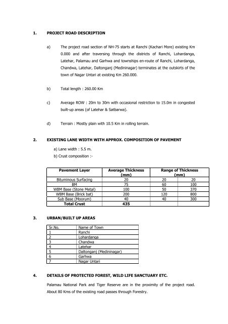
1. PROJECT ROAD DESCRIPTION<br />
a) The project road section of NH-75 starts at Ranchi (Kachari More) existing Km<br />
0.000 and after traversing through the districts of Ranchi, Lohardanga,<br />
Latehar, Palamau and Garhwa and townships en-route of Ranchi, Lohardanga,<br />
Chandwa, Latehar, Daltonganj (Medininagar) terminates at the outskirts of the<br />
town of Nagar Untari at existing Km 260.000.<br />
b) Total length : 260.00 Km<br />
c) Average ROW : 20m to 30m with occasional restriction to 15.0m in congested<br />
built-up areas (of Latehar & Satbarwa).<br />
d) Terrain : Mostly plain with 10.5 Km in rolling terrain.<br />
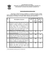
2. EXISTING LANE WIDTH WITH APPROX. COMPOSITION OF PAVEMENT<br />
a) Lane width : 5.5 m.<br />
b) Crust composition :-<br />
Pavement Layer Average Thickness Range of Thickness<br />
(mm)<br />
(mm)<br />
Bituminous Surfacing 20 20 20<br />
BM 75 60 100<br />
WBM Base (Stone Metal) 100 50 370<br />
WBM Base (Brick bat) 200 120 800<br />
Sub Base (Moorum) 40 40 300<br />
Total Crust 435<br />
3. URBAN/BUILT UP AREAS<br />
Sr.No. Name of Town<br />
1 Ranchi<br />
2 Lohardanga<br />
3 Chandwa<br />
4 Latehar<br />
5 Daltonganj (Medininagar)<br />
6 Garhwa<br />
7 Nagar Untari<br />
4. DETAILS OF PROTECTED FOREST, WILD LIFE SANCTUARY ETC.<br />
Palamau National Park and Tiger Reserve are in the proximity of the project road.<br />
About 80 Kms of the existing road passes through Forestry.