Coweta County Bike Routes
Coweta County Bike Routes
Coweta County Bike Routes

You also want an ePaper? Increase the reach of your titles
YUMPU automatically turns print PDFs into web optimized ePapers that Google loves.
<strong>Coweta</strong> <strong>County</strong> <strong>Bike</strong> <strong>Routes</strong><br />
Black Route: - 12.2 miles<br />
Begin on Broad Street at intersection with Wells Street in downtown Senoia<br />
Right onto Wells Street (.9 miles)<br />
Left onto Rockhouse Road (4 miles)<br />
Left onto Elders Mill Road (1.6 miles)<br />
Straight onto Gordon Road (4.4 miles)<br />
Right onto Todd Road (1.3 miles)<br />
End at Dolly Nixon Road (Little White House Route)<br />
Blue Route: - 23.2 miles<br />
Begin on Corinth Road at intersection with Millard Farmer Road<br />
Right onto Millard Farmer Road (2.5 miles)<br />
Right onto Old Corinth Road (2.0 miles)<br />
Left onto Smokey Road (11.0 miles)<br />
Left onto Corinth Road (3.0 miles)<br />
Right onto Bohannon Road -changes to Colley Street (4.7 miles)<br />
End at Lagrange Street in Grantville (Chattahoochee Trace Route)<br />
Green Route: - 52 miles<br />
Begin on Palmetto-Tyrone Road at intersection with Craig Wood Way<br />
Straight on Palmetto-Tyrone Road (1.2 miles)<br />
Right onto Minix Road at fork (4.0 miles)<br />
End at Fisher Road (Little White House Route)<br />
Orange Route: - 28.2 miles<br />
Begin on Georgia Highway 16 at intersection with Highway 34 by-pass<br />
Right onto Highway 34 by-pass -changes to Ishman Ballard Road (1.4 miles)<br />
Right onto Welcome Road (2.8 miles)<br />
Left onto Providence Church Road (1 mile)<br />
Right onto Keith Road -changes to Handy Road at Pierce Chapel Road (3.4 miles)<br />
Left onto Hoot Owl Hollow (1 mile)<br />
Left onto Handy Road (.5 miles)<br />
Left onto Thomas Powers Road (2.7 miles)<br />
Left onto Highway 34 (.5 miles)<br />
Right onto J.D. Walton Road (3.5 miles)<br />
Left onto Smokey Road (6.6 miles)<br />
Right onto Old Corinth Road (2 miles)<br />
Left onto Millard Farmer Road (2.75 miles)<br />
End at Cornith Road<br />
Purple Route: - 27.8 miles<br />
Begin on Edgeworth Road at intersection with Highway 29<br />
Straight on Edgeworth Road (.5 miles)<br />
Left onto Frank Hood Road (.5 miles)<br />
Left onto Hal Jones Road (.5 miles)<br />
Right onto Happy Valley Road (.3 miles)<br />
Left onto Buddy West Road (2.8 miles)<br />
Cross Roscoe Road -changes to Macedonia Road (2 miles)<br />
Right onto Newton Road (1.6 miles)<br />
Right onto Old Carrollton Highway (.5 miles)<br />
Right onto Sewell Mill Road (4.5 miles)<br />
Right onto Roscoe Road (.9 miles)<br />
Right onto Jim Starr Road (1.4 miles)<br />
Continue on Jim Starr Road (1.2 miles)<br />
Left onto Happy Valley Circle (5.4 miles)<br />
Left onto Edgeworth Road (.5 miles)<br />
End at Edgeworth and Highway 29<br />
<strong>Coweta</strong> <strong>County</strong> <strong>Bike</strong> <strong>Routes</strong><br />
Red Route: - 11.6 miles<br />
Enjoy your ride through... Begin on Corinth Road at intersection with Millard Farmer Road <strong>Coweta</strong> <strong>County</strong><br />
Right onto Millard Farmer Road (2.5 miles)<br />
Left onto Old Corinth Road (4.4 miles)<br />
Left onto Bohannon Road -changes to Colley Street (4.7 miles)<br />
End at Lagrange Street in Grantville<br />
Yellow Route: - 257 miles<br />
Begin on Highway 54 at intersection with Christopher Road<br />
Straight on Highway 54 (.4 miles)<br />
Right onto Steward Road (.5 miles)<br />
Right onto Smith Road (2 miles)<br />
Left onto Lower Fayetteville Road (3.8 miles)<br />
Left onto Mary Freeman Road (1.2 miles)<br />
Right onto Poplar Road (.10 miles)<br />
Left onto Goodwynn Road -changes to Raymond Sheddan Avenue (1.6 miles)<br />
Left onto Highway 16 (.4 miles)<br />
Right onto Martin Mill Road (.4 miles)<br />
Left onto Moore Road (2.9 miles)<br />
Left onto Gordon Road (4.0 miles)<br />
Left onto Johnson Road (2.2 miles)<br />
Right onto Linch Road (2.5 miles)<br />
Left onto South Hunter Road -changes to North Hunter (.7 miles)<br />
Right onto Odom Road (.6 miles)<br />
Left onto Reese Road (1.2 miles)<br />
Right onto McIntosh Trail (1.2 miles)
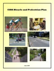
Welcome to <strong>Coweta</strong> <strong>County</strong> <strong>Bike</strong> Route System<br />
This brochure provides an overview<br />
of the routes and signage in the <strong>Coweta</strong> <strong>County</strong><br />
Bicycle Route System.<br />
The <strong>Coweta</strong> routes are oriented toward<br />
average recreational riders.<br />
Characterized by rolling hills, the<br />
routes generally follow the<br />
<strong>County</strong>’s lightly traveled network<br />
of rural and minor roads.<br />
Each route intersects with at least<br />
one of the three state-sponsored<br />
routes that cross the <strong>County</strong>.<br />
Motor vehicle traffic conditions in<br />
the <strong>County</strong> vary from heavy to light.<br />
To ensure your safety, please obey all<br />
traffic laws.<br />
Planning and development of the<br />
<strong>Coweta</strong> bicycle route system<br />
signs, brochures, and parking facilities<br />
was made possible by funding from the<br />
Transportation Equity Act for the 21st<br />
Century (TEA-21), U.S. Department of<br />
Transportation, and <strong>Coweta</strong> <strong>County</strong><br />
Board of Commissioners.<br />
Thomas Powe rs Rd.<br />
Highway 34 W.<br />
As a cyclist, please obey all traffic laws, including<br />
riding toward the outside edge of travel lanes,<br />
stopping at all intersections and red lights,<br />
and properly signaling when turning.<br />
As development patterns in the <strong>County</strong> vary<br />
from intensely suburban to mostly rural, motor<br />
vehicle traffic conditions may vary from heavy to<br />
light. Because some drivers in <strong>Coweta</strong> are still<br />
unfamiliar with sharing the road with bicycles,<br />
riders should use caution when using heavily traveled<br />
thoroughfares. The state of bicycling in <strong>Coweta</strong> will<br />
undoubtedly benefit from an increasing presence and<br />
visibility of cyclists on <strong>County</strong> roads. As motorists are<br />
acclimated to the idea of sharing space, safety will improve.<br />
Route Guide<br />
Handy Rd.<br />
Smokey Rd .<br />
BLACK Route:<br />
BLUE Route:<br />
J D Walt on Rd.<br />
Keith Rd.<br />
Corinth Rd.<br />
GREEN Route:<br />
ORANGE Route:<br />
Welcome Rd.<br />
Smokey Rd.<br />
Holbroo k Rd<br />
Newton Rd.<br />
Bohanno n Rd.<br />
Sewell Mill Rd.<br />
Old Corinth Rd.<br />
Maced onia Rd. Buddy-west Rd.<br />
Millard Farmer Rd.<br />
Chatt ohoochee Trac e St. Rte.<br />
Roscoe Rd.<br />
Ishman Ballard Rd.<br />
PURPLE Route:<br />
RED Route:<br />
Jim Starr Rd.<br />
Jim Starr Rd.<br />
Happy Valley Cir.<br />
Edgeworth Rd.<br />
YELLOW Route:<br />
RED Route:<br />
85<br />
Goodwynn Rd.<br />
Moore Rd.<br />
Gordan Rd.<br />
CENTRAL State Route:<br />
CHATTAHOOCHEE State Route:<br />
Gordan Rd.<br />
Little Whit e House St. Rt.<br />
Linch Rd.<br />
Johnson Rd.<br />
Smith Rd.<br />
Central St. Rte.<br />
Elders Mill Rd.<br />
M inix<br />
Rd.<br />
N. Hunter St.<br />
Reese Rd.<br />
Mcintosh Tri.<br />
R oc k House Rd. Wells S t.<br />
Gordon Rd.<br />
Todd Rd.<br />
LITTLE WHITE HOUSE State Route:<br />
HERITAGE Highway:<br />
TOWNS:<br />
INTERSTATE:<br />
RAILROADS: