Land Subsidence in Semarang Municipality - BGR
Land Subsidence in Semarang Municipality - BGR
Land Subsidence in Semarang Municipality - BGR

You also want an ePaper? Increase the reach of your titles
YUMPU automatically turns print PDFs into web optimized ePapers that Google loves.
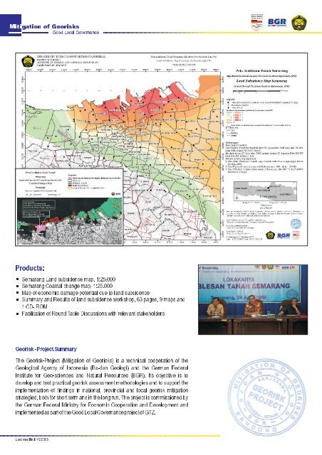
Mitigation of Georisks<br />
Good Local Governance<br />
Products:<br />
< <strong>Semarang</strong><strong>Land</strong>subsidencemap,1:25.000<br />
< <strong>Semarang</strong>Coastalchangemap,1:25.000<br />
< Mapofeconomicdamagepotentialduetolandsubsidence<br />
< SummaryandResultsoflandsubsidenceworkshop,63pages,9mapsand<br />
1CD-ROM<br />
< FacilitationofRoundTableDiscussionswithrelevantstakeholders<br />
Georisk-ProjectSummary<br />
The Georisk-Project (Mitigation of Georisks) is a technical cooperation of the<br />
Geological Agency of Indonesia (Ba-dan Geologi) and the German Federal<br />
Institute for Geo-sciences and Natural Resources (<strong>BGR</strong>). Its objective is to<br />
developandtestpracticalgeoriskassessmentmethodologiesandtosupportthe<br />
implementation of f<strong>in</strong>d<strong>in</strong>gs <strong>in</strong> national, prov<strong>in</strong>cial and local georisk<br />
mitigation<br />
strategies, bothforshorttermand<strong>in</strong>thelongrun.Theprojectiscommissionedby<br />
the German Federal M<strong>in</strong>istry for Economic Cooperation and Development and<br />
implementedaspartoftheGoodLocalGovernanceprojectofGTZ.<br />
Last modified: 10/2008

![Tröpfis weltweite Abenteuer [deutsch] (PDF, 6 MB) - BGR - Bund.de](https://img.yumpu.com/13203261/1/184x260/tropfis-weltweite-abenteuer-deutsch-pdf-6-mb-bgr-bundde.jpg?quality=85)