Land Subsidence in Semarang Municipality - BGR
Land Subsidence in Semarang Municipality - BGR
Land Subsidence in Semarang Municipality - BGR
You also want an ePaper? Increase the reach of your titles
YUMPU automatically turns print PDFs into web optimized ePapers that Google loves.
Mitigation of Georisks<br />
Good Local Governance<br />
Indonesian-German Technical Cooperation<br />
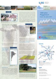
<strong>Land</strong> <strong>Subsidence</strong> <strong>in</strong> <strong>Semarang</strong> <strong>Municipality</strong><br />
0 50 100 Km<br />
Kota <strong>Semarang</strong><br />
JAVA<br />
<strong>Land</strong>sub Photo<br />
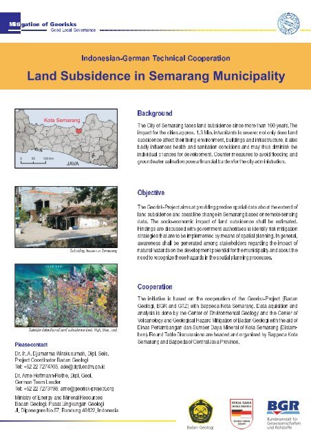
Subsid<strong>in</strong>g houses <strong>in</strong><strong>Semarang</strong><br />
Satellite detection oflandsubsidence (red:high,blue:low)<br />
Pleasecontact<br />
Dr.Ir.A.DjumarmaWirakusumah,Dipl.Seis.<br />
ProjectCoord<strong>in</strong>atorBadanGeologi<br />
Tel:+62227274705,ade@dgtl.esdm.go.id<br />
Dr.ArneHoffmann-Rothe,Dipl.Geol.<br />
GermanTeamLeader<br />
Tel:+62227273198,arne@georisk-project.org<br />
M<strong>in</strong>istryofEnergyandM<strong>in</strong>eralResources<br />
BadanGeologi,PusatL<strong>in</strong>gkunganGeologi<br />
Jl.DiponegoroNo57,Bandung40122,Indonesia<br />
Background<br />
TheCityof<strong>Semarang</strong>faceslandsubsidences<strong>in</strong>cemorethan100years.The<br />
impactforthecitiesapprox.1.3Mio.<strong>in</strong>habitantsissevere:notonlydoesland<br />
subsidenceaffecttheirliv<strong>in</strong>genvironment,build<strong>in</strong>gsand<strong>in</strong>frastructure,italso<br />
badly <strong>in</strong>fluences health and sanitation conditions and may thus dim<strong>in</strong>ish the<br />
<strong>in</strong>dividualchancesfordevelopment.Countermeasurestoavoidflood<strong>in</strong>gand<br />
groundwatersal<strong>in</strong>ationposeaf<strong>in</strong>ancialburdenforthecityadm<strong>in</strong>istration.<br />
Objective<br />
TheGeorisk-Projectaimsatprovid<strong>in</strong>gprecisespatialdataabouttheextendof<br />
landsubsidenceandcoastl<strong>in</strong>echange<strong>in</strong><strong>Semarang</strong>basedonremotesens<strong>in</strong>g<br />
data. The socio-economic impact of land subsidence shall be estimated.<br />
F<strong>in</strong>d<strong>in</strong>gsarediscussedwithgovernmentauthorituestoidentifyriskmitigation<br />
strategiesthataretobeimplementedbymeansofspatialplann<strong>in</strong>g.Ingeneral,<br />
awareness shall be generated among stakeholders regard<strong>in</strong>g the impact of<br />
naturalhazardsonthedevelopmentpotentialforthemunicipalityandaboutthe<br />
needtorecognizethesehazards<strong>in</strong>thespatialplann<strong>in</strong>gprocesses.<br />
Cooperation<br />
The <strong>in</strong>itiative is based on the cooperation of the Georisk-Project (Badan<br />
Geologi, <strong>BGR</strong> and GTZ) with Bappeda Kota <strong>Semarang</strong>. Data aquisition and<br />
analysis is done by the Center of Environmental Geology and the Center of<br />
VolcanologyandGeologicalHazardMitigationofBadanGeologiwiththeaidof<br />
D<strong>in</strong>asPertambangandanSumberDayaM<strong>in</strong>eralofKota<strong>Semarang</strong>(Distamben).RoundTableDiscusssionsareheadedandorganisedbyBappedaKota<br />
<strong>Semarang</strong>andBappedaofCentralJavaProv<strong>in</strong>ce.
Mitigation of Georisks<br />
Good Local Governance<br />
Products:<br />
< <strong>Semarang</strong><strong>Land</strong>subsidencemap,1:25.000<br />
< <strong>Semarang</strong>Coastalchangemap,1:25.000<br />
< Mapofeconomicdamagepotentialduetolandsubsidence<br />
< SummaryandResultsoflandsubsidenceworkshop,63pages,9mapsand<br />
1CD-ROM<br />
< FacilitationofRoundTableDiscussionswithrelevantstakeholders<br />
Georisk-ProjectSummary<br />
The Georisk-Project (Mitigation of Georisks) is a technical cooperation of the<br />
Geological Agency of Indonesia (Ba-dan Geologi) and the German Federal<br />
Institute for Geo-sciences and Natural Resources (<strong>BGR</strong>). Its objective is to<br />
developandtestpracticalgeoriskassessmentmethodologiesandtosupportthe<br />
implementation of f<strong>in</strong>d<strong>in</strong>gs <strong>in</strong> national, prov<strong>in</strong>cial and local georisk<br />
mitigation<br />
strategies, bothforshorttermand<strong>in</strong>thelongrun.Theprojectiscommissionedby<br />
the German Federal M<strong>in</strong>istry for Economic Cooperation and Development and<br />
implementedaspartoftheGoodLocalGovernanceprojectofGTZ.<br />
Last modified: 10/2008



![Tröpfis weltweite Abenteuer [deutsch] (PDF, 6 MB) - BGR - Bund.de](https://img.yumpu.com/13203261/1/184x260/tropfis-weltweite-abenteuer-deutsch-pdf-6-mb-bgr-bundde.jpg?quality=85)

