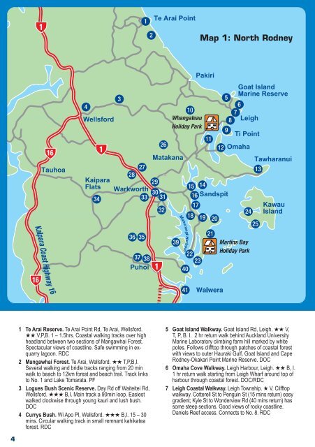
4 1 Te Arai Reserve. Te Arai Po<strong>in</strong>t Rd, Te Arai, Wellsford. ★★ V,P,B. 1 – 1.5hrs. Coastal walk<strong>in</strong>g <strong>tracks</strong> over high headland between two sections of Mangawhai Forest. Spectacular views of coastl<strong>in</strong>e. Safe swimm<strong>in</strong>g <strong>in</strong> exquarry lagoon. RDC 2 Mangawhai Forest. Te Arai, Wellsford. ★★ T,P,B,I. Several walk<strong>in</strong>g and bridle <strong>tracks</strong> rang<strong>in</strong>g from 20 m<strong>in</strong> walk to beach to 12km forest and beach trail. Track l<strong>in</strong>ks to No. 1 and Lake Tomarata. PF 3 Logues Bush Scenic Reserve. Day Rd off Waiteitei Rd, Wellsford. ★★★ B,I. Ma<strong>in</strong> track a 90m<strong>in</strong> loop. Easiest walked clockwise through young kauri and lush bush. DOC 4 Currys Bush. Wi Apo Pl, Wellsford. ★★★ B,I. 15 – 30 m<strong>in</strong>s. Circular walk<strong>in</strong>g track <strong>in</strong> small remnant kahikatea forest. RDC Map 1: North <strong>Rodney</strong> 5 Goat Island Walkway. Goat Island Rd, Leigh. ★★ V, T, P, B. I. 2 hr return walk beh<strong>in</strong>d <strong>Auckland</strong> University Mar<strong>in</strong>e Laboratory climb<strong>in</strong>g farm hill marked by white poles. Follows clifftop through patches of coastal forest with views to outer Hauraki Gulf, Goat Island and Cape <strong>Rodney</strong>-Okakari Po<strong>in</strong>t Mar<strong>in</strong>e Reserve. DOC 6 Omaha Cove Walkway. Leigh Harbour, Leigh. ★★ B, I. 1 hr return walk start<strong>in</strong>g from Leigh Wharf around top of harbour through coastal forest. DOC/RDC 7 Leigh Coastal Walkway. Leigh Township. ★ V. Clifftop walkway. Cotterell St to Pengu<strong>in</strong> St (15 m<strong>in</strong>s return) easy gradient; Kyle St to Wonderview Rd (40 m<strong>in</strong>s return) has some steep sections. Good views of rocky coastl<strong>in</strong>e. Daniels Reef access. Connects to No. 8. RDC
8 Matheson Bay Reserve. Grand View/Matheson Bay Rd, Matheson Bay. ★ T, P, B. 40 m<strong>in</strong>. return walk from reserve carpark along southern side of Kohuroa Stream. Muddy when wet. Popular swimm<strong>in</strong>g and div<strong>in</strong>g area. RDC 9 Ti Po<strong>in</strong>t Coastal Walkway. Ti Po<strong>in</strong>t Rd, Ti Po<strong>in</strong>t. ★ T. 2 hr return walk start<strong>in</strong>g from jetty around foreshore to Ti Po<strong>in</strong>t Scenic Reserve (DOC). Private property to Tatham Rd from Scenic Reserve. Popular fish<strong>in</strong>g spot off rocks. RDC/DOC 10 Mt Tamahunga Walkway. 3.6 km down Omaha Valley Rd (off Leigh Rd), Matakana, or start end of <strong>Rodney</strong> Rd or Bathgate Rd, Pakiri. ★ V,P, B, I. 1.5 hrs one way to summit, 3.5 hrs one way to <strong>Rodney</strong> Rd, or 4.5 hrs from Omaha Valley Rd to Pakiri. Magnificent views up and down coast. Track is marked. TA/RDC/DOC. 11 Po<strong>in</strong>t Wells Reserve. Riverside Dr, Po<strong>in</strong>t Wells.★★★ T,P. 45 m<strong>in</strong>. return walk start<strong>in</strong>g from boatramp, around grass foreshore reserve beside Whangateau Harbour and follow<strong>in</strong>g bollard markers to Waimanu Reserve/Pl. Return the same way or walk back through village via accessway to Harbour View Rd. RDC 12 Omaha Beach. Omaha. ★★★ T,P. A variety of walks <strong>in</strong> area <strong>in</strong>clud<strong>in</strong>g reserves, foreshore and boardwalks. Dogs not permitted <strong>in</strong> dotterel bird sanctuary at top end of spit. Several start<strong>in</strong>g po<strong>in</strong>ts for a range of shorter and longer walks <strong>in</strong>clud<strong>in</strong>g wetlands and quarry. RDC 13 Tawharanui Regional Park. Takatu Rd, Matakana. V,T,P,B,I. A 588ha Open Sanctuary protected by a predator-proof fence. A range of coastal walks. ARC 14 Buckleton Beach. Buckleton Rd. ★★ P, B. 30 – 40 m<strong>in</strong>s. A circular walk start<strong>in</strong>g from boatramp. Go left along beach reserve, follow grass track up hill <strong>in</strong>to reserve with small area of bush. Follow track through bush to accessway (with steps back onto Buckleton Rd). Follow the road back to ramp. RDC 15 Sandspit Spit. Sandspit Rd, Sandspit. ★★★ D,T,P. A pleasant return walk (45 m<strong>in</strong>s) through the reserves on the spit; boardwalks through mangroves, past Deans Island and bird roost<strong>in</strong>g area on sandbar. Go through camp to No. 16. RDC 16 Brick Bay Reserve. Brick Bay Dr, Sandspit. ★★ T,B. 1.5-2 hrs. A series of bush <strong>tracks</strong> developed by local community through bush reserves overlook<strong>in</strong>g the mouth of the Matakana River. Various entry po<strong>in</strong>ts: off end of Kotare Pl, Puriri Pl, lefthand side near Brick Bay Dr <strong>in</strong>tersection, and beach reserve end of Brick Bay Dr. RDC 17 Snells Beach Beachfront Reserve. Snells Beach Rd, Snells Beach. ★★★ D,T,P. Walkway along beachfront. Range of short and long walks. RDC 18 Goodall Reserve. Cnr Hamatana and Mahurangi East Roads, Snells Beach. ★★★ D,T,P. 45 – 60 m<strong>in</strong>s. A circular walk around this reserve. Concrete path through to Foster Cres. and metal track on lower slop<strong>in</strong>g area. Toilets by tennis courts. RDC 19 Algies Bay/Highfield Garden Reserve. Gordon Craig Pl / Mahurangi East Rd, Algies Bay. ★★ V,T,P,B,I. 60 – 90 m<strong>in</strong>s. A walk along beachfront reserve to Highfield Garden Reserve at north end to see the donkeys and water fowl. Return along beach, take a stroll towards the southern end through the attractive garden area on the esplanade reserve. Map on sign by toilets. RDC 20 Scandrett Regional Park. Scandrett Rd, Snells Beach. ★ V,T,P,H,I. Various walks with l<strong>in</strong>ks to Mart<strong>in</strong>s Bay Holiday Park. ARC 21 Mart<strong>in</strong>s Bay Reserve. Mart<strong>in</strong>s Bay Rd, Mart<strong>in</strong>s Bay. ★★ P,B,T,I. 90 m<strong>in</strong>s. Map on sign at ma<strong>in</strong> carpark to left of boatramp. Cross stiles and through grazed area to reach bush area beh<strong>in</strong>d campground. Track has been upgraded but is muddy and slippery when wet. RDC 22 Scotts Land<strong>in</strong>g. Ridge Rd, Mahurangi East. ★ V,T,P,B,H,I. Walkway l<strong>in</strong>k<strong>in</strong>g several reserves <strong>in</strong>clud<strong>in</strong>g Mahurangi and Burton Wells Scenic Reserves (DOC) and Mahurangi Regional Park (ARC) with historic Scott homestead. Some tidal sections. Sign with map at Williams St carpark. Range of short and long walks. RDC/DOC/ARC 23 Mahurangi East – Poplar Bay. Mahurangi Pen<strong>in</strong>sula. ★★ V,I. 30 m<strong>in</strong>s one way. <strong>Walk<strong>in</strong>g</strong> track at Mahurangi Regional Park on headland east of Scotts Land<strong>in</strong>g between Poplar and Lagoon Bays. Access by boat only. ARC 24 Mansion House. Kawau Island. ★★★ V,T,H,I. A series of walks from Mansion House to old copper m<strong>in</strong>e and School House Bay. View Sir George Grey’s house, grounds and wallabies. Take ferry from Sandspit. Range of short and long walks. DOC 25 South Cove. Kawau Island. ★★ V. A pleasant return walk from South Cove wharf through small settlement and p<strong>in</strong>e plantation. Good views of Hauraki Gulf Islands. Take ferry from Sandspit or use own boat. RDC 26 Govan Wilson Rd to Dome Forest. Govan Wilson Rd, Matakana. ★ P, B, I. 7 hours one way. Note: shorter walks optional. Bush walks with views. Track is marked. TA/DOC/ RDC. 27 Dome Forest Walkway. Dome Forest carpark (tearooms), SH 1, Warkworth. ★★ V, P, B, I. 60 – 90 m<strong>in</strong>s. 1.2km return track to the Dome summit, steep and rocky ascent. Alternatively a shorter 40 m<strong>in</strong> return walk to the lookout platform. A small kauri grove 800m beyond the summit. DOC 28 Dome Forest to Puhoi. Dome Forest carpark (tearooms), SH 1, Warkworth. ★ & ★★ V, T, P, T. Full day: 6-7 hrs one way. Immediately across SH1 from the tearooms is Kraack Rd. Follow small directional markers on road signs from here to traverse back country roads, bush, forest and farms to Puhoi. The general directions are: Kraack Rd, Smyth Rd, Streamlands Swamp Rd, Old Kaipara Rd, Dr<strong>in</strong>nan’s farm, Edgerley Rd, Mathew Rd, Moirs Hill, signed 4WD track to Ahuroa Rd, Tolhopf Rd (connects with Dunn’s Bush/Ridge Track – see No. 37), then Ahuroa Rd <strong>in</strong>to Puhoi. RDC/TA. 29 Kowhai Park. S.H.1/Matakana Rd, Warkworth. ★★★ T,P,B,H. 45 – 60 m<strong>in</strong>s. Circular bush walk, past historic lime kilns. Parts can be muddy when wet. RDC 30 Warkworth Town Riverbank. Wharf Rd/Kapanui St, Warkworth. ★★★ T,P. A walkway extend<strong>in</strong>g along the town side of Mahurangi River from Fall St, Elizabeth St, the wharf and Baxter St <strong>in</strong>to Lucy Moore Park, Rivendell Pl. and extend<strong>in</strong>g to historic cement works off Wilson Rd. Range of short and long walks. RDC 31 Warkworth 150th Anniversary Walkway. ★★★ V. 15 m<strong>in</strong>s. From Elizabeth Street along the river, boardwalk under highway to Shoesmith Reserve. RDC For walks 32-41, see page 6 5