Lab 4: Plate Tectonics – Locating Geologic Hazards
Lab 4: Plate Tectonics – Locating Geologic Hazards
Lab 4: Plate Tectonics – Locating Geologic Hazards

You also want an ePaper? Increase the reach of your titles
YUMPU automatically turns print PDFs into web optimized ePapers that Google loves.
Introduction<br />
<strong>Lab</strong> 4: <strong>Plate</strong> <strong>Tectonics</strong> <strong>–</strong> <strong>Locating</strong> <strong>Geologic</strong> <strong>Hazards</strong><br />
The likelihood of major geologic hazards associated with the lithosphere, such as<br />
earthquakes and volcanoes, is not uniform around the Earth's surface. Rather, there are<br />
well-defined linear belts of earthquake and seismic activity that can be readily identified.<br />
In the 1960s and 1970s, these belts were recognized as the boundaries of large plates that<br />
moved around the Earth's surface. Thus, the theory of plate tectonics was developed.<br />
This theory provides a ready explanation for the distribution of these types of geologic<br />
hazards. It is useful for preparedness plan because it tells us what regions are subject to<br />
what types of geologic hazards, the potential magnitude of these events and a crude<br />
estimate of their recurrence times. Thus, a basic understanding of the theory of plate<br />
tectonics is useful for understanding the major geologic hazards. (It is also helpful in the<br />
exploration for Earth resources).<br />
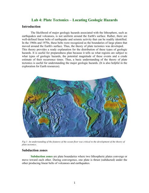
Fig.1: An understanding of the features of the ocean floor was critical to the development of the theory of<br />
plate tectonics.<br />
Subduction zones<br />
Subduction zones are plate boundaries where two lithospheric plates converge or<br />
move toward each other. During convergence, one plate is thrust (subducted) under the<br />
other producing linear belts of volcanoes and earthquakes.<br />
1
Schematic cross-section through a subduction zone.<br />
Subduction zones are regions of significant geologic hazards as well as the host of<br />
certain types of Earth resources.<br />
Types<br />
Subduction zones are classified based on the types of plates that are colliding. Based<br />
on this, there are three types of subduction zones.<br />
• ocean-ocean: two oceanic plates are colliding therefore cannot predict which will<br />
be subducted; associated volcanoes produce an oceanic island arc on the<br />
overriding plate<br />
• ocean-continent: an oceanic plate (the denser) is subducted beneath the<br />
continental plate; volcanoes form a continental arc on the edge of the overriding<br />
continental plate<br />
• continent-continent: two continental plates collide, because they are both of low<br />
density, neither is subducted, no volcanoes, forms high mountain range with large<br />
earthquakes<br />
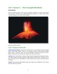
Volcanoes<br />
Some of the most explosive volcanoes are associated with subduction zones. They<br />
are the classic composite volcano with its characteristic symmetrical profile. These<br />
volcanoes erupt lavas with high gas content and viscosity which often leads to very high<br />
explosivity.<br />
2
Some of the most powerful historic eruptions have been of subduction zone<br />
volcanoes. These include:<br />
• Tambora, Indonesia in 1815<br />
• Krakatoa, Indonesia in 1883<br />
• Mount Pele, Martinique in 1902<br />
• Katami in 1910<br />
• Mount Pinatubo, Philippines in 1986<br />
Earthquakes<br />
The largest earthquakes that occur on Earth are associated with subduction zones.<br />
These quakes vary in depth from a few kilometers to more than 100 km. They also affect<br />
very large areas and can have long durations, e.g. several minutes. Many of the most<br />
destructive earthquakes have occurred along subduction zones. Unfortunately, a large<br />
percentage of the world's population lives near subduction zones putting them at great<br />
risk from this geologic hazard. Important subduction zone earthquakes include:<br />
• Good Friday earthquake in Alaska, 1964<br />
• Chile earthquake, 1960<br />
These are the three strongest earthquakes ever recorded.<br />
3
Damage in Anchorage, Alaska produced by the 1964 earthquake.<br />
Wadati-Benioff zone<br />
A dipping planar (flat) zone of earthquakes that is produced by the interaction of a<br />
downgoing oceanic crustal plate with a continental plate. These earthquakes can be<br />
produced by slip along the subduction thrust fault or by slip on faults within the<br />
downgoing plate as a result of bending and extension as the plate is pulled into the<br />
mantle. (from http://earthquake.usgs.gov)<br />
Schematic cross-section through a subduction zone.<br />
4
Divergent boundaries<br />
1. rifting occurs when currents in the asthenosphere pulls-apart and tears a preexisting<br />
plate<br />
a. Great Rift Valley of East Africa is a prime example of rifting<br />
b. Red Sea and the Gulf of Aden occur in basins produced by rifting that<br />
separated the Arabian plate from the African plate<br />
2. as the smaller plates continue separating from one another they diverge<br />
a. typical rates are about 1 to 9 centimeters (0.5-4 inches) per year<br />
3. molten rock rises in the center of the rift<br />
a. cools and solidifies, becoming attached to the edges of the rifted plates<br />
4. if divergence continues, further separating the older rifted segments, eventually an<br />
ocean basin may be formed<br />
5. creating new oceanic lithosphere that builds up to form the mid-ocean ridges<br />
a. a continuous chain of submarine mountains that bisects the world’s oceans<br />
6. process of plate growth at mid-ocean ridges is known as sea-floor spreading<br />
(form http://stloe.most.go.th)<br />
Transform margins<br />
5
Transforms, also referred to as transform faults, are conservative plate<br />
boundaries, i.e. plates are neither created nor destroyed there rather they are conserved.<br />
Along a transform, one plate slides past the other so there is neither subduction nor<br />
magma ascent.<br />
Transforms form the smallest percentage of the plate margins and represent a<br />
fundamental development in the theory of plate tectonics. They were originally described<br />
by the Canadian geologist J. Tuzo Wilson.<br />
Connector<br />
Transforms are the geometrical element that joins different types of plate boundaries.<br />
Without them, the physics of rigid plates on a spherical surface would prevent plate<br />
tectonics from occurring. There are three possible of plate boundaries that can be joined<br />
by transforms:<br />
• divergent-divergent:<br />
• divergent-convergent: San Andreas Fault, Queen Charlotte Fault (off BC);<br />
Mediterranean area, South Atlantic<br />
• convergent-convergent: Caribbean, South Atlantic, Asia<br />
Features<br />
The most common type of transform connection is divergent-divergent (or ridgeridge).<br />
A careful observation of the the mid-ocean ridge system reveals that is is not a<br />
continuous linear feature, but that it is broken up into short linear segments 200-800 km<br />
long. This produces the characteristic stair-step pattern of the mid-ocean ridge system.<br />
6
The linear features that offset the ridge crest are transforms. They extend for<br />
thousands of kilometers across the ocean floor and form impressive cliffs that may tower<br />
1-2 km above the surrounding ocean floor. Topographic features and magnetic anomalies<br />
that cross these transforms may be displaced as much as 1000 km from each other. There<br />
is also a significant difference in the age of oceanic crust on opposite sides of the<br />
transform.<br />
<strong>Hazards</strong><br />
Along transform boundaries, two lithospheric plates slide past each other.<br />
However, in most cases motion is not uniform but occurs in a series of events or ruptures.<br />
These occur when the stress accumulated along the fault exceeds the strength of the lock<br />
that has been preventing the plates from moving. When this happens, an earthquake<br />
occurs. Because plates are neither created nor destroyed at transforms, they are not<br />
marked by volcanic activity. Thus, the primary lithospheric-driven geologic hazard<br />
accompanying transform boundaries is earthquakes.<br />
Transform fault earthquakes:<br />
• occur at shallow depths (
outside of the ridge crests. These linear, aseismic extensions of the transforms are<br />
fracture zones.<br />
• between crest two plates moving in opposite directions - friction produces quakes<br />
• outside crests plates moving in same direction and at same rate - no friction to<br />
produce earthquakes<br />
• the offset of the magnetic stripes was originally produced at the ridges and don't<br />
get bigger with time<br />
This distribution is a result of the plate motions along the ridge system.<br />
8
Reference:<br />
• Beloussov, V.V., 1979, Why I do not accept plate tectonics: EOS, vol. 60, pp.<br />
207-210.<br />
• Boling, R., 1996, How to move a continent. Earth, vol. 5, pp. 14.<br />
• Bonatti, E., 1987, The rifting of continents: Scientific American, vol. 256, no. 3,<br />
pp. 96-103.<br />
• Bonatti, E., 1994, The Earth's mantle below the oceans: Scientific American, vol.<br />
270, no. 3, pp. 44-51.<br />
• Bonatti, E., and K. Crane, 1984, Ocean fracture zones: Scientific American, vol.<br />
250, no. 5, pp. 40-41.<br />
• Brimhall, G., 1991, The genesis of ores. Scientific American, vol. 264, pp. 84-91.<br />
• Canby, T.Y., 1990, California earthquake - preclude to the big one?: National<br />
Geographic, vol. 177, pp. 76-105.<br />
• Clark, G.C., 1995, Swallowed Up: Earth, vol. 3, pp. 34-41.<br />
• Courtillot, V. and G.E. Vink, 1983, How continents break up. American&<br />
Scientist, vol. 249, no. 1, pp. 42-47.<br />
• Davidson, K., 1994, Predicting earthquakes. Can it be done?: Earth, vol. 3, pp.<br />
56-63.<br />
• Dalziel, I.W.D., 1995, Earth before Pangea: Scientific American, vol. 272, no. 1,<br />
pp. 58-63.<br />
• Davidson, K., 1994, Learning from Los Angeles: Earth, vol. 3, pp. 40-47.<br />
• Dvorak, J., and T. Peek, 1993, Swept away the power of tsunamis: Earth, vol. 2,<br />
pp. 52-59.<br />
• Francheteau, J., 1983, The oceanic crust: Scientific American, vol. 249, no. 3, pp.<br />
68-84.<br />
• Frohlich, C., 1989, Deep earthquakes: Scientific American, vol. 260, pp. 48-55.<br />
• Gore, R., 1995, California earthquakes: National Geographic, vol. 187, pp. 2-37.<br />
• Green, H.W., II, 1994, Solving the paradox of deep earthquakes: Scientific<br />
American, vol. 271, pp. 64-71.<br />
• Johnston, A., 1992, New Madrid: the rift, the river and the earthquake: Earth, vol.<br />
1, pp. 34-43.<br />
• Johnston, A.C., and L.R. Kanter, 1990, Earthquakes in stable continental crust:<br />
Scientific American, vol. 262, pp.68-75.<br />
• Jordan, T.H., and J.B. Minster, 1988, Measuring crustal deformation in<br />
the American west. Scientific American, vol. 259, pp. 48-59.<br />
• MacDonald, K.C., and P.J. Fox, 1990, The mid-ocean ridge: Scientific American,<br />
vol. 262, no. 6, pp. 72-79.<br />
• McCredie, S. 1994, Tsunamis: The wrath of Poseidon: Smithsonian, vol. 24, pp.<br />
28-39.<br />
• Monastersky, R., 1993, Lessons from Landers: Earth, vol. 2, pp. 40-47.<br />
• Morgan, W.J., 1968, Rises, trenches, great faults and crustal blocks: J. Geophys.<br />
Res., vol. 73, pp. 1959-1982.<br />
• Murphy, J.B., and R.D. Nance, 1992, Mountain belts and the<br />
supercontinent cycle. Scientific American, vol. 266, pp. 84-91.<br />
9
• Nance, R.D., T.R. Worsley and J.B. Moody, 1988, The supercontinent<br />
cycle. Scientific American, vol. 259, pp. 72-79.<br />
• Parks, N., 1994, Exploring Loihi: the next Hawaiian Island. Earth, vol. 3, pp. 56-<br />
63.<br />
• Pendick, D., 1997, Waves of destruction: Earth, vol. 6, pp. 28-29.<br />
• Stein, R.S., and R.C. Buckman, 1986, Quake replay in the Great Basin: Natural<br />
History, vol. (June), pp. 29-35.<br />
• Stein, R.S., and R.S. Yeats, 1989, Hidden earthquakes: Scientific American, vol.<br />
260, pp. 48-59.<br />
• Vine, F.J., and D.H. Matthews, 1963, Magnetic anomalies over ocean ridges:<br />
Nature, vol. 199, pp. 947-949.<br />
• Vink, G.E., W.J. Morgan and P.R. Vogt, 1985, The Earth's hot spots: Scientific<br />
American, vol. 252, no. 4, pp. 50-56.<br />
• Bird, J.M., (ed.), 1980, <strong>Plate</strong> <strong>Tectonics</strong> (2 nd ed.), Washington, D.C., American<br />
Geophysical Union.<br />
• Bulter, R.F., 1992, Paleomagnetism. Blackwell Scientific Publications, Palo Alto,<br />
CA.<br />
• Condie, K., 1997, <strong>Plate</strong> <strong>Tectonics</strong> and Crustal Evolution (4th ed.),<br />
Butterworth/Heinemann, New York.<br />
• Cox, A. (ed.), 1973, <strong>Plate</strong> <strong>Tectonics</strong> and Geomagnetic Reversals. W.H. Freeman,<br />
New York.<br />
• Cox, A., and R.B. Hart, 1986, <strong>Plate</strong> <strong>Tectonics</strong>: How It Works. Blackwell<br />
Scientific Publications, Palo Alto, CA.<br />
• Hallam, A., 1973, A Revolution in the Earth Sciences: From Continental Drift to<br />
<strong>Plate</strong> <strong>Tectonics</strong>. Oxford University Press, London.<br />
• Kearev, P., and F.J. Vine, 1996, Global <strong>Tectonics</strong> (2 nd ed.). Blackwell Scientific<br />
Publications, Palo Alto, CA.<br />
• Klein, G.D. (ed.), 1994, Pangaea: Ppaleoclimate, <strong>Tectonics</strong>, and Sedimentation<br />
during Accretion, Zenith, and Breakup of a Supercontinent. <strong>Geologic</strong>al Society of<br />
America Special paper 288.<br />
• Moores, E.M., and R.J. Twiss, 1995, <strong>Tectonics</strong>. W.H. Freeman, New York.<br />
• Press, F., and R. Siever, 1974, Planet Earth - Readings from Scientific American.<br />
W.H. Freeman, New York.<br />
• Uyeda, S., 1978, The New Views of the Earth - Moving Continents and Moving<br />
Oceans. W.H. Freeman, New York.<br />
• Van Andel, T.H., 1985, New Views of an Old Planet. Cambridge University<br />
Press, New York.<br />
• Wegener, A., 1924, The Origin of Continents and Oceans. Methuen, London.<br />
• Wilson, J.T. (ed.), 1976, Continents Adrift and Continents Aground. W.H.<br />
Freeman, New York.<br />
• Windley, B.F., 1984, The Evolving Continents. Wiley, New York.<br />
10