

responsiveness summary to public comments - US Environmental ...
responsiveness summary to public comments - US Environmental ...
responsiveness summary to public comments - US Environmental ...

Create successful ePaper yourself
Turn your PDF publications into a flip-book with our unique Google optimized e-Paper software.
Page 30 of 40<br />
be developed so that natural dissolved oxygen concentrations, as determined on a regional or<br />
watershed basis, are maintained.<br />
Pollutant Name Change: Volatile Suspended Solids (VSS) or Non-VSS (NVSS) <strong>to</strong><br />
Non-Filterable Residue (NFR) or Sediment<br />
Comment: MDNR provided documentation <strong>to</strong> support the State’s pollutant name<br />
change from “NFR or Sediment” <strong>to</strong> “VSS or NVSS” for 30 water segments. The documentation<br />
from which this information was derived came in the form of visual benthic survey field data<br />
sheets.<br />
EPA Response: EPA disapproved this pollutant name change on the basis that MDNR<br />
had not provided any data that supported a discrete pollutant name change. As such, EPA added<br />
the applicable pollutant (i.e., NFR or sediment) back <strong>to</strong> 22 waterbodies which EPA had identified<br />
in Table 3 of Enclosure 2 <strong>to</strong> EPA’s April 29, 2003 decision letter <strong>to</strong> Missouri regarding their<br />
303(d) list. EPA reviewed the field survey data sheets which were provided by MDNR during<br />
EPA’s <strong>public</strong> comment period and agree that the description of benthic conditions described<br />
therein more clearly demonstrate which portion (i.e., VSS or NVSS) of <strong>to</strong>tal sediment is the<br />
problem. Based on this documentation EPA is making the following revisions <strong>to</strong> Missouri’s<br />
303(d) list.<br />
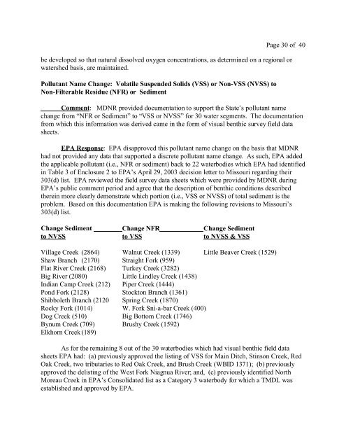
Change Sediment Change NFR Change Sediment<br />
<strong>to</strong> NVSS <strong>to</strong> VSS <strong>to</strong> NVSS & VSS<br />
Village Creek (2864) Walnut Creek (1339) Little Beaver Creek (1529)<br />
Shaw Branch (2170) Straight Fork (959)<br />
Flat River Creek (2168) Turkey Creek (3282)<br />
Big River (2080) Little Lindley Creek (1438)<br />
Indian Camp Creek (212) Piper Creek (1444)<br />
Pond Fork (2128) S<strong>to</strong>ck<strong>to</strong>n Branch (1361)<br />
Shibboleth Branch (2120 Spring Creek (1870)<br />
Rocky Fork (1014) W. Fork Sni-a-bar Creek (400)<br />
Dog Creek (510) Big Bot<strong>to</strong>m Creek (1746)<br />
Bynum Creek (709) Brushy Creek (1592)<br />
Elkhorn Creek (189)<br />
As for the remaining 8 out of the 30 waterbodies which had visual benthic field data<br />
sheets EPA had: (a) previously approved the listing of VSS for Main Ditch, Stinson Creek, Red<br />
Oak Creek, two tributaries <strong>to</strong> Red Oak Creek, and Brush Creek (WBID 1371); (b) previously<br />
approved the delisting of the West Fork Niagnua River; and, (c) previously identified North<br />
Moreau Creek in EPA’s Consolidated list as a Category 3 waterbody for which a TMDL was<br />
established and approved by EPA.


