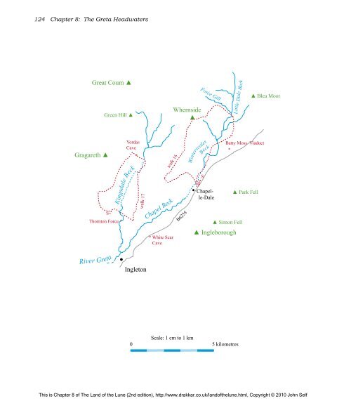
124 Chapter 8: <strong>The</strong> <strong>Greta</strong> <strong>Headwaters</strong> Gragareth ▲ Great Coum ▲ Green Hill ▲ S Thornton Force * • Yordas Cave * Kingsdale Beck walk 17 Ingleton Chapel Beck * White Scar Cave Whernside ▲ B6255 Force Gill Beck Winterscales • Chapelle-Dale Little Dale Beck ▲ Simon Fell ▲ Ingleborough Batty Moss Viaduct * River <strong>Greta</strong> ▲ Park Fell walk 16 Scale: 1 cm to 1 km 0 5 kilometres S ▲ Blea Moor This is Chapter 8 of <strong>The</strong> Land of the Lune (2nd edition), http://www.drakkar.co.uk/landofthelune.html, Copyright © 2010 John Self
<strong>The</strong> River <strong>Greta</strong> (Chapel Beck) ... <strong>The</strong> River <strong>Greta</strong> is formed at Ingleton by the confluence of the River Doe and River Twiss. Unfortunately, there is confusion as to which is which. <strong>The</strong> Ordnance Survey and the Ingleton Waterfalls Walk leaflet have the Doe to the east but Wainwright’s Walks in Limestone Country and Ingleton’s own leaflet have the Doe to the west. Upstream, the two rivers are called Chapel Beck (in Chapel-le-Dale) and Kingsdale Beck (in Kingsdale) and it seems simplest to retain those names down to the Ingleton junction, rather than choose between the river names. As Chapel Beck is the larger of the two at the junction I will consider that to provide the source of the <strong>Greta</strong>, with Kingsdale Beck being a tributary. This is supported by Thos Johnson’s 1872 book A Pictorial Handbook to the Valley of the Lune and Gossiping Guide to Morecambe and District (yes, really), which considers Chapel-le-Dale to lie in <strong>Greta</strong>dale. Moreover, he has a River Doe in Kingsdale, so if I were forced off the fence, I’d say the Ordnance Survey has it wrong. <strong>The</strong> source of Chapel Beck is at the head of Little Dale between Whernside and Blea Moor. Here, Little Dale Beck is joined by Force Gill, which has two fairsized waterfalls and crosses the Settle-Carlisle railway line over an aqueduct. Force Gill arises in Greensett, a boggy plateau on the eastern slopes of Whernside. Our obsession with getting to the tops of mountains – perhaps understandable with Whernside, as it is the highest peak of the Dales – tends to lead us to hurry past more interesting areas. Although the slopes of Whernside are now all CRoW land, 99% of walkers dutifully follow the signposted route, part of the Three Peaks walk, via Grain Head, ignoring Force Gill and Greensett. Actually, my preferred route up Whernside is from Kingsdale Head – all grass and no people (so forget I mentioned it). But the CRoW policy does raise a question: is it environmentally better that we all tread the standard path, thereby giving up that path to erosion and decay? Or should we spread ourselves thinly across CRoW land? <strong>The</strong>re seems little point in creating access land if we are not expected to access it but, on the other hand, even the occasional walker may be too much for some of the flora and fauna. <strong>The</strong> first time we walked the Three Peaks route we came across a curlew’s nest right by the path. <strong>The</strong>re’s no chance of that today. <strong>The</strong> curlew is the bird most <strong>The</strong> River <strong>Greta</strong> (Chapel Beck) ... 125 <strong>The</strong> Three Peaks are Whernside, Ingleborough and Peny-Ghent. <strong>The</strong> first two, at 736m and 724m, are the two highest peaks in the Yorkshire Dales and are wholly within Loyne. Pen-y-Ghent (694m) is the 7 th highest Dales peak and is in Ribblesdale. <strong>The</strong> Three Peaks walk of about 38km, with nearly 1600m of ascent, is a challenging all-day expedition. <strong>The</strong> Three Peaks fell race is even more challenging but should not take all day (only serious runners are allowed: no pantomime horses). <strong>The</strong> record is 2hr 46min for the present course and 2hr 29min for a previous course, with the ladies’ record standing at 3hr 13min. In 2008 the 54th Three Peaks race was run as the 5th World Long Distance Mountain Running Challenge. <strong>The</strong> start used to be at Chapel-le-Dale but is now at Horton-in-Ribblesdale, which has taken upon itself the role of Three Peaks centre. Of course, walkers may start at any point on the circuit. However, it is hardly a fell walk or race nowadays. Much of the route has been so badly eroded that the natural fell has been replaced. It is a shame that so many people (an estimated 250,000 a year) continue to follow such a worn path. Jack Sharp’s New Walks in the Yorkshire Dales provides a score of alternative long-distance walks. I would also suggest a Loyne Three Peaks – replace Pen-y-Ghent with Great Coum. <strong>The</strong> latter is only 7m lower and this route avoids the long trek over bog and on road from Pen-y-Ghent to Whernside and the eyesore of the Horton quarries (and it’s 10km shorter). redolent of the northern moors, with its distinctive call as it glides earthwards. Some describe it as plaintive or melancholy but it sounds bubblingly joyful to me. Never mind the swallow and cuckoo, it is the call of the curlew that is for me the most evocative of the new year (as early as January in 2006) as the curlew returns up the Lune valley to its nesting haunts. Below the red-tinged sandstone slopes of Whernside, grey slate tumbles towards the peat of Greensett Moss. Here is Greensett Tarn, the sheltered home of blackheaded gulls, and below the tarn is a line of shakeholes and caves, including Greensett Cave. <strong>The</strong>ir existence at 560m, when the main potholes and caves of the valley are at about 300m, shows that there is a layer of limestone here, as well as in the valley. Little Dale Beck absorbs Hare Gill and Foul Gutter from Blea Moor before crossing under the railway line, 1km north of the Ribblehead Viaduct, to become Two pages before: Ingleborough from Souther Scales. This is Chapter 8 of <strong>The</strong> Land of the Lune (2nd edition), http://www.drakkar.co.uk/landofthelune.html, Copyright © 2010 John Self