The Bristol-Mendip foreland thrust belt - Department of Earth Sciences
The Bristol-Mendip foreland thrust belt - Department of Earth Sciences
The Bristol-Mendip foreland thrust belt - Department of Earth Sciences

You also want an ePaper? Increase the reach of your titles
YUMPU automatically turns print PDFs into web optimized ePapers that Google loves.
Journal <strong>of</strong> the Geological Society, London, Vol. 143, 1986, pp. 63-73, 9 figs. Printed in Northern Ireland<br />
<strong>The</strong> <strong>Bristol</strong>-<strong>Mendip</strong> <strong>foreland</strong> <strong>thrust</strong> <strong>belt</strong><br />
G. D . WILLIAMS & T. J . C H A P M A N ’<br />
<strong>Department</strong> <strong>of</strong> Geology, University College, PO Box 78, Cardiff CF1 ZXL, U.K.<br />
<strong>Department</strong> <strong>of</strong> Geological <strong>Sciences</strong>, Plymouth Polytechnic, Drake Circus, Plymouth PL4 8AA, U. K.<br />
Abstract: <strong>The</strong> <strong>thrust</strong>s and associated fold structures <strong>of</strong> the <strong>Bristol</strong>-<strong>Mendip</strong> area are interpreted in<br />
terms <strong>of</strong> a thin skinned, piggy-back <strong>foreland</strong> <strong>thrust</strong> <strong>belt</strong> <strong>of</strong> Variscan age with dominant northward<br />
transport. Strike-normal balanced sections and compatible strike-parallel sections have been constructed<br />
to illustrate the 3-D geometry <strong>of</strong> the linked <strong>thrust</strong> system. North-south shortening <strong>of</strong> c.<br />
20 km (40%) is calculated from deformed and restored strike-normal sections. A thick and extensive<br />
<strong>thrust</strong> wedge <strong>of</strong> pre-Old Red Sandstone basement in the west <strong>of</strong> the area is responsible for<br />
culminations expressed at the surface as the <strong>Mendip</strong> periclines. Uplifted culminations permit erosion<br />
to lower stratigraphic levels in the west and south <strong>of</strong> the area. Strike-parallel sections and a hanging<br />
wall cut-<strong>of</strong>f map indicate that the majority <strong>of</strong> <strong>thrust</strong>s in the area are mainly oblique ramps rather than<br />
simple frontal and lateral ramps, or flats. <strong>The</strong> en-echelon pattern <strong>of</strong> the <strong>Mendip</strong> periclines may be<br />
related to the oblique NE climb <strong>of</strong> two <strong>of</strong> these <strong>thrust</strong>s. <strong>The</strong> angle <strong>of</strong> frontal ramp climb through the<br />
Dinantian stratigraphy is generally low, and this explains the presence <strong>of</strong> numerous klippen <strong>of</strong> Lower<br />
on Upper Carboniferous rocks, whilst suggesting that certain <strong>thrust</strong> sheets were much more extensive<br />
than present outcrops indicate. Early, pre-<strong>thrust</strong>ing movement on basement lineaments in the<br />
Variscan <strong>foreland</strong> created uplifts, angular unconformities and a predominance<br />
the north <strong>of</strong> the area.<br />
<strong>of</strong> N-S structures in<br />
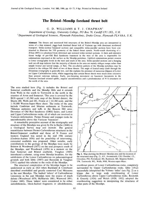
<strong>The</strong> area studied here (Fig. 1) includes the <strong>Bristol</strong> and<br />
Somerset coalfields and the <strong>Mendip</strong> Hills and it extends<br />
from Wells in the south to Tortworth in the north in the<br />
counties <strong>of</strong> Avon and Somerset. This area is covered by the<br />
BGS special 1 : 63,360 scale map <strong>of</strong> the <strong>Bristol</strong> district, the<br />
Sheets 280, Wells and 281, Frome at 1 : 63,360 scale, and the<br />
1 : 50,000 Weston-Super-Mare sheet. <strong>The</strong> rocks <strong>of</strong> the area<br />
include Cambrian and Silurian sediments at Tortworth;<br />
?Silurian andesites and tuffs in the Beacon Hill area;<br />
Devonian <strong>of</strong> Old Red Sandstone (ORS) facies; and Lower<br />
and Upper Carboniferous rocks: all <strong>of</strong> which are involved in<br />
Variscan deformation. Permo-Triassic and younger rocks lie<br />
unconformably above this Variscan ‘basement’.<br />
A remarkably perceptive account <strong>of</strong> the stratigraphy and<br />
structure <strong>of</strong> the <strong>Mendip</strong>s was given by De la Beche (1846) in<br />
Geological a Survey map and memoir. <strong>The</strong> general<br />
resemblance between Permo-Carboniferous structures in the<br />
<strong>Bristol</strong>/Somerset coalfield and those <strong>of</strong> N France and<br />
western England was noted in the mid 19th century<br />
(Godwin-Austen 1856) and the possibility <strong>of</strong> intervening,<br />
concealed coalfields was proposed. Other notable, early<br />
contributions to the geology <strong>of</strong> the <strong>Mendip</strong>s were made by<br />
Bristow & Woodward (1871) on the coal prospects south <strong>of</strong><br />
the <strong>Mendip</strong>s, and Woodward (1876) in a memoir on the<br />
East Somerset and <strong>Bristol</strong> coalfields. Vaughan (1905)<br />
introduced a scheme, using some <strong>Mendip</strong> localities, for the<br />
subdivision <strong>of</strong> the Lower Carboniferous on palaeontological<br />
grounds and both Sibly (1907) and Reynolds & Vaughan<br />
(1911) applied this scheme to the rocks <strong>of</strong> the <strong>Mendip</strong>s.<br />
<strong>The</strong> structural complexities <strong>of</strong> the <strong>Mendip</strong>s began to be<br />
understood as early as 1824 when Buckland & Conybeare<br />
described overfolded and greatly contorted Coal Measures<br />
in the east <strong>Mendip</strong>s. <strong>The</strong> faulted ‘inliers’ <strong>of</strong> Carboniferous<br />
Limestone in the east <strong>Mendip</strong>s were the source <strong>of</strong> much<br />
debate (Woodward 1876; McMurtrie 1881; Winwood 1891;<br />
Ussher 1889). <strong>The</strong>se ‘inliers’ were considered to be either<br />
autochthonous, block-faulted fragments or allochthonous,<br />
63<br />
-l<br />
BATH<br />
Fig. 1. Map showing the <strong>Bristol</strong>-<strong>Mendip</strong> area and the location <strong>of</strong><br />
the structural map (Fig. 2). AV, Avonmouth; CH, Cheddar; CL,<br />
Clevedon; PH, Portishead; RS, Radstock; SH, Shepton Mallet;<br />
TW, Tortworth; WL, Wells; WM, Weston-super-Mare.<br />
over<strong>thrust</strong> pieces <strong>of</strong> Lower Carboniferous rocks, completely<br />
surrounded by Upper Carboniferous rocks. Sibly (1912)<br />
successfully interpreted the Vobster ‘inlier’ (see Fig. 2) as a<br />
klippe due large to<br />
scale over<strong>thrust</strong>ing <strong>of</strong> Lower<br />
Carboniferous above Upper Carboniferous rocks. Reynolds<br />
& Greenly (1924) and Welch (1928, 1932) adopted the<br />
over<strong>thrust</strong>ing suggestion in interpreting the structures <strong>of</strong><br />
other parts <strong>of</strong> the <strong>Mendip</strong>s.
Fig. 2. Structural/lithostratigraphical map <strong>of</strong> the <strong>Bristol</strong>-<strong>Mendip</strong> area showing section lines A, B, C and D; major <strong>thrust</strong>s T1 to<br />
T3; and <strong>thrust</strong> zones T4 to T6. Klippen <strong>of</strong> Lower on Upper Carboniferous are labelled CK, Churchill; GK, Gordano; HK,<br />
Harptree; VK, Vobster and Upper Vobster. <strong>Mendip</strong> periclines are labelled BHP, Beacon Hill; BDP, Black Down; NHP, North<br />
Hill; PHP, Pen Hill. <strong>The</strong> ornament used for the various lithostratigraphic units is the same as on the cross-sections (Figs 6 , 7 and<br />
8).
More recent work has culminated in the publication <strong>of</strong><br />
BGS maps and associated memoirs (Green & Welch 1965;<br />
Whittaker & Green 1983). <strong>The</strong> crustal structure to the east<br />
<strong>of</strong> the <strong>Mendip</strong>s, based on deep seismic reflection pr<strong>of</strong>iles,<br />
has been elucidated by Chadwick et al. (1983) and<br />
re-evaluated by Williams & Brooks (1985). General<br />
accounts <strong>of</strong> the geology <strong>of</strong> the <strong>Bristol</strong>-<strong>Mendip</strong> area have<br />
been published by Kellaway & Welch (1948), Cave<br />
and Kellaway & Hancock (1983).<br />
(1963)<br />
In this paper, we use as a basis the abundance <strong>of</strong><br />
published structural information in the form <strong>of</strong> maps,<br />
cross-sections and mine and borehole data from the <strong>Mendip</strong><br />
area. <strong>The</strong>se, coupled with our own field observations, have<br />
enabled us to carry out detailed studies <strong>of</strong> individual <strong>thrust</strong><br />
faults and to elucidate the geometry <strong>of</strong> the <strong>Mendip</strong> <strong>thrust</strong><br />
system using balanced cross-sections. We present here a<br />
thin-skinned interpretation for the <strong>Mendip</strong> <strong>foreland</strong> <strong>thrust</strong><br />
<strong>belt</strong> and we discuss the evidence for such a geometry.<br />
Summary <strong>of</strong> stratigraphy<br />
<strong>The</strong> oldest exposed rocks in the <strong>Bristol</strong>-<strong>Mendip</strong> area are the<br />
Tremadocian shales <strong>of</strong> the Tortworth inlier (Curtis 1955)<br />
(Fig. 1). Also Tortworth, at mudstones, calcareous<br />
sandstones and limestones <strong>of</strong> Llandoverian and Wenlockian<br />
age are present. Presumed Silurian volcanic rocks occur in<br />
the core <strong>of</strong> the Beacon Hill pericline in the south <strong>of</strong> the<br />
<strong>Mendip</strong>s (Fig. 2 ) . <strong>The</strong> marine Silurian is overlain by a<br />
E<br />
0<br />
v)<br />
4 UPPER<br />
1<br />
d' I<br />
BELT BRISTOL-MENDIP<br />
THRUST FORELAND<br />
65<br />
COAL SERIES<br />
PENNANT SERIES<br />
QUARTZITIC SANDSTONE GROUP<br />
HOTWELLS LIMESTONE<br />
CLIFTON DOWN LIMESTONE<br />
BURRINGTON OOLITE<br />
I BLACK<br />
---I<br />
1<br />
7<br />
ROCK LIMESTONE<br />
LOWER LIMESTONE SHALE<br />
600 m-thick conformable sequence <strong>of</strong> Lower Devonian, Old<br />
Red Sandstone continental facies which is unconformably<br />
overlain by an Upper Devonian, Old Red Sandstone<br />
sequence varying in thickness from 500 m in the south to<br />
150 m in the north (Kellaway & Hancock 1983).<br />
Several significant non-sequences are present in the<br />
Dinantian succession <strong>of</strong> the <strong>Mendip</strong>s (Ramsbottom &<br />
Mitchell 1980), but the lithostratigraphy, based particularly<br />
on oolitic marker beds, can be correlated successfully from<br />
the <strong>Mendip</strong>s in the south to the Avon Gorge in the north<br />
(Whittaker & Green 1983). <strong>The</strong> total Dinantian sequence is<br />
approximately 800 m thick in the <strong>Bristol</strong> Coalfield (Kellaway<br />
& Hancock 1983). We have adopted the lithostratigraphic<br />
scheme <strong>of</strong> nomenclature involving Carboniferous units d' to<br />
d6 (Fig. 3) as portrayed on the <strong>Bristol</strong> District special sheet<br />
(1:63,360). This scheme, although outdated, proved to be<br />
more workable when cross referring fault cut-<strong>of</strong>fs <strong>of</strong><br />
stratigraphy, from maps to cross section, than either the<br />
biostratigraphy <strong>of</strong> Ramsbottom & Mitchell (1980) or the<br />
detailed lithostratigraphy <strong>of</strong> Whittaker & Green (1983). <strong>The</strong><br />
Dinantian is represented by various facies <strong>of</strong> Carboniferous<br />
Limestone deposited as platform or shelf type limestones (d'<br />
to d3 <strong>of</strong> the present scheme). In the northern part <strong>of</strong> the<br />
district, deposition was not continuous throughout the<br />
Carboniferous and it is probable that uplift and significant<br />
erosion took place along the NE-SW trending Lower<br />
Severn Axis in mid-Carboniferous times, prior to the<br />
deposition <strong>of</strong> the Upper Coal Measures (Kellaway & Welch<br />
1948; Whittaker & Green 1983). Evidence <strong>of</strong> this is the<br />
UPPER COAL MEASURES<br />
L. a M. COAL MEASURES<br />
MILLSTONE GRIT<br />
CARBONIFEROUS LIMESTONE DINANTIAN<br />
OLD SANDSTONE RED DEVONIAN<br />
WESTPHALIAN<br />
NAMURIAN-<br />
Fig. 3. Lithostratigraphic summary and nomenclature <strong>of</strong> rock units involved in the Variscan<br />
deformation.
66 G . D . W I L L I A M S & T. J . CHAPMAN<br />
major overstep <strong>of</strong> Upper Coal Measures (d6) on to Old Red<br />
Sandstone and Dinantian strata (Nat. Grid ref. 483734).<br />
Namurian and Westphalian (d4, d5 and d‘) rocks <strong>of</strong> the<br />
<strong>Bristol</strong> Coalfield attain a maximum thickness <strong>of</strong> 1900 m.<br />
Major Variscan deformation occurred towards the end <strong>of</strong><br />
the Carboniferous giving rise to northerly-verging, asymmetric<br />
folds and <strong>thrust</strong> faults. As Permo-Triassic and<br />
younger sediments serve only to blanket the Variscan<br />
terrane, they have not been studied nor are they shown on<br />
our maps and cross-sections.<br />
Structural synthesis<br />
<strong>The</strong> geology <strong>of</strong> the <strong>Mendip</strong>-<strong>Bristol</strong> area is dominated by the<br />
Variscan fold and <strong>thrust</strong> structures exposed through the<br />
Permian-Mesozoic cover (Fig. 2). Old Red Sandstone and<br />
older rocks are exposed in the extreme north <strong>of</strong> the area<br />
(including Silurian rocks <strong>of</strong> the Tortworth inlier), and at<br />
Portishead mainly in the core <strong>of</strong> an ENE-WSW trending<br />
anticline. the south, In notable outcrops <strong>of</strong> pre-<br />
Carboniferous rocks occur in the en-echelon, E-W trending<br />
<strong>Mendip</strong> periclines named from NW to SE the Blackdown,<br />
North Hill, Pen Hill and Beacon Hill periclines. Although<br />
periclinal in general form, these folds are asymmetric and<br />
northerly verging in N-S pr<strong>of</strong>ile with steep, southerlydipping<br />
axial surfaces. <strong>The</strong> E-W trend <strong>of</strong> structures in the<br />
south <strong>of</strong> the area changes to a NE-SW or N-S trend in the<br />
north.<br />
Thrust faults have been recognized for many years in the<br />
area and have been assigned a plethora <strong>of</strong> local names. We<br />
propose that many <strong>of</strong> these separately named <strong>thrust</strong>s are<br />
parts <strong>of</strong> single, laterally persistent structures. <strong>The</strong> isolated<br />
klippen <strong>of</strong> Carboniferous Limestone indicate large <strong>thrust</strong><br />
displacements and this supports our interpretation <strong>of</strong> large<br />
strike lengths for individual <strong>thrust</strong>s (Elliott 1976). We have<br />
assigned the symbols T, to T, to major <strong>thrust</strong>s <strong>of</strong> the area:<br />
the subscripts increase in the order <strong>of</strong> piggy-back <strong>thrust</strong><br />
development from hinterland to <strong>foreland</strong>. Thrusts T1, T,<br />
and probably T, are single laterally persistent structures,<br />
whereas T, to Ts are zones comprising several <strong>thrust</strong>s, which<br />
may join or branch, or may be separate with overlapping<br />
tips (see western part <strong>of</strong> T, on Fig. 2).<br />
Thrust T, (see Fig. 2) is a large E-W <strong>thrust</strong> passing close<br />
to Wells and Shepton Mallet. <strong>The</strong> klippen <strong>of</strong> Vobster,<br />
Upper Vobster and Luckington are underlain by <strong>thrust</strong> T,.<br />
Thrust T, stretches from Weston-Super-Mare in the west to<br />
the Radstock Coalfield in the east and it underlies the<br />
Churchill and Harptree klippen (local names: Bleadon<br />
Thrust, South-Western Over<strong>thrust</strong>, Emborough Thrust and<br />
Southern Over<strong>thrust</strong>). Thrust T3 corresponds the to<br />
Farmborough fault <strong>belt</strong> (Green & Welch 1965). Farther<br />
north (Fig. 2) a zone <strong>of</strong> <strong>thrust</strong>s, T,, extends from Clevedon<br />
on the coast to NE <strong>of</strong> <strong>Bristol</strong>. Local names include<br />
Clevedon, Naish House and Tickenham faults and this<br />
structure continues into the Kingswood Anticline east <strong>of</strong><br />
<strong>Bristol</strong>. Kellaway & Hancock (1983) termed this zone the<br />
Avon Thrust. <strong>The</strong> Gordano klippe is underlain by <strong>thrust</strong> T,.<br />
Thrust T, is a concealed NNE-SSW splay from T, and<br />
<strong>thrust</strong> T, is the NE-SW trending Ridgeway Thrust. Because<br />
<strong>of</strong> their orientation, it is likely that <strong>thrust</strong>s T5 and T, have<br />
undergone significant oblique-slip movement during Variscan<br />
shortening.<br />
<strong>The</strong> existence <strong>of</strong> various klippen related to three <strong>of</strong> the<br />
major <strong>thrust</strong>s helps to elucidate the 3-D geometry and<br />
tectonic history <strong>of</strong> the area. A strike-normal section across<br />
the Harptree klippe and North Hill Pericline (Fig. 3) shows<br />
steeply dipping to inverted Carboniferous Limestone (d’)<br />
<strong>thrust</strong> above Coal Measures (d’) on <strong>thrust</strong> T,. In a<br />
piggy-back <strong>thrust</strong>ing interpretation, this <strong>thrust</strong> has been<br />
folded above the North Hill Pericline, now eroded, but is<br />
preserved to the north in the core <strong>of</strong> a syncline. <strong>The</strong><br />
evolution <strong>of</strong> this structure (Fig. 4) involves movement on an<br />
early <strong>thrust</strong> (TJ which puts Dinantian on Westphalian<br />
strata. A subsequent, lower <strong>thrust</strong> creates the North Hill<br />
pericline as a tip line fold (Williams & Chapman 1983;<br />
Hossack 1983) responsible for folding <strong>of</strong> the overlying strata<br />
and the overlying <strong>thrust</strong> T,. It is clearly seen on both the<br />
<strong>Bristol</strong> and Wells 1:63,360 sheets that <strong>thrust</strong> T2, labelled<br />
‘South-Western Over<strong>thrust</strong>’ and ‘Emborough Thrust’ on<br />
those maps, is folded around the North Hill Pericline (Fig.<br />
2). This relationship, and those <strong>of</strong> other klippen,<br />
demonstrates the piggy-back nature <strong>of</strong> the <strong>thrust</strong> evolution.<br />
Lower and more northerly <strong>thrust</strong>s<br />
later than the folded upper <strong>thrust</strong>s.<br />
are clezrly developed<br />
Blind <strong>thrust</strong>s with frontal tips beneath the erosion level<br />
(Thompson 1981) are proposed for the generation <strong>of</strong> some<br />
<strong>of</strong> the periclines (e.g. North Hill Pericline, see Fig. 4).<br />
Lateral <strong>thrust</strong> tips may be seen elsewhere in the <strong>Mendip</strong>s<br />
indicating that not all <strong>thrust</strong>s are laterally persistent<br />
structures. On the north side <strong>of</strong> the North Hill Pericline<br />
(543526) the Miners Arms Thrust (Green<br />
emplaces Old Red Sandstone Carboniferous<br />
to on<br />
& Welch 1965)<br />
Limestone, omitting Lower Limestone Shales (d’”). To the<br />
west <strong>of</strong> the Stock Hill Fault (see the <strong>Bristol</strong> or Wells sheets)<br />
this <strong>thrust</strong> is not exposed and the Lower Limestone Shales<br />
are once more present, indicating a frontal tip (see Fig. 4).<br />
A similar structure exists (490525) in a small fault that splays<br />
from the South Western Over<strong>thrust</strong> (TJ. In a south-easterly<br />
direction along this <strong>thrust</strong> the stratigraphic separation<br />
decreases until at the tip there is no stratigraphic separation;<br />
the <strong>thrust</strong> terminates and a tip line fold is present (495523).<br />
A third example <strong>of</strong> a lateral <strong>thrust</strong> tip occurs on <strong>thrust</strong> T,,<br />
the Tickenham Fault (485728). Stratigraphic separation<br />
decreases in a north-easterly direction until it reaches zero<br />
at a tip line fold.<br />
Thrust faults across the whole <strong>Bristol</strong>-<strong>Mendip</strong> area can<br />
be observed in map view to cross-cut lithostratigraphy in<br />
both footwall and hangingwall along the exposed <strong>thrust</strong><br />
lengths, indicating the presence <strong>of</strong> lateral or oblique ramps<br />
rather than simple frontal ramps or<br />
reality, irregular <strong>thrust</strong> surfaces cross-cut sub-planar<br />
flats (Butler 1982). In<br />
lithostratigraphic interfaces to give a complex pattern <strong>of</strong><br />
hangingwall and footwall cut-<strong>of</strong>f lines. Using hangingwall<br />
stratigraphic cut <strong>of</strong>f points along <strong>thrust</strong> T,, the Dinantian<br />
stratigraphy preserved in the T, klippen, and the balanced<br />
cross-sections (Figs 6 & 7), we have constructed a<br />
hangingwall cut-<strong>of</strong>f line map (Fig. 5). In plan, cut-<strong>of</strong>f lines to<br />
the north <strong>of</strong> <strong>thrust</strong> T, are now eroded and those to the south<br />
<strong>of</strong> this <strong>thrust</strong> are buried. Assuming initially sub-planar<br />
stratigraphic interfaces, the observed irregularities in the<br />
cut-<strong>of</strong>f lines reflect the presence <strong>of</strong> a large-scale oblique<br />
ramp which becomes gradually frontal in the west <strong>of</strong> the<br />
area. On this structure is superimposed a smaller scale<br />
culmination above the North Hill Pericline, defined by<br />
frontal and oblique ramps. <strong>The</strong> hangingwall cut-<strong>of</strong>f map<br />
(Fig. 5) has been used to estimate the angle <strong>of</strong> ramp climb<br />
through the Dinantian stratigraphy.
B R I S T O L - M E N D I P F O R E L A N D T H R U S T B E L T 67<br />
ORS<br />
---_<br />
NORTH 1<br />
NlVER EAKER HILL PEN HILL<br />
_ c<br />
5 km<br />
Fig. 4. Evolutionary diagram to explain the piggy-back nature <strong>of</strong> the North Hill Pericline<br />
(NHP) and the East Harptree klippe (EHK). V = H scale.<br />
Fig. 5. Stratigraphic cut-<strong>of</strong>f map for the hangingwall <strong>of</strong> <strong>thrust</strong> T2. Buried cut-<strong>of</strong>fs occur to the south and eroded<br />
cut-<strong>of</strong>fs to the north <strong>of</strong> the main outcrop <strong>of</strong> <strong>thrust</strong> T2. Dark stipple, Old Red Sandstone; clear, Carboniferous<br />
Limestone (including Millstone Grit); light stipple, Coal Measures. BDP, Black Down Pericline; NHP, North Hill<br />
Pericline, PHP, Pen Hill Pericline.<br />
I
68 G . D . WILLIAMS & T. J. C H A P M A N<br />
Strike-normal cross-sections<br />
1.1 km. A comparison <strong>of</strong> the two sections A and B (Figs 6 &<br />
Two approximately north-south balanced cross-sections, A<br />
and B, have been constructed (section lines on Fig. 2) with<br />
the relevant displacement-distance diagrams (Chapman &<br />
Williams 1984) (Figs 6 & 7). <strong>The</strong> hangingwall cut-<strong>of</strong>f map<br />
(Fig. 5) indicates that <strong>thrust</strong> T, cuts up section northwards<br />
through the stratigraphy at a maximum angle <strong>of</strong> 22" in the<br />
east <strong>of</strong> the area and a minimum <strong>of</strong> 6" in the west. <strong>The</strong> angle<br />
measurtd is that between stratigraphic interfaces in the<br />
hangingwall and <strong>thrust</strong> surface T, on the strike-normal<br />
sections. This implies a thin skinned geometry for the <strong>thrust</strong><br />
system. <strong>The</strong> amplitude <strong>of</strong> major asymmetric folds and the<br />
sheet dip or fold envelope dip can be estimated from surface<br />
dip data. <strong>The</strong> sheet dip defines the angle <strong>of</strong> dip <strong>of</strong> the basal<br />
<strong>thrust</strong> fault, and the amplitude <strong>of</strong> major folds dictates the<br />
thickness <strong>of</strong> sub Old Red Sandstone rocks involved in the<br />
linked-<strong>thrust</strong> system on area balance arguments. Using these<br />
criteria, the minimum depth to the basal <strong>thrust</strong> is estimated<br />
to vary from 3 to 5 km and is displayed on Figs 6 and 7.<br />
<strong>The</strong> western section, A (Fig. 6) shows that <strong>thrust</strong> T, cuts<br />
7) shows a thicker basement in the <strong>thrust</strong> sheets in the west.<br />
In the east, the Coal Measures <strong>of</strong> the <strong>Bristol</strong> and Somerset<br />
Coalfields are exposed above a dkcollement involving only a<br />
thin basement wedge. <strong>The</strong> depth to dCcollement across the<br />
south <strong>of</strong> the area is consistent at 4.9 km and in the north it is<br />
at a depth <strong>of</strong> 3.1 km representing a basal <strong>thrust</strong> presently<br />
dipping south at 3". Section B (Fig. 7) has undergone a total<br />
shortening <strong>of</strong> 27 km (38%) using the hangingwall cut-<strong>of</strong>f <strong>of</strong><br />
base ORS by T, as a datum.<br />
In both footwall and hangingwall, <strong>thrust</strong>s T, and T, are<br />
at a higher stratigraphic level in the east (Fig. 6) than the<br />
west (Fig. 7). This observation is supported by the T2<br />
hangingwall cut-<strong>of</strong>f diagram (Fig. 5) which illustrates<br />
oblique ramp climb in a north-easterly direction. In reality<br />
both T, and T3 are oblique hangingwall and footwall ramps,<br />
climbing stratigraphy towards the NE and it is possible that<br />
the en-echelon nature <strong>of</strong> the <strong>Mendip</strong> periclines may be, in<br />
part, related to these <strong>thrust</strong>s.<br />
up stratigraphy in the transport direction at a very shallow<br />
angle. It is folded by the Blackdown Pericline and an<br />
Strike-parallel cross-sections<br />
associated syncline at Blackdown has subsequently been<br />
eroded. This syncline plunges westwards and preserves d3<br />
Two strike-parallel cross sections C & D (Fig. 8) have been<br />
constructed, as viewed southwards against the <strong>thrust</strong><br />
limestone in the Churchill klippe to the west <strong>of</strong> section line movement direction. Major <strong>thrust</strong>s T1 to T4 are labelled,<br />
A. <strong>The</strong> shallow angle <strong>of</strong> T, ramp climb means that <strong>thrust</strong> and it may be noted that older rocks are consistently<br />
sheet T, once extended significantly farther north than displaced above younger rocks.<br />
suggested by the present outcrop map. Thrust T3 is Section C (Fig. 8) illustrates a greater thickness <strong>of</strong> Lower<br />
responsible for the generation <strong>of</strong> the Blackdown Pericline Palaeozoic basement in the west and the corresponding<br />
and it possibly joins T, which forms a ro<strong>of</strong> <strong>thrust</strong>. <strong>The</strong> Avon preservation <strong>of</strong> higher Carboniferous stratigraphy in the<br />
Thrust, T4, and those to the north represent only minor east. Thrusts T, and T, exhibit numerous footwall and<br />
displacements. <strong>The</strong> structural complexity at Portishead is hangingwall stratigraphic cut-<strong>of</strong>fs and this corroborates their<br />
due to pre-Pennant Measures (d6) folding and erosion. <strong>The</strong> interpretation as lateral or oblique ramps. A sequential<br />
unconformable relationship <strong>of</strong> d6 to folded lower units may diagram (Fig. 9) illustrates how different hangingwall and<br />
be seen on the restored section. Using the amplitude <strong>of</strong> footwall stratigraphies were juxtaposed along <strong>thrust</strong> T,. In a<br />
major folds such as the Blackdown Pericline, it appears that layer-cake stratigraphy, the <strong>thrust</strong> trajectory will be<br />
the thickness <strong>of</strong> pre-ORS basement above the basal <strong>thrust</strong> irregular if the <strong>thrust</strong> cuts up and down stratigraphy laterally<br />
varies from 1.2 km in the north to 2.2 km in the south. <strong>The</strong> (Fig. sa). <strong>The</strong> irregularly truncated hangingwall stratigraphy<br />
hangingwall cut-<strong>of</strong>f <strong>of</strong> base ORS by <strong>thrust</strong> T2 may be used as will be transported in a <strong>foreland</strong> direction and may be<br />
a datum point to calculate a total shortening <strong>of</strong> 19 km (38%) emplaced on an irregular footwall (Fig. 9b). Internal<br />
for this section. Displacement-distance diagrams (Chapman hangingwall strain will take the form <strong>of</strong> culminations and<br />
& Williams 1984) shown in Figs 6 & 7 record shortening depressions. Because a <strong>thrust</strong> will cut up stratigraphy in a<br />
only to the north, and in the footwall, <strong>of</strong> <strong>thrust</strong> T,. This <strong>foreland</strong> direction, older rocks will be placed on younger<br />
accounts for only approximately 20% shortening in both rocks (Fig. 9c). Further folding <strong>of</strong> both hangingwall and<br />
cross-sections A and B (Figs 6 & 7), and this serves to footwall, plus the intervening <strong>thrust</strong> fault T2 has been caused<br />
illustrate the magnitude <strong>of</strong> displacement on <strong>thrust</strong> T,. by movement on a lower <strong>thrust</strong> T, and a splay from T3, the<br />
Back<strong>thrust</strong>s south <strong>of</strong> Nailsea propagate from <strong>thrust</strong> T4 and Miners Arms Thrust (Fig. 9d). Thrust T3 cuts down section<br />
are responsible for small displacements which back rotate laterally, incorporating lower stratigraphy into the <strong>thrust</strong><br />
and steepen <strong>thrust</strong> T,. Cross sections on the 1 : 63,360 <strong>Bristol</strong> sheet in a westerly direction. This has generated a major<br />
sheet show these faults as steep S-dipping normal faults. <strong>The</strong> N-S trending culmination which serves to fold the overlying<br />
outcrop pattern <strong>of</strong> the Brockley Fault (470680) indicates a <strong>thrust</strong> T,. This culmination is the North Hill Pericline. <strong>The</strong><br />
northerly dip and supports its interpretation as a back<strong>thrust</strong>. general oblique NE climb <strong>of</strong> T, in its hangingwall is<br />
<strong>The</strong> eastern section, B (Fig. 7) shows that <strong>thrust</strong> T2 cuts responsible for the en-echelon pattern <strong>of</strong> the Black Down<br />
up section rapidly in the movement direction. It is folded and North Hill periclines.<br />
above the Beacon Hill Pericline, and the small syncline to Section D (Fig. 8) shows thick a wedge <strong>of</strong> Lower<br />
the north <strong>of</strong> Beacon Hill when projected eastwards is Palaeozoic rocks above the basal <strong>thrust</strong> in the west, and the<br />
responsible for the preservation <strong>of</strong> the Luckington, Vobster basal detachment within ORS to the east. In the east <strong>of</strong> this<br />
and Upper Vobster klippen. This section differs from A in section the N-S trending Coalpit Heath basin is seen to be<br />
that there is only a thin wedge <strong>of</strong> pre-ORS basement above underlain by the proposed extension <strong>of</strong> the Malvern fault<br />
the basal detachment and this wedge thins to zero beneath line. To the east <strong>of</strong> this, the ORS thins dramatically, and is<br />
the Radstock Coalfield (points R and R' on deformed and<br />
restored sections). To the north <strong>of</strong> point R, the basal <strong>thrust</strong><br />
underlain by Lower Palaeozoic basement. As with Section<br />
C, the existence <strong>of</strong> Lower Palaeozoic rocks above a planar<br />
fault is within the Old Red Sandstone sequence. <strong>The</strong><br />
basal <strong>thrust</strong> controls the present erosion level <strong>of</strong> <strong>thrust</strong><br />
maximum thickness <strong>of</strong> basement in the south <strong>of</strong> section B is culminations and depressions.
I<br />
c<br />
5<br />
0<br />
I<br />
c<br />
K<br />
0<br />
z a<br />
r<br />
n<br />
r----<br />
I<br />
I<br />
I<br />
I<br />
I<br />
I<br />
I<br />
I<br />
I<br />
I<br />
I<br />
I<br />
I<br />
I<br />
I<br />
-f<br />
n<br />
r<br />
I<br />
I<br />
I<br />
I<br />
I<br />
l<br />
I<br />
.f<br />
f<br />
I<br />
I<br />
f<br />
t-<br />
f<br />
t<br />
-
70<br />
G . D . WILLIAMS & T . J. C H A P M A N<br />
. I F-----<br />
I’ I
EAST<br />
BRISTOL-MENDIP FORELAND THRUST BELT 71<br />
5 ~~ km<br />
l 1<br />
C SECT. B SECT.A Cl<br />
I<br />
-<br />
SECT. C<br />
Fig. 8. Strike-parallel cross sections (C & D) across the <strong>Bristol</strong>-<strong>Mendip</strong> area. See Fig. 2 for the location <strong>of</strong> sections<br />
Vertical = horizontal scale.<br />
EAST WEST<br />
-<br />
Hangingwall<br />
- -- -_<br />
Discussion<br />
T 2<br />
We propose that the <strong>Mendip</strong>-<strong>Bristol</strong> area represents a thin<br />
-33<br />
d2<br />
ORS'' d l 7!.!.!.1.!.! ..:. ................... I ! .--<br />
.... : ...... . :, . ~ .............................................<br />
. . .........,.....,............<br />
. . . . . , . . . . m<br />
. ~ . . . . .<br />
skinned <strong>foreland</strong> <strong>thrust</strong> <strong>belt</strong> <strong>of</strong> Variscan age. <strong>The</strong> dominant<br />
direction <strong>of</strong> <strong>thrust</strong> movement was south to north. Our<br />
interpretation is based on surface lithostratigraphic and<br />
T--_-- 2<br />
structural observations, plus mine and borehole information<br />
-_ Footwall . (see <strong>Bristol</strong> sheet) from which the balanced cross sections<br />
'. - -<br />
(Figs 6 & 7) were constructed. Evidence for the thin skinned<br />
/--<br />
...............................<br />
I I I I I I I I I I I I I ...-. I I I. . I . I . ) . . ~ . ~ . . I . I. . I . I . . ~ . I...... . I ~ I I I ~ ~ , ~ ~ I<br />
. . ;*.: . . . . . S . . . . . . . . .... . . . ............... . . .,.: :. .......... ,a,: . . . .:.. ::.I: ',: .. :. ..... :: 1 ................ nature <strong>of</strong> the <strong>belt</strong> is provided by the existence <strong>of</strong><br />
. . . . . . .<br />
far-travelled klippen (e.g. Upper Vobster, Churchill). A<br />
combination <strong>of</strong> hangingwall cut-<strong>of</strong>f points and the preserved<br />
stratigraphy in certain klippen have enabled the construction<br />
<strong>of</strong> a hangingwall cut-<strong>of</strong>f map (Fig. 5 ) for <strong>thrust</strong> T2. By<br />
combining stratigraphic information with the position <strong>of</strong><br />
cut-<strong>of</strong>f lines, calculated angles <strong>of</strong> frontal ramp climb<br />
between 6" and 22" support the thin skinned interpretation.<br />
Further support for this suggestion is obtained from the<br />
sheet dip <strong>of</strong> the Lower Carboniferous rocks. We have<br />
assumed that the basal <strong>thrust</strong> is subparallel to this sheet dip<br />
in strike-normal sections. In similar forland <strong>thrust</strong> <strong>belt</strong>s such<br />
as the Appalachians (Gwinn 1964; Rodgers 1970) and the<br />
Rockies (Price 1981) both <strong>of</strong> which are well constrained by<br />
seismic data, the relationship between sheet dip and basal<br />
detachment is confirmed. Our interpretation <strong>of</strong> the Variscan<br />
structure <strong>of</strong> the area differs markedly however from that<br />
Fig. 9. Hangingwall sequence diagram for <strong>thrust</strong> T2 and the<br />
generation <strong>of</strong> the culmination beneath it, as viewed southwards<br />
parallel to <strong>thrust</strong> movement direction. (a) preserved hangingwall<br />
stratigraphy, (b) footwall stratigraphy, (c) juxtaposition <strong>of</strong> two<br />
stratigraphies, and (d) generation <strong>of</strong> the culmination and folding <strong>of</strong><br />
given by Kellaway & Hancock (1983) who proposed a<br />
folded dkcollement in Silurian sandstone and ?hale beneath<br />
the Somerset and <strong>Bristol</strong> coalfields. Also, rather than<br />
piggy-back <strong>thrust</strong>ing with folded upper <strong>thrust</strong>s, Kellaway &<br />
Hancock (1983) proposed lag faults for the numerous<br />
<strong>thrust</strong> K?.<br />
klippep in the <strong>Mendip</strong>s.<br />
WEST
72 G . D . WILLIAMS & T. J . CHAPMAN<br />
the Somerset and <strong>Bristol</strong> coalfields. Also, rather than<br />
piggy-back <strong>thrust</strong>ing with folded upper <strong>thrust</strong>s, Kellaway &<br />
Hancock (1983) proposed lag faults for the numerous<br />
klippen in the <strong>Mendip</strong>s.<br />
<strong>The</strong> incorporation <strong>of</strong> Lower Palaeozoic basement wedges<br />
into <strong>thrust</strong> sheets satisfies area balancing constraints. <strong>The</strong><br />
thickness <strong>of</strong> Lower Palaeozoic basement in the <strong>thrust</strong> sheets<br />
calculated from observations <strong>of</strong> major fold amplitudes in<br />
strike-normal sections reduces from south to north in<br />
strike-normal sections and from west to east in strikeparallel<br />
sections. <strong>The</strong> eastward decrease in basement<br />
thickness explains why Lower Carboniferous and ORS<br />
strata are exposed in the west and Upper Carboniferous in<br />
the east. <strong>The</strong> <strong>Mendip</strong> periclines are asymmetric and verge<br />
northwards, and their periclinal nature is due to <strong>thrust</strong><br />
culminations involving basement at depth. <strong>The</strong>ir overall<br />
en-echelon pattern may be related to the oblique climb <strong>of</strong><br />
two major <strong>thrust</strong>s (T2 and T3) towards the NE, and climb <strong>of</strong><br />
the basal detachment eastwards. <strong>The</strong> majority <strong>of</strong> exposed<br />
<strong>thrust</strong>s are oblique hangingwall and footwall ramps.<br />
Deformation which took place earlier than the Variscan<br />
<strong>thrust</strong>ing, is observed in the north <strong>of</strong> the area where Upper<br />
Carboniferous Pennant Measures unconformably overlie<br />
previously folded Lower Carboniferous and ORS rocks,<br />
notably along the Lower Severn Axis. Such structures may<br />
be related to major lineaments such as the Malvern Fault<br />
Zone (Kellaway & Hancock 1983) or lesser faults such as<br />
the ‘disturbances’ observed on the north crop <strong>of</strong> the South<br />
Wales Coalfield (Owen 1971, 1983). <strong>The</strong> north-south<br />
trending Coalpit Heath basin and Tortworth inlier are<br />
almost certainly related to major pre-Variscan basement<br />
lineaments. In terms <strong>of</strong> Variscan evolution it is possible that<br />
whilst deformation was beginning in southern Cornwall and<br />
Devon, in late Devonian to early Carboniferous times<br />
(Dearman 1971), basement lineaments crossing the Variscan<br />
<strong>foreland</strong> were activated as sinistral strike-slip faults giving<br />
localized <strong>belt</strong>s <strong>of</strong> deformation, and localized uplift and<br />
subsidence. Piggy-back <strong>thrust</strong>ing migrated northwards<br />
(Shackleton et al. 1982; Coward & Smallwood 1984) and by<br />
latest Carboniferous times the locus <strong>of</strong> <strong>thrust</strong>ing was in the<br />
<strong>Mendip</strong> area. <strong>The</strong> later, thin skinned <strong>thrust</strong>s cut across and<br />
detached the early basement faults incorporating them into<br />
the <strong>thrust</strong> sheets. <strong>The</strong> strike <strong>of</strong> <strong>thrust</strong>s T, and T, in the north<br />
<strong>of</strong> the area may well be controlled by earlier, deeper faults<br />
and they have probably undergone both strike-slip and<br />
<strong>thrust</strong> displacements. <strong>The</strong> Variscan ‘front’ is a diffuse zone<br />
in which <strong>thrust</strong>-type deformation dies out. It is likely to be<br />
represented by a blind <strong>thrust</strong> that exists significantly farther<br />
north than the previously suggested position <strong>of</strong> the Variscan<br />
front (Hancock et al. 1983; Chadwick et al. 1984; Shackleton<br />
1984). <strong>The</strong> possibility exists that early basement-controlled<br />
structures such as the Usk and Tortworth inliers, and the<br />
Forest <strong>of</strong> Dean syncline are all underlain by the northward<br />
extension <strong>of</strong> the basal <strong>thrust</strong> represented on<br />
C and D (Figs 6, 7 & 8).<br />
sections A , B,<br />
We would like to thank Paul Hancock for valuable discussion and<br />
our colleagues at Cardiff and Plymouth for the same. Thanks are<br />
also due to G. A. Kellaway for comments on the detailed geology<br />
<strong>of</strong> the <strong>Bristol</strong>-<strong>Mendip</strong> area and to Mark Cooper and Ge<strong>of</strong>f Tanner<br />
for critical reviews <strong>of</strong> the manuscript. This paper is dedicated to the<br />
innumerable undergraduates who have ‘done’ the <strong>Bristol</strong> sheet.<br />
References<br />
BRISTOW, H. W. & WOODWARD, H. B. 1871. Remarks on the prospects <strong>of</strong><br />
coal to the south <strong>of</strong> the <strong>Mendip</strong>s. Geological Magazine, 8, 500-5.<br />
BUCKLAND, W. & CONYBEARE, W. D. 1924. Observations on the<br />
South-Western coal district <strong>of</strong> England. Tramactions <strong>of</strong> the Geological<br />
Society <strong>of</strong> London, Series 2, 1, 210.<br />
BUTLER, R. W .H. 1982. <strong>The</strong> terminology <strong>of</strong> structures in <strong>thrust</strong> <strong>belt</strong>s. Journal<br />
<strong>of</strong> Structural Geology, 4, 239-46.<br />
CAVE, R. 1963. <strong>Bristol</strong> and South Wales District. Summary Programme <strong>of</strong> the<br />
Geological Survey, United Kingdom, 38-9.<br />
CHADWICK, R. A., KENOLTY, N. & WHITTAKER, A. 1983. Crustal structure<br />
beneath southern England from deep seismic reflection pr<strong>of</strong>iles. Journal<br />
<strong>of</strong> the Geological Society, London, 140, 893-911.<br />
CHAPMAN, T. 5. & WILLIAMS, G. D. 1984. Displacement-distance methods in<br />
the analysis <strong>of</strong> fold-<strong>thrust</strong> structures and linked fault systems. Journal <strong>of</strong><br />
the Geological Society, London, 141, 121-8.<br />
COWARD, M. P. & SMALLWOOD, S. 1984. An interpretation <strong>of</strong> Variscan<br />
tectonics <strong>of</strong> SW England. Special Publication <strong>of</strong> the Geological Society,<br />
London, 14, 89-102.<br />
CURTIS, M. L. K. 1955. Geology: Lower Palaeozoic: In: MACINNES, C. M. &<br />
WHITTARD, W. S. (eds) <strong>Bristol</strong> and its Adjoining Counties. British<br />
Association for the Advancement <strong>of</strong> Science, <strong>Bristol</strong>, 3-9.<br />
DEARMAN, W. R. 1971. A general view <strong>of</strong> the structure <strong>of</strong> Cornubia.<br />
Proceedings <strong>of</strong> the Ussher Society, 2, 221-36.<br />
DE LA BECHE, H. T. 1846. On the formations <strong>of</strong> rocks <strong>of</strong> S. Wales and S.W.<br />
England. Memoirs <strong>of</strong> the Geological Survey <strong>of</strong> Great Britain.<br />
ELLIOIT, D. 1976. <strong>The</strong> energy balance and deformation mechanisms <strong>of</strong> <strong>thrust</strong><br />
sheets. Philosophical Transactions <strong>of</strong> the Royal Society <strong>of</strong> London,<br />
A.283,289-312.<br />
- & JOHNSON, M. R. W. 1980. Structural evolution in the northern part <strong>of</strong><br />
the Moine Thrust Zone. Transactions <strong>of</strong> the Royal Society <strong>of</strong> Edinburgh<br />
<strong>Earth</strong> <strong>Sciences</strong>, 71, 69-96.<br />
GODWIN-AUSTEN, R. A. C. 1856. On the possible extension <strong>of</strong> the Coal<br />
Measures beneath the southern part <strong>of</strong> England. Quarterly Journal <strong>of</strong> the<br />
Geological Society <strong>of</strong> London, U, 38-46.<br />
GREEN, G. W. & WELCH, F. B. A. 1965. Geology <strong>of</strong> the country around<br />
Wells and Cheddar. Memoirs <strong>of</strong> the Geological Survey <strong>of</strong> the United<br />
Kingdom.<br />
GWINN, U. E. 1964. Thin-skinned tectonics in the Plateau and northwestern<br />
Valley and Ridge provinces <strong>of</strong> the Central Appalachians. Bulletin <strong>of</strong> the<br />
Geological Society <strong>of</strong> America, 75, 863-900.<br />
HANCOCK, P. L., DUUNE, W. M. & TINGHAM, M. E. 1983. Variscan<br />
deformation in Southwest Wales. In: HANCOCK, P. L. (ed.) <strong>The</strong> Variscan<br />
Fold Belt in the British Isles. Adam Hilger Ltd., <strong>Bristol</strong> 47-73.<br />
HOSSACK, J. R. 1983. A cross-section through the Scandinavian Caledonides<br />
constructed with the aid <strong>of</strong> branch line maps. Journal <strong>of</strong> Structural<br />
Geology, 5, 103-11.<br />
KELLAWAY, G. A. & WELCH, F. B. A. 1948. <strong>Bristol</strong> and Gloucester district.<br />
British Regional Geology HMSO, London.<br />
- & HANCOCK, P. L. 1983. Structure <strong>of</strong> the <strong>Bristol</strong> district, the Forest <strong>of</strong><br />
Dean and the Malvern fault zone. In: HANCOCK, P. L. (ed.) <strong>The</strong> Variscan<br />
Fold Belt in the British Isles. Adam Hilger Ltd., <strong>Bristol</strong>. 88-107.<br />
MCMURTIE, J. 1881. <strong>The</strong> Somersetshire coalfield and method <strong>of</strong> working thin<br />
seams in the Radstock district. Proceedings <strong>of</strong> the South Wales Institute <strong>of</strong><br />
Engineers, 12.<br />
OWN, T. R. 1971. <strong>The</strong> structural evolution <strong>of</strong> the <strong>Bristol</strong> Channel.<br />
Proceedings <strong>of</strong> the Geological Society, London, 1664, 289-93.<br />
- & WEAVER, J. D. 1983. <strong>The</strong> structure <strong>of</strong> the main South Wales coalfield<br />
and its margins. In: HANCOCK, L. P. (ed.) <strong>The</strong> Variscan Fold Belt in the<br />
British Isles. Adam Hilger Ltd., <strong>Bristol</strong>. 74-87.<br />
PRICE, R. A. 1980. <strong>The</strong> Cordilleran <strong>foreland</strong> <strong>thrust</strong> <strong>belt</strong> in the southern<br />
Canadian Rocky Mountains. In: MCCLAY, K. R. & PRICE, N. J. (eds)<br />
Thrust and Nappe Tectonics. Special Publication <strong>of</strong> the Geological<br />
Society, London, 9, 418-27.<br />
RAMSBOTTOM, W. H. L. & MITCHELL, M. 1980. <strong>The</strong> recognition and division<br />
<strong>of</strong> the Tournaisian Series in Britain. Journal <strong>of</strong> the Geological Society,<br />
London, W7, 61-3.<br />
REYNOLDS, S. H. & GREENLY, E. 1924. <strong>The</strong> geological structure <strong>of</strong> the<br />
Clevedon-Portishead ridge. Quarterly Journal <strong>of</strong> the Geological Sociery<br />
<strong>of</strong> London, 80, 447-67.<br />
- & VAUGHAN, A. 1911. Fauna1 and lithological sequences in the<br />
Carboniferous Limestone Series <strong>of</strong> Burrington Combe, Somerset.<br />
Quarterly Journal <strong>of</strong> the Geological Society <strong>of</strong> London, 67, 342-92.<br />
RODGERS, J . 1970. <strong>The</strong> Tectonics <strong>of</strong> the Appalachians. Wiley-Interscience,<br />
New York.<br />
SHACKLETON, R. M. 1984. Thin skinned tectonics, basement control and the<br />
Variscan front. In: HUTTON, D. H. W. & SANDERSON, D. J. (eds)<br />
Variscan Tectonics <strong>of</strong> the North Atlantic Region. Special Publication <strong>of</strong>
the Geological Society, London, 14, 125-9.<br />
~ & RIES, A. C. & COWARD, M. P. 1982. An interpretation <strong>of</strong> the<br />
Variscan structures in S.W. England. Journal <strong>of</strong> the Geological Society,<br />
London, 139, 533-4.<br />
SIBLY, T. F. 1907. On the Carboniferous limestone <strong>of</strong> Burrington Combe.<br />
Proceedings <strong>of</strong> the British Nature Society, 1, 14-41,<br />
- 1912. <strong>The</strong> faulted inlier <strong>of</strong> Carboniferous limestone at Upper Vobster,<br />
(Somerset). Quarterly Journal <strong>of</strong> the Geological Society <strong>of</strong> London, 68,<br />
58-74.<br />
THOMPSON, R. I . 1980. <strong>The</strong> nature and significance <strong>of</strong> large blind <strong>thrust</strong>s<br />
within the northern Rocky Mountains <strong>of</strong> Canada. In: MACCLAY, K. R. &<br />
PRICE, N. J. (eds) Thrwt and Nappe Tectonics. Special Publication <strong>of</strong> the<br />
Geological Society, London, 9, 449-62.<br />
USHER, W. A. E. 1889. Some points <strong>of</strong> interest in the geology <strong>of</strong> Somerset.<br />
Reprint <strong>of</strong> the Brit&-h Association (Bath), 659.<br />
VAUGHAN, A. 1905. <strong>The</strong> palaeontological sequence in the Carboniferous<br />
Limestone <strong>of</strong> the <strong>Bristol</strong> area. Quarterly Journal <strong>of</strong> the Geological Society<br />
<strong>of</strong> London, 61, 181-307.<br />
BRISTOL-MENDIP<br />
THRUST FORELAND<br />
BELT 73<br />
Received 28 May 1985<br />
WELCH, F. B. A. 1928. <strong>The</strong> geological structure <strong>of</strong> the central <strong>Mendip</strong>s.<br />
Quarterly Journal <strong>of</strong> the Geological Society <strong>of</strong> London, 85, 45-76.<br />
- 1932. <strong>The</strong> geological structure <strong>of</strong> the eastern <strong>Mendip</strong>s. Quarterly Journal<br />
<strong>of</strong> the Geological Society <strong>of</strong> London, 89, 14-49.<br />
WHITTAKER, A. & GREEN, G. W. 1983. Geology <strong>of</strong> the country around<br />
Weston-Super-Mare. Memoirs <strong>of</strong> the Geological Survey <strong>of</strong> the United<br />
Kingdom.<br />
WILLIAMS, G. D. & BROOKS, M. 1985. A reinterpretation <strong>of</strong> the concealed<br />
Variscan structure beneath Southern England by section balancing.<br />
Journal <strong>of</strong> the Geological Society, London, 142, 689-95.<br />
- & CHAPMAN, T. J. 1983. Strains in the hangingwalls <strong>of</strong> <strong>thrust</strong>s due to<br />
their slip/propagation rate: a dislocation model. Journal <strong>of</strong> Structural<br />
Geology, 5, 563-71.<br />
WINWOOD, H. H. 1891. A Rhaetic section at Luckington and additional notes<br />
on the Vobster Quarry. Proceedings <strong>of</strong> the Bath Natural History Society,<br />
7, 45-9.<br />
WOODWARD, H. B. 1876. <strong>The</strong> east Somerset and <strong>Bristol</strong> Coalfields. Memoirs<br />
<strong>of</strong> the Geological Survey <strong>of</strong> the United Kingdom.