Southwest Desert Campsites - National Park Service
Southwest Desert Campsites - National Park Service
Southwest Desert Campsites - National Park Service

Create successful ePaper yourself
Turn your PDF publications into a flip-book with our unique Google optimized e-Paper software.
<strong>Southwest</strong> <strong>Desert</strong><br />
<strong>Campsites</strong><br />
To Virgin<br />
Coalpits<br />
Spring<br />
Coalpits Wash<br />
6<br />
Coalpits Wash<br />
5<br />
4<br />
Coalpits Wash<br />
3<br />
Scoggins Wash<br />
Scoggins Wash<br />
Stock Trail<br />
1<br />
2<br />
Huber Wash<br />
0 0.5<br />
1 2<br />
Miles<br />
Rockville<br />
Zion<br />
Virgin River<br />
<strong>National</strong> <strong>Park</strong> <strong>Service</strong><br />
U.S. Department of the Interior<br />
Zion <strong>National</strong> <strong>Park</strong><br />
April 2009<br />
<strong>National</strong><br />
<strong>Park</strong><br />
Chinle Trail<br />
<strong>Campsites</strong> are assigned when<br />
obtaining a backcountry permit.<br />
See back for campsite descriptions.<br />
See trailhead<br />
description<br />
on back<br />
Spring<br />
Intermittent Stream<br />
Chinle Trail<br />
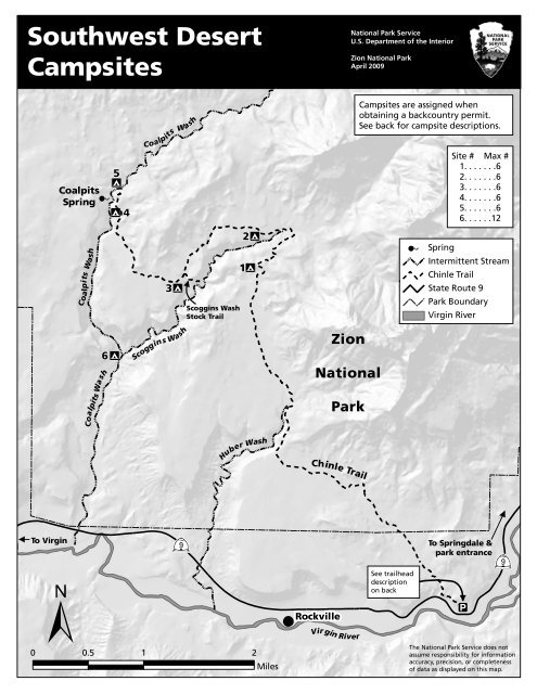
Site # Max #<br />
1. . . . . . .6<br />
2. . . . . . .6<br />
3. . . . . . .6<br />
4. . . . . . .6<br />
5. . . . . . .6<br />
6. . . . . .12<br />
State Route 9<br />
<strong>Park</strong> Boundary<br />
Virgin River<br />
To Springdale &<br />
park entrance<br />
The <strong>National</strong> <strong>Park</strong> <strong>Service</strong> does not<br />
assume responsibility for information<br />
accuracy, precision, or completeness<br />
of data as displayed on this map.
ÆQTrailhead & Campsite DescriptionsÆQ<br />
Chinle Trailhead Location<br />
The trailhead is located of Anasazi<br />
Way on a plateau above Springdale<br />
and Rockville. Drive west from the<br />
park on State Route 9 through<br />
Springdale. Turn right onto Anasazi<br />
Way, which heads uphill on steep<br />
switchbacks. Approximately 500 feet<br />
up the road is the first side road on<br />
your right. Follow this short road to<br />
the parking area and the trailhead.<br />
Land between the trailhead parking<br />
and park boundary is private; please<br />
stay on the designated trail.<br />
1. Temple View Campsite<br />
Temple View is just off the Chinle<br />
Trail to the south on a small ridge. As<br />
the name implies, it has great views of<br />
the West Temple and also of Kinesava<br />
and Scoggins wash.<br />
2. Scoggins Wash Campsite<br />
A short walk off the Chinle trail down<br />
a wash to the south will lead you to<br />
this site. This site has a great slickrock<br />
area that overlooks Scoggins Wash.<br />
3. Yucca Campsite<br />
Yucca is located on a nice sandy area<br />
just south of the Chinle trail. It sits<br />
slightly up on a knoll and is<br />
surrounded by desert vegetation.<br />
4. Coal Pits Ridge Campsite<br />
This site is located on a ridge just<br />
above Coal Pits Wash on the Chinle<br />
Trail. It sits among several boulders<br />
and has great views, and is only a<br />
short walk to Coal Pits Wash where<br />
water is available.<br />
5. Coal Pit Wash Campsite<br />
This site is located at the junction of<br />
Dalton Wash and Coal Pits Wash. It is<br />
located on a sandy area surrounded<br />
by dark lava rock to the north of the<br />
wash. This site is a good location for<br />
further explorations, with the<br />
junction of the Chinle trail nearby.<br />
Water can also be found here.<br />
6. Junction Campsite<br />
This site is located at the junction of<br />
Scoggins and Coal Pits Wash. It is<br />
located on a sandy bench to the west<br />
of the drainage with great views of<br />
the surrounding mesas.<br />
Coalpits Spring<br />
Located in an area downstream of the<br />
Chinle Trail junction, this spring is on<br />
the canyon wall to the west under an<br />
overhang. It can become dry in some<br />
years so check with Backcountry when<br />
making plans.<br />
Location: N 37°12'54.0",<br />
W 113°04'44.5"<br />
Map Datum: WGS 84