

Download - Altea Gallery
Download - Altea Gallery
Download - Altea Gallery

You also want an ePaper? Increase the reach of your titles
YUMPU automatically turns print PDFs into web optimized ePapers that Google loves.
12 ALTEA GALLERY<br />
ITALIAN ENGRAVING<br />
The Italians were the first to use copper engraving to print maps (the technique evolving from decorative metalwork)<br />
and were responsible for some of the most flamboyant maps. From the early Lafreri-school engravers, through Lucini and<br />
Coronelli to the later work published by Zatta and Cassini, Italy produced maps on which there was as much artistry in<br />
the style of engraving as the content.<br />
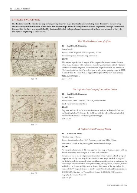
Item 14<br />
Item 15<br />
Item 16<br />
14 GASTALDI, Giacomo.<br />
The ‘Upside-Down’ map of Africa<br />
Prima Tavola.<br />
Venice, c.1563. Trapizoid, 275 x (at greatest) 385mm.<br />
Two sheets joined. Fine and crisp impression.<br />
£1,900<br />
The famous ‘upside-down’ map of Africa, engraved with north to the bottom<br />
of the map, decorated with various sea-monsters, galleons and animals. Gastaldi<br />
produced this finely-engraved version after his original woodcut for Ramusio’s<br />
‘Delle navigationi et viaggi’ was destroyed in a fire at the printing house in 1557.<br />
It is likely that the orientation is supposed to represent the view from Europe.<br />
BETZ: 7; NORWICH: 6.<br />
S/N: 12717<br />
The ‘Upside-Down’ map of the Indian Ocean<br />
15 GASTALDI, Giacomo.<br />
Seconda Tavola.<br />
Venice, Giunti, 1606. Trapizoid, 280 x (at greatest) 385mm.<br />
Small repair bottom centrefold.<br />
£1,600<br />
Engraved with north to the bottom of the map, it shows Arabia (with Bahrain)<br />
on the right, India, Ceylon and the Maldives, with the edge of Sumatra top left.<br />
Published in Ramusio’s ‘Delle navigationi et viaggi’.<br />
S/N: 8172<br />
A “Lafreri-School” map of Iberia<br />
16 FORLANI, Paolo.<br />
[Untitled map of Iberia.]<br />
Venice: Ferrando di Bertelli, c.1567. Two sheets joined, total 435 x 545mm.<br />
Evidence of a crack in the printing plate on the lower left edge.<br />
£9,800<br />
An exceptional example of this rare separate-issue map of Iberia, on paper with an<br />
anchor watermark with margins of at least 4cm on all sides.<br />
Forlani was one of the most prominent members of the ‘Lafreri-school’ group of<br />
mapmakers in Italy. Not only did he publish his own maps, his skills as engraver,<br />
particularly for lettering, made other publishers commission him to make maps for<br />
them: maps attributed to him were published by, among others, Camocio, Bertelli<br />
and Zaltieri in Venice, and Duchetti in Rome. This is one of the few to bear his<br />
name: of the 97 maps attributed to him by David Woodward, eighty are unsigned.<br />
WOODWARD: The Maps and Prints of Paolo Forlani; MAPFORUM.COM: Issue 11,<br />
biography, & Forlani’s Works, 68.<br />
S/N: 7437<br />
WWW.ALTEAGALLERY.COM