

20 DAY CAPE TO VIC FALLS - African Overland Safari Tours
20 DAY CAPE TO VIC FALLS - African Overland Safari Tours
20 DAY CAPE TO VIC FALLS - African Overland Safari Tours

You also want an ePaper? Increase the reach of your titles
YUMPU automatically turns print PDFs into web optimized ePapers that Google loves.
Namib Naukluft Park BOTSWANA<br />
Sossusvlei Dunes<br />
Bushmen Community<br />
Fish River Canyon<br />
Orange River<br />
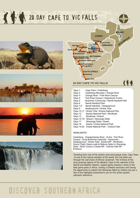
<strong>20</strong> <strong>DAY</strong> <strong>CAPE</strong> <strong>TO</strong> <strong>VIC</strong> <strong>FALLS</strong><br />
HIGHLIGHTS:<br />
SOUTH AFRICA<br />
Cape Town<br />
ZAMBIA<br />
Kasane<br />
Victoria Falls<br />
Etosha<br />
ZIMBABWE<br />
NAMIBIA<br />
Himba Tribes<br />
Windhoek<br />
Swakopmund<br />
Ghanzi<br />
Maun Gweta<br />
Chobe<br />
Okavango Delta<br />
Cederberg<br />
N<br />
W E<br />
MALAWI<br />
Cederberg - Orange/Gariep River - Ai-Ais - Fish River<br />
Canyon - Kung Bushmen (optional) - Sossusvlei -<br />
Swakopmund - Himba Tribe - Etosha NP - Windhoek -<br />
Scenic Flight, Nature walk & Mokoro <strong>Safari</strong> in Okavango<br />
Delta - River Cruise in Chobe NP - Victoria Falls NP<br />
Entrance<br />
Travelling from one of the world’s most picturesque cities, Cape Town,<br />
to one of the natural wonders of the world, this trip takes you<br />
through the vast tracks of <strong>African</strong> savannah. The richness of the<br />
wine growing regions of the Western Cape to the vastness of the<br />
Namib and Kalahari Deserts. Superb game viewing in some of the<br />
best game parks in Africa, visiting a Cheetah sanctuary and having<br />
the opportunity to explore the Okavango Delta by mokoro are just a<br />
few of the highlights presented to you on this action packed<br />
adrenalin adventure.<br />
S<br />
MOZAMBIQUE Days 1 Cape Town / Cederberg<br />
Days 2 Cederberg Mountain / Orange River<br />
Days 3 Orange River / Fish River Canyon<br />
Days 4 Fish River Canyon / Kokerboom Forest<br />
Days 5 Bushman Community / Namib Naukluft Park<br />
Days 6 Namib Naukluft Park<br />
Days 7,8 Namib Naukluft / Swakopmund<br />
Days 9 Swakopmund / Himba Tribe<br />
Days 10,11 Himba Tribe / Etosha National Park<br />
Days 12 Etosha National Park / Windhoek<br />
Days 13 Windhoek / Ghanzi<br />
Days 14-16 Ghanzi / Okavango Delta<br />
Days 17 Okavango Delta / Gweta<br />
Days 18 Gweta / Chobe National Park<br />
Days 19,<strong>20</strong> Chobe National Park / Victoria Falls
Local Payment - $495<br />
Payable in cash to the guide on departure. Only small<br />
denominations ($50, $<strong>20</strong>, $10, $5) notes printed after <strong>20</strong>00<br />
will be accepted.<br />
Countries Visited<br />
South Africa, Namibia, Botswana and Zim babwe.<br />
Important Note: We will only go to Zambia in the unlikely<br />
event that we cannot go to Zimbabwe.<br />
Vehicle<br />
<strong>Overland</strong> Truck<br />
Malaria<br />
Malaria prophylactics are required. Very Low Risk of<br />
Malaria in Northern Namibia, but the risk increases to High<br />
risk as we travel east to Zimbabwe.<br />
Departure Point<br />
8.00am Nomad Adventure <strong>Tours</strong>, 40 Shortmarket Street,<br />
Greenmarket Square, Cape Town, RSA. +27 21 426 5445.<br />
End Point<br />
Elephant Hill Hotel, Park Way Drive, Victoria Falls,<br />
Zimbabwe. Tel: +26 31 344 793/9<br />
What’s included<br />
Meals as indicated on the itinerary, accommodation,<br />
registered guides, transport and selected activities as per<br />
itinerary.<br />
What’s excluded<br />
All items of a personal nature, alcohol, snacks, souvenirs,<br />
tips and optional activities (see list for an indicat ion of<br />
prices).<br />
Health<br />
Please inform us of any pre -existing conditions such as<br />
diabetes or asthma and any prescription medicine you<br />
may be taking. We also need to know about any food<br />
allergies that you may have.<br />
Visas<br />
Please note that these are your respon sibility. Some<br />
nationalities require visas for Namibia and Botswana. Most<br />
nationalities will require visas for Zimbabwe, which can be<br />
obtained at the border. See Pre Departure Booklet for<br />
more information.<br />
N<br />
W E<br />
Climate<br />
The <strong>African</strong> sun is very strong, especially in Namibia and<br />
Botswana. Please use a factor 30 sunscreen and wear a<br />
hat. You should drink at least 3 litres of water per day to<br />
avoid dehydration. It can also get very cold during winter<br />
months on this route. Please see Pre Departure Booklet for<br />
detailed information.<br />
Currency and Banking<br />
South <strong>African</strong> Rand is the most widely used currency on this<br />
route. US Dollar cash is necessary, and can be used for<br />
optional activities. Travellers Cheques can take a long time<br />
to change into cash and often incur unreason able<br />
charges. Credit Cards cannot always be processed –<br />
especially in remote areas. USD Notes printed before <strong>20</strong>00<br />
(i.e. the old style notes) will not be accepted and many<br />
places will not accept USD100 notes, so make sure to bring<br />
lots of $1, $5 and $10 notes for tips and craft markets.<br />
USD<strong>20</strong> and USD50 notes are good to change in to local<br />
currency. Please see Pre Departure Booklet for detailed<br />
information on each country.<br />
Vaccinations<br />
No vaccinations are prescribed by law by the countries<br />
being visited on this tour. Please see the Pre Departure<br />
Information booklet for detailed information on<br />
vaccinations in Africa.<br />
Onward Travel<br />
This tour can be linked to the Kruger Park, East <strong>African</strong><br />
Adventure, South <strong>African</strong> Explorer and Discover<br />
Mozambique tours. Transfer with truck to JHB.<br />
Pre and Post Tour Accommodation<br />
If you require accommodation before or after your tour we<br />
can arrange this for you. We can also arrange airport<br />
transfers – contact your travel agent to make these<br />
bookings.<br />
Arrival<br />
Please be sure to arrive 1 day before your tour is due to<br />
depart. This will avoid any problems such as forgotten<br />
luggage, misplaced bags or any unpredictable problems<br />
such as airline strikes or delayed flight arrival.<br />
Departure<br />
Please book your flight to depart the day after the tour<br />
officially ends. This is to account for any delays that we<br />
may experience due to unpredictable road conditions.<br />
Note: All information is subject to change without prior notice. Travel times can change depending<br />
on road or weather conditions, etc. These are used as a guideline only.<br />
Did you receive your Pre Departure Information Booklet?<br />
If not please contact us at info@africanoverland.co.za and we will e-mail you the document.<br />
You can also download from our website at www.africanoverland.co.za/accommodated_pre_depature_booklet.html<br />
S<br />
PAGE 2
OPTIONAL ACTIVITIES:<br />
COUNTRY AREA ACTIVITY PRICE<br />
Namibia Gariep / Orange River 1/2 day Canoe Trip R 150 to R 170<br />
Namibia Swakopmund Sky Diving R 1,500 to R 2,500<br />
Namibia Swakopmund Quadbiking R 270 to R 600<br />
Namibia Swakopmund Sandboarding R <strong>20</strong>0 to R 300<br />
Namibia Swakopmund Dinner at Local Restaurant R 150 to R 300<br />
Namibia Swakopmund Dolphin Cruise R 400 to R 540<br />
Namibia Swakopmund Horse Riding R 450 to R 470<br />
Botswana Okavango Tips for Polers - Per Day $5 to $8<br />
Botswana Kasane Chobe NP Game Drive $40 to $55<br />
Zimbabwe Victoria Falls White Water Rafting $95 to $1<strong>20</strong><br />
Zimbabwe Victoria Falls Combo River Board and Rafting $125 to $160<br />
Zimbabwe Victoria Falls Bungee Jump $95 to $105<br />
Zimbabwe Victoria Falls Lion Encounter $100 to $1<strong>20</strong><br />
Zimbabwe Victoria Falls Zambezi Sunset Cruise $35 to $45<br />
Zimbabwe Victoria Falls Elephant Visit $100 to $130<br />
Zimbabwe Victoria Falls Dinner at Local Restaurant $<strong>20</strong> to $50<br />
Note:<br />
There are more optional activities being creat ed every day – we have listed only the most popular. If there is something<br />
specific you would like to do then speak to your guide as they will be able to assist you.<br />
<strong>DAY</strong> 1 SOUTH AFRICA – CEDERBERG MOUNTAIN REGION<br />
We depart Cape Town and drive north to the spectacular Cederberg region. We spend some time this afternoon learning<br />
about what to expect as well as the vehicle and equipment.<br />
Meals: Lunch, Dinner<br />
Accommodation: Two per room: Citrus Creek Caravan Park (www.citruscreek.co.za)<br />
Facilities: En suite, hot showers, drinkable water<br />
Route: Cape Town to Citrusdal. ±<strong>20</strong>0 km<br />
Travel time: ±3-4 hrs<br />
N<br />
W E<br />
The Cederberg range, 100km long, is a gigantic mass of sandstone, coloured by iron oxides and eroded into strange shapes.<br />
This area has a rich plant life, including rarities such as the snow protea (only flowers above the snow line) and the Cederberg<br />
or rocket pinchion. The Cedar trees are of the Widdringtonia cederbergensis species. They grow at a n altitude of 1000m to<br />
1500m. Some species are believed to live up to 1000 years. The highest peak in the range is Sneeuberg (<strong>20</strong>28m). In 1660 the first<br />
European explorers from the cape, led by Jan Danckert came across a great herd of elephants in the Olifants River valley. The<br />
source of the river is in the mountains near Ceres. Above Clanwilliam, the Olifants is harnessed by a dam, built in 1935 and<br />
expanded in 1968, which irrigates 12140 hectares of farmland.<br />
<strong>DAY</strong> 2 NAMIBIA - NAMAQUALAND - ORANGE/GARIEP RIVER<br />
We travel through Namaqualand and to the Gariep/Orange River. The night is spent getting to know one another over a<br />
hearty meal.<br />
Meals: Breakfast, Lunch, Dinner<br />
Accommodation: Two per room: Felix Unite.<br />
(www.felixunite.com/accommodation/orange_cabanas.asp)<br />
Facilities: En suite, hot showers, water not drinkable, b ar, washing up area<br />
Route: Citrusdal to Gariep River. ±570 km<br />
Travel time: ±9-10 hrs plus border crossing<br />
In 1681 a party of Nama people visited Cape Town Castle to trade. They brought with them pure copper a nd the then<br />
Governor, Simon Van Der Stel, saw this as proof of tales told by Khoi Khoi informants. In 1685 Va n Der Stel led a major<br />
expedition to the Fables Mountains. No copper was found on the surface, but rocks where stained with the green -blue of<br />
Malachite. Van Der Stel sank three shafts, which r evealed a vast load of copper. After this find, for <strong>20</strong>0 years nothing was done<br />
about it due to the inhospitable environment.<br />
S<br />
PAGE 3
N<br />
W E<br />
The Scottish explorer, Sir James Alexander investigated Van Der Stel’s claims in 1852. He found several other copper outcrops<br />
and started mining. Fortune hunters rushed to the area with many mining company collapsing due to transport difficulties. One<br />
of the two that survived, at Okiep, was ranked as the richest copper mine in the world (Okiep is just north of Springbok).<br />
The Orange River was named after The Dutch Royal family (Oranje). It’s now called the Gariep River. The ri ver runs for about<br />
1<strong>20</strong>0 km. The source is at the Gariep dam near Aliwal North in Eastern Cape. It flows into the sea at Oranjemund on the west<br />
coast forming the border between RSA and Namibia and forms a natural boundary of various provinces in RSA.<br />
<strong>DAY</strong> 3 ORANGE/GARIEP RIVER – FISH RIVER CANYON<br />
In the morning we have the opportunity to experience the Gariep/Orange River by canoe, or spend some time relaxing. Af ter<br />
lunch we travel north to visit the Ai -Ais Hot Springs and overnight close to the mighty Fish River Canyon.<br />
Optional Activities: Half-Day Canoe Adventure.<br />
Meals: Breakfast, Lunch, Dinner<br />
Accommodation: Two per room: Canyon Mountain Camp.<br />
( www.gondwana-desert-collection.com/cmc.htm)<br />
Facilities: Shared facilities, hot showers, drinkable water, small kiosk<br />
Route: Gariep River to Fish River Canyon. ± 180 km<br />
Travel Time: ± 3-4hrs<br />
The Fish River Canyon is the second largest canyon in the world. It is approx 161 km long, 27km wide at its widest point, and<br />
550m deep. It is the oldest canyon in the world. The rocks at the bottom of the canyon are 2600 million years old. It was formed<br />
in part by glacial movements, erosion and movement of tectonic plates. The plateaus are 2<strong>20</strong>m from the base of the canyon.<br />
There are catfish at the bottom that survive the dry season by burrowing into the mud until the water returns. It’s a very slow<br />
moving and shallow river – more like a stream. Water is present in Feb/Mar/Apr. The highest recorded temperature at the base<br />
was 58 degrees and it’s usually ten degrees hotter at the bottom than where you stand on the ridge.<br />
<strong>DAY</strong> 4 FISH RIVER CANYON - KOKERBOOM FOREST<br />
After an early breakfast we take a scenic walk along the rim of the Fish River Canyon. After visiting the canyon we travel further<br />
inland to the Kalahari area of Namibia. On the way we will visit the Kokerboom (Quiver tree) Forest.<br />
Meals: Breakfast, Lunch, Dinner<br />
Accommodation: Two per room: Auob Lodge. (www.nimibialodges.com)<br />
Facilities: hot showers, drinkable water, and a swimming pool<br />
Route: Fish River Canyon to Gochas. ±480 km<br />
Travel time: ± 7-8 hrs<br />
<strong>DAY</strong> 5 BUSHMAN COMMUNITY – NAMIB-NAUKLUFT PARK<br />
This morning those who wish to spend some time with the !Kung tribe will have the chance to do so. Later we drive west<br />
towards the massive dunes of Sossusvlei. Optional Activities: <strong>African</strong> Tribal interaction.<br />
Meals: Breakfast, Lunch, Dinner<br />
Accommodation: Two per room/Permanent Tent: Hammerstein Lodge. (www.hammerstein.com.na)<br />
Facilities: Shared facilities, hot showers, drinkable water<br />
Route: Mariental to Hammerstein. ±240 km<br />
Travel time: ± 4-5hrs<br />
The oldest and most unique desert in the world, t he central Namib stretches over <strong>20</strong>00km along the coast from the Olifant’s<br />
River in the south to San Nicolau in Southern Angola. Much of the desert is linear dunes, which are parallel to the sea and<br />
stretch from the coast to the inland gravel plains. These dunes may se em lifeless, but support a complex ecosystem capable of<br />
extracting moisture from the frequent fogs.<br />
The desert was formed by a combination of activities. The Orange/Gariep River combined with the Fish River deposit a great<br />
deal of silt into the ocean. Long shore currents push this silt northwards along the coast and onshore winds and wave action<br />
deposit this silt on to the shoreline. Over the millions of years this belt of sand has pushed further inland and upwards forming<br />
the Namib Desert. The sand is ve ry orange in some places because of the iron ore in the sand, which has simply rusted.<br />
S<br />
PAGE 4
N<br />
W E<br />
<strong>DAY</strong> 6 NAMIB-NAUKLUFT NATIONAL PARK<br />
When we enter the Sossusvlei area we are joined by a local expert to learn about the unique desert ecosystem. After the tour<br />
you can hike up Dune 45 for some photos or take a rest, before an afternoon excursion to the small Sesriem canyon.<br />
Meals: Breakfast, Lunch, Dinner<br />
Accommodation: Two per room: Hammerstein Lodge . (www.hammerstein.com.na)<br />
Facilities: Shared facilities, hot showers, drinkable water.<br />
Route: Hammerstein to Sossusvlei. ±230 km (return journey)<br />
Travel time: ± 3-4hrs<br />
At the entry to Sossusvlei is Sesriem Canyon. As a result of erosion over many centuries, a narrow gorge of about one kilometre<br />
in length was formed about 30 to 40 meters deep. Early explorers had to tie si x lengths of thongs (long Reign s for cart horse)<br />
together to draw water from the pools in the canyon, hence the name "Sesriem".<br />
The mean or average rainfall is used to class areas as either extre mely arid (hyper-arid) with a mean rainfall of less than 100mm<br />
of rain per year; arid, with a mean rainfall between 100 -250mm per year; semi -arid with 250-500mm of rain a year. About 16%<br />
of Namibia’s land surface is hyper -arid. The Namib is hyper -arid with a rainfall of less than 100mm a year. In its driest areas the<br />
annual potential evaporation is 3500mm whereas the annual rainfall is <strong>20</strong>mm.<br />
The Namib is a long narrow desert stretching along the west coast of Southern Africa, from the Olifants River in So uth Africa, to<br />
the Carunjamba River in Angola - about <strong>20</strong>00km. The name Namib, is of Nama origin with the modern spelling referring to a<br />
desert, but a particular part of the desert, specifically a large plain. The dune sands are primarily derived from sedime nts<br />
washed down the Orange River and then moved northwards by the long shore drift plus the dominant southerly quadrant<br />
winds. The winds move the sand northwards and inland, trappi ng it by wave action in coastal embayment. Dune sand consists<br />
of 90-95% Quartz (Silica) grains and 10-15% Mica, feldspar and heavy minerals such as garnet, ilmenite and magnetite. The<br />
sand tends to be redder towards the east as a result of increasing quantities of an iron (ferric) oxide incrustation on the sand<br />
grains. This is a form of rusting of the quartz grains and is related to age, temperature and moisture.<br />
The types of dunes found are Star dunes, formed as a result of wind coming equally strong from all directions; Barchan’s dunes,<br />
are crescent shaped and formed where wind is mainly from one direction and with a shortage of sand and the Linear dunes,<br />
which are long dunes with sharp crests that tend to lie in parallel rows. They are a result of two dominant winds in the central<br />
Namib- Southerly and Easterly winds. Linear dunes form in a south to north direction.<br />
<strong>DAY</strong> 7 SWAKOPMUND<br />
Today we cross the Tropic of Capricorn on our way through the desert. Our first stop is Walvis Bay where we may see some<br />
flamingos. On arrival in Swakopmund you will be briefed on the different optio nal activities available.<br />
Optional Activities: Dinner, Quad biking, Sand boarding, Sky Diving, Scenic Flights etc.<br />
Meals: Breakfast, Lunch<br />
Accommodation: Two per room: Villa Wiese (www.villawiese.com) / Dunedin<br />
(www.dunedinstar.com)<br />
Facilities: En suite, hot showers, drinkable water, cash bar, laundry service<br />
Route: Hammerstein to Swakopmund. ±300 km<br />
Travel time: ±4-5 hours (including Walvis Bay)<br />
<strong>DAY</strong> 8 SWAKOPMUND<br />
This day is left free for you to explore the town or try one of the many adventur e activities.<br />
Optional Activities: Quad biking, Sky diving, Sand boarding, scenic Flights etc<br />
Meals: Breakfast, Lunch, Dinner<br />
Accommodation: Two per room: Villa Wiese (www.villawiese.com) / Dunedin (www.dunedinstar.com)<br />
Facilities: En suite, hot showers, drinkable water, cash bar, laundry service<br />
The Topnaar people who live in the valley of the Swakop river (at whose mouth the town lies) gave the name on account of<br />
the mud, flotsam, and general detritus washed down during its infrequent floods, whi ch reminded them of very loose<br />
evacuation of the bowels.<br />
The Germans, in the process of expanding their colony in South West Africa, needed a port, but the only natural harbour on this<br />
part of the coast was Walvis Bay, which was already annexed to the Cap e. The Germans decided to make the best of the<br />
place, creating an artificial harbour there and building a narrow -gauge routing to convey goods across the Namib to the<br />
interior. A military fort was built here in 1892, which was the beginning of Swakopmund. The building of the railway began in<br />
1895. After the First World War, Germany lost occupation and th e port/harbour was automatically displaced by Walvis Bay.<br />
S<br />
PAGE 5
<strong>DAY</strong> 9 HIMBA TRIBE<br />
Heading inland, we drive north towards Kamanjab where we meet with the local peo ple from this area. The Himba are a<br />
pastoral people and predominantly breed cattle or goats. Encountering a totally different way of life can be a moving<br />
experience for many people.<br />
Meals: Breakfast, Lunch, Dinner<br />
Accommodation: Two per room: Oase Lodge (www.namplaces.com)<br />
Facilities: En suite, hot showers, bar, drinkable water<br />
Route: Swakopmund to Kamanjab. ±650 km<br />
Travel time: ±7-8 hrs. Long Day<br />
N<br />
W E<br />
The Himba ethnic groups, who have kept their ethnic individuality and culture, live in the seclusi on of the Kaokoland. The<br />
friendly people are closely related to the Herero. Both ethnic groups speak the same language. Depending on the time of<br />
year, they move with their herds to different watering places. Clothes, hairstyle and jewellery are all of part icular significance to<br />
the Himba and are part of their tradition and culture. Even newborn babies are adorned with pearl necklaces. When the<br />
children are a little older, bangles made of beaten copper and shells are added.<br />
The proud Himba women take sever al hours for beauty care every morning. The entire body is rubbed with a cream, which<br />
consists of rancid butterfat and ochre powder. The aromatic resin of the Omuzumba bush is added as well. The cream lends<br />
the body an intense reddish shine, which correspo nds to the Himba ideal of beauty.<br />
The ancient tribe of semi -nomadic pastoralists occupied Kunene region of the country. The Himba’s (who are relatives of<br />
Herero) are an extraordinary people who have resisted change and preserved their unique cultural her itage. The Himba’s<br />
were impoverished by Nama cattle raiders in the middle of 1800's and then forced to be hunter -gatherers. Because of these<br />
events they were called the Tjimba, derived form the word meaning aardvark, the animal that digs for its food. Many Himba’s<br />
fled to Angola where they were called Ovahimba, meaning 'beggars'. They left with their leader called Vita (''war'').<br />
After World War 1 he resettled his people in Kaokoland. Since these events the Himba’s were living their nomadic pastoralist<br />
lives. But now more and more they have to reconcile traditional ways with European values. One of most interesting rituals of<br />
these people is that of the ritual fire, the ''okoruwo''. The fire provides contact between the living and the dead, which is<br />
necessary for harmonious living and keeping the ancestors happy. It is kept alive until the death of the headman. When this<br />
happens, his hut and the fire is destroyed. His family dance in mourning throughout the night. Before his burial everyone says to<br />
him: "Karepo nawa" (''keep well''). Later a fresh mopane tree is lit from the embers of the old fire.<br />
<strong>DAY</strong> 10/11 E<strong>TO</strong>SHA NATIONAL PARK<br />
After an early breakfast we enter Etosha NP for some superb game viewing. We will visit water -holes to wait for the animals to<br />
come and drink as well as explore as much as we can of the NP. One night will be spent inside the park where we can see the<br />
nocturnal animals at the floodlit waterhole.<br />
Meals: Breakfast, Lunch, Dinner<br />
Accommodation: Day 10: Two per room; Depending on the time of year we will stay in the best area of<br />
the park for game viewing at a Namibia Wildlife Resort Campsite<br />
(www.nwr.com.na/etosha.htm)<br />
Day11: i Dream Africa Lodge. (just outside the gate of Etosha)<br />
Facilities: Drinkable water, good ablutions, bar, shop, post box, swimming pool and waterholes<br />
at all campsites<br />
Route: Kamanjab to Etosha NP. ±2<strong>20</strong> km<br />
Travel time: ±3-4 hrs<br />
Etosha National Park, with its wealth of animal and plant life, lies in the North of Namibia and covers an area of 22 270km2; the<br />
Etosha pan’s size is 4 590km2. In 1851 the explorers Sir Francis Galton and Charles Anderson were the first Europeans to visit the<br />
great pan known as Etosha (the white place of mirages). The area around it teemed with game animals and the spectacle<br />
during the rainy season of December to March, with the pan filled with mud more than a meter deep and countless flamingos<br />
resting here, made this one of the most exciting wildlife areas in Africa.<br />
S<br />
PAGE 6
N<br />
W E<br />
Fifty years later the German government built a fort at the east ern end of the pan, at Namutoni. In 1904 the Wambo attacked<br />
this fort, fortunately only seven German policemen were stationed in the fort at the time and they were short of ammunition,<br />
after seven hours of fighting they slipped away in the night and made t heir way southwards until they encountered a German<br />
colony coming to their relief. The combined party returned to the fort in Etosha and recaptured it, the fort had been badly<br />
looted and largely destroyed by the Wambo warriors, as a result a new fort was built – a glistening white, ‘Beau Geste’<br />
stronghold, which until today has never been under attack, the new fort was a police post until the 1950’s. In 1907 the German<br />
government proclaimed Etosha Pan and its surroundings a game reserve. The amenities were built until 1952 however, when<br />
the construction of rest camps and roads began, particularly along the southern edge of the pan, where there are perennial<br />
waterholes that attract a concentration of wild animals.<br />
During the rainy season, animals are scatte red over a vast grazing area, congregating in large numbers on the plains west of<br />
the pan where the grazing is good. At this time bird life in the pan is varied. The 400mm of rain that falls annually also creates<br />
muddy roads and excellent conditions for ma laria carrying mosquitoes. Temperatures are consistently high - around 38 Celsius -<br />
and life is not very comfortable. In the winter temperatures drop to below 3 degrees Celsius at night.<br />
<strong>DAY</strong> 12 WINDHOEK<br />
On our way to Namibia’s capital city we stop at a cra ft market so you can purchase some authentic <strong>African</strong> creations.<br />
Windhoek is situated at almost the exact centre of Namibia. In the afternoon we’ll take you on a short tour of the city.<br />
Optional Activities: Dinner at Joe’s Beer House.<br />
Meals: Breakfast, Lunch<br />
Accommodation: Two per room: Cori Guest House (www.pension-cori-namibia.com)<br />
Facilities: En suite, hot showers, drinkable water<br />
Route: Etosha NP to Windhoek. ±622 km<br />
Travel time: ±7-9 hrs. Long day<br />
Windhoek is home to approximately two hundr ed thousand people, which is an extremely small capital by global standards.<br />
This number is growing rapidly at present mostly due to a lack of employment in rural areas. Despite the large increase in<br />
population over the last few years the city centre is ex tremely clean, and mostly trouble free. Most tourists comment on the<br />
cleanliness of the city, and often pronounce Windhoek to be a most un -<strong>African</strong> city. As can be expected from a capital city,<br />
Windhoek is home to many of the best hotels in Namibia, the cit y also offers several other accommodation establishments<br />
ranging from backpackers to up -market guest houses.<br />
<strong>DAY</strong> 13 GHANZI, BOTSWANA<br />
We take a scenic drive to the Buitepos border, where we enter Botswana. Once at the lodge we meet with a local Bushman<br />
community and see some traditional Tribal Dancing.<br />
Meals: Breakfast, Lunch, Dinner<br />
Accommodation: Two per room: Tautona Lodge. (www.namibweb.com/tautonalodge.htm)<br />
Facilities: Hot showers, good ablutions, bar.<br />
Route: Windhoek to Ghanzi. ±516 km<br />
Travel time: ±8-9 hrs, plus a border crossing on this day.<br />
The San People who were formally know as the Bushmen, are indigenous to Botswana (and Namibia) and have lived here for<br />
over 30,000 years. It is truly an incredible experience to get an understanding of what Africa was like so many years ago and<br />
how the people survived in these desert conditions when their very existence was based on the land.<br />
It is said that the word San meant ‘wild people who can’t farm’, howe ver historically they didn’t have a collective word for<br />
themselves. Now they call themselves Ncoakhoe meani ng ‘red people’, but is seems San has stuck. They were nomadic<br />
people – primarily hunter gathers, moving to where the food and water could be found.<br />
It is estimated that there are 55,000 San people left, with 60% of them living in Botswana and many exampl es of their cave<br />
drawing can be found dotted around. Sadly nowadays, their existence is similar to the aboriginals and can be found in 'squalid<br />
alcohol plagued settlements' or on farms and cattle posts.<br />
You will notice a visible difference between Botswana and Namibia; that being people and livestock; as we cross the border<br />
we’ll start to see villagers, cattle, donkeys, and sheep roaming along the side of the highway. Sometimes the cows sit in the<br />
middle of the road and any amount of blowing a horn w on't get them out of the road.<br />
S<br />
PAGE 7
N<br />
W E<br />
Independent since 1966 (formally a British protectorate) three of the world’s richest diamond mines were discovered in the<br />
country, this has made Botswana quite a rich nation, allowing them to pick and choose their future. Now 40y rs old, it is known<br />
as the <strong>African</strong> success story. Politically stable and with the foresight to invest in education, healthcare, high economic<br />
standards and without the racial issues that have plagued other countries has resulted in Botswana having the best economy<br />
(outside of South Africa) in sub -Saharan Africa.<br />
The government has employed a strategy of high income - low impact tourism. This is where they reduce the number of tourists<br />
entering any area of the country by charging a lot more than neighbouring countries, thereby making it more restrictive for the<br />
budget traveller. The economical way to travel through the country is to camp and there are many campsites, even some of<br />
the popular and renowned lodges have camping facilities. Winter is the best time to go and that is between May to August<br />
when the days are warm and sunny; the nights can be cold (at times) but it’s quite pleasant. This is also the best time to see<br />
wildlife as the animals never wonder far from their water source. The summer last s from October to April and the rains can<br />
make some of the roads impassable.<br />
<strong>DAY</strong> 14/15/16 MAUN – OKAVANGO DELTA<br />
Maun is well known as the gateway to the Okavango Delta. We spend one night in this remote town and prepare for this<br />
excursion. Small planes transp ort us over this amazing area to Gunn’s Camp for the next 2 nights. Animals are often spotted<br />
from the lodge, but we also take a nature walk and, if the water level allows, a mokoro (traditional canoe) trip.<br />
Meals: Breakfast, Lunch, Dinner<br />
Accommodation: Two per room/Permanent Tent: Crocodile Camp. (www.crocodilecamp.com)<br />
Facilities: Hot showers, good ablutions, bar.<br />
Route: Ghanzi to Maun. ±283 km<br />
Travel time: ±4-5 hrs<br />
Delta Day 1 (Day 15)<br />
Meals: Breakfast, Lunch, Dinner<br />
Accommodation: Two per tent: Antelope accommodation , Gunns Camp. (www.gunnscamp.com)<br />
Facilities: Hot showers, good ablutions, bar.<br />
Route: Maun to Delta. ±3<strong>20</strong> km<br />
Travel time: Flight out<br />
Delta Day 2 (Day 16)<br />
Meals: Breakfast, Lunch, Dinner<br />
Accommodation: Two per tent: Antelope accommodation , Gunns Camp. (www.gunnscamp.com)<br />
Facilities: Hot showers, good ablutions, bar.<br />
Maun<br />
Since Maun's founding in 1915 as the tribal capital of the Batawana people, it has had a reputation as a hard -living 'Wild West'<br />
town helping the local cattle ranching and hunting operations. However, with the growth of the tourism industry and the<br />
completion of the tar road from Nata in the early 1990s, Maun has developed swiftly, losing much of its old town character. It is<br />
now home to over 30,000 people. Maun is today a thriving, chaotic tourist town, infamous for its infestation of donkeys and to<br />
lesser extent goats. These animals can be seen standing around on their own as the local farmers arrive in the innumerable<br />
taxis to sell their wares on the kerbside.<br />
With the influx of tourism dollars, the typical traditional Rondavels of yesteryear have been replaced by square but modestly<br />
sized cinderblock homes roofed with tin and, rarely, tiles. It is not unusual to see mud rondavels with satellite di shes, attesting to<br />
the increasing affluence of Botswana, and the increasingly reliability of power and communications in Maun. Likewise, mobile<br />
phone service in Maun is excellent out to about <strong>20</strong> to 25km depending on weather. Opposite the main shopping stri p which<br />
has grown around Riley’s Garage, multi-level air-conditioned shopping centres are incongruously surrounded by potholes dusty<br />
or muddy car parking lots, also inevitably a marketplace for whoever wishes to sell. There is now, also, no less than three major<br />
chain supermarkets, Cbstor e, Spar and a Nandos.<br />
Okavango Delta<br />
The Okavango Delta is one of the world’s largest inland water systems. Its headwaters start in Angola’s western highlands, with<br />
numerous tributaries joining to form the Cubango River, w hich then flows through Namibia (called the Kavango) and finally<br />
enters Botswana, where it is then called the Okavango. Millions of years ago the Okavango River use d to flow into a large<br />
inland lake called Lake Makgadikgadi (now Makgadikgadi Pans). Tectoni c activity and faulting interrupted the flow of the river<br />
causing it to back up and form what is now the Okavango Delta. This has created a unique system of waterways that now<br />
supports a vast array of animal and plant life that would have otherwise been a dry Kalahari Savanna.<br />
S<br />
PAGE 8
N<br />
W E<br />
The delta’s floods are fed from the Angolan rains, which start in October and finish sometime in April. The floods only cross the<br />
border between Botswana and Namibia in December and will only reach the bottom end of the delta (Maun) sometime in<br />
July, taking almost nine months from the source to the bottom. This slow meandering pace of the flood is due to the lack of<br />
drop in elevation, which drops a little more than 60 meters over a distance of 450 kilometres. The delta’s water dead-ends in<br />
the Kalahari – via the Botetle River, with over 95 per cent of the water eventually evaporating. During the peak of the flooding<br />
the delta’s area can expand to over 16,000 square kilometres, shrinking to less than 9,000 square kilometres in the low period.<br />
As the water travels through the delta, the wildlife starts to move back into the region. The areas surrounding the delta are<br />
beginning to dry out (the rains in Botswana occur approximately the same time as in Angola) and the wildlife starts to<br />
congregate on the edge of the newly flooded areas, May through October.<br />
The delta environment has large numbers of animal populations that are otherwise rare, such as Crocodile, Red Lechwe,<br />
Sitatunga, Elephant, Wild dogs, Buffalo, Wattled crane, as well as the other more common mammals and bird life. The best<br />
time for game viewing in the delta is during the May -October period, as the animal life is concentrated along the flooded<br />
areas and the vegetation has dried out. The best time for birding and vegetation is during the rainy season (Nov - April) as the<br />
migrant bird populations are returning and the plants are flowering and green.<br />
<strong>DAY</strong> 17 GWETA<br />
A second scenic air-transfer will return us to Maun and the truck. This afternoon we drive to Gweta where our even ing<br />
accommodation is unique, and a little quirky.<br />
Meals: Breakfast, Lunch, Dinner<br />
Accommodation: Two per room: Gweta, Planet Baobab . (www.uncharteredafrica.com)<br />
Facilities: Hot showers, good ablutions and a bar.<br />
Route: Delta to Gweta. ±<strong>20</strong>1 km<br />
Travel time: ± 3-4hrs<br />
The Boteti River, once a broad strong -flowing waterway fed by waters drained from the Okavango during the months of June<br />
and July annually, later dwindling to a chain of pools, and finally ceased flowing in September 1992. The last few deep<br />
permanent pools that remain are competed for by humans, livestock and wildlife, causing considerable conflict. It is hoped by<br />
all that the present drought cycle will soon be broken.<br />
Makgadikgadi, the name of which implies a vast open lifeless land, is not without its folklore. There are stories of people setting<br />
out from Gweta to explore the land that lay between them and the Boteti River to seek a favourable environment in which to<br />
settle. They entered these great thirst lands at the driest time of year, drawn by what they perceived as large lakes of sparkling<br />
water on the horizon. Suffering badly from thirst, the lakes kept drawing them hurriedly on in their attempts to reach the life -<br />
giving water that always remained just ahead of them. Gradually, one by one, they fell and died.<br />
But Makgadikgadi is not always dry. The pans, which are situated in half the south, east and north eastern areas of the park, fill<br />
with water during the rains from mid -November and mostly retain their water into April or M ay. The "thirst lands" are then<br />
transformed into great sheets of water, which attract a spectacular array of water birds and trigger dramatic migrations of<br />
wildebeest and zebra. It is unfortunate that this huge water spectacle becomes practically inaccessi ble by road at this time,<br />
but anyone fortunate enough to fly over the area during the wet season sees a water wonderland of incredible scenic beauty.<br />
Makgadikgadi was initially state land. People have never been resident in its waterless interior, but in times of drought,<br />
surrounding villagers were permitted to graze their livestock within the area, withdrawing them to their homes when conditions<br />
improved. The area was declared a game reserve in 1970 and in December 1992, the boundaries were extended and<br />
National Park status was attained. The present park covers some 4,900 square kilometres. Both dry season and wet season visits<br />
to this park are recommended in order to witness the dramatic appearance of the pans at their driest and to experience the<br />
transformation to a water wonderland, and see the wildebeest and zebra migrations, in the wet season.<br />
<strong>DAY</strong> 18 BOTSWANA – KASANE - CHOBE NATIONAL PARK<br />
We drive north to Kasane, where we stay on the bank of the Chobe River. We take an afternoon river cruise in orde r to visit<br />
Chobe NP’s animals as they come down to the river to drink.<br />
Meals: Breakfast, Lunch, Dinner<br />
Accommodation: Two per room/Permanent Tent: Toro <strong>Safari</strong> Lodge (www.torolodge.co.bw)<br />
Facilities: En - Suite, hot showers, drinkable water (except a t high water), swimming pool, bar<br />
Route: Gweta to Kasane. ± 430km<br />
Travel time: ± 6-7hrs plus a border crossing<br />
S<br />
PAGE 9
N<br />
W E<br />
The original inhabitants of what is now the park were the San people, otherwise known in Botswana as the Basarwa. They were<br />
hunter-gatherers who lived by moving from one area to another in search of water, wild fruits and wild animals. The San were<br />
later joined by groups of the Basubiya people and later still, around 1911, by a group of Batawana led by Sekgoma. When the<br />
country was divided into various land tenure systems, late last century and early this century, the larger part of the area that is<br />
now the national park was classified as crown land.<br />
In 1931 the idea of creating a national park in the area was first mooted, in order to protec t the wildlife from extinction and to<br />
attract visitors. In 1932, an area of some 24,000 square kilometres in the Chobe district was declared a non -hunting area and<br />
the following year, the protected area was increased to 31,600 square kilometres. However, h eavy tsetse fly infestations<br />
resulted in the whole idea lapsing in 1943. In 1957, the idea of a national park was raised again when an area of about 21,000<br />
square kilometres was proposed as a game reserve and eventually a reduced area was gazetted in 1960 as Chobe Game<br />
Reserve. Later, in 1967, the reserve was declared a national park - the first national park in Botswana.<br />
There was a large settlement, based on the timber industry, at Serondela, some remains of which can still be seen today. This<br />
settlement was gradually moved out and the Chobe National Park was finally empty of human occupation in 1975. In 1980<br />
and again in 1987, the boundaries were altered, increasing the park to its present size of 11000 sq km. The wildlife is plentiful,<br />
especially in the dry winter months when great concentrations of elephant, buffalo and zebra congregate along the river, with<br />
giraffe, impala and roan antelope being seen in the forests. The birdlife is diverse, if not overwhelming in its numbers. Water<br />
birds, including pelican, are common. President Clinton and Nelson Mandela have visited the park and Elizabeth Taylor has<br />
had one of her weddings at the Chobe Lodge, in side the park.<br />
<strong>DAY</strong> 19 ZIMBABWE - <strong>VIC</strong><strong>TO</strong>RIA <strong>FALLS</strong><br />
After crossing into Zimbabwe we have a short briefing on a ll the activities available here. Then we enter the much anticipated<br />
Victoria Falls NP where we will experience the might of the great Zambezi River. The popular optional sunset cruise includes<br />
dinner and drinks. Optional Activities: Chobe Game Drive, Z ambezi Sunset Cruise, dinner in local restaurant.<br />
Meals: Breakfast, Lunch<br />
Accommodation: Two per room: Elephant Hills Hotel (zimsun.co.za)<br />
Facilities: Drinkable water, hot showers, good ablutions, bar, swimming pool<br />
Route: Kasane to Vic Falls. ±100 km<br />
Travel time: ±2 hrs plus border crossing<br />
Here the river plunges 108 meters into the gorge below, forming the Victoria Falls, named in 1855 by David Livingstone in<br />
honour of his Queen, also known as “mosi -oa-tunya” - the smoke that thunders. In the season of floods - March o June - the<br />
river swells greatly, but the shallow valley contains it and the movement of the water is still slow. Only a few minor rapids high<br />
up the valley, and the small Gonye falls, give it a flurry of speed. Along the full wid th of its course the river tumbles into a deep<br />
trench only about <strong>20</strong>0m wide. The Falls measures 1708 meters across and has a mean maximum flow of 700 000 cubic meters<br />
per minute.<br />
The Zambezi River has eroded the soft earth filled cracks in the original vo lcanic basalt plateau and has, during the past half<br />
million years, cut back a deep zigzag path forming a gorge 100 kilometres in length. The falls are divided into the Devil’s<br />
Cataract (27m wide and 60 m high), the main falls, which in turn are divided by a projecting rock (524m + 297m wide and 83m<br />
high) and the Eastern Cataract 304m wide and 96m high.<br />
<strong>DAY</strong> <strong>20</strong> <strong>VIC</strong><strong>TO</strong>RIA <strong>FALLS</strong><br />
Most people will spend the day white water rafting, a not -to-be-missed experience of a lifetime! Vic Falls offers many exciting<br />
alternatives. Optional Activities: White Water Rafting, Bungee Jump, Elephant Excursion and many more.<br />
Meals: Breakfast<br />
Accommodation: Own Arrangements<br />
NB – It is possible to book our NTVJ transfer to Johannesburg (2 -days) straight after this tour, as this is one of the cheapest ways<br />
to get from Victoria Falls to Johannesburg.<br />
S<br />
PAGE 10