

ReDharavi
ReDharavi
ReDharavi

You also want an ePaper? Increase the reach of your titles
YUMPU automatically turns print PDFs into web optimized ePapers that Google loves.
72<br />
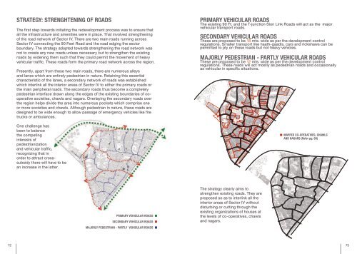
stRAtegy: stRengHtening of RoAds<br />
The first step towards initiating the redevelopment process was to ensure that<br />
all the infrastructure and amenities were in place. That involved strengthening<br />
of the road network of Sector IV. There are two main roads running across<br />
Sector IV connecting the 90 Feet Road and the road edging the sector<br />
boundary. The strategy adopted towards strengthening the road network was<br />
not to create any new roads unless necessary but to strengthen the existing<br />
roads by widening them such that they could permit the movement of heavy<br />
vehicular traffic. These roads form the primary road network across the region.<br />
Presently, apart from these two main roads, there are numerous alleys<br />
and lanes which are entirely pedestrian in nature. Retaining this essential<br />
characteristic of the lanes, a secondary network of roads was established<br />
which interlink all the interior areas of Sector IV to either the primary roads or<br />
the main peripheral roads. The secondary roads thus become a completely<br />
pedestrian interface drawn along the edges of the existing boundaries of cooperative<br />
societies, chawls and nagars. Overlaying the secondary roads over<br />
the region helps divide the area into numerous pockets which comprise one<br />
or more societies and chawls. Although pedestrian in nature, these roads are<br />
designed to be wide enough to allow passage of emergency vehicles like fire<br />
trucks or ambulances.<br />
One challenge has<br />
been to balance<br />
the competing<br />
interests of<br />
pedestrianization<br />
and vehicular traffic,<br />
recognizing that in<br />
order to attract crosssubsidy<br />
there will have to be<br />
an increase in the latter.<br />
pRimARy VeHicuLAR RoAds<br />
secondARy VeHicuLAR RoAds<br />
mAjoRLy pedestRiAn - pARtLy VeHicuLAR RoAds<br />
pRimARy VeHicuLAR RoAds<br />
The existing 90 Ft. and the T-junction Sion Link Roads will act as the major<br />
vehicular transport roads.<br />
secondARy VeHicuLAR RoAds<br />
These are proposed to be 18 mts. wide as per the development control<br />
regulations. Smaller transport like haath-gaadis, cars and rickshaws can be<br />
permitted to ply on these roads but not heavy vehicles.<br />
mAjoRLy pedestRiAn - pARtLy VeHicuLAR RoAds<br />
These are proposed to be 12 mts. wide as per the development control<br />
regulations. These roads will act mostly as pedestrian roads and occasionally<br />
as vehicular in specific situations.<br />
The strategy clearly aims to<br />
strengthen existing roads. They are<br />
proposed so as to interlink all the<br />
interior areas of Sector IV without<br />
disturbing or cutting through the<br />
existing organizations of houses at<br />
the levels of co-operatives, chawls<br />
and nagars.<br />
mApped co-opeRAtiVes, cHAwLs<br />
And nAgARs (Refer pg. 60)<br />
73