- Page 1 and 2: PERFORMANCE SPECIFICATION DIGITAL N
- Page 3: MIL-PRF-89023 the issues of documen
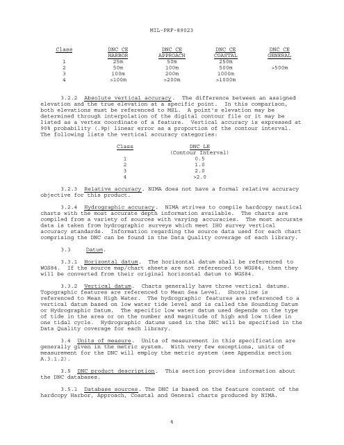
- Page 7 and 8: MIL-PRF-89023 parallel of the quadr
- Page 9 and 10: MIL-PRF-89023 3.6 DNC structure lev
- Page 11 and 12: MIL-PRF-89023 notes related attribu
- Page 13 and 14: MIL-PRF-89023 TABLE 4. Field type a
- Page 15 and 16: MIL-PRF-89023 Following every heade
- Page 17 and 18: MIL-PRF-89023 TABLE 7. Table descri
- Page 19 and 20: MIL-PRF-89023 GENERAL, HARBOR, APPR
- Page 21 and 22: MIL-PRF-89023 TABLE 13. HARBOR cove
- Page 23 and 24: MIL-PRF-89023 c. Coverage attribute
- Page 25 and 26: MIL-PRF-89023 TABLE 18. Cultural La
- Page 27 and 28: MIL-PRF-89023 TABLE 18. Cultural La
- Page 29 and 30: MIL-PRF-89023 TABLE 19. Earth Cover
- Page 31 and 32: MIL-PRF-89023 TABLE 21. Hydrography
- Page 33 and 34: MIL-PRF-89023 TABLE 22. Inland Wate
- Page 35 and 36: MIL-PRF-89023 TABLE 23. Land Cover
- Page 37 and 38: MIL-PRF-89023 TABLE 24. Limits feat
- Page 39 and 40: MIL-PRF-89023 TABLE 25. Aids to Nav
- Page 41 and 42: MIL-PRF-89023 TABLE 26. Obstruction
- Page 43 and 44: MIL-PRF-89023 TABLE 27. Port Facili
- Page 45 and 46: MIL-PRF-89023 TABLE 30. Tile Refere
- Page 47 and 48: MIL-PRF-89023 TABLE 38. Example not
- Page 49 and 50: MIL-PRF-89023 b. BROWSE area join t
- Page 51 and 52: MIL-PRF-89023 names in the edge tab
- Page 53 and 54: MIL-PRF-89023 TABLE 57. Schema for
- Page 55 and 56:
MIL-PRF-89023 TABLE 61. HARBOR feat
- Page 57 and 58:
MIL-PRF-89023 TABLE 62. APPROACH fe
- Page 59 and 60:
MIL-PRF-89023 TABLE 63. COASTAL fea
- Page 61 and 62:
MIL-PRF-89023 TABLE 64. GENERAL fea
- Page 63 and 64:
MIL-PRF-89023 3.9.3. Minimum polygo
- Page 65 and 66:
MIL-PRF-89023 3.15.4 Cardboard slee
- Page 67 and 68:
MIL-PRF-89023 GEOREF World Geograph
- Page 69 and 70:
A.1. SCOPE. MIL-PRF-89023 Appendix
- Page 71 and 72:
MIL-PRF-89023 Appendix A CUL A.3.2.
- Page 73 and 74:
MIL-PRF-89023 Appendix A CUL AL015
- Page 75 and 76:
POINT FEATURES MIL-PRF-89023 Append
- Page 77 and 78:
MIL-PRF-89023 Appendix A CUL ACC Ac
- Page 79 and 80:
MIL-PRF-89023 Appendix A CUL TABLE
- Page 81 and 82:
MIL-PRF-89023 Appendix A CUL TABLE
- Page 83 and 84:
MIL-PRF-89023 Appendix A CUL TABLE
- Page 85 and 86:
MIL-PRF-89023 Appendix A CUL TABLE
- Page 87 and 88:
MIL-PRF-89023 Appendix A CUL TABLE
- Page 89 and 90:
INDUSTA MIL-PRF-89023 Appendix A CU
- Page 91 and 92:
TRANSA MIL-PRF-89023 Appendix A CUL
- Page 93 and 94:
POWERL MIL-PRF-89023 Appendix A CUL
- Page 95 and 96:
TRANSL MIL-PRF-89023 Appendix A CUL
- Page 97 and 98:
MIL-PRF-89023 Appendix A CUL TABLE
- Page 99 and 100:
MIL-PRF-89023 Appendix A CUL 21 Stu
- Page 101 and 102:
MIL-PRF-89023 Appendix A CUL text s
- Page 103 and 104:
MIL-PRF-89023 Appendix A CUL -32768
- Page 105 and 106:
POWERP MIL-PRF-89023 Appendix A CUL
- Page 107 and 108:
MIL-PRF-89023 Appendix A ECR a. Ear
- Page 109 and 110:
MIL-PRF-89023 Appendix A ECR TABLE
- Page 111 and 112:
MIL-PRF-89023 Appendix A ECR TABLE
- Page 113 and 114:
ADMINL MIL-PRF-89023 Appendix A ECR
- Page 115 and 116:
COASTL MIL-PRF-89023 Appendix A ECR
- Page 117 and 118:
ECRTEXT MIL-PRF-89023 Appendix A EC
- Page 119 and 120:
MIL-PRF-89023 Appendix A ENV a. Env
- Page 121 and 122:
MIL-PRF-89023 Appendix A ENV Increm
- Page 123 and 124:
MIL-PRF-89023 Appendix A ENV TABLE
- Page 125 and 126:
MIL-PRF-89023 Appendix A ENV TABLE
- Page 127 and 128:
MIL-PRF-89023 Appendix A ENV defaul
- Page 129 and 130:
MIL-PRF-89023 Appendix A ENV TABLE
- Page 131 and 132:
AREA FEATURES MIL-PRF-89023 Appendi
- Page 133 and 134:
MIL-PRF-89023 Appendix A HYD TABLE
- Page 135 and 136:
MIL-PRF-89023 Appendix A HYD TABLE
- Page 137 and 138:
MIL-PRF-89023 Appendix A HYD TABLE
- Page 139 and 140:
HYDAREA MIL-PRF-89023 Appendix A HY
- Page 141 and 142:
MIL-PRF-89023 Appendix A HYD 24 Cor
- Page 143 and 144:
MIL-PRF-89023 Appendix A HYD 84 Roc
- Page 145 and 146:
MIL-PRF-89023 Appendix A HYD SND So
- Page 147 and 148:
MIL-PRF-89023 Appendix A IWY a. Inl
- Page 149 and 150:
MIL-PRF-89023 Appendix A IWY TABLE
- Page 151 and 152:
MIL-PRF-89023 Appendix A IWY TABLE
- Page 153 and 154:
MIL-PRF-89023 Appendix A IWY TABLE
- Page 155 and 156:
MIL-PRF-89023 Appendix A IWY 15 Oth
- Page 157 and 158:
DAML MIL-PRF-89023 Appendix A IWY T
- Page 159 and 160:
MIL-PRF-89023 Appendix A LCR A.3.2.
- Page 161 and 162:
MIL-PRF-89023 Appendix A LCR DB090
- Page 163 and 164:
MIL-PRF-89023 Appendix A LCR TABLE
- Page 165 and 166:
EMBANKA MIL-PRF-89023 Appendix A LC
- Page 167 and 168:
MIL-PRF-89023 Appendix A LCR 16 Nip
- Page 169 and 170:
TREEP MIL-PRF-89023 Appendix A LCR
- Page 171 and 172:
MIL-PRF-89023 Appendix A LIM a. Lim
- Page 173 and 174:
MIL-PRF-89023 Appendix A LIM FC021
- Page 175 and 176:
MIL-PRF-89023 Appendix A LIM HDP Hy
- Page 177 and 178:
MIL-PRF-89023 Appendix A LIM TABLE
- Page 179 and 180:
MIL-PRF-89023 Appendix A LIM TABLE
- Page 181 and 182:
MIL-PRF-89023 Appendix A LIM TABLE
- Page 183 and 184:
MIL-PRF-89023 Appendix A LIM TABLE
- Page 185 and 186:
MIL-PRF-89023 Appendix A LIM 30 Dum
- Page 187 and 188:
MIL-PRF-89023 Appendix A LIM DAT Da
- Page 189 and 190:
MIL-PRF-89023 Appendix A LIM IAS IM
- Page 191 and 192:
MIL-PRF-89023 Appendix A LIM TABLE
- Page 193 and 194:
MIL-PRF-89023 Appendix A LIM MBL=-3
- Page 195 and 196:
MIL-PRF-89023 Appendix A LIM TABLE
- Page 197 and 198:
MIL-PRF-89023 Appendix A LIM ATN Ai
- Page 199 and 200:
SWEPTL MIL-PRF-89023 Appendix A LIM
- Page 201 and 202:
MIL-PRF-89023 Appendix A LIM TABLE
- Page 203 and 204:
MIL-PRF-89023 Appendix A NAV A.3.2.
- Page 205 and 206:
MIL-PRF-89023 Appendix A NAV OR2 Op
- Page 207 and 208:
MIL-PRF-89023 Appendix A NAV LVN Li
- Page 209 and 210:
MIL-PRF-89023 Appendix A NAV TABLE
- Page 211 and 212:
MIL-PRF-89023 Appendix A NAV TABLE
- Page 213 and 214:
MIL-PRF-89023 Appendix A NAV TABLE
- Page 215 and 216:
SECTORA MIL-PRF-89023 Appendix A NA
- Page 217 and 218:
MIL-PRF-89023 Appendix A NAV TABLE
- Page 219 and 220:
MIL-PRF-89023 Appendix A NAV COL Ch
- Page 221 and 222:
MIL-PRF-89023 Appendix A NAV PER Pe
- Page 223 and 224:
LIGHTSP MIL-PRF-89023 Appendix A NA
- Page 225 and 226:
MIL-PRF-89023 Appendix A NAV text s
- Page 227 and 228:
MIL-PRF-89023 Appendix A NAV TABLE
- Page 229 and 230:
MIL-PRF-89023 Appendix A OBS a. Obs
- Page 231 and 232:
MIL-PRF-89023 Appendix A OBS HDP Hy
- Page 233 and 234:
MIL-PRF-89023 Appendix A OBS OHC Ov
- Page 235 and 236:
MIL-PRF-89023 Appendix A OBS BD050
- Page 237 and 238:
MIL-PRF-89023 Appendix A OBS TABLE
- Page 239 and 240:
MIL-PRF-89023 Appendix A OBS TABLE
- Page 241 and 242:
MIL-PRF-89023 Appendix A OBS TABLE
- Page 243 and 244:
MIL-PRF-89023 Appendix A OBS TABLE
- Page 245 and 246:
BRIDGEA MIL-PRF-89023 Appendix A OB
- Page 247 and 248:
DANGERA MIL-PRF-89023 Appendix A OB
- Page 249 and 250:
MIL-PRF-89023 Appendix A OBS TABLE
- Page 251 and 252:
MIL-PRF-89023 Appendix A OBS 8 Cove
- Page 253 and 254:
MIL-PRF-89023 Appendix A OBS HDP Hy
- Page 255 and 256:
BRIDGEL MIL-PRF-89023 Appendix A OB
- Page 257 and 258:
HAZARDL MIL-PRF-89023 Appendix A OB
- Page 259 and 260:
MIL-PRF-89023 Appendix A OBS OWO Ov
- Page 261 and 262:
MIL-PRF-89023 Appendix A OBS HDI Hy
- Page 263 and 264:
MIL-PRF-89023 Appendix A OBS BD130,
- Page 265 and 266:
MIL-PRF-89023 Appendix A OBS TABLE
- Page 267 and 268:
MIL-PRF-89023 Appendix A OBS 0.1 to
- Page 269 and 270:
MIL-PRF-89023 Appendix A POR a. Por
- Page 271 and 272:
MIL-PRF-89023 Appendix A POR TABLE
- Page 273 and 274:
MIL-PRF-89023 Appendix A POR TABLE
- Page 275 and 276:
MIL-PRF-89023 Appendix A POR defaul
- Page 277 and 278:
BERTHP MIL-PRF-89023 Appendix A POR
- Page 279 and 280:
MIL-PRF-89023 Appendix A REL A.3.2.
- Page 281 and 282:
RELLINE MIL-PRF-89023 Appendix A RE
- Page 283 and 284:
MIL-PRF-89023 Appendix A DQY A.3.2.
- Page 285 and 286:
MIL-PRF-89023 Appendix A DQY TABLE
- Page 287 and 288:
A.4. BROWSE DATA DICTIONARY MIL-PRF
- Page 289 and 290:
COAAREA MIL-PRF-89023 Appendix A CO
- Page 291 and 292:
MIL-PRF-89023 Appendix A LIBREF A.4
- Page 293 and 294:
MIL-PRF-89023 Appendix A 293 TABLE
- Page 295 and 296:
MIL-PRF-89023 Appendix A 295 Databa
- Page 297 and 298:
MIL-PRF-89023 Appendix A 297 Databa
- Page 299 and 300:
MIL-PRF-89023 Appendix A 299 Databa
- Page 301 and 302:
MIL-PRF-89023 Appendix A 301 Databa
- Page 303 and 304:
MIL-PRF-89023 Appendix A 303 Databa
- Page 305 and 306:
MIL-PRF-89023 Appendix A 305 Databa
- Page 307 and 308:
MIL-PRF-89023 Appendix A 307 Databa
- Page 309 and 310:
MIL-PRF-89023 Appendix A 309 Databa
- Page 311 and 312:
MIL-PRF-89023 Appendix A 311 Databa
- Page 313 and 314:
MIL-PRF-89023 INDEX PARAGRAPH PAGE
- Page 315 and 316:
MIL-PRF-89023 INDEX PARAGRAPH PAGE
- Page 317 and 318:
MIL-PRF-89023 FIGURES FIGURE PAGE F
- Page 319 and 320:
MIL-PRF-89023 TABLES TABLE PAGE TAB
- Page 321 and 322:
MIL-PRF-89023 TABLES TABLE PAGE TAB
- Page 323 and 324:
MIL-PRF-89023 Concluding Material C