Additional Documentation - Planning Applications
Additional Documentation - Planning Applications
Additional Documentation - Planning Applications

You also want an ePaper? Increase the reach of your titles
YUMPU automatically turns print PDFs into web optimized ePapers that Google loves.
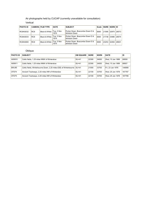
Air photographs held by CUCAP (currently unavailable for consultation)<br />
Vertical<br />
PHOTO ID CAMERA FILM TYPE DATE SUBJECT Scale NGRE NGRN ID<br />
RC8AS032 RC8 Black & White<br />
RC8AS033 RC8 Black & White<br />
RC8AS060 RC8 Black & White<br />
Oblique<br />
Tue, 5 Nov<br />
1974<br />
Tue, 5 Nov<br />
1974<br />
Tue, 5 Nov<br />
1974<br />
Porton Down, Boscombe Down E &<br />
Idmiston Down<br />
Porton Down, Boscombe Down E &<br />
Idmiston Down<br />
Porton Down, Boscombe Down E &<br />
Idmiston Down<br />
9000 21095 32975 28573<br />
9000 21738 33486 28574<br />
9000 23253 32494 28601<br />
PHOTO ID SUBJECT KM SQUARE NGRE NGRN DATE ID<br />
AWM10 Celtic fields, 1.25 miles NNW of Winterslow SU=41 22300 34000 Wed, 15 Jan 1969 89506<br />
AWM11 Celtic fields, 1.25 miles NNW of Winterslow SU=41 22300 34000 Wed, 15 Jan 1969 89507<br />
BWJ95 Celtic fields, Winterbourne Down, 2.25 miles ESE of Winterbourne SU=41 21000 33700 Fri, 23 Jan 1976 146888<br />
CFD74 Ancient Trackways, 2.25 miles NW of Winterslow SU=41 22100 33700 Wed, 25 Jan 1978 167787<br />
CFD75 Ancient Trackways, 2.25 miles NW of Winterslow SU=41 22100 33700 Wed, 25 Jan 1978 167788