

Here's - Surveying & Spatial Sciences Institute
Here's - Surveying & Spatial Sciences Institute
Here's - Surveying & Spatial Sciences Institute

You also want an ePaper? Increase the reach of your titles
YUMPU automatically turns print PDFs into web optimized ePapers that Google loves.
technology&more<br />
A Publication for <strong>Surveying</strong> and Mapping Professionals • Issue 2012-3<br />
Monitoring a Fjord<br />
Watching for Rockslides in Norway<br />
3D for Everyone<br />
Sensors of the Lost Tomb<br />
Seeking Genghis Khan's Burial Place<br />
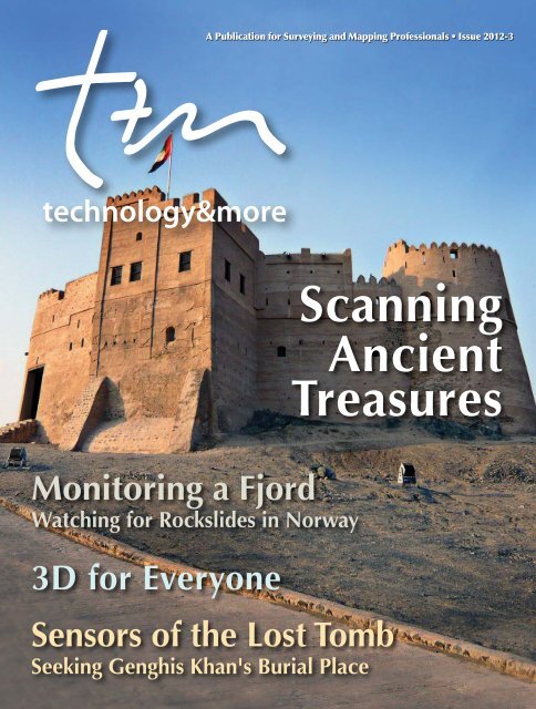
Scanning<br />
Ancient<br />
Treasures
technology&more<br />
technology&more<br />
Welcome to the Latest Issue of Technology&more!<br />
technology&more<br />
Dear Readers,<br />
We hope you enjoy this issue<br />
of Technology&more: the<br />
many articles showcasing<br />
our customers’ world-wide<br />
surveying projects—and our<br />
new magazine design. We<br />
strive to keep each issue of<br />
Technology&more fresh and<br />
exciting and we hope the<br />
new format supports these<br />
Chris Gibson: Vice President<br />
goals. This issue highlights<br />
some fascinating stories: you’ll read about scanning in<br />
the United Arab Emirates (UAE); using high technology<br />
to search for Genghis Khan’s lost tomb in Mongolia;<br />
monitoring potential landslides in Norway’s fjords;<br />
surveying in the Sicilian seas and around a French lake;<br />
monitoring the Panama Canal’s huge construction<br />
project; the innovative uses offered by Trimble®<br />
SketchUp; and many more.<br />
Technology&more seeks to showcase projects around<br />
the world that demonstrate the enhanced productivity<br />
that can be gained through the use of Trimble technology.<br />
We hope that one or more of the articles will provide<br />
useful ideas and information that will benefit you and<br />
your business today—and tomorrow.<br />
If you’d like to share information with Technology&more<br />
readers about your own innovative project, we’d like to<br />
hear about it: just email: Survey_Stories@trimble.com.<br />
We’ll even write the article for you.<br />
And now, enjoy this issue of Technology&more.<br />
Chris Gibson<br />
www.northstarstudio.com<br />
• UAE pg. 2<br />
Scanning Ancient Treasures<br />
• Norway pg. 6<br />
Monitoring Rockslides<br />
• Mongolia pg. 10<br />
Seeking Khan's Tomb<br />
• France pg. 20<br />
French Lake Survey<br />
Published by:<br />
Trimble Engineering & Construction<br />
10355 Westmoor Drive<br />
Westminster, Colorado 80021<br />
Phone: 720-887-6100<br />
Fax: 720-887-6101<br />
Email: T&M_info@trimble.com<br />
www.trimble.com<br />
Editor-in-Chief: Shelly Nooner<br />
Editorial Team: Lea Ann McNabb; Lindsay Renkel;<br />
Omar Soubra; Angie Vlasaty; Heather Silvestri;<br />
Eric Harris; Kelly Liberi; Susanne Preiser;<br />
Christiane Gagel; Anke Becker; Lin Lin Ho;<br />
Bai Lu; Echo Wei; Maribel Aguinaldo;<br />
Stephanie Kirtland,<br />
Survey Technical Marketing Team<br />
Art Director: Tom Pipinou<br />
© 2012, Trimble Navigation Limited. All rights reserved. Trimble, the Globe & Triangle logo, GeoExplorer, Juno,<br />
NetRS, RealWorks and TSC2 are trademarks of Trimble Navigation Limited or its subsidiaries, registered in<br />
United States Patent and Trademark Office. 4D Control, Access, CX, Floodlight, FX, GeoXH, GPScorrect, Integrity<br />
Manager, NetR5, NetR9, Survey Controller, VRS, VRS3Net and VX are trademarks of Trimble Navigation<br />
Limited or its subsidiaries. All other trademarks are the property of their respective owners.
technology&more<br />
Expanding the Canal<br />
Rendering of the new channel at Miraflores. The new Borinquen Dam separates the existing channel and locks (right) from the new channel,<br />
which includes the new locks to handle large ships.<br />
Long recognized as one of the most important engineering<br />
feats in history, the Panama Canal plays a vital role<br />
for global commerce. But the canal is nearly 100 years<br />
old, and its locks and channels are too small to handle today’s<br />
large cargo and container ships. To address the problem, the<br />
Panama Canal Authority (ACP), implemented several projects<br />
to increase the canal’s capacity. One of the largest is the “Third<br />
Set of Locks” project, which will create a lane of new locks and<br />
waterways that can support the larger vessels.<br />
The project plan requires that normal canal operations continue<br />
without disruption. During construction, temporary structures<br />
and cofferdams are used to keep water out of the construction<br />
areas. The new locks and channels require extensive excavation<br />
and earthwork, and many areas call for constant monitoring to<br />
protect workers and equipment from slides or failures on the<br />
steep, muddy slopes. While contractors handle the excavation<br />
and construction, the ACP’s Geodesy Section is responsible<br />
for monitoring the slopes. Led by Geodesy Supervisor Miguel<br />
Narbona, ACP teams conduct regular monitoring surveys of<br />
the land slopes and dams.<br />
ACP installed four Trimble S8 total stations to monitor a channel<br />
near the Gaillard Cut. On the Atlantic side, a fifth total station<br />
monitors an excavation near the new Gatun lock structures.<br />
The instruments are connected to a wireless communication<br />
network, and they are controlled by Trimble 4D Control<br />
software running on a network of computers. The total stations<br />
are installed in steel cages mounted atop steel poles on<br />
the job sites. Although the Panama climate is hot and rainy,<br />
the teams are not concerned with weather protection for the<br />
total stations. They worry more about keeping the equipment<br />
secure, and have designed the instrument housings to prevent<br />
unauthorized access. ACP also conducts periodic campaign<br />
monitoring using a Trimble S8 equipped with a Trimble TSC2®<br />
controller running Trimble Survey Controller software.<br />
The automated instruments monitor a total of more than 120<br />
prisms, taking measurements at 6-hour intervals. Narbona can<br />
manage the entire monitoring system from his desk. He can<br />
set up and control the measurements and make daily analysis<br />
of the operations and results. Narbona uses the deformation<br />
monitoring functions in Trimble 4D Control to make detailed<br />
examination of the data, and he can export data to Excel to<br />
create his own graphs and reports.<br />
Narbona reports that the monitoring system has performed<br />
well, and that measurement results routinely exceed project<br />
requirements for precision. Once construction is complete,<br />
ACP plans to use Trimble integrated optical and GNSS systems<br />
to provide permanent monitoring of the new dams and<br />
structures.<br />
See feature in Professional Surveyor’s October issue: www.profsurv.com<br />
-1- Technology&more
technology&more<br />
A 3D Foundation for<br />
Resource Management<br />
Earlier this year, a group of researchers from Australia’s Royal<br />
Melbourne <strong>Institute</strong> of Technology (RMIT) travelled to Fujairah,<br />
UAE, to take 3D scans of some of the emirate’s archaeological<br />
treasures. This data will help create a baseline for measuring the<br />
effects of climate change on those resources over time.<br />
Fujairah, one of the seven emirates that make up the United<br />
Arab Emirates (UAE), is home to the oldest mosque in the<br />
UAE: Al Bidyah Mosque, built in 1446 of mud and bricks.<br />
This and other archaeological treasures make Fujairah a magnet<br />
for visitors, who generate vital income for the local economy.<br />
The negative effects of climate change threaten these important<br />
resources, but the extent of the threat is not understood—at<br />
least not yet. PhD candidate and Fujairah native Mohamed al<br />
Technology&more<br />
-2-<br />
Hassani—under the supervision of Associate Professor Colin<br />
Arrowsmith, Dr. David Silcock and Mr. Lucas Holden of RMIT—<br />
aims to change that. His doctoral thesis will investigate the<br />
impact and develop a framework for managing the effects of<br />
climate change in Fujairah and other developing regions.<br />
Journey to Fujairah<br />
In January 2012 a team including al Hassani, Arrowsmith,<br />
Silcock and Holden traveled to Fujairah to conduct a proof of<br />
concept for the thesis. They had two objectives: The first was to<br />
acquire 3D point cloud data of internationally significant sites<br />
as the basis for monitoring and future research. The second,<br />
motivated by earlier research that identified local expertise as<br />
an important factor in effective resource management, was to<br />
introduce techniques for terrestrial laser scanning to local staff.
Together with the Fujairah Tourism and Antiquities Authority,<br />
the team identified five key sites for gathering spatial data: the<br />
Al Bidyah Mosque, the Al Fujairah and Al Bithna forts, the Al<br />
Wuraya wadi (a dry river bed) and Al Aqah beach.<br />
Scanning the Fort<br />
January weather in Fujairah is mild, with an average daytime<br />
temperature of 25° C (77° F). But for the non-native researchers<br />
from RMIT, the expedition was still “like something out of an<br />
Indiana Jones movie…and a young surveyor’s dream,” as Silcock<br />
describes it. The mountainous region created an extraordinary<br />
backdrop as the team learned to operate their advanced instruments—including<br />
the <strong>Institute</strong>’s own Trimble CX 3D scanner<br />
system—often in extreme conditions. “We were glad we took<br />
our Trimble equipment,” says Silcock. “You just know it’s going<br />
to work, even coated in dust after a sandstorm.”<br />
The team faced plenty of challenges, not least of which was<br />
the absence of survey marks and survey infrastructure, including<br />
geodetic quality GPS. To compensate for the missing<br />
UTM (WGS84) coordinates, the team had to use two Trimble<br />
Juno® GPS receivers on a baseline at each site. Simultaneous<br />
observations were stored for later processing to bring the local<br />
coordinate system onto datum for georeferencing.<br />
Scanning began with the 400-year-old Al Fujairah fort, a large<br />
building with a perimeter of over 140 m (459 ft) and a wall<br />
height of up to 15 m (49 ft). Due to the size of the fort, the team<br />
had to move the Trimble CX frequently to capture every detail<br />
of the building’s exterior; six external setups were used at an average<br />
spacing of 38 m (125 ft). The team used the target-target<br />
registration technique, so each setup required a minimum of<br />
three overlapping targets in each scan. Some targets were<br />
temporarily attached to the building, some external targets<br />
were mounted on tripods, and others were tribrach-mounted<br />
ground marks.<br />
Trimble Access field software running on a Trimble Tablet<br />
Rugged PC was used to control the scanner and gather<br />
point cloud data. This data (a total of 11,036,000 3D points<br />
scanned) was then processed in Trimble RealWorks®<br />
software, which stitched together the consecutive point<br />
clouds gathered from each setup to form a unified single<br />
point cloud. The cloud was then tied to a local coordinate<br />
system set up by the surveying team, using permanent<br />
ground marks for ongoing monitoring. One internal setup<br />
captured the interior of the fort; it was registered later using<br />
cloud-to-cloud registration in Trimble RealWorks.<br />
-3- Technology&more
Impressed by the scanner’s ability to collect data to<br />
millimeter precision even at distance, the team’s Authority<br />
colleagues asked to make this precision the project’s<br />
minimum standard for cultural buildings. The sites were<br />
therefore scanned at 1.0 cm resolution, with station setups<br />
averaging about 1–1.5 hours. These higher resolutions led to<br />
longer than normal scan times and enormous data sets that<br />
created some management challenges; even so, Authority<br />
staff was delighted by the results, which were observable in<br />
real time on their Trimble Tablet (and even more impressive<br />
when processed and viewed in Trimble RealWorks). “The local<br />
team was extremely enthusiastic,” said Silcock. “And they<br />
weren’t shy about operating the Trimble equipment, which<br />
was robust and easy to learn.”<br />
Building Relationships for the Future<br />
Over the course of the project, the RMIT team noted opportunities<br />
to help Fujairah acquire additional skills and tools<br />
for resource management. They also saw the potential to<br />
map the entire emirate, recording the locations of important<br />
sites and following up with high-precision scanning and<br />
surveying. “Originally, our plan was to simply collect 3D<br />
scans and train local staff in the technology,” says Silcock. “But<br />
the trip also became an ongoing, in-depth information ex-<br />
Technology&more<br />
-4-<br />
change with our Fujairah colleagues about general mapping<br />
and resource management.”<br />
With all five Fujairah sites scanned—23 individual scans in<br />
total—the project delivered enough data for more than a<br />
year’s worth of processing and analysis. Unlike a commercial<br />
provider, the RMIT team shared all data with the Authority at no<br />
cost to the emirate; the Authority interacted with the data via<br />
Trimble RealWorks Viewer software. When the team presented<br />
the final project to His Highness the Fujairah Crown Prince<br />
Mohamed Bin Hamad Al Sharqi, the prince was impressed by<br />
both the data itself and the tremendous potential it represents<br />
for Fujairah.<br />
RMIT also stands to benefit from its cooperation and datasharing<br />
with Fujairah as the relationship creates opportunities<br />
for further research, as well as the development of education<br />
and training by RMIT in Fujairah. It also extends RMIT’s international<br />
reach. Most importantly, however, this collaboration<br />
significantly advances the original goal: to develop a framework<br />
for measuring the impact of climate change on vulnerable<br />
archaeological resources in developing regions.
technology&more<br />
technology&more<br />
High-Level Opportunity<br />
technology&more<br />
Every year, Australia’s coal industry produces more than 320 million tons<br />
of thermal and hard coking coal. The country ranks fourth in global coal<br />
production, and its coal industry employs over 31,000 people. Facing<br />
constant demand for lower costs and increased production, Australia’s<br />
coal mines continuously seek ways to streamline their operations. As new<br />
technologies emerge, one of the most important improvements has come<br />
from an industry insider.<br />
In 2006, Matthew McCauley was a mining manager in New South Wales. McCauley<br />
understood the importance of survey data. The mine needed current, accurate information<br />
for everyday mining operations as well as mine planning. But McCauley’s<br />
survey resources were often occupied surveying for mine production, making it<br />
difficult to procure data needed for engineering and planning. As a result, McCauley<br />
and many other Australian mine managers faced similar predicaments: forward<br />
planning was suffering, as was long-term productivity.<br />
McCauley saw an opportunity. He developed a business plan to provide mines<br />
with aerial survey data, and formed a new company, Atlass (Australia) Pty Ltd. To<br />
meet the mines’ needs, McCauley needed to provide survey information that was<br />
up-to-date, detailed and accurate. McCauley procured a Trimble Harrier mapping<br />
system, which he installed in a Cessna U206G aircraft. The Harrier system<br />
integrates flight management, aerial camera and laser scanning with GNSS and<br />
inertial positioning sensors. The system also provides software for processing and<br />
analysis on the images and scanning data.<br />
As owner and operator of aircraft, aerial survey equipment and processing<br />
facilities, Atlass controls the entire workflow of data acquisition, processing<br />
and delivery. The operation enables McCauley to guarantee his mining<br />
clients will receive their data within three days—or it’s free. Much of that<br />
commitment comes from his confidence in the Trimble Harrier system. “It’s<br />
a very mature system,” McCauley said. “It does everything we need and the<br />
hardware is extremely robust. Our first unit has done more than 2,000 hours<br />
now. It’s five years old, and I reckon it will still be going in another five.”<br />
One of Atlass’ customers is Xstrata Coal. Xstrata conducts comprehensive<br />
monthly surveys of its mines, and working with Atlass allowed Xstrata to<br />
produce detailed coal stockpile surveys and mine models. Xstrata mine<br />
surveyor Andrew Buchan said they get a reliable turnaround on airborne<br />
surveys. “We’re capturing more data and there’s so much more we can do<br />
with it. In effect our use of data has expanded ten-fold,” Buchan said.<br />
Atlass has grown quickly. The company now operates Trimble Harrier 56/G3<br />
and Harrier 68i systems and three aircraft. With these resources, Atlass can fly<br />
more than 250 hours each month and run a true 7-day operation. There is a<br />
growing demand for Atlass services beyond the mining sector. It is finding<br />
new opportunities in power-line surveys, town planning, engineering design,<br />
coastal monitoring, erosion monitoring and vegetation assessment.<br />
See feature in POB's April issue: www.pobonline.com<br />
-5- Technology&more
technology&more<br />
More than 50 years ago, a Norwegian farm boy left<br />
his family home near the shore of a remote fjord to<br />
climb the 40-percent slope towering above. Nearly<br />
853 m (2,800 ft) up the rocky face, he discovered a crack<br />
the size of his small fist. Fast-forward to today: that crack is<br />
more than 15 m (48 ft) wide—and the entire slope is slowly<br />
accelerating towards a potential rockslide.<br />
This boy’s discovery set off a chain of events that resulted<br />
in an ambitious plan utilizing state-of-the-art research and<br />
technologies to detect and provide an early warning of the<br />
potential failure of the steep rocky slope.<br />
Evidence of rockslides in ancient and modern history is<br />
readily visible along the fjords. The most notable example<br />
happened in 1934 near the far end of the same fjord complex;<br />
a rock slide about the same size as this potential slide<br />
created a “tsunami” wave resulting in the deaths of 34 local<br />
residents and property damage representing tens of millions<br />
in adjusted dollars.<br />
Evaluating Potential Rock Slides<br />
Scientific studies of past slides and other active slide areas<br />
have provided detailed models of the behavior of such<br />
slopes leading up to such failures. According to the studies,<br />
Technology&more<br />
Monitoring Rockslides on<br />
Norway's Fjords<br />
-6-<br />
a slope like this one would accelerate from the current few<br />
centimeters per year to several centimeters per day beginning<br />
about two weeks prior to the failure.<br />
This is a predictable rock slide, nearly 600 m (1,969 ft) wide,<br />
more than 1 km (3,280 ft) long and with some parts close<br />
to 200 m (656 ft) deep. It is estimated that this large of a<br />
rockslide plunging into the fjord could generate run-up<br />
waves as high as 90 m (295 ft) and endanger villages in the<br />
narrow waterways.<br />
The sheer size of the potential slide and its proximity to local<br />
towns and villages gave rise to calls within the Norwegian<br />
government and local communities to find ways to provide<br />
as much warning time as possible. With legacy methods,<br />
movements would be noticeable by visual and audible<br />
cues alone only in the final days before a slide. What was<br />
needed was a comprehensive, high-precision monitoring<br />
system capable of detecting the more subtle movements to<br />
provide “earlier” warning.<br />
A Bold Plan<br />
The Norwegian government and the local Åkneset (Åknes)/<br />
Tafjord Early-Warning Center enlisted the geo-monitoring<br />
company Cautus Geo AS to provide on-site instrumentation,
data management and the early warning system. Their plan<br />
was to employ multiple monitoring components to interface<br />
with a new early-warning system being constructed for<br />
the region. Cautus Geo key project engineer Lars Krangnes<br />
considered the inherent challenges of constructing these<br />
multiple systems in such a remote and steep environment<br />
and harsh climatic conditions. “Every person and each piece<br />
of equipment had to be transported by helicopter,” noted<br />
Krangnes. “Instruments, fuel, and supplies—even the bags<br />
of concrete needed to construct a control building had to<br />
be flown in.” The instrumentation ranged from simple extensometers<br />
(dubbed “crackmeters”) to measure the expansion<br />
of the upper crack to the sophisticated Trimble S8 robotic<br />
total station monitoring dozens of targets over the entire<br />
slope to the sophisticated Trimble NetR9 GNSS network<br />
tracking the movement of the slope.<br />
Sophisticated Monitoring Tools<br />
“Our S8 total station stands behind a bay window in the<br />
observation building above the slope” says Krangnes. “The<br />
building is climatically controlled and also houses generators,<br />
key data processing and communications equipment.”<br />
Together with the Trimble S8 total stations, Trimble 4D Control<br />
software is used to control the total station and analyze its<br />
data. “The robotic total station continuously cycles through<br />
observations of 30 prism targets over the entire slope, doing<br />
in minutes what would have taken days for a survey crew,”<br />
Krangnes adds. “It can detect subtle movements ranging<br />
from the current several centimeters-per-year rates to the<br />
expected centimeters-per-day movement that would happen<br />
prior to a collapse.”<br />
The next major system for tracking the movement of the<br />
slope is a network of GNSS units. There are 10 Trimble NetR9<br />
GNSS units onsite that have their positions compared every<br />
15 minutes, 4 hours and 12 hours to two GNSS units placed<br />
on stable ground offsite. This GNSS-monitoring system can<br />
resolve positions every second to high accuracies by utilizing<br />
geodetic-grade GNSS antennas and receivers as well as<br />
Trimble 4D Control software, a suite of “motion engines” that<br />
apply multiple advanced mathematical algorithms in realtime<br />
to the GNSS observations.<br />
The GNSS network is currently one of the most important<br />
and trusted monitoring systems at Åknes and provides<br />
high-accuracy 3D data. “The frequency and accuracy of the<br />
3D results, along with the robustness and stability of the<br />
network makes the system very well suited for a challenging<br />
site like Åkneset,” says Krangnes.<br />
Other lower-precision surface monitoring systems are employed,<br />
but to monitor the subsurface conditions Krangnes<br />
-7- Technology&more
employed “geophones that listen to the moans and groans<br />
of the subsurface rock that is under the tremendous pressures<br />
of the downhill slide.” He adds, “We also drilled deep<br />
boreholes for strain gauges and tilt meters extending below<br />
the rock layer to stable bedrock below.” Krangnes summarizes<br />
the surface and subsurface instrumentation as being<br />
“like the monitors in a hospital’s Intensive Care Unit (ICU);<br />
each reports individual readings that collectively give a total<br />
picture of the health of the slope.”<br />
Managing the Warning System<br />
Robust communications links interface with the Åknes/<br />
Tafjord Early Warning Center. “Based on experience from<br />
other rockslides and measured yearly movement for this<br />
site, a theoretical acceleration diagram has been defined,”<br />
Krangnes says. “From these figures, alarm levels have been<br />
defined to evaluate emergency plans for the region.” Under<br />
certain scenarios, and as early as two weeks prior to a<br />
predicted failure, decisions might be made to suspend shipping<br />
in the fjord and issue warnings to local residents. In<br />
the final days before a predicted collapse, evacuation orders<br />
may be issued for some communities. Even in the worstcase<br />
scenario, as little as five minutes warning would enable<br />
residents to seek high ground or shelter.<br />
New Tools for Monitoring Hazards Worldwide<br />
There are similar sites in other parts of the world where these<br />
types of technologies are being applied to similar hazards.<br />
Examples include plate tectonics (earthquake) monitoring<br />
in Sichuan China and in the Pacific Northwest of the U.S.;<br />
Technology&more<br />
-8-<br />
volcanoes in Alaska and Papua; a tsunami detection system<br />
on India’s offshore islands; mudslides in New Zealand and<br />
Italy; dams and bridges in Washington State; and open pit<br />
mines in South Africa. These new tools contrast with legacy<br />
systems by detecting actual movement with much higher<br />
precision, with less reliance on derived or modeled results.<br />
With the availability of high-precision, real-time monitoring<br />
systems like Trimble VRS and Trimble VRS3Net App networks<br />
and Trimble Integrity Manager, comprehensive trending and<br />
true warning systems for localized geophysical events may be<br />
achieved.<br />
The Norwegian Fjords project represents a great step forward<br />
in the evolution of monitoring and warning systems for<br />
catastrophic slope failures and may be applied to other<br />
geophysical phenomenon.<br />
“This project is not a pilot or an experiment,” says Krangnes.<br />
Instead, he adds, “This project is designed as an active<br />
monitoring and early warning system using multiple and<br />
redundant instrumentation to assure success.”<br />
In summary of this groundbreaking initiative, Norway’s Minister<br />
of Local Government and Regional Development Magnhild<br />
Meltveit Kleppa stated, “Through the comprehensive monitoring<br />
and safety systems in the Åknes-Tafjord project, the<br />
threat to people’s life and health is substantially reduced.”<br />
See feature article in American Surveyor's April issue:<br />
www.amerisurv.com
technology&more<br />
Round Numbers<br />
3D Scanning provides precise information on a hydrocarbon<br />
storage tank in France.<br />
Facilities in the petroleum industry are subject to strict<br />
controls and measures to ensure safety and proper operation.<br />
This is certainly the case with the large hydrocarbon<br />
storage tanks belonging to the group TOTAL, one of the world’s<br />
largest petroleum and gas companies.<br />
As part of the inspection process, TOTAL’s TEC/GEO (Technology/<br />
Survey), department conducts measurements to determine<br />
deformation of the tanks, which can be as much as 100 m (328 ft)<br />
in diameter with heights ranging between 15 and 25 m (50 and<br />
82 ft). Because of the size of the tanks and the need for precise<br />
measurements, TEC/GEO initiated a test project to develop techniques<br />
for measuring and analyzing the shape of the tanks using<br />
the Trimble FX 3D scanner. The primary goal was to evaluate<br />
the precision of the measurements obtained by the 3D scanner<br />
and compare them with traditional measurements made using<br />
a total station.<br />
The test project was carried out on storage tank T7 at TOTAL’s<br />
plant in Lacq, France in April 2011. “Besides the verticality of its<br />
walls, it was important to know the roundness of the tank,” said<br />
Arnaud Vidal, engineer-topographer at TEC/GEO. “The tank has<br />
a floating roof, which rises and falls according to the amount<br />
of hydrocarbon in the tank. So we must ensure that it cannot<br />
be blocked at any point—that is, the tank must be truly round<br />
and not oval.”<br />
It took only a half-day to collect the data. Vidal’s team set up<br />
the Trimble FX at ground level only a few meters away from<br />
the tank, making a total of eight full-height scans to capture<br />
the entire structure. The scanning was conducted to obtain a<br />
resolution of approximately one point every 2 cm (0.8 in) on<br />
the walls of the tank.<br />
In the office, Vidal's team used Trimble RealWorks software to<br />
register the scans into a single point cloud. He also compared<br />
the scanning results with data collected using a Trimble VX<br />
spatial station, which the team used to collect points and vertical<br />
profiles around the tank.<br />
The scanner and resulting point cloud allowed TOTAL<br />
surveyors to measure cross sections and vertical profiles at<br />
any location on the tank. By contrast, measurements using<br />
a conventional total station can collect vertical profiles at<br />
only a few locations around the tank. “Deformations may<br />
exist between the vertical profiles measured using the total<br />
station, and we would not detect them,” Vidal explained.<br />
“We are very interested in using the Trimble FX because of<br />
the great density of the points it provides. This enables us<br />
to measure elements between the vertical profiles that are<br />
not covered by the total station.” Based on the test results,<br />
Vidal has recommended the use of scanning on existing<br />
and newly-constructed storage tanks.<br />
See feature in Professional Surveyor's June issue: www.profsurv.com<br />
-9- Technology&more
technology&more<br />
technology&more<br />
Dr. Albert Yu-Min Lin shows the expedition's high-resolution imagery to colleagues.<br />
Sensors of the Lost Tomb<br />
Dr. Albert Yu-Min Lin’s approach to archeology is groundbreaking<br />
because he isn’t actually breaking ground.<br />
Indeed, he and his exploration team are on a quest<br />
to locate the lost tomb of Genghis Khan without exhuming a<br />
single blade of grass.<br />
“Unlike traditional archeological missions, our goal is not to<br />
dig,” explains Lin, a research scientist and National Geographic<br />
Emerging Explorer at the University of California San Diego’s<br />
(UCSD) Center of Interdisciplinary Science for Art, Architecture<br />
and Archaeology. “Instead, we are using technology to do our<br />
digging through an exhaustive, non-invasive survey of Genghis<br />
Khan’s homeland.”<br />
Lin first went to Mongolia in 2005 with only one handheld GPS,<br />
one change of clothes and a backpack of questions about his<br />
Chinese lineage—his grandfather said his family had “influence”<br />
from the North. It was then, while living with a family<br />
of horsemen, that Lin’s intrigue, and eventual obsession with<br />
Genghis Khan—a man who has been greatly misunderstood,<br />
says Lin—began.<br />
In 2008 he launched the three-year Valley of the Khans project<br />
with the goal to use non-invasive technology to excavate sites<br />
of interest, without disturbing the ground nor local traditions,<br />
to help resolve the enigma of both the man and his final resting<br />
place—a 785-year-old mystery. The first full-scale expedition to<br />
the region was in July 2009, followed by two more exhaustive<br />
surveys in 2010 and 2011.<br />
Each expedition has taken them to the Forbidden Zone in the<br />
Kentii mountain range, 100 miles northeast of Ulaanbaatar,<br />
Technology&more<br />
-10-<br />
where dirt roads can wash away overnight, mosquitoes are<br />
monstrous, home is a traditional yurt—a circular, wood-frame<br />
structure covered by wool felt—and the temperature can<br />
change 30 degrees in less than 30 minutes.<br />
With each visit, technological tools have helped them narrow<br />
their searches in this vast area, particularly in 2010, when they<br />
could download in real time the GPS coordinates of potential<br />
man-made anomalies tagged on satellite imagery by “citizen<br />
scientists.” This non-invasive approach, in fact, guided them to<br />
one of their most promising study sites. Where they observed<br />
artifacts, they applied 3D electro-resistivity tomography (ERT),<br />
magnetometry and ground-penetrating radar (GPR) to reveal<br />
any subsurface features.<br />
They soon realized that it would be critical to also have an<br />
accurate 3D topographical map so that they could spatially<br />
and historically connect all of their findings and sites of interest.<br />
So in advance of the 2011 expedition, Lin secured a Trimble<br />
VX spatial station, a precision measurement sensor that integrates<br />
video capture, 3D scanning and survey-grade total<br />
station functionality, to help lay out a main study site and<br />
collect location points for every artifact found in between.<br />
<strong>Spatial</strong> Context<br />
Each morning, Jeremiah Rushton, a PhD candidate at UCSD<br />
and designated “Trimble Man,” hoisted the survey equipment<br />
onto his back and hiked up the mountainside to the 100-m by<br />
30-m (300 x 100 feet) site. After setting control, Rushton and<br />
another team member methodically moved through the site<br />
in a grid pattern, collecting a point every square foot to ensure<br />
there were no data gaps, and also taking measurements of
Clockwise from top left: Dr. Lin's group traveled throughout Mongolia seeking the lost tomb; Andrew Hunyh (left) and Jeremiah Rushton (right) taking<br />
data points of identified artifacts; UCSD's StarCAVE virtual reality system allows team members to immerse themselves in the high-resolution imagery.<br />
objects discovered at the site. Operating the unit remotely<br />
using Trimble Access field software on a Trimble TSC2 controller,<br />
all data was uploaded to a laptop for nightly processing,<br />
producing near-real-time mapping information to help them<br />
better plan the next day’s strategy. The team logged about<br />
1,000 data points a day for 10 consecutive days—that is, when<br />
they weren’t outrunning thunder and lightning storms.<br />
“One day a storm developed out of nowhere and it got so<br />
cold and wet so fast that I almost threw up,” recalls Rushton.<br />
“Lightning strikes were fast approaching so we had to quickly<br />
pack up and sprint down the trail, which had already turned<br />
into a river. We just made it back to our yurt in time.”<br />
Indeed, the frequent rain required much ingenuity from the<br />
team to protect their high-tech instruments. For the survey<br />
equipment, they affixed a rice bowl over the instrument’s<br />
prism as a protective “hat” from moisture and used a solar<br />
panel as a canopy to protect the Trimble VX unit. Despite the<br />
challenging environment, the team successfully mapped the<br />
entire site, including 200 individual trees.<br />
Lin also used the survey technology in another innovative<br />
way—tracking the GPR instrument in real time. Having<br />
difficulty mapping the GPR data to the surface, Lin proposed<br />
applying the automatic-turning ability of the spatial station<br />
to georeference a GPR survey in real time.<br />
It worked. Attaching the prism to the radar antennas, the Trimble VX<br />
recorded a point every half second as the GPR was pushed along<br />
the ground. That georeferenced GPR data could then be overlaid<br />
on the topographical map to add further spatial and historical<br />
depth to their findings and better focus their exploration.<br />
A View Anew<br />
After returning from the field, Lin and his team integrated their<br />
myriad data layers with the survey-based topographical map,<br />
and built a 3D seamless visualization of the entire site, enabling<br />
Lin and his team to see the area with new eyes.<br />
“The topographical map allowed us to clearly see the<br />
anomalies that we had been studying, both on the surface<br />
and below, and their relationships,” says Lin. “Equally important<br />
is that it confirmed our study footprint as well as gave us<br />
new areas of focus. It’s insight we could not have gleaned<br />
without the accurate map.”<br />
So does all of this verification mean Lin’s team has found<br />
the lost tomb of Genghis Khan? For now, Lin is keeping that<br />
answer buried as deep as the tomb itself. There is still much<br />
information to process and much data to share with his Mongolian<br />
colleagues. What is clear, however, is that whatever the<br />
outcome, Lin will not be seen with a shovel in hand digging up<br />
the presumed location.<br />
See feature article in POB’s September issue: www.pobonline. com<br />
-11- Technology&more
technology&more<br />
technology&more<br />
technology&more<br />
Technology&more<br />
Gathering a<br />
Flood of Data<br />
Floodwaters inundate a Bundaberg neighborhood. Advance warnings and evacuation plans prevented injury and loss of life.<br />
The rain in December 2010 was not unexpected. Every<br />
year, northeastern Australia experiences six months of<br />
dry weather followed by a long rainy period known as<br />
the “Big Wet.” But this season’s Big Wet would be wetter than<br />
normal. The state of Queensland endured the soggiest December<br />
on record, with new record rainfall totals at more than 100<br />
locations. The rains overwhelmed rivers and drainage systems,<br />
producing weeks of widespread flooding. Sitting astride the<br />
Burnett River on Australia’s east coast, the city of Bundaberg<br />
was hit by two major floods in three weeks.<br />
Bundaberg residents were first alerted to the potential for flooding<br />
after weeks of heavy rain fell across the Burnett watershed.<br />
Additional rain in late December caused the river to rise rapidly,<br />
and on December 30 it peaked at 7.92 m (26.0 ft) above the<br />
Australian Height Datum (AHD)—a level not seen since 1942.<br />
As the flood approached, emergency crews activated disaster<br />
plans and evacuated hundreds of residents.<br />
The city’s surveyors looked beyond the looming devastation.<br />
They viewed the floods as an opportunity to capture data that<br />
could assist with flood modeling and prediction, emergency<br />
management and town planning. To do so, they needed to<br />
measure locations of the peak flood levels, as well as the date<br />
and time of the peaks.<br />
The Regional Council Responds<br />
The Bundaberg Regional Council manages surveying, mapping<br />
-12-<br />
and engineering for the region’s roads, drains and infrastructure.<br />
In 2008, the Council decided to establish a permanent geodetic<br />
framework to support the region’s positioning needs. Partnering<br />
with Geosciences Australia (the government body that manages<br />
Australia’s spatial data infrastructure), the Council installed<br />
a Trimble NetR5 reference station at the Bundaberg airport.<br />
Working with a repeater installed on a hill overlooking the city,<br />
the reference station could deliver RTK corrections over a wide area.<br />
In planning their work during the flood, the surveyors set<br />
a goal to capture as much data as possible along the road<br />
networks and rivers. The surveyors needed high data density<br />
in Bundaberg’s urban areas, and uniform coverage along the<br />
length of the Burnett towards Paradise Dam.<br />
Resources, however, were limited; many staff members were<br />
away on Christmas/New Year holidays, and the flood surveys<br />
needed to cover more than 50 km 2 (19 mi 2 ). The solution: Get<br />
the community involved. Through local media and websites, the<br />
region’s citizens were asked to mark the flood’s highest extents<br />
on their properties. Residents set markers indicating high water<br />
locations, often writing the time data on lath or stakes in the<br />
ground. In the days after the flood’s peak, Council surveyors measured<br />
flood high water marks on each property and indicators<br />
such as flood debris in trees and fences. Most of this work was<br />
done with two Trimble R8 GNSS receivers using RTK corrections<br />
from the airport base station. The data was collected in Trimble<br />
TSC2 controllers running Trimble Survey Controller software.
Five days after the first flood had dropped below the “minor flood<br />
level” of 3.5 m (11.5 ft) AHD, an additional 300 mm (12 in) of rain<br />
fell onto the waterlogged Burnett watershed. Still reeling from the<br />
initial surge, Bundaberg received a new set of flood warnings.<br />
While gathering data on the first flood was valuable, Bundaberg<br />
Regional Council’s Manager of Design Dwayne Honor knew that<br />
a time stamp for water levels would be crucial to create accurate<br />
flood models. So survey crews switched their focus to concentrate<br />
on the second flood. Using data collected from the first<br />
flood, teams visited key locations at regular intervals to gather<br />
3D data of flood water levels.<br />
Once again, assistance came from the broader community.<br />
The Council asked residents between Bundaberg<br />
and Paradise Dam, 100 km (63 miles) upstream, to record<br />
changes in water levels over time. The Council also engaged<br />
an aerial surveying firm to capture data upstream of the<br />
city as the flood approached. The second flood peaked in<br />
Bundaberg at 5.76 m (18.9 ft) AHD on January 13, 2011.<br />
After the flood subsided, Council surveyors conducted bathymetric<br />
work to augment the land and aerial surveys. A boat<br />
was equipped with a SonarMite Echo Sounder connected<br />
via Bluetooth to a TSC2 Controller and Trimble R8 GNSS rover.<br />
A second Trimble R8 GNSS receiver served as a mobile base<br />
station, broadcasting RTK corrections from the riverbank. The<br />
teams surveyed approximately 113 km (70 mi) of the river,<br />
collecting cross sections at an average interval of 200 m (650<br />
ft). The results of the bathymetric surveys allowed the Council<br />
to assess the post-flood shape of the Burnett riverbed. The<br />
information was also passed into Tuflow software for use in<br />
developing 1D/2D flood models. Three months later, the fieldwork<br />
was complete. The dataset has been vital in consultants’<br />
work in calibrating the new flood study.<br />
“The floods gave us an extremely hectic couple of weeks,”<br />
Honor said. “When you’re under pressure like that you can’t<br />
afford to have issues with the technology or bugs to sort out<br />
with the gear. The Trimble equipment allowed us to plan our<br />
work efficiently and gave us certainty that we could capture<br />
what we needed within the time frames available.”<br />
The assistance from local residents proved invaluable. Several<br />
homeowners suffered great losses, yet they found time to<br />
meet and talk to Council staff. While it might not have been<br />
considered at the time, the residents’ aid in marking flood<br />
levels leaves a legacy of high-quality data. Because the<br />
surveyors were able to collect so much data, the Council and<br />
community can have high confidence in the results of the<br />
flood modeling. It will work to everyone’s benefit by helping<br />
to mitigate flooding from the next “Big Wet.”<br />
See feature article in American Surveyor's September issue:<br />
www.amerisurv.com<br />
A Bundaberg surveyor measures the high water mark on a roadway.<br />
Teams made periodic visits to key locations to monitor the flood’s progress.<br />
Council surveyors conduct post-flood bathymetric surveys on the Burnett<br />
River. Sonar and GNSS positions provide cross-section data for riverbed<br />
analysis and flood modeling.<br />
Teams inspect a road washout. Floodwaters reached the highest levels<br />
since 1942.<br />
-13- Technology&more
technology&more<br />
Technology&more<br />
Trimble SketchUp —<br />
3D for Everyone<br />
An Easy, Consistent Workspace for 3D Design,<br />
Visualization and Information Exchange<br />
Designers and engineers are most creative when they<br />
can focus on a problem, not on the tools they use to<br />
solve it. That’s the premise behind Trimble SketchUp, a<br />
drawing and modeling tool created to deliver the benefits of 3D<br />
design and modeling to the broadest possible audience. SketchUp<br />
accomplishes this by combining an exceptionally easy user<br />
interface with rigorous computations and a vast library of<br />
user-built 3D models and components. Since its inception,<br />
SketchUp has focused on being an easy, approachable tool.<br />
Because SketchUp is so user-friendly, a higher percentage of<br />
people will use it, which can translate directly to an increase in<br />
an organization’s productivity.<br />
When a new user sits down with SketchUp, the first impression<br />
reinforces the software’s reputation for ease of use. But this<br />
is no lightweight drawing program. SketchUp operates on a<br />
powerful 3D modeling engine that combines engineeringlevel<br />
precision with sophisticated tools to create and manage<br />
the objects, groups and attributes that make up a 3D design.<br />
The system uses its close ties to Google Earth to provide basic<br />
functionality for georeferencing. And, through the Trimble<br />
3D Warehouse, users have no-cost access to thousands of 3D<br />
models of buildings, construction equipment and just about<br />
anything you can imagine.<br />
In a traditional CAD approach, designs begin in 2D and then<br />
are built up into 3D. By contrast, everything in SketchUp starts<br />
as a true 3D model. Because the designer operates in 3D from<br />
the outset, the transition from 2D to 3D is removed, taking<br />
with it the setbacks that commonly occur at that stage of the<br />
process. Issues related to 3D fit and feasibility can be solved<br />
early in the design process. Once the 3D design is settled, then<br />
SketchUp can produce 2D plan and layouts as needed.<br />
Because SketchUp provides an easy way to see and manipulate<br />
a design in 3D, the design-feedback-revision cycle is quicker.<br />
-14-<br />
A SketchUp model for planning and development. The buildings can<br />
be modeled with engineering precision<br />
A plan shows existing parcels adjacent to a planned structure. Surveygrade<br />
data can add information on the surrounding properties and<br />
improvements.
Combining SketchUp models with images from Google Earth,<br />
designers can create street level and aerial views of their project and<br />
surrounding features.<br />
A 3D model of a building construction site includes plans for vehicle<br />
access and laydown areas. The model can be set to depict the site at<br />
various stages of construction.<br />
For example, a surveyor and architect can collaborate to optimize<br />
a building’s location on a particular site. The architect<br />
can incorporate changes and push the model back to the<br />
surveyor, who provides related layout information. This sharing<br />
can go through multiple iterations until all design concerns are<br />
settled—before the project begins.<br />
SketchUp in the Geo-Referenced World<br />
SketchUp’s capabilities for modeling and visualization fit well<br />
with the geospatial community, and the software is being rapidly<br />
adopted by positioning professionals. Let’s look at examples<br />
in cadastral, building construction and site management.<br />
Over the years, cadastral information has transitioned from<br />
paper media to digital vector media, and again to objectbased<br />
media. Cadastral surveyors can use SketchUp’s dynamic<br />
components to create parcels and entities to manage data for<br />
cadastral and land information systems. Instead of delivering a<br />
piece of paper or CAD file, cadastral surveyors create intelligent<br />
data objects that can feed directly into land information systems.<br />
By developing a collection of individual, georeferenced<br />
3D models, land information systems can depict and manage<br />
large regions with exceptional detail and precision.<br />
In building design and construction, SketchUp serves as an<br />
important front-end tool. Brian Unger, an associate architect at<br />
Roth Sheppard Architects in Denver, Colorado, uses SketchUp<br />
to work through options during the concept and pre-design<br />
phases, including walk-through videos and concept images.<br />
“Visualization is incredibly important,” Unger said. “Anytime you<br />
can have a 3D model in front of your clients or consultants, it<br />
will be beneficial because of the quick understanding.” Building<br />
models can be placed onto 3D terrain models to visualize<br />
how a structure will fit the existing ground. Using SketchUp<br />
in conjunction with Google Earth, designers can access terrain<br />
information and insert proposed buildings into sites.<br />
Construction site logistics requires management of materials,<br />
machines and personnel on a rapidly changing worksite. Project<br />
teams can use SketchUp to create virtual 3D construction<br />
sites to communicate construction processes. By creating<br />
different scenes based on various stages of construction, planners<br />
can test the sequencing and movement of equipment<br />
and materials while communicating the potential impact on<br />
the surrounding community. For example, consider a site on<br />
which multiple buildings are under construction. Project managers<br />
can depict the buildings in different stages, and test to<br />
see that trucks and excavators can move around the site once<br />
the buildings are in place. The Trimble 3D Warehouse contains<br />
models of most heavy equipment, so it is easy to download a<br />
specific bulldozer to make sure it fits between the buildings.<br />
Accelerating the Trend to 3D Information<br />
Geospatial professionals utilize powerful tools that deliver rich,<br />
highly detailed information. Until now, the ability to leverage<br />
and share that information has relied on sophisticated, often<br />
complex software systems. But with SketchUp, that paradigm<br />
changes. SketchUp enables users across a broad range of<br />
skill levels to comfortably access data collected by advanced<br />
positioning and information systems. As a result, it’s possible<br />
to utilize and share information in ways never possible before.<br />
Geospatial professionals are quickly trending away from using<br />
2D paper or PDF plans to exchange site and survey information.<br />
3D provides much richer information, and SketchUp gives geospatial<br />
professionals a tool to develop and share the 3D data.<br />
And while clients recognize the value of 3D models produced<br />
by design and visualization systems, they often are not willing<br />
to invest in expensive systems just to visualize a model created<br />
by their consultants. SketchUp provides the ability to create,<br />
share and use 3D models in a common, cost-effective medium.<br />
Trimble’s integration and extension of SketchUp and 3D data<br />
is expected to make SketchUp stronger and more accessible<br />
to a new, broader range of uses. It’s poised to deliver on the<br />
promise of 3D information for everybody.<br />
See feature article in Professional Surveyor's September isssue:<br />
www.profsurv.com<br />
-15- Technology&more
technology&more<br />
technology&more<br />
A Safe CALM Survey<br />
technology&more<br />
Technology&more<br />
-16-<br />
The petrochemical industry has devised an ingenious<br />
method for loading and offloading ocean-going<br />
tankers in a safe and cost-effective manner: floating<br />
buoys, secured to anchors on the sea floor, that act as small<br />
oil or gas terminals.<br />
These Catenary Anchor Leg Mooring (CALM) buoys enable the<br />
massive tankers to remain in open water during the exchange.<br />
The fluid is piped from the refinery to the buoy, and the ship<br />
attaches hoses to the buoy to take it on board; the same process<br />
works in reverse. This approach eliminates the need to extend<br />
docking facilities into deeper water, saving money and resources.<br />
It is critical to ensure that CALM buoys are properly anchored.<br />
Any error in the placement of the anchor points can render<br />
the buoys dangerously vulnerable to high winds and rough<br />
seas, creating hazardous transfer conditions and jeopardizing<br />
a significant financial investment. In 2010, concerned over<br />
possible deviation from existing project plans, a Sicilian<br />
petrochemical complex commissioned an independent survey<br />
of the piles in order to solidify plans to secure a CALM buoy<br />
in the company’s operational hub on the Santa Panagia Bay.<br />
The Customer<br />
Italy’s Syracuse Industrial Triangle covers a large area in eastern<br />
Sicily and plays an important role in the economy of the region.<br />
First started in the 1950s, the Syracuse complex of refineries,<br />
chemical plants and gasification facilities is one of Europe’s<br />
largest petrochemical installations. Over the years, it has<br />
been expanded by many allied industries, such as builders of<br />
offshore oil rigs.<br />
Much of the region’s oil and gas is shipped by sea, and large<br />
tankers are common in the area. As an alternative to docking<br />
at piers for loading and unloading, the ships use CALM buoys<br />
for transferring fluid to and from the refinery. Each buoy is<br />
attached to metal chains, which are anchored to piles driven<br />
into the seabed. Connected to the chains, the buoy is securely<br />
held in the center of the area bounded by the piles.<br />
The Right Method<br />
The surveying and engineering company Archilab di Paolo<br />
Zappulla & C was selected to determine the planimetric<br />
position of several existing CALM piles driven into the Santa<br />
Panagia Bay seabed. The primary goal of the survey was to<br />
determine the exact position of each pile, using a dual system<br />
of WGS84 and Roma40 coordinates (Roma40 is Italy's geodetic<br />
system, and refers to the astronomical data of 1940), making it
possible to compare the actual location of the piles (which the<br />
client believed inaccurate) against earlier plan data.<br />
Most of the Syracuse piles are visible from shore and could have<br />
been measured from shore using total stations; however, the<br />
number of observations required and the difficulty of placing<br />
targets at sea prompted Archilab to use GPS for the work instead.<br />
The team used Sicily’s real-time network (VRS Sicilia) to provide<br />
RTK correction data. Data from the network was received by<br />
mobile telephone and used via the RTCM 3.0 protocol.<br />
The VRS Sicilia network, which uses Trimble VRS technology to<br />
provide centimeter-level precision, includes 20 Trimble NetRS®<br />
GPS reference stations located throughout Sicily. It allows the<br />
engineers to perform any type of survey on a regional level,<br />
using a single system of coordinates common for all users. Surveyors<br />
can also download data from the reference stations for<br />
use in post-processing. VRS Sicilia can be used in real time and<br />
by any type of GPS application, including marine construction<br />
and operations along the Sicilian coast. By using the VRS Sicilia<br />
real-time network, the Archilab team eliminated the need for<br />
an RTK base station and could provide results directly in the<br />
WGS84 system.<br />
The Survey<br />
The CALM buoy will be anchored with five chains approximately<br />
300 m (980 ft) long connected to five corresponding piles.<br />
Since the survey was to be conducted at sea, the Archilab team<br />
used a boat to get close to the piles to be surveyed. The work<br />
team consisted of a diver, an on-board engineer and the boat’s<br />
captain. Weather conditions were ideal during the survey, with<br />
bright sun and a calm sea.<br />
The work began and ended on land. To confirm accuracy,<br />
the team initialized a Trimble R6 GPS receiver with VRS Sicilia,<br />
and then measured an IGM95 control point at the beginning<br />
and end of the survey. The IGM95 network is a basic geodetic<br />
network built in 1992 by the Italian Istituto Geografico Militare<br />
(Military Geographical <strong>Institute</strong> or IGM). All IGM95 control points<br />
were established using GPS.<br />
Once the team arrived at a pile in the bay, the diver left the<br />
boat to stand on the pile and position the Trimble R6 at<br />
different points on the pile. These points corresponded with<br />
the pile’s center and also with the heads of the fixing bolts of<br />
each sealing cover. On four of the five piles, the team used RTK<br />
to mark, code and measure 10 points. Because the fifth pile had<br />
no sealing cover, only four points were measured, corresponding<br />
with the horizontal and vertical axes of the pile.<br />
Using a Trimble TSC2 controller running Trimble Access software,<br />
the on-board engineer catalogued the data and acquired<br />
the information necessary to determine the planimetric posi-<br />
tion of each point. The controller used a wireless connection to<br />
communicate with the Trimble R6. The entire survey, including<br />
work to verify control, was completed in a single day.<br />
A Successful Project<br />
The final data was prepared in the WGS84 and Roma40 coordinate<br />
systems. The engineers built a table of WGS84 geographic<br />
coordinates and exported them directly from the Trimble TSC2<br />
controller. An IGM software program, based on a grid containing<br />
the area of operations, transformed the WGS84 coordinates<br />
into the Roma40 coordinate system.<br />
Archilab delivered the data to the client, who then computed<br />
the differences between the earlier surveys and Archilab’s<br />
data. The results showed that the piles had not been placed<br />
in the design position, with differences of 24 to 57 m (80<br />
to 190 ft). Archilab’s survey also revealed that the radius of<br />
the rough circle of piles that will surround the buoy was not<br />
regular; this irregularity could affect the stability of the buoy,<br />
which is important for safety during the oil and gas transfer<br />
process. Thanks to the work of Archilab and GPS, the operators<br />
now have accurate information for safely and efficiently<br />
managing future CALM operations at Santa Panagia Bay.<br />
Top: Tankers connect to CALM buoys to upload oil or gas. The Santa<br />
Panagia Bay CALM buoy will be similar to the one shown here.<br />
Bottom: A survey crew determines the position of existing CALM piles.<br />
-17- Technology&more
technology&more<br />
technology&more<br />
technology&more<br />
NMSS's Dave and Arnold Bansemer control the Gatewing X100 from the Trimble Tablet Rugged PC in Namibia.<br />
<strong>Surveying</strong> an open-pit mine can be a hazardous undertaking.<br />
In order to obtain accurate volume measurements,<br />
it is necessary to pick up edges—known in the industry<br />
as “toes and crests”—as well as heaps. These are important<br />
features, since they provide a way to verify the current shape of<br />
a mine; but in light of increasingly stringent safety regulations<br />
and penalties, some companies refuse to let the surveyor get<br />
too close to such areas. <strong>Surveying</strong> the site from the air is an<br />
effective solution to this challenge.<br />
It’s also a cost-effective solution. In fact, Namibian Mining<br />
Survey Services (PTY), Ltd. (NMSS), estimates that using an<br />
unmanned aerial system (UAS) can save more than 95 percent<br />
in mobilization costs, i.e., bringing in resources from outside the<br />
country to conduct a lidar/photogrammetric survey. Believing<br />
UAS to be an important part of the future of surveying, NMSS<br />
had been investigating the technology for some time, and a<br />
recent project provided the perfect opportunity to try it out.<br />
NMSS selected the Gatewing X100 for the job based on a<br />
demo at a platinum mine—the results closely tracked those of<br />
a previous lidar survey—and the firm’s positive experience with<br />
Trimble. “All my other equipment is Trimble, and the backup<br />
and support I receive from Optron is outstanding,” says NMSS’s<br />
Dave Bansemer. “I had no hesitation in purchasing the X100.”<br />
The Project<br />
The project was to survey a portion of Abenab Mine, a vanadium-lead<br />
mine owned by South West Africa Company and<br />
Technology&more<br />
Aerial Survey<br />
-18-<br />
in Namibia:<br />
Safe and<br />
Cost-effective<br />
located just west of Tsumeb. The mine had been closed in the<br />
1960’s, but feasibility studies were underway to see if it would<br />
be viable to reopen the operation. Mine management needed<br />
to know volumes of all waste and tailings dumps, slimes dams<br />
and open pit excavations. The main pit was roughly circular,<br />
about 60 m (197 ft) deep and 120 m (394 ft) across. Two smaller<br />
pits were covered in fairly thick vegetation but had enough<br />
ground showing to provide an accurate shape.<br />
The survey area was approximately 100 hectares. The flying<br />
height was set at 150 m (492 ft) in order to provide a ground<br />
separation distance of 5 cm. Ground control points (GCPs) were<br />
constructed from 1 m (3.28 ft) lengths of masonite cut into 10<br />
cm wide strips; painted bright red, the strips were designed to<br />
provide 20x2 pixel coverage on the images. A total of 10 GCPs<br />
were set out in strategic positions covering a wide range of<br />
elevations, with points on top of the dumps, on undisturbed<br />
ground level and in the pits. The points were fixed from existing<br />
control on the UTM34S coordinate system, by fast static techniques<br />
using the firm’s Trimble R6 GPS systems.<br />
Launching the X100<br />
Based on the Gatewing training received, basic photogrammetry<br />
principles and a few trials, NMSS determined that 9 am–3<br />
pm was the best time to fly in order to avoid shadow. The flight<br />
area, including a previously surveyed area that would serve as a<br />
check, covered 140 hectares. Assuming favorable wind conditions,<br />
NMSS expected to cover the area on a single flight.
Arriving on site at 7 am, Bansemer started setting out the GCPs<br />
while his colleague performed the fast static survey. By 10 am<br />
all GCPs had been placed and fixed. Having identified a suitable<br />
take-off and landing spot (a farm road), they proceeded<br />
through the pre-flight and flight checklist and then launched<br />
the X100 at 11 am. After completing the flight in around 35<br />
minutes, with some turbulence at the 150 m flying altitude,<br />
the X100 landed safely, albeit short of the goal, in an open area.<br />
Once the data was downloaded, the team returned to Tsumeb<br />
to begin the processing. They started with the post-processing<br />
of the GCPs, and then moved to the coordinates obtained in<br />
the photo-control identification process. NMSS used Gatewing<br />
Stretchout Pro software for the photogrammetrical processing.<br />
After specifying the coordinate system and identifying the<br />
GCPs, the number crunching began; the processing ran for<br />
around seven hours before the final point cloud and orthomosaics<br />
were created. The mean horizontal error was 3 cm and the<br />
vertical error was 9 cm, well within the error budget.<br />
Impressive Results<br />
The first check was to see if all areas had been covered. NMSS<br />
then checked the point cloud against the previous survey, and<br />
was impressed with the results. The tie-in was perfect. Some<br />
gaps in the point cloud seemed to correspond with tree canopy<br />
areas; to ensure complete accuracy, the team resurveyed a few<br />
areas using the Trimble VX spatial station.<br />
NMSS learned some important lessons from using this<br />
cutting-edge technology, which Bansemer lists for the<br />
benefit of future users:<br />
• Make sure you have enough control. It is sometimes difficult<br />
to place your control points exactly in the corners<br />
of your flight and one in the center, as the actual flight is<br />
influenced by wind direction and the shape of the flight<br />
may change accordingly. Put down more points than<br />
recommended.<br />
• Make sure that your ground control point size is relevant to<br />
your flying height. You will not be able to identify a 10 cm<br />
wide strip if you fly at 300 m (484 ft).<br />
• Check the completeness of the job before you leave the<br />
area.<br />
• Make sure there is sufficient area for a safe landing. (Bansemer<br />
recommends at least a 300 m strip, taking obstacles<br />
into account in the event of a short landing.)<br />
”We needed a way to conduct surveys quickly and accurately,<br />
with minimal risk to health and safety,” concludes<br />
Bansemer. “The Gatewing X100 has fulfilled that requirement<br />
nicely. We are very happy with the performance and<br />
results from the X100.”<br />
From the top: The X100 prepares for flight. Aerial image of the X100 survey.<br />
Dave and Arnold Bansemer prepare the X100 for the survey.<br />
-19- Technology&more
technology&more<br />
Technology&more<br />
A Unique<br />
Measuring Campaign<br />
Working in a prestigious study program, Reine Stoffels,<br />
a Geomatics Masters’ student from the Universiteit Gent<br />
(Belgium), participated in a combined hydrographic and<br />
topographic survey of a reservoir in France. Along with gaining<br />
practical knowledge, Stoffels took photographs of the<br />
project and entered several in the Technology&more Photo<br />
Contest; the image on the far right was the winner in the last<br />
(2012-2) issue. Here’s the story behind the picture.<br />
Every summer, sailing and water sport enthusiasts<br />
come to the Lac de Vassivière in central France. One<br />
of France’s largest lakes, Vassivière is a 1,000-hectare<br />
(2,500-acre) reservoir constructed to provide electricity to<br />
the Limousin region. Opened in 1950, the lake feeds water<br />
to the Mazet hydroelectric station owned by Electricité de<br />
France (EDF).<br />
For several years, EDF had requested a detailed survey of the<br />
lake to better monitor the lake’s volume and water level. In 2010<br />
the European Union (EU) gave the green light for a three-year<br />
ERASMUS Intensive Program (IP) to do the work. Launched in<br />
1987, the ERASMUS Program supports education and training<br />
programs throughout the world. The IP brings together<br />
students and teachers from higher-education institutions in at<br />
least three participating countries.<br />
The project at Vassivière was sponsored by Boskalis, a<br />
Dutch company specializing in dredging, earth-moving<br />
and maritime infrastructure. For this IP, students came from<br />
the Ecole Nationale Supérieure de Techniques Avancées<br />
Bretagne (ENSTA-Bretagne) in Brest, France, Belgium’s<br />
Universiteit Gent (UGent) and Germany’s HafenCity Universität<br />
Hamburg (HCU). In addition to its significant size and<br />
-20-<br />
complexity, the Lac de Vassivière project became the first<br />
hydrography and geomatics course to be organized at the<br />
European level.<br />
Obstacle Course<br />
The survey objective was to deliver a detailed digital elevation<br />
model of the Vassivière reservoir. Data collection would<br />
involve topographic and hydrographic surveying, with positioning<br />
data to be developed using Trimble GNSS receivers<br />
and total stations. To serve as the basis for GNSS measurements,<br />
the university team installed two base stations near<br />
the lake. The stations were tied to the France Lambert93<br />
coordinate system.<br />
“It was a captivating experience,” says Reine Stoffels. “The measurement<br />
campaign started on October 30, 2011, and ended<br />
on November 10th. The lake was divided into 20 zones, with<br />
five groups of students surveying four zones each. Ideally, the<br />
groups would spend 2.5 days per zone. However, 2011 was an<br />
exceptionally dry year and the water was low, resulting in a 5 to<br />
6 m (16 to 20 ft) band of sand around the entire lake. To gather<br />
the needed data required more topographical surveying<br />
than was originally planned, and topographic measuring<br />
would take longer than the hydrographic soundings originally<br />
scheduled for the now-dry areas.<br />
The students conducted intensive surveys on the lake’s<br />
western side—and to a lesser degree the eastern side. The<br />
most important permanent features around the lake (the<br />
dam, jetties, etc.) were surveyed in detail. Over an area of 120<br />
hectares (300 acres), the team used a combination of total<br />
stations and GNSS to measure approximately 62,000 points.<br />
The work went quickly; the team averaged approximately
1,000 points per group, per day. Project requirements called<br />
for average point density of one point every 5 m (16 ft),<br />
and the teams achieved that goal. The actual point density<br />
varied based on terrain conditions, with lower density along<br />
beaches and difficult-to-access woodland strips, and higher<br />
density in critical areas such as docks, piers and related<br />
structures. In addition, the working range for the total stations<br />
changed with terrain conditions around the lake. This<br />
range could vary from a couple dozen to hundreds of meters<br />
of free visibility.<br />
To complete the lake’s 3D model, the “dry” measurements<br />
were combined with bathymetric data and measurements<br />
made with terrestrial laser scanners. The experimental<br />
margin for error of the bathymetric data—used as basis for<br />
combining the other data sets—was 5 to 10 cm (2 to 4 in).<br />
The teams needed to meet this criterion for the topographic<br />
measurements; Stoffels reported that the Trimble GNSS and<br />
total stations delivered data well within the requirements. To<br />
verify accuracy, cross-data validation tests were carried out<br />
in areas by measuring points with different equipment and<br />
from different reference points.<br />
Workload pressure remained high for 10 days. “We had breakfast<br />
at half past six in the morning and continued working until<br />
the sun went down,” said Stoffels. “Then we transferred the<br />
data from the instruments to our laptops and checked the<br />
data to eliminate any errors. We then sent the data to the<br />
central server so that we could go to sleep around 11 o’clock.”<br />
Everyone started the project in a good mood, but by the end<br />
of the first week it was clear that none of the groups would<br />
complete their assigned zones. At that point, the teams<br />
decided to redivide the zones and schedule a second<br />
measurement campaign in 2012.<br />
Student Insight<br />
One of the IP’s objectives was for hydrography and geomatics<br />
students of the three universities to exchange as much<br />
knowledge and experience as possible. “We cooperated like an<br />
international multidisciplinary team,” says Stoffels. “We received<br />
guidance from the scientific staff of the three universities,<br />
which proved necessary because the project required very<br />
specific knowledge. In addition, the measurement data from<br />
very different instruments had to be combined together, and<br />
that introduced some interesting challenges.”<br />
For the measurement campaign the student teams used a<br />
multi-beam sonar, side-scan sonar, laser scanners, inertial<br />
motion units, various total stations and GNSS with RTK. “The<br />
project provided us with a unique opportunity to work with<br />
professional equipment,” says Stoffels. “The partner universities<br />
had instruments from different manufacturers. The oldest<br />
equipment was barely automated, which did not help our<br />
productivity, but it did provide insight into the underlying<br />
measurement methods and processes.”<br />
While Stoffels worked with an array of equipment from ENSTA,<br />
UGent and HCU, she found she preferred the Trimble equipment,<br />
including the Trimble R6 and R8 GNSS receivers and<br />
and the Trimble S6 DR300 robotic total station, all connected<br />
to Trimble Survey controllers. “I found the Trimble equipment<br />
to be very user-friendly,” said Stoffels. “Due to the clear menu<br />
structure and the logical workflow, users can get up to speed<br />
quickly with the instruments and software.”<br />
-21- Technology&more
technology&more<br />
Under the Towering Oak Trees:<br />
GNSS Performance Enhanced<br />
with Trimble Floodlight<br />
technology&more<br />
technology&more<br />
To improve the accuracy of its GIS maps, Louisiana’s St.<br />
Charles Parish purchased its own GNSS equipment but<br />
needed improved performance beneath the parish’s<br />
towering oak trees. Both productivity and accuracy were<br />
immediately improved when they upgraded to the Trimble<br />
GeoExplorer® 6000 series of mapping GNSS handhelds<br />
with Trimble Floodlight technology.<br />
The last straw for Louisiana’s St. Charles Parish came<br />
when an underground water pipeline burst beneath<br />
a busy street. Traffic had to be diverted as the water<br />
continued to spill out onto the pavement. An hour passed<br />
before personnel from the Waterworks Department found<br />
the shutoff valve and stopped the deluge. The delay was<br />
caused by a faulty map that incorrectly showed the valve’s<br />
location on the other side of the street. Enough was<br />
enough. Things had to change.<br />
The St. Charles Waterworks Department is responsible for<br />
maintaining, repairing and upgrading the parish’s network<br />
of above- and below-ground water pipelines. The Public<br />
Technology&more<br />
-22-<br />
Works Department manages the storm protection and<br />
drainage infrastructure, such as catch basins, ditches,<br />
and levees.<br />
As is true for many local government departments, the<br />
Waterworks Department relied on as-built drawings and<br />
sketches supplied by developers and engineering firms to<br />
keep the network of underground water pipes updated in<br />
its GIS. At the time, the parish had no other option because<br />
it lacked internal mapping capabilities.<br />
In 2008, St. Charles created a GIS Office to support mapping<br />
needs of all other parish departments and hired Luis Martinez<br />
to manage it. Fortunately, Martinez had been trained to use<br />
GNSS technology for GIS data collection in his previous position.<br />
He convinced the parish it would be cost-effective to<br />
invest in mapping- and survey-grade GNSS equipment and<br />
train personnel to use it as part of their daily operations.<br />
”The first personnel we trained were the Waterworks and<br />
Public Works crews,” said Martinez.
Productivity Booster<br />
The GIS Office maintains a parish-wide, Internet-accessible<br />
GIS comprised of layers for nearly all departments. Aside<br />
from Public Works, the Waterworks Department has the most<br />
rapidly evolving geospatial data layers in the parish. With new<br />
water pipes being installed or old ones being replaced, the<br />
Waterworks infrastructure map is constantly in flux. Handheld,<br />
GNSS-based, GIS data collection units were seen as the ideal<br />
solution for keeping layers accurate and up to date.<br />
Waterworks crews experienced problems with accuracy when<br />
working beneath the stately oak trees that line many parish<br />
residential streets. The oak canopies deflect and partially block<br />
GNSS signals from reaching the receivers, impairing productivity<br />
through a phenomenon called satellite shadow. This same signal<br />
deflection problem often faces mapping crews working among<br />
tall buildings in many cities.<br />
Martinez quickly identified the satellite shadow problem<br />
and upgraded the parish GNSS equipment to the Trimble<br />
GeoExplorer 6000 series. These handheld GIS mapping devices<br />
come equipped with the unique Trimble Floodlight capability<br />
that overcomes the productivity-reducing effects of satellite<br />
shadow without sacrificing accuracy. The technology accomplishes<br />
this through a combination of multi-constellation (GPS<br />
and GLONASS) positioning, advanced tracking algorithms, and<br />
altitude-constrained positioning.<br />
Waterworks personnel onsite at every excavation project<br />
began using Trimble GeoExplorer 6000 GeoXH handhelds<br />
running Esri ArcPad data collection software. As new pipe is<br />
laid in the ground, the handheld devices are used to map the<br />
location and depth with submeter accuracy before the pipe is<br />
buried. Crews use pull-down Esri ArcPad menus on the touch<br />
screen to collect key descriptive data relating to each asset,<br />
such as the size and composition of the conduit. Additionally,<br />
locations of other important items such as shut-off valves are<br />
mapped onto the GIS layer with the same precision.<br />
“Before Floodlight, we could only get a strong signal from<br />
about six satellites, depending on the canopy,” said Martinez.<br />
“Even with differential correction, only 60 percent of our points<br />
achieved the desired 15-cm (6-in) accuracy, while most of the<br />
rest were off by as much as three feet or more.”<br />
Today, with the Trimble GeoExplorer 6000 handheld, Waterworks<br />
crews routinely lock onto 12–13 satellites and achieve<br />
15-cm (6-in) accuracy for 85 to 90 percent of all points in<br />
feature-mapping projects. In the field, they use a Bluetooth<br />
connection and cell phone to access differential correction<br />
points published on the Internet by a local continuously operating<br />
reference station (CORS). Points are corrected in real time<br />
with Trimble GPScorrect extension for Esri ArcPad software<br />
running on the handheld.<br />
Floodlight allows us to maintain mapping accuracy,” explained<br />
Martinez, “and it pays for itself by saving time for field crews.<br />
Without the technology, crews had to measure offset positions<br />
to get out from under the trees.”<br />
This wasn’t necessary once they obtained the Trimble GeoExplorer<br />
6000 handhelds. Martinez said that measuring an offset<br />
could take two to five extra minutes to collect a single position,<br />
compared to just 15 seconds when occupying the feature<br />
itself. In addition, Floodlight technology allows the receiver to<br />
maintain satellite lock when it is put back in the vehicle for the<br />
drive to the next collection point. This also shaves several more<br />
minutes off each point collection.<br />
“Waterworks is so pleased with the GeoExplorer 6000s that they<br />
plan to buy two just for their department,” said Martinez. “They<br />
will integrate the mapping units with electromagnetic linelocating<br />
devices to map the pipes already buried underground.”<br />
The St. Charles GIS has never been more up-to-date and<br />
information-rich than it is now. But Martinez sees room to grow<br />
and is considering expanding the use of Trimble GIS mapping<br />
equipment to other departments, including Planning and<br />
Zoning. Inspectors from this department will soon carry integrated<br />
GIS mapping devices that enable them to document<br />
code violations in writing with time- and location-stamped<br />
photographs.<br />
-23- Technology&more
technology&more<br />
technology&more<br />
technology&more<br />
PHOTO CONTEST<br />
Once again, our Facebook fans have spoken: after our editors chose the top four photos, the Facebook Trimble Survey<br />
fans (www.facebook.com/TrimbleSurvey) chose the top two winners. First place—and a Trimble 3-in-1 all-weather<br />
jacket—goes to “Somewhere Over the Vineyard,” which received the most Facebook fan votes. Second place—and an<br />
iPod Shuffle—goes to “Road to Heaven.” See the other options, which are also prize winners, and be part of the action: check<br />
out Trimble Survey Division on Facebook for the next issue’s photo contest contenders.<br />
Somewhere Over the Vineyard<br />
In 2010, New Zealand’s Landlink, Ltd., won a New Zealand <strong>Institute</strong><br />
of Surveyors Gold Award of Excellence for its work on<br />
the Bishops Vineyard, Ohau Village project in Horowhenua—<br />
and we received this beautiful image! The project features a<br />
master-planned layout of four “precincts,” a large vineyard and<br />
two areas of preserved historic stone buildings. “Our surveyors<br />
were involved in the project from urban design, resource<br />
consents, engineering design and land transfer surveys right<br />
through to the end of the title process,” said Landlink Registered<br />
Professional Surveyor Paul Turner. “The judges agreed<br />
that Bishops Vineyard demonstrates the surveyor’s skill in managing<br />
a project from start to finish.” Landlink used the Trimble<br />
R8 GNSS system for topographic surveys, set out of roading<br />
and infrastructure and final survey for titles. "The Trimble R8 is<br />
a versatile and robust piece of equipment that is indispensable<br />
for efficient land development projects," Turner said.<br />
Road to Heaven<br />
Professional Land Surveyor Vickus van Dyk of South Africa’s Van Dyk & Associates, Inc., took this breath-taking image while performing<br />
a road survey using the Trimble M3 total station. Van Dyk’s crew was working just outside of Hermanus on a mountain<br />
overlooking the Atlantic Ocean and part of the Hemel-en-Aarde (Heaven and Earth) valley. While van Dyk’s assistant Hilton<br />
Hamman took a back sight to one of the Trig beacons on another mountain, van Dyk noticed the photo op: “Taking only one<br />
photo wouldn't have captured the view so I took a panoramic photo,” he says. “Hermanus is one of the most popular tourist<br />
destinations in South Africa and one of the best whale-watching spots in the world. <strong>Surveying</strong> in an area like this beats any<br />
normal 9-to-5 office job.”
technology&more<br />
technology&more<br />
technology&more<br />
A Day in the Life<br />
If you had to outline a day in your life, what would it<br />
look like?<br />
From sunrise to sunset and beyond, geospatial<br />
professionals around the world lead some pretty<br />
exciting lives. And we want to highlight yours.<br />
Whether you’re a surveyor in a large city or the back<br />
country, whether you work alone or as part of a crew, on<br />
spectacular construction projects or setting up cadastre<br />
in developing countries, tell us about your day—and<br />
we’ll share it with others.<br />
This new feature will run in each issue for as long as we<br />
find fun and exciting professionals to highlight. You'll<br />
gain publicity for you and your firm, as well as a Trimble<br />
prize—plus the excitement of seeing your professional<br />
life both in print and on Facebook!<br />
Just send a brief paragraph highlighting what your day<br />
looks like with your name, contact info and a photo or<br />
two to Survey_Stories@trimble.com—and we’ll do the rest.<br />
Check back here in the next issue to see what YOUR day<br />
may look like. We look forward to hearing from you—and<br />
spotlighting your “Day in the Life.”
technology&more<br />
technology&more<br />
Photo Contest<br />
Enter Trimble’s Technology&more<br />
Photo Contest!<br />
The winners of the Trimble Photo Contest receive<br />
Trimble prizes and the photos are published in<br />
Technology&more. This issue's first place winner<br />
is the Somewhere Over the Vineyard photo<br />
from Paul Turner of New Zealand’s Landlink, Ltd.<br />
See top winners on page 24. Send your photo<br />
at 300 dpi resolution (10 x 15 cm or 4 x 6 in) to<br />
Survey_Stories@trimble.com. Make sure you<br />
include your name, title and contact information.<br />
To subscribe to Technology&more for free, go to: www.trimble.com/t&m.<br />
You can also send an email to: T&M_info@trimble.com.<br />
You can also view Technology&more online at www.trimble.com/t&m.<br />
Optionally, copy, fill in and fax this form to us.<br />
Fax (U.S.) +720 887 6101<br />
Fax (EU) +49 61 42 2100 140<br />
Fax (Asia) +61 7 3216 0088<br />
q Please send more information about the<br />
following product:<br />
q Please send more information about the<br />
following article:<br />
q Please include me on the mailing list of<br />
Technology&more.<br />
q Please call.<br />
q My feedback on Technology&more:<br />
Company<br />
Name<br />
Street<br />
City<br />
State / Province<br />
Zip Country<br />
Phone<br />
