Kelly Shannon, Vinh and Cantho, Vietnam - nrg4sd.org
Kelly Shannon, Vinh and Cantho, Vietnam - nrg4sd.org
Kelly Shannon, Vinh and Cantho, Vietnam - nrg4sd.org

You also want an ePaper? Increase the reach of your titles
YUMPU automatically turns print PDFs into web optimized ePapers that Google loves.
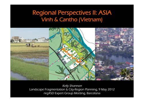
Regional Perspectives II: ASIA<br />
<strong>Vinh</strong> & <strong>Cantho</strong> (<strong>Vietnam</strong>)<br />
<strong>Kelly</strong> <strong>Shannon</strong><br />
L<strong>and</strong>scape Fragmentation & City-Region Planning, 9 May 2012<br />
nrg4SD Expert Group Meeting, Barcelona
<strong>Vietnam</strong> = ‘dat nuoc’ (earth & water)<br />
1490 map of <strong>Vietnam</strong> under Le Dynasty
<strong>Vinh</strong>: a prototypical <strong>Vietnam</strong>ese city<br />
230,000 inhabitants; 300km south of Hanoi
layered narratives<br />
feudal administrative & military center
educed to rubble<br />
extensively bombed in Second Indochina War due to location at head of HCM Trail
ebuilt – an imported vision<br />
‘City of Socialist Man’ – Quang Trung Housing Estate
contested territories<br />
post ’doi moi’ sprawl
incomplete water network<br />
city has turned its back on its rivers
City as Sponge<br />
completed network – irrigation + transport
alternating strips of mass <strong>and</strong> void<br />
National Highway 1A <strong>and</strong> urbanization one-house deep
isl<strong>and</strong>s in a sea of green<br />
1.5 to 1.7m difference in low/high l<strong>and</strong>
City as Sponge<br />
consolidated l<strong>and</strong> fill
high l<strong>and</strong> habitation<br />
western edge protected; eastern public platform edge
high l<strong>and</strong> isl<strong>and</strong> – exp<strong>and</strong>ed public realm<br />
wooden platforms for small public buildings + rice drying
productive_scape<br />
interlocking eco-systems
City as Sponge<br />
protective / productive vertical l<strong>and</strong>scapes
econfigured water_scape<br />
<strong>Vinh</strong> River as new front for <strong>Vinh</strong> Market
l<strong>and</strong>-use city-making<br />
approved masterplans to 2020
City as Sponge<br />
builds on rationality hidden in reality
informal market space provision & public water tranport<br />
market area on <strong>Vinh</strong> River
Lam Riverfront development<br />
underutilized prime l<strong>and</strong>
iverfront city expansion<br />
mixed development & flood field
prime l<strong>and</strong> developed<br />
a new urban facade
climate change effects in <strong>Vietnam</strong> ‘potentaily catastrophic’, primarily in deltas<br />
impact of 1-5m SLR; impact on urban extent [World Bank, 2007; OSA, 2010]
climate change: predicted flooding & saline intrusion<br />
<strong>Cantho</strong> in the heart of the Delta [OSA/ WIT/ LATITUDE, 2010]
‘river water’ & ‘canal creek’ civilization + canal highways in the <strong>Vietnam</strong>ese Mekong<br />
Cho Gao (Duperre) Canal built in 1875 Musee national des Arts asiatiques-Guimet
feudal as found l<strong>and</strong>scape of the Mekong Delta<br />
a frontier region in SE Asia’s ‘age of commerce’ (Anthony Reid) [OSA, 2010]
engineered interplays of rivers & canals<br />
taming the <strong>org</strong>anic geometry with Cartesian order [OSA, 2010]
urbanizing the territory<br />
60 km apart (flow velocity & sedimentation load of the water causality) [OSA, 2010]
high-l<strong>and</strong>/ low-l<strong>and</strong> cultivation<br />
sea of wet-paddy cultivation with spindly orchard l<strong>and</strong>scape morphology [OSA, 2010]
diversification of crops across the territory <strong>and</strong> fruiting seasons<br />
<strong>Cantho</strong>’s agri- aqua- culture logics [A. De Nijs, L. Nagels, ASRO, 2009]
new challenges: massive urbanization & new connections<br />
l<strong>and</strong>-use planning & infrastructure development [SIUP masterplan]
existing condition<br />
low-l<strong>and</strong> paddy, high-l<strong>and</strong> orchards & urbanization [OSA, WIT, LATITUDE, 2010]
existing agricultural masterplan to 2020<br />
[<strong>Cantho</strong> Department of Agriculture; OSA/WIT/LATITUDE, 2010]
proposed revision to agricultural masterplan to 2030<br />
[OSA/WIT/LATITUDE, 2010]
urban transformations – existing, if trends continue, proposed<br />
balance of cut-<strong>and</strong>-fill in principle [OSA, WIT, LATITUDE, 2010]
Urban areas – Omon coupled with highway, not Hau River<br />
[OSA/WIT/LATITUDE, 2010]
Built platforms: different configurations <strong>and</strong> heights for urbanization<br />
[OSA/WIT/LATITUDE, 2010]
Civic spine: new public armature (transport, water management, public equipment)<br />
[OSA/WIT/LATITUDE, 2010]
Water network: quantity (flood, retention, drainage & irrigation) & quality (purification)<br />
[OSA/WIT/LATITUDE, 2010]
Green network: Hau river park, <strong>Cantho</strong> linear park, civic spine tree planting<br />
[OSA/WIT/LATITUDE, 2010]
Urban/l<strong>and</strong>scape structure<br />
[OSA/WIT/LATITUDE, 2010]
Transportation plan: public transport networks<br />
water taxi <strong>and</strong> tramway [OSA/WIT/LATITUDE, 2010]
translation of OSA/ WIT/ LATITUDE plan into Vientamese l<strong>and</strong>use plan<br />
all major principles of plan maintained [SIUP, 2010]
civic spine _ north<br />
[OSA/WIT/LATITUDE, 2010]
civic spine _ south<br />
[OSA/WIT/LATITUDE, 2010]
existing urbanization<br />
high-l<strong>and</strong> fill (2-3 m above lowl<strong>and</strong> paddy) [OSA, 2012]<br />
0 1 2 5km
existing urbanization, orchards & roads<br />
high-l<strong>and</strong> fill (2-3 m above lowl<strong>and</strong> paddy) [OSA, 2012]<br />
0 1 2 5km
proposed urbanization (consolidation into isl<strong>and</strong>s)<br />
high-l<strong>and</strong> fill (2-3 m above lowl<strong>and</strong> paddy) [OSA, 2012]<br />
0 1 2 5km
proposoed urbanization, orchards & roads<br />
high-l<strong>and</strong> fill (2-3 m above lowl<strong>and</strong> paddy) [OSA, 2012]<br />
0 1 2 5km
ECOLOGY as an <strong>org</strong>anizing principle for<br />
URBAN DESIGN