Demarcation of Water Basins on National Level - EIS
Demarcation of Water Basins on National Level - EIS
Demarcation of Water Basins on National Level - EIS

Create successful ePaper yourself
Turn your PDF publications into a flip-book with our unique Google optimized e-Paper software.
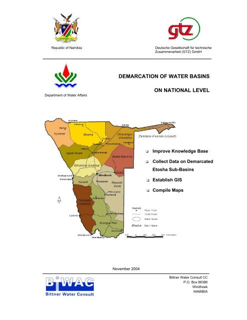
Republic <str<strong>on</strong>g>of</str<strong>on</strong>g> Namibia Deutsche Gesellschaft für technische<br />
Zusammenarbeit (GTZ) GmbH<br />
Department <str<strong>on</strong>g>of</str<strong>on</strong>g> <str<strong>on</strong>g>Water</str<strong>on</strong>g> Affairs<br />
DEMARCATION OF WATER BASINS<br />
November 2004<br />
ON NATIONAL LEVEL<br />
Improve Knowledge Base<br />
Collect Data <strong>on</strong> Demarcated<br />
Etosha Sub-<str<strong>on</strong>g>Basins</str<strong>on</strong>g><br />
Establish GIS<br />
Compile Maps<br />
Bittner <str<strong>on</strong>g>Water</str<strong>on</strong>g> C<strong>on</strong>sult CC<br />
P.O. Box 86386<br />
Windhoek<br />
NAMIBIA
Basin <str<strong>on</strong>g>Demarcati<strong>on</strong></str<strong>on</strong>g> Table <str<strong>on</strong>g>of</str<strong>on</strong>g> c<strong>on</strong>tents i<br />
TABLE OF CONTENTS<br />
1. ANALYSIS AND RANKING OF CRITERIA FOR THE DELIMITATION OF NAMIBIA BASINS..............1<br />
1.1 INTRODUCTION........................................................................................................................................1<br />
1.2 ANALYSIS OF CRITERIA USED FOR THE DELIMITATION OF THE NAMIBIAN BASINS............1<br />
1.3 RANKING OF CRITERIA USED FOR THE DELIMITATION OF THE NAMIBIAN BASINS .............2<br />
2. CRITERIA FOR THE DEMARCATION OF THE 11 WATER BASINS ...........................................................4<br />
2.1 ETOSHA BASIN .........................................................................................................................................4<br />
2.1.1. Physiographic Parameters..........................................................................................................4<br />
2.1.2. Populati<strong>on</strong> Density and Political/Administrative Areas ............................................................4<br />
2.1.3. Infrastructure, Socio-Ec<strong>on</strong>omic and Cultural Units...................................................................5<br />
2.2 CUVELAI (IISHANA) SUB-BASIN...........................................................................................................5<br />
2.2.1. Physiographic Parameters..........................................................................................................5<br />
2.2.2. <str<strong>on</strong>g>Water</str<strong>on</strong>g> Supply and C<strong>on</strong>sumpti<strong>on</strong>................................................................................................5<br />
2.3 NIIPELE-ODILA SUB-BASIN ...................................................................................................................5<br />
2.3.1. Physiographic Parameters..........................................................................................................5<br />
2.3.2. <str<strong>on</strong>g>Water</str<strong>on</strong>g> Supply and C<strong>on</strong>sumpti<strong>on</strong>................................................................................................6<br />
2.3.3. Populati<strong>on</strong> Density and Political/Administrative Areas ............................................................6<br />
2.3.4. Infrastructure, Socio-Ec<strong>on</strong>omic and Cultural Units...................................................................6<br />
2.3.5. Other..........................................................................................................................................6<br />
2.4 TSUMEB SUB-BASIN................................................................................................................................6<br />
2.4.1. Physiographic Parameters..........................................................................................................6<br />
2.4.2. <str<strong>on</strong>g>Water</str<strong>on</strong>g> Supply and C<strong>on</strong>sumpti<strong>on</strong>................................................................................................6<br />
2.4.3. Populati<strong>on</strong> Density and Political/Administrative Areas ............................................................7<br />
2.4.4. Infrastructure, Socio-Ec<strong>on</strong>omic and Cultural Units...................................................................7<br />
2.5 OLUSHANDJA SUB-BASIN......................................................................................................................7<br />
2.5.1. Physiographic Parameters..........................................................................................................7<br />
2.5.2. <str<strong>on</strong>g>Water</str<strong>on</strong>g> Supply and C<strong>on</strong>sumpti<strong>on</strong>................................................................................................7<br />
2.5.3. Populati<strong>on</strong> Density and Political/Administrative Areas ............................................................8<br />
2.5.4. Infrastructure, Socio-Ec<strong>on</strong>omic and Cultural Units...................................................................8<br />
2.5.5. Other..........................................................................................................................................8<br />
2.6 KUNENE BASIN ........................................................................................................................................8<br />
2.6.1. Physiographic Parameters..........................................................................................................8<br />
2.6.2. Populati<strong>on</strong> Density and Political/Administrative Areas ............................................................8<br />
2.6.3. Infrastructure, Socio-Ec<strong>on</strong>omic and Cultural Units...................................................................9<br />
2.7 UGAB-HUAB BASIN.................................................................................................................................9<br />
2.7.1. Physiographic Parameters..........................................................................................................9<br />
2.7.2. <str<strong>on</strong>g>Water</str<strong>on</strong>g> Supply and C<strong>on</strong>sumpti<strong>on</strong>................................................................................................9<br />
2.7.3. Infrastructure, Socio-Ec<strong>on</strong>omic and Cultural Units...................................................................9<br />
2.8 TSONDAB-KOICHAB BASIN.................................................................................................................10<br />
2.8.1. Physiographic Parameters........................................................................................................10<br />
2.8.2. Populati<strong>on</strong> Density and Political/Administrative Areas ..........................................................10<br />
2.9 ORANGE-FISH BASIN ............................................................................................................................10<br />
2.9.1. Physiographic Parameters........................................................................................................10<br />
2.9.2. <str<strong>on</strong>g>Water</str<strong>on</strong>g> Supply and C<strong>on</strong>sumpti<strong>on</strong>..............................................................................................11<br />
2.9.3. Infrastructure, Socio-Ec<strong>on</strong>omic and Cultural Units.................................................................11<br />
2.9.4. Other........................................................................................................................................11<br />
Bittner <str<strong>on</strong>g>Water</str<strong>on</strong>g> C<strong>on</strong>sult 2004 GTZ, MAWRD<br />
Page
Basin <str<strong>on</strong>g>Demarcati<strong>on</strong></str<strong>on</strong>g> Table <str<strong>on</strong>g>of</str<strong>on</strong>g> c<strong>on</strong>tents ii<br />
2.10 SWAKOP-OMARURU BASIN.................................................................................................................11<br />
2.10.1. Physiographic Parameters........................................................................................................11<br />
2.10.2. <str<strong>on</strong>g>Water</str<strong>on</strong>g> Supply and C<strong>on</strong>sumpti<strong>on</strong>..............................................................................................11<br />
2.10.3. Infrastructure, Socio-Ec<strong>on</strong>omic and Cultural Units.................................................................12<br />
2.11 KUISEB BASIN ........................................................................................................................................12<br />
2.11.1. Physiographic Parameters........................................................................................................12<br />
2.12 NOSSOB-AUOB BASIN...........................................................................................................................12<br />
2.12.1. Physiographic Parameters........................................................................................................12<br />
2.12.2. <str<strong>on</strong>g>Water</str<strong>on</strong>g> Supply and C<strong>on</strong>sumpti<strong>on</strong>..............................................................................................13<br />
2.12.3. Populati<strong>on</strong> Density and Political/Administrative Areas ..........................................................13<br />
2.12.4. Infrastructure, Socio-Ec<strong>on</strong>omic and Cultural Units.................................................................13<br />
2.12.5. Other........................................................................................................................................13<br />
2.13 <strong>EIS</strong>EB-EPUKIRO BASIN .........................................................................................................................13<br />
2.13.1. Physiographic Parameters........................................................................................................13<br />
2.13.2. <str<strong>on</strong>g>Water</str<strong>on</strong>g> Supply and C<strong>on</strong>sumpti<strong>on</strong>..............................................................................................14<br />
2.13.3. Populati<strong>on</strong> Density and Political/Administrative Areas ..........................................................14<br />
2.13.4. Infrastructure, Socio-Ec<strong>on</strong>omic and Cultural Units.................................................................14<br />
2.13.5. Other........................................................................................................................................14<br />
2.14 KAVANGO-OMATAKO BASIN .............................................................................................................14<br />
2.14.1. Physiographic Parameters........................................................................................................14<br />
2.14.2. <str<strong>on</strong>g>Water</str<strong>on</strong>g> Supply and C<strong>on</strong>sumpti<strong>on</strong>..............................................................................................15<br />
2.14.3. Populati<strong>on</strong> Density and Political/Administrative Areas ..........................................................15<br />
2.14.4. Infrastructure, Socio-Ec<strong>on</strong>omic and Cultural Units.................................................................16<br />
2.15 ZAMBESI-KWANDO-LINYANTI BASIN..............................................................................................16<br />
2.15.1. Physiographic Parameters........................................................................................................16<br />
2.15.2. Populati<strong>on</strong> Density and Political/Administrative Areas ..........................................................16<br />
2.15.3. Infrastructure, Socio-Ec<strong>on</strong>omic and Cultural Units.................................................................16<br />
3. ACTIVITIES FOR A DETAILED PROFILE OF THE SELECTED CUVELAI-IISHANA SUB-BASIN .....17<br />
4. PROPOSALS FOR THE SELECTION OF 5 BASINS FOR COMPLETION OF BASIN PROFILES..........17<br />
4.1 SWAKOP-OMARURU BASIN.................................................................................................................17<br />
4.2 OKAVANGO-OMATAKO BASIN ..........................................................................................................18<br />
4.3 ORANGE-FISH BASIN ............................................................................................................................18<br />
4.4 ZAMBESI-KWANDO-LINYANTI BASIN..............................................................................................18<br />
4.5 KUNENE BASIN ......................................................................................................................................19<br />
Bittner <str<strong>on</strong>g>Water</str<strong>on</strong>g> C<strong>on</strong>sult 2004 GTZ, MAWRD
Basin <str<strong>on</strong>g>Demarcati<strong>on</strong></str<strong>on</strong>g> Table <str<strong>on</strong>g>of</str<strong>on</strong>g> c<strong>on</strong>tents iii<br />
APPENDICES<br />
APPENDIX 1<br />
Appendix 1.1: Proposed <str<strong>on</strong>g>Demarcati<strong>on</strong></str<strong>on</strong>g> <str<strong>on</strong>g>of</str<strong>on</strong>g> 11 <str<strong>on</strong>g>Water</str<strong>on</strong>g> <str<strong>on</strong>g>Basins</str<strong>on</strong>g> in Namibia<br />
Appendix 1.2: Demarcated <str<strong>on</strong>g>Water</str<strong>on</strong>g> <str<strong>on</strong>g>Basins</str<strong>on</strong>g> in relati<strong>on</strong> to Groundwater <str<strong>on</strong>g>Basins</str<strong>on</strong>g><br />
Appendix 1.3: Demarcated <str<strong>on</strong>g>Water</str<strong>on</strong>g> <str<strong>on</strong>g>Basins</str<strong>on</strong>g> in relati<strong>on</strong> to River Catchments<br />
Appendix 1.4: Demarcated <str<strong>on</strong>g>Water</str<strong>on</strong>g> <str<strong>on</strong>g>Basins</str<strong>on</strong>g> in relati<strong>on</strong> to Groundwater Potential<br />
Appendix 1.5: Surface Geology in the Demarcated <str<strong>on</strong>g>Water</str<strong>on</strong>g> <str<strong>on</strong>g>Basins</str<strong>on</strong>g><br />
Appendix 1.6: <str<strong>on</strong>g>Water</str<strong>on</strong>g> Supply within the Demarcated <str<strong>on</strong>g>Water</str<strong>on</strong>g> <str<strong>on</strong>g>Basins</str<strong>on</strong>g><br />
Appendix 1.7: Political Regi<strong>on</strong>s and Demarcated <str<strong>on</strong>g>Water</str<strong>on</strong>g> <str<strong>on</strong>g>Basins</str<strong>on</strong>g><br />
Appendix 1.8: Infrastructure within the Demarcated <str<strong>on</strong>g>Water</str<strong>on</strong>g> <str<strong>on</strong>g>Basins</str<strong>on</strong>g><br />
Appendix 1.9: Demarcated <str<strong>on</strong>g>Water</str<strong>on</strong>g> <str<strong>on</strong>g>Basins</str<strong>on</strong>g> in relati<strong>on</strong> to Land Use<br />
Appendix 1.10: Populati<strong>on</strong> Density within the Demarcated <str<strong>on</strong>g>Water</str<strong>on</strong>g> <str<strong>on</strong>g>Basins</str<strong>on</strong>g><br />
Appendix 1.11: Distributi<strong>on</strong> <str<strong>on</strong>g>of</str<strong>on</strong>g> Language Groups within the Demarcated <str<strong>on</strong>g>Water</str<strong>on</strong>g> <str<strong>on</strong>g>Basins</str<strong>on</strong>g><br />
Appendix 1.12: Namibia Landscapes in relati<strong>on</strong> to the Demarcated <str<strong>on</strong>g>Water</str<strong>on</strong>g> <str<strong>on</strong>g>Basins</str<strong>on</strong>g><br />
Appendix 1.13: Proposed Sub-Basin Delimitati<strong>on</strong> in the Etosha and Omaruru-Swakop <str<strong>on</strong>g>Basins</str<strong>on</strong>g><br />
APPENDIX 2<br />
Appendix 2.1: Proposed four Etosha Sub-<str<strong>on</strong>g>Basins</str<strong>on</strong>g> and Political Regi<strong>on</strong>s<br />
Appendix 2.2: Etosha Sub-<str<strong>on</strong>g>Basins</str<strong>on</strong>g>, Groundwater and River Catchments within the Etosha Basin<br />
Appendix 2.3: Geological map <str<strong>on</strong>g>of</str<strong>on</strong>g> the Etosha Basin<br />
Appendix 2.4: Groundwater Salinity and <str<strong>on</strong>g>Water</str<strong>on</strong>g> Supply within the Etosha Basin<br />
Bittner <str<strong>on</strong>g>Water</str<strong>on</strong>g> C<strong>on</strong>sult 2004 GTZ, MAWRD
Basin <str<strong>on</strong>g>Demarcati<strong>on</strong></str<strong>on</strong>g><br />
1. ANALYSIS AND RANKING OF CRITERIA FOR THE DELIMITATION<br />
OF NAMIBIA BASINS<br />
1.1 INTRODUCTION<br />
The c<strong>on</strong>cept <str<strong>on</strong>g>of</str<strong>on</strong>g> integrated water resources management <strong>on</strong> basin level was identified by the Namibian<br />
<str<strong>on</strong>g>Water</str<strong>on</strong>g> Resources Management Review (NWRMR) as a keyst<strong>on</strong>e <str<strong>on</strong>g>of</str<strong>on</strong>g> the Namibia reform process in the<br />
water sector. The current regi<strong>on</strong>al focus is the Etosha (Cuvelai) basin in the north-central part <str<strong>on</strong>g>of</str<strong>on</strong>g><br />
Namibia. The project will c<strong>on</strong>centrate <strong>on</strong> the establishment <str<strong>on</strong>g>of</str<strong>on</strong>g> a Basin Management Committee in the<br />
Cuvelai-Iishana Sub-Basin. The substantial basin management experiences which have been generated<br />
in the Kuiseb Basin will also been utilized for implementati<strong>on</strong> in the Cuvelai-Iishana Sub-Basin.<br />
On the basis <str<strong>on</strong>g>of</str<strong>on</strong>g> the joint analysis <str<strong>on</strong>g>of</str<strong>on</strong>g> the key issues <strong>on</strong> integrated land and water management in basins,<br />
a planning workshop in April 2004 identified key activities to be addressed under the German<br />
supported NWRMR project within the remaining period up to December 2005. The identified main<br />
activities for instituti<strong>on</strong>al support and capacity building serve as reference for the c<strong>on</strong>sultancy.<br />
Through a tender procedure c<strong>on</strong>sultants were asked to submit proposals for four comp<strong>on</strong>ents. BIWAC<br />
cc was appointed to carry out the investigati<strong>on</strong>s regarding comp<strong>on</strong>ent 1, i.e. the finalizati<strong>on</strong> <str<strong>on</strong>g>of</str<strong>on</strong>g> the<br />
basin demarcati<strong>on</strong> <strong>on</strong> nati<strong>on</strong>al level, to improve the knowledge base <str<strong>on</strong>g>of</str<strong>on</strong>g> the Namibian basins and to<br />
collect more detailed data <strong>on</strong> the demarcated Etosha –Cuvelai sub-basins. The specific tasks <str<strong>on</strong>g>of</str<strong>on</strong>g> the<br />
assignment are:<br />
1. Analyse criteria c<strong>on</strong>sidered for delimitati<strong>on</strong> <str<strong>on</strong>g>of</str<strong>on</strong>g> basins and sub-basins applicable to Namibia;<br />
2. Provide an overview <str<strong>on</strong>g>of</str<strong>on</strong>g> hard copy maps and digital (GIS) mapping relevant to the criteria<br />
above;<br />
3. Collect and critically analyse the delimitati<strong>on</strong>s already carried out at nati<strong>on</strong>al and basin level;<br />
4. Make proposals regarding the demarcati<strong>on</strong> <str<strong>on</strong>g>of</str<strong>on</strong>g> basins within Namibia;<br />
5. Finalize digital mapping using ArcView GIS format for the approved demarcati<strong>on</strong> at nati<strong>on</strong>al<br />
level and at Etosha Basin level;<br />
6. Make proposals for the selecti<strong>on</strong> <str<strong>on</strong>g>of</str<strong>on</strong>g> 5 basins for completi<strong>on</strong> <str<strong>on</strong>g>of</str<strong>on</strong>g> basin pr<str<strong>on</strong>g>of</str<strong>on</strong>g>iles;<br />
7. Prepare a final report with all above informati<strong>on</strong>.<br />
1.2 ANALYSIS OF CRITERIA USED FOR THE DELIMITATION OF THE NAMIBIAN<br />
BASINS<br />
To support the process <str<strong>on</strong>g>of</str<strong>on</strong>g> the demarcati<strong>on</strong> <str<strong>on</strong>g>of</str<strong>on</strong>g> Namibia’s water basins digital data was collected from<br />
various sources, namely the Directorate <str<strong>on</strong>g>of</str<strong>on</strong>g> Survey and Mapping (DSM), NamPower, Roads Authority<br />
(RA), Nati<strong>on</strong>al Planning Commissi<strong>on</strong> (NPC), Lund C<strong>on</strong>sulting Engineers (LCE), Rural <str<strong>on</strong>g>Water</str<strong>on</strong>g> Supply<br />
(RWS), NARIS, Nam<str<strong>on</strong>g>Water</str<strong>on</strong>g>, Department <str<strong>on</strong>g>of</str<strong>on</strong>g> <str<strong>on</strong>g>Water</str<strong>on</strong>g> Affairs (DWA), Ministry <str<strong>on</strong>g>of</str<strong>on</strong>g> Agriculture, <str<strong>on</strong>g>Water</str<strong>on</strong>g> and<br />
Rural Development (MAWRD) and the Ministry <str<strong>on</strong>g>of</str<strong>on</strong>g> Envir<strong>on</strong>ment and Tourism (MET).<br />
Data evaluati<strong>on</strong> showed that <str<strong>on</strong>g>of</str<strong>on</strong>g> all available informati<strong>on</strong> supplied the data <str<strong>on</strong>g>of</str<strong>on</strong>g> the Atlas <str<strong>on</strong>g>of</str<strong>on</strong>g> Namibia<br />
(John Mendelsohn et al, MET 2002) and the Pr<str<strong>on</strong>g>of</str<strong>on</strong>g>ile <str<strong>on</strong>g>of</str<strong>on</strong>g> North Central Namibia (John Mendelsohn et al,<br />
Bittner <str<strong>on</strong>g>Water</str<strong>on</strong>g> C<strong>on</strong>sult 2004 GTZ, MAWRD<br />
1
Basin <str<strong>on</strong>g>Demarcati<strong>on</strong></str<strong>on</strong>g><br />
MET 2000) pro<str<strong>on</strong>g>of</str<strong>on</strong>g>ed to be most comprehensive, showing the highest reliability and c<strong>on</strong>sistency.<br />
Therefore this data was mostly used for the delimitati<strong>on</strong> <str<strong>on</strong>g>of</str<strong>on</strong>g> the water basins as well as for the map<br />
producti<strong>on</strong> even though the data reflect the situati<strong>on</strong> up to the year 2000/2001 <strong>on</strong>ly. Updating this data<br />
would be a major task and is bey<strong>on</strong>d the scope <str<strong>on</strong>g>of</str<strong>on</strong>g> this project. However, some updating or correcti<strong>on</strong><br />
was performed <strong>on</strong> data were possible or assumed to be necessary. It must be pointed out however, that<br />
some data lack accuracy and have to be treated with cauti<strong>on</strong>. The groundwater and river catchments<br />
delineati<strong>on</strong>, groundwater quality and pipeline routing are examples for data sets, which do not show a<br />
high accuracy or are outdated.<br />
By using ArcView GIS, different criteria were overlain to evaluate, categorize and analyse their<br />
relevance for the delimitati<strong>on</strong> <str<strong>on</strong>g>of</str<strong>on</strong>g> the water basins. Maps were produced showing combinati<strong>on</strong>s <str<strong>on</strong>g>of</str<strong>on</strong>g><br />
relevant criteria in relati<strong>on</strong> to the basin demarcati<strong>on</strong>. The maps can be viewed as Appendices 1 and 2.<br />
A map in the scale <str<strong>on</strong>g>of</str<strong>on</strong>g> 1 : 1 300 000 was compiled showing the proposed delimitati<strong>on</strong> <str<strong>on</strong>g>of</str<strong>on</strong>g> 11 water<br />
basins and relevant delimitati<strong>on</strong> criteria. Four maps in the scale <str<strong>on</strong>g>of</str<strong>on</strong>g> 1 : 300 000 were produced for each<br />
Etosha Sub-Basin, providing an overview <str<strong>on</strong>g>of</str<strong>on</strong>g> the basin delimitati<strong>on</strong> and delimitati<strong>on</strong> criteria. The maps<br />
are presented as hard copies as well as ArcView projects.<br />
The source data and all compiled GIS data and projects are available <strong>on</strong> two CDs. Where existing, data<br />
files are accompanied by metadata files, which state the data source and its accuracy.<br />
1.3 RANKING OF CRITERIA USED FOR THE DELIMITATION OF THE NAMIBIAN<br />
BASINS<br />
The first c<strong>on</strong>diti<strong>on</strong> for the basin criteria was the availability <str<strong>on</strong>g>of</str<strong>on</strong>g> digital data for the incorporati<strong>on</strong> in the<br />
project GIS. As shown in the above paragraph the obtained data is not always reliable and sometimes<br />
lacks the necessary accuracy, depending <strong>on</strong> the source.<br />
A guideline for criteria to be c<strong>on</strong>sidered for the basin demarcati<strong>on</strong> was given in the Terms <str<strong>on</strong>g>of</str<strong>on</strong>g><br />
Reference. The next task the grouping <str<strong>on</strong>g>of</str<strong>on</strong>g> individual criteria in five categories, i.e. Physiographic<br />
Parameters, <str<strong>on</strong>g>Water</str<strong>on</strong>g> Supply and C<strong>on</strong>sumpti<strong>on</strong>, Populati<strong>on</strong> Density and Political/Administrative<br />
Regi<strong>on</strong>s, Infrastructure, Socio-Ec<strong>on</strong>omic and Cultural Units and Other. The available criteria for the<br />
delimitati<strong>on</strong> <str<strong>on</strong>g>of</str<strong>on</strong>g> each proposed basin were then c<strong>on</strong>sidered and evaluated with regard to importance,<br />
accuracy and relevance. The result is a ranking <str<strong>on</strong>g>of</str<strong>on</strong>g> criteria within five categories according to the<br />
hierarchy in Table 1.<br />
The criteria for the basins <strong>on</strong> nati<strong>on</strong>al level are mainly based <strong>on</strong> the surface and groundwater<br />
catchments <str<strong>on</strong>g>of</str<strong>on</strong>g> the larger river systems. In most cases (an excepti<strong>on</strong> is the Kuiseb Basin) two or more<br />
rivers and their minor tributaries were combined in <strong>on</strong>e larger basin. Here, the other criteria such as<br />
water supply, administrative regi<strong>on</strong>s, infrastructure or cultural and envir<strong>on</strong>mental units were<br />
c<strong>on</strong>sidered. The main objective was to establish equally sized basins throughout the country where<br />
relevant water matters <str<strong>on</strong>g>of</str<strong>on</strong>g> nati<strong>on</strong>al and regi<strong>on</strong>al importance can be adequately addressed.<br />
For the delimitati<strong>on</strong> <str<strong>on</strong>g>of</str<strong>on</strong>g> sub-basins it is c<strong>on</strong>sidered important to establish more manageable units with<br />
emphasis <strong>on</strong> local water aspects. Important criteria are water supply networks and sources, water<br />
c<strong>on</strong>sumpti<strong>on</strong> and land use, to a minor extent also c<strong>on</strong>stituency boundaries, c<strong>on</strong>servancies and cultural<br />
units. Each <str<strong>on</strong>g>of</str<strong>on</strong>g> these sub-basins should have an administrative centre where the <str<strong>on</strong>g>of</str<strong>on</strong>g>fices or<br />
representatives <str<strong>on</strong>g>of</str<strong>on</strong>g> relevant Government instituti<strong>on</strong>s and the other main stakeholders are present or easy<br />
to reach. Meetings <str<strong>on</strong>g>of</str<strong>on</strong>g> the sub-basin management committee should be held at a venue <str<strong>on</strong>g>of</str<strong>on</strong>g> the<br />
administrative centre.<br />
Bittner <str<strong>on</strong>g>Water</str<strong>on</strong>g> C<strong>on</strong>sult 2004 GTZ, MAWRD<br />
2
Basin <str<strong>on</strong>g>Demarcati<strong>on</strong></str<strong>on</strong>g><br />
In the case <str<strong>on</strong>g>of</str<strong>on</strong>g> the Etosha Basin four sub-basins are suggested, which are based <strong>on</strong> recommendati<strong>on</strong>s by<br />
the Etosha (Cuvelai) Management Committee. The still to be established management committees <str<strong>on</strong>g>of</str<strong>on</strong>g><br />
the other nati<strong>on</strong>al water basins will have as well to give their input with regard to the sub-divisi<strong>on</strong> <str<strong>on</strong>g>of</str<strong>on</strong>g><br />
the management units or sub-basins.<br />
The ranking <str<strong>on</strong>g>of</str<strong>on</strong>g> the criteria as presented in Table 1 is rather a guideline than a strict rule and the<br />
ranking especially in the categories 3-5 can be changed and adapted depending <strong>on</strong> the individual basin<br />
situati<strong>on</strong>.<br />
Table 1: Criteria Ranking<br />
Category 1: PHYSIOGRAPHIC PARAMETERS<br />
Groundwater catchments<br />
Hydrogeological units and<br />
Groundwater flow boundaries<br />
Sub-terrain c<strong>on</strong>trol areas<br />
Category 2: WATER SUPPLY AND CONSUMPTION<br />
<str<strong>on</strong>g>Water</str<strong>on</strong>g> supply infrastructure<br />
<str<strong>on</strong>g>Water</str<strong>on</strong>g> Points<br />
Pipelines, Canals<br />
<str<strong>on</strong>g>Water</str<strong>on</strong>g> Supply Dams<br />
Groundwater Schemes<br />
<str<strong>on</strong>g>Water</str<strong>on</strong>g> C<strong>on</strong>trol Areas<br />
<str<strong>on</strong>g>Water</str<strong>on</strong>g> c<strong>on</strong>sumpti<strong>on</strong><br />
Bulk water schemes<br />
Municipalities, towns<br />
Mines<br />
Large agriculture projects,<br />
irrigati<strong>on</strong><br />
Small water schemes<br />
Rural water supply<br />
Villages<br />
Livestock farming<br />
Surface water catchments<br />
Rivers (perennial, ephemeral), pans, oshanas etc.<br />
Land use<br />
Urban<br />
State land:<br />
Nati<strong>on</strong>al Parks, farms etc.<br />
Agriculture:<br />
Large scale, small scale<br />
Category 3: POPULATION DENSITY AND POLITICAL/ADMINISTRATIVE REGIONS<br />
Political administrative regi<strong>on</strong>s<br />
Regi<strong>on</strong>s<br />
C<strong>on</strong>stituencies<br />
Boundaries, borders<br />
C<strong>on</strong>servancies<br />
Populati<strong>on</strong> Density<br />
Inhabitants per km 2<br />
Enumerati<strong>on</strong> areas<br />
Category 4: INFRASTRUCTURE, SOCIO-ECONOMIC AND CULTURAL UNITS<br />
Infrastructure<br />
Roads<br />
Railway<br />
Power lines<br />
Airports, harbours<br />
Socio-Ec<strong>on</strong>omic<br />
Communal land<br />
Commercial land<br />
Future development<br />
Cultural units<br />
Ethnic groups<br />
Traditi<strong>on</strong>al authorities<br />
Category 5: OTHER<br />
Envir<strong>on</strong>mental units Financial aspects Internati<strong>on</strong>al aspects<br />
Bittner <str<strong>on</strong>g>Water</str<strong>on</strong>g> C<strong>on</strong>sult 2004 GTZ, MAWRD<br />
3
Basin <str<strong>on</strong>g>Demarcati<strong>on</strong></str<strong>on</strong>g><br />
2. CRITERIA FOR THE DEMARCATION OF THE 11 WATER BASINS<br />
2.1 ETOSHA BASIN<br />
2.1.1. Physiographic Parameters<br />
The main criteria for the Etosha Basin are the drainage catchment area <str<strong>on</strong>g>of</str<strong>on</strong>g> the Etosha Pan as lowest<br />
area <str<strong>on</strong>g>of</str<strong>on</strong>g> the North-Central Regi<strong>on</strong> as well as the groundwater catchment, which coincides roughly with<br />
the surface water catchment. The name ‘Etosha’ Basin is c<strong>on</strong>sidered more adequate compared to the<br />
term ‘Cuvelai’ Basin, which <strong>on</strong>ly describes the catchment <str<strong>on</strong>g>of</str<strong>on</strong>g> the iishana system with a river drainage<br />
originating in the north. It is, however, the correct term for the smaller Cuvelai-Iishana Sub-Basin as<br />
described in the next paragraph below.<br />
The Etosha Basin is also an established geological/hydrogeological term defining a sub-basin <str<strong>on</strong>g>of</str<strong>on</strong>g> the<br />
larger intra-c<strong>on</strong>tinental Kalahari basin, which comprises large areas <str<strong>on</strong>g>of</str<strong>on</strong>g> north-central and north-east<br />
Namibia as well as areas in neighbouring countries, i.e. Angola, Zambia, Botswana and Zimbabwe.<br />
Ground- and surface water flow is directed from all sides to the centre <str<strong>on</strong>g>of</str<strong>on</strong>g> the basin, the Etosha Pan. In<br />
the western and southern part the proposed basin boundaries follow mainly the surface water divides<br />
between the Etosha catchment and the Kunene and Ugab-Huab catchments, which coincide <str<strong>on</strong>g>of</str<strong>on</strong>g>ten with<br />
the geological c<strong>on</strong>tact <str<strong>on</strong>g>of</str<strong>on</strong>g> the Damara Sequence and the Basement. The borderline between the<br />
Omusati and Kunene regi<strong>on</strong>s follows the Kamanjab-Ruacana road between Etosha in the south and<br />
Ruacana in the north and is defined as the western boundary <str<strong>on</strong>g>of</str<strong>on</strong>g> the Etosha Basin.<br />
The eastern boundary <str<strong>on</strong>g>of</str<strong>on</strong>g> the Etosha Basin follows roughly the surface and groundwater divide<br />
between the Etosha catchment and the Omatako-Okavango catchment. The political borderlines<br />
between the Ohangwena and Oshikoto regi<strong>on</strong>s and the Kavango and Otjoz<strong>on</strong>djupa regi<strong>on</strong>s, however,<br />
coincide almost with the water divides and are therefore c<strong>on</strong>sidered as the more practical boundaries<br />
<str<strong>on</strong>g>of</str<strong>on</strong>g> the Etosha Basin.<br />
The southern boundary is defined by the surface water divide but <str<strong>on</strong>g>of</str<strong>on</strong>g>ten also by the Damara Sequence /<br />
Basement rock c<strong>on</strong>tact. The basal quartzitic and dolomitic rocks <str<strong>on</strong>g>of</str<strong>on</strong>g> the Damara Sequence represent the<br />
main groundwater recharge area <str<strong>on</strong>g>of</str<strong>on</strong>g> the intra-c<strong>on</strong>tinental Etosha Basin and are, in hydrogeological<br />
terms, c<strong>on</strong>sidered as the outer rim <str<strong>on</strong>g>of</str<strong>on</strong>g> the basin. The eastern part <str<strong>on</strong>g>of</str<strong>on</strong>g> the so-called Kamanjab Inlier with<br />
predominantly Basement rocks is geographically part <str<strong>on</strong>g>of</str<strong>on</strong>g> the Huab Basin although surface water is<br />
partly draining to the north towards the Basement / Dolomite c<strong>on</strong>tact.<br />
2.1.2. Populati<strong>on</strong> Density and Political/Administrative Areas<br />
The Kaross/Otjovazandu area within the Etosha Nati<strong>on</strong>al Park bel<strong>on</strong>gs geographically and historically<br />
to the Kunene catchment (west flowing rivers) and was excluded from the Etosha Basin.<br />
The eastern and western boundary <str<strong>on</strong>g>of</str<strong>on</strong>g> the Etosha Basin is defined by the political borderlines between<br />
the Oshikoto and Ohangwena regi<strong>on</strong>s (Etosha Basin) and the Kavango and Otjoz<strong>on</strong>djupa regi<strong>on</strong>s<br />
(Okavango-Omatako Basin) and the Omusati Regi<strong>on</strong> (Etosha basin) and the Kunene Regi<strong>on</strong> (Kunene<br />
Basin), respectively.<br />
Bittner <str<strong>on</strong>g>Water</str<strong>on</strong>g> C<strong>on</strong>sult 2004 GTZ, MAWRD<br />
4
Basin <str<strong>on</strong>g>Demarcati<strong>on</strong></str<strong>on</strong>g><br />
2.1.3. Infrastructure, Socio-Ec<strong>on</strong>omic and Cultural Units<br />
The Etosha Basin comprises the Oshana, Omusati, Ohangwena and Oshikoto regi<strong>on</strong>s where the<br />
inhabitants bel<strong>on</strong>g to the ethnic group <str<strong>on</strong>g>of</str<strong>on</strong>g> the Oshiwambo speaking people and is therefore ethnically<br />
homogenous.<br />
For the demarcati<strong>on</strong> <str<strong>on</strong>g>of</str<strong>on</strong>g> the Etosha Basin and the four sub-basins in relati<strong>on</strong> to the various<br />
criteria see the thematic maps in Appendix 2.<br />
2.2 CUVELAI (IISHANA) SUB-BASIN<br />
2.2.1. Physiographic Parameters<br />
The Cuvelai-Iishana Sub-Basin comprises a system <str<strong>on</strong>g>of</str<strong>on</strong>g> flat river channels (iishana), which form a<br />
massive inland delta. The iishana are seas<strong>on</strong>ally flooded by so-called efundjas and drain into the<br />
Omadhiya lakes and from there via the Ekuma River into Etosha Pan. The oshana channel system<br />
originates in Angola and is fed by a number <str<strong>on</strong>g>of</str<strong>on</strong>g> rivers, which have their headwaters as far north as the<br />
Encoco highlands.<br />
The groundwater <str<strong>on</strong>g>of</str<strong>on</strong>g> the Cuvelai-Iishana Sub-Basin is relatively shallow but mostly brackish or saline.<br />
The eastern and western boundary follows mainly the transiti<strong>on</strong> z<strong>on</strong>e between fresh and saline<br />
groundwater. The boundary to the north is defined by the Angola border.<br />
2.2.2. <str<strong>on</strong>g>Water</str<strong>on</strong>g> Supply and C<strong>on</strong>sumpti<strong>on</strong><br />
A network <str<strong>on</strong>g>of</str<strong>on</strong>g> canals and pipelines supply water originating from the Calueque Dam in Angola. The<br />
water is pumped into a canal to the Olushandja Dam in Namibia and gravitates from there south-east<br />
wards to purificati<strong>on</strong> plants at Outapi, Og<strong>on</strong>go and Oshakati from where it is pumped into the pipeline<br />
network. Some <str<strong>on</strong>g>of</str<strong>on</strong>g> the Olushandja Dam water flows in a southeastern directi<strong>on</strong> towards the Omadhiya<br />
lakes via the Etaka canal. The Etaka canal is, however, excluded from the Cuvelai-Iishana Sub-Basin<br />
and part <str<strong>on</strong>g>of</str<strong>on</strong>g> the Olushandja Sub-Basin, mainly due to administrative reas<strong>on</strong>s.<br />
2.3 NIIPELE-ODILA SUB-BASIN<br />
2.3.1. Physiographic Parameters<br />
The Niipele-Odila Sub-Basin comprises the eastern part <str<strong>on</strong>g>of</str<strong>on</strong>g> the Ohangwena Regi<strong>on</strong> and the<br />
northeastern part <str<strong>on</strong>g>of</str<strong>on</strong>g> the Oshikoto Regi<strong>on</strong>. The omiramba Niipele and Odila flow in a southwestern<br />
directi<strong>on</strong> towards the Etosha Pan. The omiramba are dormant and water filled <strong>on</strong>ly locally after heavy<br />
rainfall events.<br />
The sub-basin is underlain by the Ohangwena Kalahari Aquifer, which is the main source for<br />
sustainable water supply in the regi<strong>on</strong>. The western and southern boundary <str<strong>on</strong>g>of</str<strong>on</strong>g> the sub-basin is defined<br />
by the extent <str<strong>on</strong>g>of</str<strong>on</strong>g> the freshwater c<strong>on</strong>taining porti<strong>on</strong> <str<strong>on</strong>g>of</str<strong>on</strong>g> the aquifer. The eastern boundary is defined the<br />
border to the Kavango Regi<strong>on</strong>, which follows largely the surface water divide between the drainage to<br />
the Etosha Pan and the Okavango River. The northern delimitati<strong>on</strong> is the border to neighbouring<br />
Angola.<br />
Bittner <str<strong>on</strong>g>Water</str<strong>on</strong>g> C<strong>on</strong>sult 2004 GTZ, MAWRD<br />
5
Basin <str<strong>on</strong>g>Demarcati<strong>on</strong></str<strong>on</strong>g><br />
2.3.2. <str<strong>on</strong>g>Water</str<strong>on</strong>g> Supply and C<strong>on</strong>sumpti<strong>on</strong><br />
There are no bulk water schemes in the sub-basin and all villages and settlements are supplied by<br />
groundwater sources as well as from seas<strong>on</strong>ally water filled pans that spread over the area. Since<br />
independence a large number <str<strong>on</strong>g>of</str<strong>on</strong>g> water wells were drilled to supply the partly isolated villages and to<br />
date most <str<strong>on</strong>g>of</str<strong>on</strong>g> the populati<strong>on</strong> has access to safe drinking water. The main settlements, i.e. Ok<strong>on</strong>go,<br />
Omundaungilo and Ohumbulwa are supplied with groundwater from their own boreholes, operated by<br />
the Directorate Rural <str<strong>on</strong>g>Water</str<strong>on</strong>g> Supply, Ministry <str<strong>on</strong>g>of</str<strong>on</strong>g> Health and other Government instituti<strong>on</strong>s.<br />
The water is used for livestock farming and no irrigati<strong>on</strong> is taking place. There are, however,<br />
gardening projects planned in the sub-basin.<br />
2.3.3. Populati<strong>on</strong> Density and Political/Administrative Areas<br />
The sub-basin includes the Ok<strong>on</strong>go C<strong>on</strong>stituency and larger parts <str<strong>on</strong>g>of</str<strong>on</strong>g> the Epembe, Okankolo and<br />
Omundaungilo c<strong>on</strong>stituencies <str<strong>on</strong>g>of</str<strong>on</strong>g> the Ohangwena Regi<strong>on</strong>. The Ok<strong>on</strong>go Quarantine Camp, situated near<br />
the border to the Kavango Regi<strong>on</strong> is included into the sub-basin although being within the Okavango<br />
River catchment.<br />
2.3.4. Infrastructure, Socio-Ec<strong>on</strong>omic and Cultural Units<br />
There is no major infrastructure in the sub-basin and the populati<strong>on</strong> mainly makes a living from smallscale<br />
subsistence farming.<br />
2.3.5. Other<br />
The Ohangwena Kalahari Aquifer extends into Angola in the north, where the main groundwater<br />
recharge area is believed to exist in the upper catchments <str<strong>on</strong>g>of</str<strong>on</strong>g> the Omuramba Odila and the Cubango<br />
(Okavango) River. The proposed Niipele-Odila Sub-Basin committee should make an effort to co-opt<br />
authorities <str<strong>on</strong>g>of</str<strong>on</strong>g> the neighbouring Cuando-Cubango Province in Angola when discussing aquifer<br />
management and c<strong>on</strong>servancy measures.<br />
2.4 TSUMEB SUB-BASIN<br />
2.4.1. Physiographic Parameters<br />
The Tsumeb Sub-Basin is defined by the drainage <str<strong>on</strong>g>of</str<strong>on</strong>g> surface and groundwater from the Otavi<br />
Mountain Land in the south towards the Etosha Pan in the north. The boundary in the south is defined<br />
by the geological c<strong>on</strong>tact between the Basement rocks and the dolomitic arc <str<strong>on</strong>g>of</str<strong>on</strong>g> the Damara Sequence,<br />
which represents the recharge area <str<strong>on</strong>g>of</str<strong>on</strong>g> the Kalahari Aquifer underlying the Etosha Basin. The eastern<br />
boundary follows roughly the surface and groundwater divide between the Etosha and Okavango<br />
basins. The northern sub-basin margin is also defined by the surface and groundwater divide between<br />
the omiramba Niipele-Odila in the north and the omiramba Omuthiya-Owambo in the south. The<br />
Etosha Pan and its southern foreland are enclosed into the sub-basin.<br />
2.4.2. <str<strong>on</strong>g>Water</str<strong>on</strong>g> Supply and C<strong>on</strong>sumpti<strong>on</strong><br />
Groundwater is the main source <str<strong>on</strong>g>of</str<strong>on</strong>g> water supply in the sub-basin, as no major dams or pipeline routes<br />
exist. Bulk groundwater schemes are operated by the water utility Nam<str<strong>on</strong>g>Water</str<strong>on</strong>g> at Oshivelo, within the<br />
Etosha Nati<strong>on</strong>al Park and at Tsintsabis. The water supply <str<strong>on</strong>g>of</str<strong>on</strong>g> Tsumeb Town is managed by the<br />
Municipality. The Tsumeb Mine is dormant but groundwater is abstracted from the mineshaft and<br />
pumped into the municipal reticulati<strong>on</strong> system.<br />
Bittner <str<strong>on</strong>g>Water</str<strong>on</strong>g> C<strong>on</strong>sult 2004 GTZ, MAWRD<br />
6
Basin <str<strong>on</strong>g>Demarcati<strong>on</strong></str<strong>on</strong>g><br />
The groundwater in the sub-basin is used for large-scale stock farming but also for crop irrigati<strong>on</strong>,<br />
mainly in the area <str<strong>on</strong>g>of</str<strong>on</strong>g> the dolomite synclines to the north and east <str<strong>on</strong>g>of</str<strong>on</strong>g> Tsumeb. Most <str<strong>on</strong>g>of</str<strong>on</strong>g> the water holes<br />
<str<strong>on</strong>g>of</str<strong>on</strong>g> the Etosha Nati<strong>on</strong>al Park are supplied from boreholes, which tap the upper Kalahari Aquifer.<br />
The groundwater resources <str<strong>on</strong>g>of</str<strong>on</strong>g> the Tsumeb Sub-Basin are used locally and no export to other regi<strong>on</strong>s is<br />
planned in the near future. The proposed emergency water supply scheme from the dolomite aquifer<br />
near the Abenab Mine is part <str<strong>on</strong>g>of</str<strong>on</strong>g> the Okavango-Omatako Basin. The planned c<strong>on</strong>structi<strong>on</strong> <str<strong>on</strong>g>of</str<strong>on</strong>g> the<br />
pipeline link between Oshivelo and Omutsegw<strong>on</strong>ime is at this stage not c<strong>on</strong>sidered.<br />
2.4.3. Populati<strong>on</strong> Density and Political/Administrative Areas<br />
The eastern sub-basin boundary follows the borderline between the Oshikoto Regi<strong>on</strong> and the<br />
Otjoz<strong>on</strong>djupa and Kavango regi<strong>on</strong>s. In the west the boundary is defined by the borderline between the<br />
Oshana and Oshikoto regi<strong>on</strong>s.<br />
2.4.4. Infrastructure, Socio-Ec<strong>on</strong>omic and Cultural Units<br />
The sub-basin comprises mainly commercial farmland and communal farmland that is commercially<br />
managed.<br />
2.5 OLUSHANDJA SUB-BASIN<br />
2.5.1. Physiographic Parameters<br />
The Olushandja Sub-Basin is delimited mainly by the western surface and groundwater flow regime <str<strong>on</strong>g>of</str<strong>on</strong>g><br />
the Etosha Pan. Dolomite rocks <str<strong>on</strong>g>of</str<strong>on</strong>g> the Damara Sequence form a mountain arc stretching from the<br />
c<strong>on</strong>tact to the Kamanjab Inlier in the south towards Ruacana in the north. This mountain range with<br />
outcropping bedrock is the main recharge area form where groundwater flow is directed towards the<br />
Etosha Pan in the east. Although the Olushandja Dam and the Etaka Canal are geographically part <str<strong>on</strong>g>of</str<strong>on</strong>g><br />
the Cuvelai-Iishana Sub-Basin, they are included in the Olushandja Sub-Basin due to administrative<br />
and socio-ec<strong>on</strong>omic reas<strong>on</strong>s.<br />
2.5.2. <str<strong>on</strong>g>Water</str<strong>on</strong>g> Supply and C<strong>on</strong>sumpti<strong>on</strong><br />
The western part <str<strong>on</strong>g>of</str<strong>on</strong>g> the sub-basin is supplied mainly from groundwater resources. The dolomitic arc<br />
and the calcrete platform <str<strong>on</strong>g>of</str<strong>on</strong>g> the foreland show good groundwater quality and quantity. Further down<br />
gradient towards the basin centre the water quality declines and near the Etaka Canal all groundwater<br />
is saline. The main settlements Outapi, Ruacana, Onesi, Tsandi and Okahao are supplied with Kunene<br />
water via pipeline.<br />
Additi<strong>on</strong>al pipelines are planned to supply the saltwater areas west <str<strong>on</strong>g>of</str<strong>on</strong>g> the Etaka Canal. Nam<str<strong>on</strong>g>Water</str<strong>on</strong>g><br />
pumps approximately 70 Mm 3 per annum from the Calueque Dam in Angola <str<strong>on</strong>g>of</str<strong>on</strong>g> which about 50%<br />
evaporate in the Olushandja Dam. From there the water is further distributed to the densely populated<br />
Cuvelai area through a lined canal to Oshakati and the Etaka Canal towards the Omadhiya lakes.<br />
The pipeline network within the Olushandja Sub-Basin distributes water purified in the Olushandja<br />
and Outapi purificati<strong>on</strong> plants. The purificati<strong>on</strong> plants at Og<strong>on</strong>go and Oshakati supply the pipeline<br />
network <str<strong>on</strong>g>of</str<strong>on</strong>g> the Cuvelai-Iishana Sub-Basin. From a management point <str<strong>on</strong>g>of</str<strong>on</strong>g> view it is therefore possible<br />
to separate the pipeline network <str<strong>on</strong>g>of</str<strong>on</strong>g> the Olushandja Sub-Basin from the rest.<br />
Bittner <str<strong>on</strong>g>Water</str<strong>on</strong>g> C<strong>on</strong>sult 2004 GTZ, MAWRD<br />
7
Basin <str<strong>on</strong>g>Demarcati<strong>on</strong></str<strong>on</strong>g><br />
The Etunda irrigati<strong>on</strong> project between Ruacana and Olushandja is <strong>on</strong>e <str<strong>on</strong>g>of</str<strong>on</strong>g> the largest single water<br />
c<strong>on</strong>sumers in Namibia. At this stage about 11 Mm 3 per annum are supplied by Nam<str<strong>on</strong>g>Water</str<strong>on</strong>g> to the<br />
project. The water is supplied via a canal from the Calueque Dam in Angola. It is planned to double<br />
the water c<strong>on</strong>sumpti<strong>on</strong> in the near future.<br />
2.5.3. Populati<strong>on</strong> Density and Political/Administrative Areas<br />
The western sub-basin boundary between Ruacana in the north and the Etosha Nati<strong>on</strong>al Park in the<br />
south is defined by the borderline between the Kunene and the Omusati regi<strong>on</strong>s.<br />
The Onesi, Outapi, Tsandi and Okahao c<strong>on</strong>stituencies are included. Most <str<strong>on</strong>g>of</str<strong>on</strong>g> the populati<strong>on</strong> lives in the<br />
densely populated area al<strong>on</strong>g the Etaka Canal and in the towns and larger settlements nearby. Most <str<strong>on</strong>g>of</str<strong>on</strong>g><br />
the western sub-basin is, however, sparsely populated and could most probably not be managed <strong>on</strong> its<br />
own. The grassland <str<strong>on</strong>g>of</str<strong>on</strong>g> western Omusati is used for livestock farming by local communities but also by<br />
large-scale semi-commercial farmers, who reside in the densely populated area east <str<strong>on</strong>g>of</str<strong>on</strong>g> the Etaka<br />
Canal.<br />
2.5.4. Infrastructure, Socio-Ec<strong>on</strong>omic and Cultural Units<br />
The sub-basin is populated by Oshiwambo speaking people and is separated from the Otjihimba<br />
speaking ethnical group <str<strong>on</strong>g>of</str<strong>on</strong>g> the Kunene Regi<strong>on</strong>.<br />
Future development might include the planned tar-road from Onesi to Opuwo and then further to Cape<br />
Fria, where a new harbour town is proposed. The irrigati<strong>on</strong> potential <str<strong>on</strong>g>of</str<strong>on</strong>g> the sub-basin south <str<strong>on</strong>g>of</str<strong>on</strong>g><br />
Ruacana is good and it is likely that new agriculture projects similar to the Etunda irrigati<strong>on</strong> project<br />
might emerge.<br />
2.5.5. Other<br />
The solely water supply source <str<strong>on</strong>g>of</str<strong>on</strong>g> the eastern part <str<strong>on</strong>g>of</str<strong>on</strong>g> the sub-basin and its pipeline network is the<br />
Calueque Dam in Angola. It is therefore <str<strong>on</strong>g>of</str<strong>on</strong>g> great importance to co-opt <str<strong>on</strong>g>of</str<strong>on</strong>g>ficials from neighbouring<br />
Angola to the proposed management committee. The dependency from sources outside Namibia is a<br />
crucial aspect <str<strong>on</strong>g>of</str<strong>on</strong>g> the water supply to the sub-basin and must be c<strong>on</strong>sidered also when deciding about<br />
the development <str<strong>on</strong>g>of</str<strong>on</strong>g> alternative water supply opti<strong>on</strong>s such as desalinati<strong>on</strong>.<br />
2.6 KUNENE BASIN<br />
2.6.1. Physiographic Parameters<br />
The delineati<strong>on</strong> <str<strong>on</strong>g>of</str<strong>on</strong>g> the Kunene Basin is based <strong>on</strong> the groundwater basin criteria as obtained from the<br />
DWA. The basin includes the surface water catchment <str<strong>on</strong>g>of</str<strong>on</strong>g> the Kunene River from its entry point to<br />
Namibia at Ruacana Falls and the surface catchments <str<strong>on</strong>g>of</str<strong>on</strong>g> other west flowing rivers from the Munutum<br />
in the north to the Hunkab in the south. The southern borderline follows mainly the water divide to the<br />
Uniab and Huab catchments. The eastern borderline follows generally the geological Basement /<br />
Damara Sequence c<strong>on</strong>tact and separates the Kunene Basin from the catchment <str<strong>on</strong>g>of</str<strong>on</strong>g> the Etosha Pan.<br />
2.6.2. Populati<strong>on</strong> Density and Political/Administrative Areas<br />
The eastern borderline <str<strong>on</strong>g>of</str<strong>on</strong>g> the Kunene Basin follows the regi<strong>on</strong>al boundary between Kunene and<br />
Omusati. The Otjovazandu and Kaross part <str<strong>on</strong>g>of</str<strong>on</strong>g> the Etosha Nati<strong>on</strong>al Park bel<strong>on</strong>gs geographically to the<br />
Kunene Basin and was therefore included.<br />
Bittner <str<strong>on</strong>g>Water</str<strong>on</strong>g> C<strong>on</strong>sult 2004 GTZ, MAWRD<br />
8
Basin <str<strong>on</strong>g>Demarcati<strong>on</strong></str<strong>on</strong>g><br />
2.6.3. Infrastructure, Socio-Ec<strong>on</strong>omic and Cultural Units<br />
The proposed Kunene Basin is inhabited mainly by the ethnical group <str<strong>on</strong>g>of</str<strong>on</strong>g> the Otjihimba People, who<br />
are governed to a large extent by traditi<strong>on</strong>al authorities. The entire land is communal farmland with<br />
small-scale livestock farming activities. Tourism plays a major role for the ec<strong>on</strong>omic development<br />
within the basin compared to the situati<strong>on</strong> in the Etosha and Huab-Ugab basins.<br />
Future development includes the new harbour town at Cape Fria and the proposed hydropower plant at<br />
Epupa Falls. Both projects are partly disputed by the local authorities for envir<strong>on</strong>mental and cultural<br />
reas<strong>on</strong>s and the proposed basin committee will have to deal with these planned development projects,<br />
which would drastically affect the development in the Kunene Basin.<br />
For comparis<strong>on</strong> <str<strong>on</strong>g>of</str<strong>on</strong>g> the proposed water basins demarcati<strong>on</strong> <strong>on</strong> nati<strong>on</strong>al level with selected<br />
criteria see Appendix 1.<br />
2.7 UGAB-HUAB BASIN<br />
2.7.1. Physiographic Parameters<br />
The Ugab-Huab Basin is mainly defined by the catchments <str<strong>on</strong>g>of</str<strong>on</strong>g> the west flowing Ugab and Huab rivers.<br />
The much smaller catchments <str<strong>on</strong>g>of</str<strong>on</strong>g> the Uniab and Koigab rivers in the north and the Messum and<br />
Orawab rivers in the south are also included.<br />
The eastern part <str<strong>on</strong>g>of</str<strong>on</strong>g> the Kamanjab Inlier also bel<strong>on</strong>gs geologically and hydrogeologically to this basin<br />
although the surface water drainage is directed to the north towards the Etosha Basin. Otavi and<br />
Otjiwar<strong>on</strong>go are the centres in the northeastern part <str<strong>on</strong>g>of</str<strong>on</strong>g> the basin and are located adjacent to the socalled<br />
Platfeld area, which is currently under investigati<strong>on</strong> with regard to future groundwater<br />
development. The southwest draining parts <str<strong>on</strong>g>of</str<strong>on</strong>g> the Otavi Mountainland and the main marble ridges<br />
supplying bulk water to Otjiwar<strong>on</strong>go are also included.<br />
In the south the borderline follows mainly the surface catchment <str<strong>on</strong>g>of</str<strong>on</strong>g> the Ugab River, but near the coast<br />
an area was cut-<str<strong>on</strong>g>of</str<strong>on</strong>g>f, which is called Omaruru Alluvial Plains, and which is c<strong>on</strong>sidered as being part <str<strong>on</strong>g>of</str<strong>on</strong>g><br />
the Omaruru-Swakop Basin.<br />
2.7.2. <str<strong>on</strong>g>Water</str<strong>on</strong>g> Supply and C<strong>on</strong>sumpti<strong>on</strong><br />
The Uis Town was excluded from the basin because it is supplied with Omaruru River water from the<br />
Nei-Neis borehole water scheme via pipeline.<br />
Terrace Bay, although being physiographically part <str<strong>on</strong>g>of</str<strong>on</strong>g> the Kunene Regi<strong>on</strong> was allocated to the Ugab-<br />
Huab Basin because <str<strong>on</strong>g>of</str<strong>on</strong>g> the Nam<str<strong>on</strong>g>Water</str<strong>on</strong>g> supply scheme, which transports groundwater from the Uniab<br />
River in the south to Terrace Bay via a 30 km l<strong>on</strong>g pipeline.<br />
The Damara Marble aquifer, which supplies water to Otjiwar<strong>on</strong>go via pipeline, extends in the<br />
northeast into the catchment <str<strong>on</strong>g>of</str<strong>on</strong>g> the Omatako River. This porti<strong>on</strong>, located east <str<strong>on</strong>g>of</str<strong>on</strong>g> Otavi, was included<br />
into the basin. The sub-terrain water c<strong>on</strong>trol area <str<strong>on</strong>g>of</str<strong>on</strong>g> Otjiwar<strong>on</strong>go also extends into this area and the<br />
boundary to the Kavango-Omatako Basin is here defined by the farms still bel<strong>on</strong>ging to the c<strong>on</strong>trol<br />
area.<br />
2.7.3. Infrastructure, Socio-Ec<strong>on</strong>omic and Cultural Units<br />
Bittner <str<strong>on</strong>g>Water</str<strong>on</strong>g> C<strong>on</strong>sult 2004 GTZ, MAWRD<br />
9
Basin <str<strong>on</strong>g>Demarcati<strong>on</strong></str<strong>on</strong>g><br />
The proposed basin is relatively large and includes important commercial farming areas but also<br />
tourism and envir<strong>on</strong>mental sensitive areas. For practical and management purposes the basin shall be<br />
divided into at least two sub-basins, i.e. the Upper Ugab Sub-Basin (Otavi, Otjiwar<strong>on</strong>go, Outjo) and<br />
the Lower Ugab-Huab Sub-Basin (Khorixas, Kamanjab, Cape Cross).<br />
2.8 TSONDAB-KOICHAB BASIN<br />
2.8.1. Physiographic Parameters<br />
The Ts<strong>on</strong>dab-Koichab Basin is framed by the Kuiseb Basin in the north, the Orange-Fish Basin in the<br />
east and south and by the Atlantic Ocean in the west. The surface and groundwater drainage is directed<br />
towards the Atlantic in the west. The eastern boundary <str<strong>on</strong>g>of</str<strong>on</strong>g> the basin follows mainly the surface water<br />
divide, in the north roughly the water divide between the Kuiseb and Ts<strong>on</strong>dab rivers.<br />
All rivers south <str<strong>on</strong>g>of</str<strong>on</strong>g> the Kuiseb River do not reach the Atlantic Ocean in a well-defined riverbed.<br />
However, there are indicati<strong>on</strong>s that they c<strong>on</strong>tinue under the Namib Dune Sea and eventually discharge<br />
into the ocean. The catchments <str<strong>on</strong>g>of</str<strong>on</strong>g> these rivers are not well defined and it is necessary to combine them<br />
into <strong>on</strong>e basin.<br />
The desert landscape and envir<strong>on</strong>ment <str<strong>on</strong>g>of</str<strong>on</strong>g> the basin is similar throughout the proposed basin between<br />
the Ts<strong>on</strong>dab River in the north and the former Sperrgebiet area in the south and can be described as<br />
<strong>on</strong>e envir<strong>on</strong>mental unit.<br />
2.8.2. Populati<strong>on</strong> Density and Political/Administrative Areas<br />
The basin is sparsely populated with the vast majority <str<strong>on</strong>g>of</str<strong>on</strong>g> people living at Lüderitz, and the separati<strong>on</strong><br />
<str<strong>on</strong>g>of</str<strong>on</strong>g> the basin into smaller units would not be advisable for management and financial reas<strong>on</strong>s.<br />
Most <str<strong>on</strong>g>of</str<strong>on</strong>g> the proposed basin area is demarcated as nati<strong>on</strong>al park and private c<strong>on</strong>servancy, mainly to<br />
protect the unique Namib Desert envir<strong>on</strong>ment. In the north the borderline follows the regi<strong>on</strong>al<br />
boundary between Hardap and Er<strong>on</strong>go. The mining town Oranjemund in the south is excluded as<br />
being part <str<strong>on</strong>g>of</str<strong>on</strong>g> the proposed Orange-Fish Basin.<br />
2.9 ORANGE-FISH BASIN<br />
2.9.1. Physiographic Parameters<br />
The Orange-Fish Basin is located in the south-central part <str<strong>on</strong>g>of</str<strong>on</strong>g> Namibia and is defined mainly by the<br />
surface catchments <str<strong>on</strong>g>of</str<strong>on</strong>g> the Orange and Fish rivers. The Fish River originates in the Nama Plains<br />
northwest <str<strong>on</strong>g>of</str<strong>on</strong>g> Maltahöhe, and flows in a southern directi<strong>on</strong> towards the perennial Orange River. The<br />
c<strong>on</strong>fluence <str<strong>on</strong>g>of</str<strong>on</strong>g> both rivers is some 35 km southwest <str<strong>on</strong>g>of</str<strong>on</strong>g> Ai Ais within the Fish River Cany<strong>on</strong> Park.<br />
The Orange River originates in South Africa and defines the border between Namibia and South<br />
Africa between Ariamsvlei in the east and Oranjemund at the Atlantic Ocean. The basin comprises all<br />
tributaries towards the Fish and Orange rivers within the c<strong>on</strong>fines <str<strong>on</strong>g>of</str<strong>on</strong>g> Namibia.<br />
In some areas, mostly al<strong>on</strong>g the western basin margin, the boundary deviates slightly from the surface<br />
water catchment, where groundwater basins and geological formati<strong>on</strong>s are c<strong>on</strong>sidered as more critical<br />
criteria for the definiti<strong>on</strong> <str<strong>on</strong>g>of</str<strong>on</strong>g> the basin.<br />
Bittner <str<strong>on</strong>g>Water</str<strong>on</strong>g> C<strong>on</strong>sult 2004 GTZ, MAWRD<br />
10
Basin <str<strong>on</strong>g>Demarcati<strong>on</strong></str<strong>on</strong>g><br />
2.9.2. <str<strong>on</strong>g>Water</str<strong>on</strong>g> Supply and C<strong>on</strong>sumpti<strong>on</strong><br />
The Scorpi<strong>on</strong> Mine is included into the basin although physiographically bel<strong>on</strong>ging to the Ts<strong>on</strong>dab-<br />
Koichab Basin. The reas<strong>on</strong> is that the mine is supplied with water from the Orange River via a bulk<br />
water pipeline.<br />
The Khoexas Area northeast <str<strong>on</strong>g>of</str<strong>on</strong>g> Keetmanshoop was excluded because the underground water flow is<br />
directed towards the Stampriet basin in the east. The farms in that area are part <str<strong>on</strong>g>of</str<strong>on</strong>g> the sub-terrain water<br />
c<strong>on</strong>trol area <str<strong>on</strong>g>of</str<strong>on</strong>g> the Stampriet basin because they are situated in the marginal recharge area <str<strong>on</strong>g>of</str<strong>on</strong>g> the<br />
important Karoo aquifer.<br />
2.9.3. Infrastructure, Socio-Ec<strong>on</strong>omic and Cultural Units<br />
The Orange-Fish Basin is dominated by commercial farming and important mining activities. The<br />
diam<strong>on</strong>d mining activities at Oranjemund and al<strong>on</strong>g the Orange River are sometimes in c<strong>on</strong>flict with<br />
large scale farming activities (grape farming) and both interest groups have to co-operate in order to<br />
use the natural resources <str<strong>on</strong>g>of</str<strong>on</strong>g> the basin in a socio-ec<strong>on</strong>omic and envir<strong>on</strong>mental c<strong>on</strong>siderate manner.<br />
The Karasburg District forms a separate envir<strong>on</strong>mental and socio-ec<strong>on</strong>omic unit within the basin but<br />
future development in this area depends <strong>on</strong> the access to and possible water supply from the Orange<br />
River. One example is the development <str<strong>on</strong>g>of</str<strong>on</strong>g> the proposed copper mine at Haib, southwest <str<strong>on</strong>g>of</str<strong>on</strong>g> Karasburg.<br />
This is <strong>on</strong>ly possible if bulk water can be supplied from the Orange River, because the aquifer<br />
potential <str<strong>on</strong>g>of</str<strong>on</strong>g> the regi<strong>on</strong>al groundwater basin is poor.<br />
2.9.4. Other<br />
The Orange River is shared with South Africa and activities in the upper catchment <str<strong>on</strong>g>of</str<strong>on</strong>g> the river will<br />
affect the entire Orange-Fish Basin. A close co-operati<strong>on</strong> with South African Orange River Basin<br />
authorities is advisable. For management purposes the basin should be divided into smaller units at a<br />
later stage.<br />
2.10 SWAKOP-OMARURU BASIN<br />
2.10.1. Physiographic Parameters<br />
The basin is mainly defined by the surface water catchments <str<strong>on</strong>g>of</str<strong>on</strong>g> the Swakop and Omaruru rivers. Both<br />
ephemeral rivers originate in the central highlands and flow in a western directi<strong>on</strong> towards the coast<br />
where they discharge into the Atlantic Ocean.<br />
In the northwest, parts <str<strong>on</strong>g>of</str<strong>on</strong>g> the Orawab catchment are included because the Omaruru Alluvial Plains<br />
extent into this area. The paleo-channels <str<strong>on</strong>g>of</str<strong>on</strong>g> the Omaruru Alluvial Plains are defined as being<br />
hydraulically c<strong>on</strong>nected to the Omaruru Delta, which c<strong>on</strong>stitutes <strong>on</strong>e <str<strong>on</strong>g>of</str<strong>on</strong>g> the important aquifers within<br />
the Swakop-Omaruru Basin.<br />
2.10.2. <str<strong>on</strong>g>Water</str<strong>on</strong>g> Supply and C<strong>on</strong>sumpti<strong>on</strong><br />
The Swakop and Omaruru river catchments comprise the ec<strong>on</strong>omically most important water supply<br />
schemes in Namibia. The capital Windhoek and the coastal area including mines are supplied from<br />
water sources developed within the two catchments. The water supply <str<strong>on</strong>g>of</str<strong>on</strong>g> the two catchments is<br />
interlinked and especially the lower Swakop catchment depends <strong>on</strong> imported water from the Omaruru<br />
Bittner <str<strong>on</strong>g>Water</str<strong>on</strong>g> C<strong>on</strong>sult 2004 GTZ, MAWRD<br />
11
Basin <str<strong>on</strong>g>Demarcati<strong>on</strong></str<strong>on</strong>g><br />
Delta. It is therefore recommended to combine the to catchments into <strong>on</strong>e basin because developments<br />
in either catchment will have a direct impact <strong>on</strong> the development <str<strong>on</strong>g>of</str<strong>on</strong>g> the other.<br />
However, for management purposes it is proposed to subdivide the basin into two sub-basins, i.e. the<br />
Omaruru-Lower Swakop Basin and the Upper Swakop-Upper Omatako Basin. The Omatako Dam is<br />
an important source <str<strong>on</strong>g>of</str<strong>on</strong>g> the Windhoek water supply scheme and the upper catchment <str<strong>on</strong>g>of</str<strong>on</strong>g> the Omuramba<br />
Omatako was integrated into the basin. The Dolomite Karst Aquifer <str<strong>on</strong>g>of</str<strong>on</strong>g> the Grootf<strong>on</strong>tein Area is part <str<strong>on</strong>g>of</str<strong>on</strong>g><br />
the Kavango-Omatako Basin but is an emergency water supply source for the central regi<strong>on</strong>, i.e. the<br />
Swakop-Omaruru Basin. The Karst Area is c<strong>on</strong>nected to the central area by the Eastern <str<strong>on</strong>g>Water</str<strong>on</strong>g> Carrier<br />
network. Existing and planned groundwater abstracti<strong>on</strong> schemes area situated at Kombat Mine, Berg<br />
Aukas Mine and in the Abenab Mine area. A close co-operati<strong>on</strong> between the management committees<br />
<str<strong>on</strong>g>of</str<strong>on</strong>g> both important basins is required for the optimal utilisati<strong>on</strong> <str<strong>on</strong>g>of</str<strong>on</strong>g> the groundwater resources and the<br />
sustainable water supply to the central regi<strong>on</strong>s.<br />
2.10.3. Infrastructure, Socio-Ec<strong>on</strong>omic and Cultural Units<br />
The Rössing Uranium Mine is <strong>on</strong>e <str<strong>on</strong>g>of</str<strong>on</strong>g> the main single c<strong>on</strong>sumers in the basin and is resp<strong>on</strong>sible for the<br />
development <str<strong>on</strong>g>of</str<strong>on</strong>g> the Omaruru Delta. The opening <str<strong>on</strong>g>of</str<strong>on</strong>g> a new uranium mine at Langer Heinrich is in an<br />
advanced stage and Nam<str<strong>on</strong>g>Water</str<strong>on</strong>g> shall supply water via pipeline also from the Omaruru Delta scheme.<br />
The demand is in the range <str<strong>on</strong>g>of</str<strong>on</strong>g> 1 – 1.5 Mm 3 /annum. The new mine development is situated at the<br />
southern margin <str<strong>on</strong>g>of</str<strong>on</strong>g> the basin, <strong>on</strong> the water divide between the Swakop and Kuiseb rivers.<br />
Future development might include seawater desalinati<strong>on</strong> to supplement the water supply to the coastal<br />
area. Another possible scenario is the c<strong>on</strong>structi<strong>on</strong> <str<strong>on</strong>g>of</str<strong>on</strong>g> a bulk water pipeline to the Okavango River to<br />
supply water to the central regi<strong>on</strong>s. The pipeline, which transports water from the Swakoppoort Dam<br />
to Karibib and the Navajab Gold Mine could then be extended to the Rössing Mine and the water<br />
could be gravitated through the existing pipeline to Swakopmund. In all cases the entire basin is<br />
affected and the co-operati<strong>on</strong> between authorities and stakeholders is required.<br />
2.11 KUISEB BASIN<br />
2.11.1. Physiographic Parameters<br />
The Kuiseb Basin was the first basin in Namibia to be investigated in terms <str<strong>on</strong>g>of</str<strong>on</strong>g> the newly developed<br />
basin management principles and a basin pr<str<strong>on</strong>g>of</str<strong>on</strong>g>ile involving all relevant stakeholders was carried out in<br />
the previous years. The basin delimitati<strong>on</strong> was based mainly <strong>on</strong> the surface catchment <str<strong>on</strong>g>of</str<strong>on</strong>g> the<br />
ephemeral Kuiseb River. The Kuiseb River originates in the Khomas Highland west <str<strong>on</strong>g>of</str<strong>on</strong>g> the capital<br />
Windhoek and flows in a western directi<strong>on</strong> through the escarpment and the desert plain foreland<br />
towards the Atlantic Ocean. The Kuiseb delta south <str<strong>on</strong>g>of</str<strong>on</strong>g> Walvisbay and paleo-channels underlying the<br />
Kuiseb Dune area are included. For this study <strong>on</strong>ly minor changes were effected, for example al<strong>on</strong>g<br />
the southern boundary, where the basin boundary was slightly shifted to coincide with the regi<strong>on</strong>al<br />
border between Er<strong>on</strong>go and Hardap.<br />
2.12 NOSSOB-AUOB BASIN<br />
2.12.1. Physiographic Parameters<br />
The Nossob-Auob Basin comprises the surface catchments <str<strong>on</strong>g>of</str<strong>on</strong>g> the southeast flowing Black and White<br />
Nossob rivers, the Olifants, Seeis, Skaap, Oanob and Auob rivers. The discharge area is the so-called<br />
Stampriet Artesian Basin, where significant groundwater resources are c<strong>on</strong>fined to Karoo Sequence<br />
Bittner <str<strong>on</strong>g>Water</str<strong>on</strong>g> C<strong>on</strong>sult 2004 GTZ, MAWRD<br />
12
Basin <str<strong>on</strong>g>Demarcati<strong>on</strong></str<strong>on</strong>g><br />
sediments covered by Kalahari Sequence layers. The outcropping Karoo sediments occur around the<br />
basin and form a rim <str<strong>on</strong>g>of</str<strong>on</strong>g> south and southeast dipping layers <str<strong>on</strong>g>of</str<strong>on</strong>g> mainly sandst<strong>on</strong>e and shale.<br />
These recharge areas are included into the basin even if they are located slightly outside the surface<br />
water divide. The Aminuis Area for example is part <str<strong>on</strong>g>of</str<strong>on</strong>g> the Nossob-Auob Basin although there is no<br />
significant drainage. But the underlying Karoo sediments are c<strong>on</strong>sidered as being part <str<strong>on</strong>g>of</str<strong>on</strong>g> the<br />
groundwater basin. The northeastern boundary follows the geological c<strong>on</strong>tact between the underlying<br />
Nosib Group sandst<strong>on</strong>es and the upper Karoo sediments.<br />
2.12.2. <str<strong>on</strong>g>Water</str<strong>on</strong>g> Supply and C<strong>on</strong>sumpti<strong>on</strong><br />
The main towns, Gobabis and Rehoboth are supplied with water from the Otjivero and Oanob dams<br />
respectively. The dams are situated in the upper catchments <str<strong>on</strong>g>of</str<strong>on</strong>g> the White Nossob and Oanob rivers.<br />
The water supply to Gobabis is supplemented by Black Nossob River run-<str<strong>on</strong>g>of</str<strong>on</strong>g>f and groundwater from a<br />
borehole scheme northeast <str<strong>on</strong>g>of</str<strong>on</strong>g> Gobabis.<br />
The remainder <str<strong>on</strong>g>of</str<strong>on</strong>g> the basin is supplied with groundwater from boreholes with the Stampriet Artesian<br />
Aquifer as the main source. The farmers in the Nossob-Auob Basin will have to co-operate more<br />
closely in future to avoid over-abstracti<strong>on</strong> from the aquifer, which is extensively exploited for largescale<br />
irrigati<strong>on</strong> projects. The water quality is declining in flow directi<strong>on</strong> towards the border to<br />
Botswana and South Africa in the southeast and large farming communities have to survive with substandard<br />
groundwater c<strong>on</strong>taining elevated volumes <str<strong>on</strong>g>of</str<strong>on</strong>g> salt.<br />
Most <str<strong>on</strong>g>of</str<strong>on</strong>g> the basin, except the Rehoboth Area, the area north <str<strong>on</strong>g>of</str<strong>on</strong>g> the Windhoek Internati<strong>on</strong>al Airport,<br />
north <str<strong>on</strong>g>of</str<strong>on</strong>g> Aminuis and east <str<strong>on</strong>g>of</str<strong>on</strong>g> Keetmanshoop, is declared a sub-terrain water c<strong>on</strong>trol area and any<br />
activities regarding water abstracti<strong>on</strong> or drilling are subject to permissi<strong>on</strong> by the Department <str<strong>on</strong>g>of</str<strong>on</strong>g> <str<strong>on</strong>g>Water</str<strong>on</strong>g><br />
Affairs. As a result <str<strong>on</strong>g>of</str<strong>on</strong>g> the new <str<strong>on</strong>g>Water</str<strong>on</strong>g> Bill these c<strong>on</strong>trol areas will be obsolete and replaced by a more<br />
comprehensive legislati<strong>on</strong> where basically the whole country is protected and subjected to abstracti<strong>on</strong><br />
and drilling permits.<br />
2.12.3. Populati<strong>on</strong> Density and Political/Administrative Areas<br />
The populati<strong>on</strong> density <str<strong>on</strong>g>of</str<strong>on</strong>g> the Nossob or Auob river catchments is too low to allow the existence <str<strong>on</strong>g>of</str<strong>on</strong>g><br />
separate basins. For financial and administrative reas<strong>on</strong>s these two catchments were combined. The<br />
basin stretches in north-south directi<strong>on</strong> over a number <str<strong>on</strong>g>of</str<strong>on</strong>g> regi<strong>on</strong>s such as the Khomas, Omaheke,<br />
Hardap and Karas regi<strong>on</strong>s. The political boundaries were here not c<strong>on</strong>sidered as delimitati<strong>on</strong> factors.<br />
2.12.4. Infrastructure, Socio-Ec<strong>on</strong>omic and Cultural Units<br />
Except the Aminuis enclave the area is dominated by large-scale farming activities. Farmer’s uni<strong>on</strong>s<br />
will have to play an important role in the basin management committee.<br />
2.12.5. Other<br />
Botswana and South Africa border to the basin in the east. They are located in the discharge area <str<strong>on</strong>g>of</str<strong>on</strong>g><br />
the basin’s surface and groundwater drainage and the need for sharing <str<strong>on</strong>g>of</str<strong>on</strong>g> water resources or the<br />
demand for joint planning <str<strong>on</strong>g>of</str<strong>on</strong>g> the development <str<strong>on</strong>g>of</str<strong>on</strong>g> water resources is at this stage no priority.<br />
2.13 <strong>EIS</strong>EB-EPUKIRO BASIN<br />
2.13.1. Physiographic Parameters<br />
Bittner <str<strong>on</strong>g>Water</str<strong>on</strong>g> C<strong>on</strong>sult 2004 GTZ, MAWRD<br />
13
Basin <str<strong>on</strong>g>Demarcati<strong>on</strong></str<strong>on</strong>g><br />
The basin comprises the surface catchments <str<strong>on</strong>g>of</str<strong>on</strong>g> the omiramba Otjoz<strong>on</strong>dju, Eiseb and Epukiro. They all<br />
originate in Steinhausen-Hochfeld area and flow in an eastern directi<strong>on</strong> through the Omaheke semidesert<br />
into Botswana. The flow <str<strong>on</strong>g>of</str<strong>on</strong>g> the groundwater is also directed from all sides towards the Eiseb<br />
‘Graben’ area and from there further towards Botswana. The discharge area is downstream the<br />
Okavango Delta where the groundwater most probably evaporates in saltpans <str<strong>on</strong>g>of</str<strong>on</strong>g> the central Kalahari.<br />
The Rietf<strong>on</strong>tein and Chapmans rivers, draining the Rietf<strong>on</strong>tein Block area and the quartzitic outcrop<br />
area east <str<strong>on</strong>g>of</str<strong>on</strong>g> Gobabis are also included into the basin.<br />
2.13.2. <str<strong>on</strong>g>Water</str<strong>on</strong>g> Supply and C<strong>on</strong>sumpti<strong>on</strong><br />
Gobabis, the capital <str<strong>on</strong>g>of</str<strong>on</strong>g> the Omaheke Regi<strong>on</strong> is partly supplied from a well field located northeast <str<strong>on</strong>g>of</str<strong>on</strong>g><br />
Gobabis, within Nosib Group quartzite. Groundwater flow is directed towards the east into the basin<br />
centre. Gobabis, although being located in the Black Nossob catchment area is proposed to be also<br />
included into the Eiseb-Epukiro Basin, and the basin boundary runs through Gobabis Town.<br />
2.13.3. Populati<strong>on</strong> Density and Political/Administrative Areas<br />
The populati<strong>on</strong> density is intermediate at the basin margins, where the groundwater sources are<br />
sufficient in terms quantity and quality. Towards the basin centre the groundwater potential is very<br />
low and there are large areas with no people or very low numbers <str<strong>on</strong>g>of</str<strong>on</strong>g> people. The main towns or<br />
settlements such as Gobabis, Epukiro, Summerdown, Otjinene and Gam are all located in the basin<br />
margin areas. For political and administrative aspects it is c<strong>on</strong>sidered necessary to combine the Eiseb<br />
and Epukiro basins as well as the minor above menti<strong>on</strong>ed catchments into <strong>on</strong>e basin and to have<br />
Gobabis included as the place where most <str<strong>on</strong>g>of</str<strong>on</strong>g> the decisi<strong>on</strong> makers and administrators are located.<br />
2.13.4. Infrastructure, Socio-Ec<strong>on</strong>omic and Cultural Units<br />
The Trans Kalahari Highway leads through the basin, linking the business centres in South Africa with<br />
Walvis Bay Harbour. A link to the Caprivi Highway in the north is planned, which would link the<br />
Trans Kalahari Highway with the Grootf<strong>on</strong>tein-Tsumkwe road and open up large areas <str<strong>on</strong>g>of</str<strong>on</strong>g> the basin<br />
centre for future development.<br />
The basin is mainly populated by Otjiherero speaking people, and <strong>on</strong>ly in the north, parts <str<strong>on</strong>g>of</str<strong>on</strong>g> the former<br />
Bushmanland with predominantly San speaking people are included.<br />
2.13.5. Other<br />
Since the middle 1990s Otjiherero speaking people from Botswana return to Namibian soil for resettlement<br />
<strong>on</strong> invitati<strong>on</strong> by the Namibian Government. The water supply situati<strong>on</strong> is, however,<br />
problematic and a number <str<strong>on</strong>g>of</str<strong>on</strong>g> attempts to develop sufficient groundwater resources were unsuccessful.<br />
Only recently some success was reported by a team <str<strong>on</strong>g>of</str<strong>on</strong>g> hydrogeologist working under the technical cooperati<strong>on</strong><br />
project between Namibia and Germany. New groundwater sources were found in the Eiseb<br />
Graben area, which could be utilised to supply the local populati<strong>on</strong> and the settlers. The explorati<strong>on</strong><br />
work has to c<strong>on</strong>tinue for a better assessment <str<strong>on</strong>g>of</str<strong>on</strong>g> the aquifer potential. The aquifer seems to extend into<br />
neighbouring Botswana and a co-operati<strong>on</strong> with the foreign authorities is recommended.<br />
2.14 KAVANGO-OMATAKO BASIN<br />
2.14.1. Physiographic Parameters<br />
Bittner <str<strong>on</strong>g>Water</str<strong>on</strong>g> C<strong>on</strong>sult 2004 GTZ, MAWRD<br />
14
Basin <str<strong>on</strong>g>Demarcati<strong>on</strong></str<strong>on</strong>g><br />
The Kavango-Omatako Basin comprises the surface catchments <str<strong>on</strong>g>of</str<strong>on</strong>g> the perennial Okavango River and<br />
its main tributary <strong>on</strong> Namibian ground, the Omuramba Omatako. The omiramba Nhoma and Kaudom<br />
drain through the Kaudum Game Park into Botswana and eventually into the Okavango Delta and are<br />
therefore part <str<strong>on</strong>g>of</str<strong>on</strong>g> the Kavango River catchment.<br />
The Okavango River originates in the Angola highlands and forms an about 300 km l<strong>on</strong>g borderline<br />
between Namibia and its northern neighbour Angola until the river turns south through the eastern<br />
Kavango Regi<strong>on</strong> into Botswana and then into the intra-c<strong>on</strong>tinental Okavango Delta.<br />
The ephemeral Omuramba Omatako originates at the main watershed between west and east flowing<br />
rivers north <str<strong>on</strong>g>of</str<strong>on</strong>g> Okahandja. The upper part <str<strong>on</strong>g>of</str<strong>on</strong>g> the catchment up to the Omatako Dam is proposed as part<br />
<str<strong>on</strong>g>of</str<strong>on</strong>g> the Swakop-Omaruru Basin due to water supply infrastructure, menti<strong>on</strong>ed in the chapter below. The<br />
course <str<strong>on</strong>g>of</str<strong>on</strong>g> the omuramba protrudes all the way through the Otjoz<strong>on</strong>djupa regi<strong>on</strong> in northeastern<br />
directi<strong>on</strong> and enters the Kavango Regi<strong>on</strong> approximately at the 19º latitude. The c<strong>on</strong>fluence with the<br />
Okavango River is at Nd<strong>on</strong>ga, some 60 km east <str<strong>on</strong>g>of</str<strong>on</strong>g> Rundu.<br />
2.14.2. <str<strong>on</strong>g>Water</str<strong>on</strong>g> Supply and C<strong>on</strong>sumpti<strong>on</strong><br />
Most people <str<strong>on</strong>g>of</str<strong>on</strong>g> the Kavango Regi<strong>on</strong> settle in a relatively narrow z<strong>on</strong>e al<strong>on</strong>g the banks <str<strong>on</strong>g>of</str<strong>on</strong>g> the<br />
Okavango River and use the river water for human and livestock c<strong>on</strong>sumpti<strong>on</strong>. Large-scale<br />
commercial irrigati<strong>on</strong> projects emerge al<strong>on</strong>g the river, which are in demand <str<strong>on</strong>g>of</str<strong>on</strong>g> large volumes <str<strong>on</strong>g>of</str<strong>on</strong>g> fresh<br />
water. It is planned to increase producti<strong>on</strong> form these farms in line with the Green Scheme project<br />
launched by the Ministry <str<strong>on</strong>g>of</str<strong>on</strong>g> Agriculture, <str<strong>on</strong>g>Water</str<strong>on</strong>g> and Rural Development.<br />
The catchment <str<strong>on</strong>g>of</str<strong>on</strong>g> the Omuramba Omatako includes the Grootf<strong>on</strong>tein Karst Aquifer, <strong>on</strong>e <str<strong>on</strong>g>of</str<strong>on</strong>g> the most<br />
productive aquifers in Namibia. The groundwater is used locally for irrigati<strong>on</strong> crop farming but it is<br />
also exported to c<strong>on</strong>sumers in the central area via the Eastern <str<strong>on</strong>g>Water</str<strong>on</strong>g> Carrier canal and pipeline system.<br />
Karst synclines I, III and IV (in parts), which c<strong>on</strong>tain most <str<strong>on</strong>g>of</str<strong>on</strong>g> the strategic groundwater resources <str<strong>on</strong>g>of</str<strong>on</strong>g><br />
the dolomitic Karst land are part <str<strong>on</strong>g>of</str<strong>on</strong>g> the Okavango-Omatako Basin.<br />
The Omuramba Omatako and Okavango River catchments are combined into the larger Okavango-<br />
Omatako Basin because there are plans to c<strong>on</strong>struct a pipeline from Rundu to Grootf<strong>on</strong>tein in order to<br />
supply fresh water to the central area with its ever-growing water demand. An ambitious water supply<br />
project like this needs the co-operati<strong>on</strong> <str<strong>on</strong>g>of</str<strong>on</strong>g> all stakeholders in both catchment areas. Bulk water<br />
abstracti<strong>on</strong> from the Okavango River has an affect <strong>on</strong> the envir<strong>on</strong>ments <str<strong>on</strong>g>of</str<strong>on</strong>g> neighbouring countries as<br />
well and the planning and implementati<strong>on</strong> <str<strong>on</strong>g>of</str<strong>on</strong>g> the scheme is <strong>on</strong>ly possible by participating in<br />
internati<strong>on</strong>al river basin management efforts.<br />
If looking at nati<strong>on</strong>al and local water supply schemes it would be advisable to sub-divide the basin<br />
into more practical and manageable units, for instance into a Okavango-Lower Omatako and a Central<br />
Omatako Sub-basin. The latter comprises the existing and planned bulk water supply schemes <str<strong>on</strong>g>of</str<strong>on</strong>g> the<br />
Grootf<strong>on</strong>tein Karst Area, including Kombat Mine, Berg Aukas Mine and the proposed well field at<br />
Abenab Mine. The Berg Aukas-Otjituo–Okamatapati-Okakarara-Goblenz pipeline network, which<br />
transports fresh water from the Karst area east <str<strong>on</strong>g>of</str<strong>on</strong>g> Grootf<strong>on</strong>tein to the rural farming area <str<strong>on</strong>g>of</str<strong>on</strong>g> the former<br />
Western Hereroland, is also part <str<strong>on</strong>g>of</str<strong>on</strong>g> this proposed sub-basin.<br />
2.14.3. Populati<strong>on</strong> Density and Political/Administrative Areas<br />
The basin comprises the entire Kavango Regi<strong>on</strong> and large areas <str<strong>on</strong>g>of</str<strong>on</strong>g> the Otjoz<strong>on</strong>djupa Regi<strong>on</strong>. The<br />
northwestern basin boundary is defined by the borderline between the Kavango and the Ohangwena<br />
and Oshikoto regi<strong>on</strong>s. In the northeast the boundary follows the borders with the Caprivi Regi<strong>on</strong> and<br />
Botswana. The northern boundary coincides with the border to Angola.<br />
Bittner <str<strong>on</strong>g>Water</str<strong>on</strong>g> C<strong>on</strong>sult 2004 GTZ, MAWRD<br />
15
Basin <str<strong>on</strong>g>Demarcati<strong>on</strong></str<strong>on</strong>g><br />
2.14.4. Infrastructure, Socio-Ec<strong>on</strong>omic and Cultural Units<br />
The B2 tar-road runs through the upper and lower basin and interc<strong>on</strong>nects the Omatako and Okavango<br />
catchment areas, enhancing socio-ec<strong>on</strong>omic exchange. The road is part <str<strong>on</strong>g>of</str<strong>on</strong>g> the Walvisbay Corridor and<br />
as such an important transport route for cargo from the Namibian harbour town to Zambia, Zimbabwe<br />
and bey<strong>on</strong>d.<br />
2.15 ZAMBESI-KWANDO-LINYANTI BASIN<br />
2.15.1. Physiographic Parameters<br />
The basin includes the intra-Namibian surface catchments <str<strong>on</strong>g>of</str<strong>on</strong>g> the Kwando, Linyanti and Zambesi<br />
rivers. The drainage systems are separated from the drainage system <str<strong>on</strong>g>of</str<strong>on</strong>g> the Okavango River, which<br />
discharges into the intra-c<strong>on</strong>tinental Okavango Delta, while the Zambesi-Kwando-Linyanti (ZKL)<br />
river system drains into the Indic Ocean.<br />
2.15.2. Populati<strong>on</strong> Density and Political/Administrative Areas<br />
The basin is c<strong>on</strong>fined inside the political borders <str<strong>on</strong>g>of</str<strong>on</strong>g> the Caprivi Regi<strong>on</strong>, including the eastern part <str<strong>on</strong>g>of</str<strong>on</strong>g><br />
the Caprivi Game Park.<br />
2.15.3. Infrastructure, Socio-Ec<strong>on</strong>omic and Cultural Units<br />
The basin is populated mainly by people <str<strong>on</strong>g>of</str<strong>on</strong>g> the Caprivi language group.<br />
Bittner <str<strong>on</strong>g>Water</str<strong>on</strong>g> C<strong>on</strong>sult 2004 GTZ, MAWRD<br />
16
Basin <str<strong>on</strong>g>Demarcati<strong>on</strong></str<strong>on</strong>g><br />
3. ACTIVITIES FOR A DETAILED PROFILE OF THE SELECTED<br />
CUVELAI-IISHANA SUB-BASIN<br />
A detailed schedule <str<strong>on</strong>g>of</str<strong>on</strong>g> activities for a detailed pr<str<strong>on</strong>g>of</str<strong>on</strong>g>ile <str<strong>on</strong>g>of</str<strong>on</strong>g> the selected Cuvelai-Iishana Sub-Basin should<br />
be discussed with the c<strong>on</strong>sultants resp<strong>on</strong>sible for the other three comp<strong>on</strong>ents <str<strong>on</strong>g>of</str<strong>on</strong>g> the task. However,<br />
some activities aimed at the improvement <str<strong>on</strong>g>of</str<strong>on</strong>g> the knowledge base and update <str<strong>on</strong>g>of</str<strong>on</strong>g> the present GIS<br />
database are listed below. These activities are c<strong>on</strong>sidered as crucial for the l<strong>on</strong>g-term establishment <str<strong>on</strong>g>of</str<strong>on</strong>g><br />
a sub-basin authority. In co-operati<strong>on</strong> with the Client and the other c<strong>on</strong>sultants it must be decided to<br />
what extent the proposed activities can be carried out by the community/stakeholders themselves and<br />
what the input <str<strong>on</strong>g>of</str<strong>on</strong>g> c<strong>on</strong>sultants should be. Training <str<strong>on</strong>g>of</str<strong>on</strong>g> the Cuvelai-Iishana Sub-BMC would be a str<strong>on</strong>g<br />
comp<strong>on</strong>ent.<br />
The recommended activities for the improvement <str<strong>on</strong>g>of</str<strong>on</strong>g> the knowledge base and database update are as<br />
follows:<br />
Hydrocensus <str<strong>on</strong>g>of</str<strong>on</strong>g> water points including boreholes and pipeline <str<strong>on</strong>g>of</str<strong>on</strong>g>f-takes.<br />
Update <str<strong>on</strong>g>of</str<strong>on</strong>g> the ArcView (GIS) database with infrastructure, socio-ec<strong>on</strong>omic and envir<strong>on</strong>mental data.<br />
Determine historical, actual and predicted <str<strong>on</strong>g>of</str<strong>on</strong>g> water producti<strong>on</strong> and c<strong>on</strong>sumpti<strong>on</strong> figures for sub-basin.<br />
Determine water c<strong>on</strong>sumpti<strong>on</strong> for each abstracti<strong>on</strong> point.<br />
Establish a m<strong>on</strong>itoring system for surface water run-<str<strong>on</strong>g>of</str<strong>on</strong>g>f and groundwater table fluctuati<strong>on</strong>.<br />
4. PROPOSALS FOR THE SELECTION OF 5 BASINS FOR COMPLETION<br />
OF BASIN PROFILES<br />
4.1 SWAKOP-OMARURU BASIN<br />
The MAWRD plans to launch the investigati<strong>on</strong> <str<strong>on</strong>g>of</str<strong>on</strong>g> the Omaruru River catchment in January 2005 as<br />
part <str<strong>on</strong>g>of</str<strong>on</strong>g> a basin management pr<str<strong>on</strong>g>of</str<strong>on</strong>g>ile, and therefore, this basin has first priority. Together with the<br />
Okavango-Omatako Basin the Swakop-Omaruru Basin forms the backb<strong>on</strong>e <str<strong>on</strong>g>of</str<strong>on</strong>g> the Namibian water<br />
supply. The central area including the capital Windhoek and the coastal town Swakopmund is supplied<br />
from surface and groundwater sources within these two basins, whereby the actual abstracti<strong>on</strong> is<br />
mainly taking place in the Swakop-Omaruru Basin. Future development like the new Uranium Mine at<br />
Langer Heinrich will put more stress <strong>on</strong> the Omaruru Delta scheme to supply in the growing demand.<br />
At the same time bulk abstracti<strong>on</strong> from dams in the Swakop and Omaruru rivers as well as from<br />
aquifers has a potential detrimental effect <strong>on</strong> downstream aquifers and development. These issues<br />
should be addressed and managed in co-operati<strong>on</strong> with stakeholders in the upper and lower catchment<br />
areas.<br />
Bittner <str<strong>on</strong>g>Water</str<strong>on</strong>g> C<strong>on</strong>sult 2004 GTZ, MAWRD<br />
17
Basin <str<strong>on</strong>g>Demarcati<strong>on</strong></str<strong>on</strong>g><br />
4.2 OKAVANGO-OMATAKO BASIN<br />
The Okavango-Omatako Basin comprises as menti<strong>on</strong>ed above some <str<strong>on</strong>g>of</str<strong>on</strong>g> the most important surface and<br />
groundwater resources in Namibia. The Okavango River <strong>on</strong> the border to Angola is tapped for<br />
irrigati<strong>on</strong> projects al<strong>on</strong>g the river and a planned bulk water pipeline from Rundu to Grootf<strong>on</strong>tein<br />
would secure the sustainable water supply to the central area. The groundwater resources in the<br />
Grootf<strong>on</strong>tein Karst Area, represent the most productive aquifers in Namibia and are c<strong>on</strong>sidered a<br />
strategic reserve and emergency source in case the main water supply dams <str<strong>on</strong>g>of</str<strong>on</strong>g> central area fall dry.<br />
The Grootf<strong>on</strong>tein Karst Area is c<strong>on</strong>nected to the central area by the Eastern <str<strong>on</strong>g>Water</str<strong>on</strong>g> Carrier, which<br />
allow the gravity flow <str<strong>on</strong>g>of</str<strong>on</strong>g> the groundwater to the Omatako Dam and from there to the V<strong>on</strong> Bach Dam<br />
at Okahandja.<br />
The above bulk water supply projects are partly opposed by farmers in the Karst Area, who are afraid<br />
<str<strong>on</strong>g>of</str<strong>on</strong>g> groundwater mining and over abstracti<strong>on</strong> with negative effect <strong>on</strong> the local groundwater table and<br />
pumping costs. The abstracti<strong>on</strong> from the Okavango River is <str<strong>on</strong>g>of</str<strong>on</strong>g> internati<strong>on</strong>al c<strong>on</strong>cern because <str<strong>on</strong>g>of</str<strong>on</strong>g> the<br />
possible influence <strong>on</strong> the Okavango Delta. The Okavango-Omatako Basin has like the Swakop-<br />
Omaruru Basin high priority regarding a water basin pr<str<strong>on</strong>g>of</str<strong>on</strong>g>ile. An inaugurati<strong>on</strong> meeting should be<br />
organized and held in Rundu.<br />
4.3 ORANGE-FISH BASIN<br />
The perennial Orange River is the most important water source <str<strong>on</strong>g>of</str<strong>on</strong>g> southern Namibia, an area that is<br />
known for arid climatic c<strong>on</strong>diti<strong>on</strong>s and water scarcity. The river water is utilized for large-scale<br />
agricultural irrigati<strong>on</strong> projects and for mining operati<strong>on</strong>s. The ec<strong>on</strong>omically very important base metal<br />
mines at Rosh Pina and Scorpi<strong>on</strong> are supplied with fresh water via a bulk pipeline, operated by<br />
Nam<str<strong>on</strong>g>Water</str<strong>on</strong>g>. The ephemeral Fish River is a tributary to the Orange River and feeds the largest dam in<br />
Namibia, the Hardap Dam. The water is used for the water supply to Mariental but mainly for<br />
irrigati<strong>on</strong> projects in the surroundings. A tributary to the Fish River recharges the Naute Dam, south <str<strong>on</strong>g>of</str<strong>on</strong>g><br />
Keetmanshoop. The water <str<strong>on</strong>g>of</str<strong>on</strong>g> this dam is also used mainly for agricultural projects.<br />
The above bulk water sources are <str<strong>on</strong>g>of</str<strong>on</strong>g> great importance for the development <str<strong>on</strong>g>of</str<strong>on</strong>g> the sparsely populated<br />
but ec<strong>on</strong>omically increasingly important southern part <str<strong>on</strong>g>of</str<strong>on</strong>g> Namibia. Future possible developments<br />
include a gas power stati<strong>on</strong> at Oranjemund, additi<strong>on</strong>al irrigati<strong>on</strong> projects al<strong>on</strong>g the Orange River, a<br />
possible joint Namibian/South African Orange River Dam, and additi<strong>on</strong>al dams al<strong>on</strong>g the Fish River<br />
downstream the Hardap Dam. All these planned activities will have and effect <strong>on</strong> the envir<strong>on</strong>mental<br />
and socio-ec<strong>on</strong>omic situati<strong>on</strong> and the decisi<strong>on</strong>-making will have to be d<strong>on</strong>e in close co-laborati<strong>on</strong> with<br />
the proposed basin management committee. An inaugurating meeting should be held at Oranjemund.<br />
4.4 ZAMBESI-KWANDO-LINYANTI BASIN<br />
The Zambesi, Kwando and Linyanti-Chobe rivers surround the Caprivi Regi<strong>on</strong> in the east, west and<br />
south. The populati<strong>on</strong> density is highest al<strong>on</strong>g the river courses because <str<strong>on</strong>g>of</str<strong>on</strong>g> the abundance <str<strong>on</strong>g>of</str<strong>on</strong>g> fresh<br />
water. The interior <str<strong>on</strong>g>of</str<strong>on</strong>g> the Caprivi regi<strong>on</strong> is <str<strong>on</strong>g>of</str<strong>on</strong>g>ten characterized by saline groundwater c<strong>on</strong>diti<strong>on</strong>s and<br />
because <str<strong>on</strong>g>of</str<strong>on</strong>g> this, large areas are under-developed. Recent groundwater explorati<strong>on</strong> studies have shown<br />
that this saline water is underlain by deeper freshwater and future development would include the<br />
sustainable exploitati<strong>on</strong> <str<strong>on</strong>g>of</str<strong>on</strong>g> the newly detected source. Groundwater is a cost effective alternative to<br />
pipeline water from the rivers and should be encouraged through the proposed basin management<br />
committee.<br />
Bittner <str<strong>on</strong>g>Water</str<strong>on</strong>g> C<strong>on</strong>sult 2004 GTZ, MAWRD<br />
18
Basin <str<strong>on</strong>g>Demarcati<strong>on</strong></str<strong>on</strong>g><br />
The Zambesi River is <strong>on</strong>e <str<strong>on</strong>g>of</str<strong>on</strong>g> the largest river systems in Africa and Namibia is <strong>on</strong>e <str<strong>on</strong>g>of</str<strong>on</strong>g> the many<br />
countries having access to it. The Zambesi River Basin is subject to a research project supported by<br />
the SADC. Main aim is the development <str<strong>on</strong>g>of</str<strong>on</strong>g> an integrated water resources management strategy and the<br />
establishment <str<strong>on</strong>g>of</str<strong>on</strong>g> a river basin instituti<strong>on</strong> involving all Riparian states. The headquarters <str<strong>on</strong>g>of</str<strong>on</strong>g> the<br />
Zambesi River Authority are in Lusaka, Zambia. The ZKL Basin management committee should be<br />
established with the support <str<strong>on</strong>g>of</str<strong>on</strong>g> the Zambesi River Authority, which is assisted by the Scandinavian<br />
d<strong>on</strong>or agencies DANIDA, NORAD and SIDA and it is likely that funds are made available for the<br />
instituti<strong>on</strong> building <strong>on</strong> nati<strong>on</strong>al level. A stakeholder meeting should be organized at Katima Mulilo for<br />
the assessment <str<strong>on</strong>g>of</str<strong>on</strong>g> the present situati<strong>on</strong> the planning <str<strong>on</strong>g>of</str<strong>on</strong>g> the way ahead.<br />
4.5 KUNENE BASIN<br />
The Kunene Basin has the lowest priority for the implementati<strong>on</strong> <str<strong>on</strong>g>of</str<strong>on</strong>g> a basin pr<str<strong>on</strong>g>of</str<strong>on</strong>g>ile compared to the<br />
other four above basins. The planned hydropower plant at Epupa Falls is at this stage and most<br />
probably also in the l<strong>on</strong>g term not c<strong>on</strong>sidered viable also because the development <str<strong>on</strong>g>of</str<strong>on</strong>g> the Kudu gas<br />
field and the establishment <str<strong>on</strong>g>of</str<strong>on</strong>g> a power plant at Oranjemund are in an advanced stage.<br />
A new harbour town is planned at Cape Fria, which would need a bulk water supply scheme, most<br />
probably a pipeline link form the Kunene River. These tasks, rural water supply issues and planned<br />
agricultural projects al<strong>on</strong>g the Kunene River will have to be discussed and dealt with as part <str<strong>on</strong>g>of</str<strong>on</strong>g> the<br />
basin pr<str<strong>on</strong>g>of</str<strong>on</strong>g>ile. The administrative centre is Opuwo and in a first step stakeholders should be invited to<br />
an inaugurati<strong>on</strong> meeting in Opuwo.<br />
Compiled by<br />
Arnold Bittner Katharina Dierkes<br />
Date:_____________________ Date:_____________________<br />
Bittner <str<strong>on</strong>g>Water</str<strong>on</strong>g> C<strong>on</strong>sult CC<br />
P.O. Box 86386<br />
Windhoek<br />
Namibia<br />
Tel.: (061) 231 287<br />
Fax.: (061) 231 289<br />
Cell: (081) 127 7178<br />
Bittner <str<strong>on</strong>g>Water</str<strong>on</strong>g> C<strong>on</strong>sult 2004 GTZ, MAWRD<br />
19
Basin <str<strong>on</strong>g>Demarcati<strong>on</strong></str<strong>on</strong>g><br />
E-mail: biwac@iway.na<br />
Bittner <str<strong>on</strong>g>Water</str<strong>on</strong>g> C<strong>on</strong>sult 2004 GTZ, MAWRD<br />
20
Basin <str<strong>on</strong>g>Demarcati<strong>on</strong></str<strong>on</strong>g> Appendix<br />
APPENDIX 1<br />
APPENDIX<br />
Appendix 1.1: Proposed <str<strong>on</strong>g>Demarcati<strong>on</strong></str<strong>on</strong>g> <str<strong>on</strong>g>of</str<strong>on</strong>g> 11 <str<strong>on</strong>g>Water</str<strong>on</strong>g> <str<strong>on</strong>g>Basins</str<strong>on</strong>g> in Namibia<br />
Appendix 1.2: Demarcated <str<strong>on</strong>g>Water</str<strong>on</strong>g> <str<strong>on</strong>g>Basins</str<strong>on</strong>g> in relati<strong>on</strong> to Groundwater <str<strong>on</strong>g>Basins</str<strong>on</strong>g><br />
Appendix 1.3: Demarcated <str<strong>on</strong>g>Water</str<strong>on</strong>g> <str<strong>on</strong>g>Basins</str<strong>on</strong>g> in relati<strong>on</strong> to River Catchments<br />
Appendix 1.4: Demarcated <str<strong>on</strong>g>Water</str<strong>on</strong>g> <str<strong>on</strong>g>Basins</str<strong>on</strong>g> in relati<strong>on</strong> to Groundwater Potential<br />
Appendix 1.5: Surface Geology in the Demarcated <str<strong>on</strong>g>Water</str<strong>on</strong>g> <str<strong>on</strong>g>Basins</str<strong>on</strong>g><br />
Appendix 1.6: <str<strong>on</strong>g>Water</str<strong>on</strong>g> Supply within the Demarcated <str<strong>on</strong>g>Water</str<strong>on</strong>g> <str<strong>on</strong>g>Basins</str<strong>on</strong>g><br />
Appendix 1.7: Political Regi<strong>on</strong>s and Demarcated <str<strong>on</strong>g>Water</str<strong>on</strong>g> <str<strong>on</strong>g>Basins</str<strong>on</strong>g><br />
Appendix 1.8: Infrastructure within the Demarcated <str<strong>on</strong>g>Water</str<strong>on</strong>g> <str<strong>on</strong>g>Basins</str<strong>on</strong>g><br />
Appendix 1.9: Demarcated <str<strong>on</strong>g>Water</str<strong>on</strong>g> <str<strong>on</strong>g>Basins</str<strong>on</strong>g> in relati<strong>on</strong> to Land Use<br />
Appendix 1.10: Populati<strong>on</strong> Density within the Demarcated <str<strong>on</strong>g>Water</str<strong>on</strong>g> <str<strong>on</strong>g>Basins</str<strong>on</strong>g><br />
Appendix 1.11: Distributi<strong>on</strong> <str<strong>on</strong>g>of</str<strong>on</strong>g> Language Groups within the Demarcated <str<strong>on</strong>g>Water</str<strong>on</strong>g> <str<strong>on</strong>g>Basins</str<strong>on</strong>g><br />
Appendix 1.12: Namibia Landscapes in relati<strong>on</strong> to the Demarcated <str<strong>on</strong>g>Water</str<strong>on</strong>g> <str<strong>on</strong>g>Basins</str<strong>on</strong>g><br />
Appendix 1.13: Proposed Sub-Basin Delimitati<strong>on</strong> in the Etosha and Omaruru-Swakop <str<strong>on</strong>g>Basins</str<strong>on</strong>g><br />
APPENDIX 2<br />
Appendix 2.1: Proposed four Etosha Sub-<str<strong>on</strong>g>Basins</str<strong>on</strong>g> and Political Regi<strong>on</strong>s<br />
Appendix 2.2: Etosha Sub-<str<strong>on</strong>g>Basins</str<strong>on</strong>g>, Groundwater and River Catchments within the Etosha Basin<br />
Appendix 2.3: Geological map <str<strong>on</strong>g>of</str<strong>on</strong>g> the Etosha Basin<br />
Appendix 2.4: Groundwater Salinity and <str<strong>on</strong>g>Water</str<strong>on</strong>g> Supply within the Etosha Basin<br />
Bittner <str<strong>on</strong>g>Water</str<strong>on</strong>g> C<strong>on</strong>sult 2004 GTZ, MAWRD
Basin <str<strong>on</strong>g>Demarcati<strong>on</strong></str<strong>on</strong>g> Appendix<br />
APPENDIX 1<br />
Appendix 1.1: Proposed <str<strong>on</strong>g>Demarcati<strong>on</strong></str<strong>on</strong>g> <str<strong>on</strong>g>of</str<strong>on</strong>g> 11 <str<strong>on</strong>g>Water</str<strong>on</strong>g> <str<strong>on</strong>g>Basins</str<strong>on</strong>g> in Namibia<br />
Bittner <str<strong>on</strong>g>Water</str<strong>on</strong>g> C<strong>on</strong>sult 2004 GTZ, MAWRD
Basin <str<strong>on</strong>g>Demarcati<strong>on</strong></str<strong>on</strong>g> Appendix<br />
Appendix 1.2: Demarcated <str<strong>on</strong>g>Water</str<strong>on</strong>g> <str<strong>on</strong>g>Basins</str<strong>on</strong>g> in relati<strong>on</strong> to Groundwater <str<strong>on</strong>g>Basins</str<strong>on</strong>g><br />
Bittner <str<strong>on</strong>g>Water</str<strong>on</strong>g> C<strong>on</strong>sult 2004 GTZ, MAWRD
Basin <str<strong>on</strong>g>Demarcati<strong>on</strong></str<strong>on</strong>g> Appendix<br />
Appendix 1.3: Demarcated <str<strong>on</strong>g>Water</str<strong>on</strong>g> <str<strong>on</strong>g>Basins</str<strong>on</strong>g> in relati<strong>on</strong> to River Catchments<br />
Bittner <str<strong>on</strong>g>Water</str<strong>on</strong>g> C<strong>on</strong>sult 2004 GTZ, MAWRD
Basin <str<strong>on</strong>g>Demarcati<strong>on</strong></str<strong>on</strong>g> Appendix<br />
Appendix 1.4: Demarcated <str<strong>on</strong>g>Water</str<strong>on</strong>g> <str<strong>on</strong>g>Basins</str<strong>on</strong>g> in relati<strong>on</strong> to Groundwater Potential<br />
Bittner <str<strong>on</strong>g>Water</str<strong>on</strong>g> C<strong>on</strong>sult 2004 GTZ, MAWRD
Basin <str<strong>on</strong>g>Demarcati<strong>on</strong></str<strong>on</strong>g> Appendix<br />
Appendix 1.5: Surface Geology in the Demarcated <str<strong>on</strong>g>Water</str<strong>on</strong>g> <str<strong>on</strong>g>Basins</str<strong>on</strong>g><br />
Bittner <str<strong>on</strong>g>Water</str<strong>on</strong>g> C<strong>on</strong>sult 2004 GTZ, MAWRD
Basin <str<strong>on</strong>g>Demarcati<strong>on</strong></str<strong>on</strong>g> Appendix<br />
Appendix 1.6: <str<strong>on</strong>g>Water</str<strong>on</strong>g> Supply within the Demarcated <str<strong>on</strong>g>Water</str<strong>on</strong>g> <str<strong>on</strong>g>Basins</str<strong>on</strong>g><br />
Bittner <str<strong>on</strong>g>Water</str<strong>on</strong>g> C<strong>on</strong>sult 2004 GTZ, MAWRD
Basin <str<strong>on</strong>g>Demarcati<strong>on</strong></str<strong>on</strong>g> Appendix<br />
Appendix 1.7: Political Regi<strong>on</strong>s and Demarcated <str<strong>on</strong>g>Water</str<strong>on</strong>g> <str<strong>on</strong>g>Basins</str<strong>on</strong>g><br />
Bittner <str<strong>on</strong>g>Water</str<strong>on</strong>g> C<strong>on</strong>sult 2004 GTZ, MAWRD
Basin <str<strong>on</strong>g>Demarcati<strong>on</strong></str<strong>on</strong>g> Appendix<br />
Appendix 1.8: Infrastructure within the Demarcated <str<strong>on</strong>g>Water</str<strong>on</strong>g> <str<strong>on</strong>g>Basins</str<strong>on</strong>g><br />
Bittner <str<strong>on</strong>g>Water</str<strong>on</strong>g> C<strong>on</strong>sult 2004 GTZ, MAWRD
Basin <str<strong>on</strong>g>Demarcati<strong>on</strong></str<strong>on</strong>g> Appendix<br />
Appendix 1.9: Demarcated <str<strong>on</strong>g>Water</str<strong>on</strong>g> <str<strong>on</strong>g>Basins</str<strong>on</strong>g> in relati<strong>on</strong> to Land Use<br />
Bittner <str<strong>on</strong>g>Water</str<strong>on</strong>g> C<strong>on</strong>sult 2004 GTZ, MAWRD
Basin <str<strong>on</strong>g>Demarcati<strong>on</strong></str<strong>on</strong>g> Appendix<br />
Appendix 1.10: Populati<strong>on</strong> Density within the Demarcated <str<strong>on</strong>g>Water</str<strong>on</strong>g> <str<strong>on</strong>g>Basins</str<strong>on</strong>g><br />
Bittner <str<strong>on</strong>g>Water</str<strong>on</strong>g> C<strong>on</strong>sult 2004 GTZ, MAWRD
Basin <str<strong>on</strong>g>Demarcati<strong>on</strong></str<strong>on</strong>g> Appendix<br />
Appendix 1.11: Distributi<strong>on</strong> <str<strong>on</strong>g>of</str<strong>on</strong>g> Language Groups within the Demarcated <str<strong>on</strong>g>Water</str<strong>on</strong>g> <str<strong>on</strong>g>Basins</str<strong>on</strong>g><br />
Bittner <str<strong>on</strong>g>Water</str<strong>on</strong>g> C<strong>on</strong>sult 2004 GTZ, MAWRD
Basin <str<strong>on</strong>g>Demarcati<strong>on</strong></str<strong>on</strong>g> Appendix<br />
Appendix 1.12: Namibia Landscapes in relati<strong>on</strong> to the Demarcated <str<strong>on</strong>g>Water</str<strong>on</strong>g> <str<strong>on</strong>g>Basins</str<strong>on</strong>g><br />
Bittner <str<strong>on</strong>g>Water</str<strong>on</strong>g> C<strong>on</strong>sult 2004 GTZ, MAWRD
Basin <str<strong>on</strong>g>Demarcati<strong>on</strong></str<strong>on</strong>g> Appendix<br />
Appendix 1.13: Proposed Sub-Basin Delimitati<strong>on</strong> in the Etosha and Omaruru-Swakop <str<strong>on</strong>g>Basins</str<strong>on</strong>g><br />
Bittner <str<strong>on</strong>g>Water</str<strong>on</strong>g> C<strong>on</strong>sult 2004 GTZ, MAWRD
Basin <str<strong>on</strong>g>Demarcati<strong>on</strong></str<strong>on</strong>g> Appendix<br />
APPENDIX 2<br />
Appendix 2.1: Proposed four Etosha Sub-<str<strong>on</strong>g>Basins</str<strong>on</strong>g> and Political Regi<strong>on</strong>s<br />
Bittner <str<strong>on</strong>g>Water</str<strong>on</strong>g> C<strong>on</strong>sult 2004 GTZ, MAWRD
Basin <str<strong>on</strong>g>Demarcati<strong>on</strong></str<strong>on</strong>g> Appendix<br />
Appendix 2.2: Etosha Sub-<str<strong>on</strong>g>Basins</str<strong>on</strong>g>, Groundwater and River Catchments within the Etosha Basin<br />
Bittner <str<strong>on</strong>g>Water</str<strong>on</strong>g> C<strong>on</strong>sult 2004 GTZ, MAWRD
Basin <str<strong>on</strong>g>Demarcati<strong>on</strong></str<strong>on</strong>g> Appendix<br />
Appendix 2.3: Geological map <str<strong>on</strong>g>of</str<strong>on</strong>g> the Etosha Basin<br />
Bittner <str<strong>on</strong>g>Water</str<strong>on</strong>g> C<strong>on</strong>sult 2004 GTZ, MAWRD
Basin <str<strong>on</strong>g>Demarcati<strong>on</strong></str<strong>on</strong>g> Appendix<br />
Appendix 2.4: Groundwater Salinity and <str<strong>on</strong>g>Water</str<strong>on</strong>g> Supply within the Etosha Basin<br />
Bittner <str<strong>on</strong>g>Water</str<strong>on</strong>g> C<strong>on</strong>sult 2004 GTZ, MAWRD