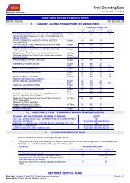
NORTH GEELONG TO YELTA NETWORK SERVICE PLAN - V/Line
NORTH GEELONG TO YELTA NETWORK SERVICE PLAN - V/Line
NORTH GEELONG TO YELTA NETWORK SERVICE PLAN - V/Line

You also want an ePaper? Increase the reach of your titles
YUMPU automatically turns print PDFs into web optimized ePapers that Google loves.
Regional Network and Access<br />
BROAD GAUGE<br />
<strong>NORTH</strong> <strong>GEELONG</strong> <strong>TO</strong> <strong>YELTA</strong><br />
1. CLASS OF LOCOMOTIVE AND PERMITTED SPEEDS (KM/H)<br />
<strong>NETWORK</strong> <strong>SERVICE</strong> <strong>PLAN</strong><br />
NA_NSP_02.09 – R02-2012<br />
CLASS OF LOCOMOTIVE<br />
G, XR, BL A, B, EL, T, P, H Y Sprinter/<br />
GM, N, S, X<br />
Vlocity<br />
<strong>NORTH</strong> <strong>GEELONG</strong> ‘A’ BOX (decommissioned) and Freight<br />
30 30<br />
30 30 ..<br />
<strong>NORTH</strong> <strong>GEELONG</strong> ‘C’ BOX<br />
Pass<br />
40 40<br />
40 .. 40<br />
<strong>NORTH</strong> <strong>GEELONG</strong> STATION and<br />
<strong>NORTH</strong> <strong>GEELONG</strong> ‘C’ BOX<br />
All Trains 30 30 30 30 30<br />
<strong>NORTH</strong> <strong>GEELONG</strong> ‘C’ BOX prior to the turnout at Freight<br />
15 15<br />
15 15<br />
(71.050km) and after the gauge splitter (72.300km) on<br />
the dual gauge track<br />
Pass<br />
15 15<br />
15 .. 15<br />
Gauge splitter (72.300km) and Butcher’s Road PCR Freight<br />
80 80<br />
80 65 ..<br />
(81.658km) Up side of GHERINGHAP<br />
Pass<br />
80 80<br />
80 .. 80<br />
Except all Broad Gauge trains between Evans Road<br />
PCR (76.631km) and Steiglitz Road PCR (77.404km)<br />
All Trains 65 65 65 65 65<br />
Butcher’s Road PCR (81.658km) Up side of<br />
Freight<br />
80 80<br />
80 65 ..<br />
GHERINGHAP and Humffray St PCR (113.120km via<br />
Ballan) at BALLARAT EAST<br />
Pass<br />
80 80<br />
80 .. 80<br />
Humffray St PCR (113.120km via Ballan) at BALLARAT<br />
EAST and BALLARAT <strong>NORTH</strong> JUNCTION (through<br />
BALLARAT)<br />
All Trains 40 40 40 40 40<br />
BALLARAT <strong>NORTH</strong> JUNCTION and MARYBOROUGH Freight 80 80 80 65 ..<br />
DOWN Direction BALLARAT <strong>NORTH</strong> JUNCTION to<br />
Millers Road PCR (161.050km).<br />
Pass 80 80 80 .. 80♦<br />
Millers Road PCR (161.050km) to Location Board<br />
(220.680km) at Maryborough.<br />
Pass 80 100 100 .. 100♦<br />
Location Board (220.680km) at Maryborough to Fixed<br />
Points at Up end of Maryborough at 223.654km Broad<br />
Gauge Only<br />
Pass 80 80 80 .. 80♦<br />
Over Fixed Points at Up end of Maryborough at<br />
223.654km Broad Gauge Only<br />
All Trains 65 65 65 65 65♦<br />
BALLARAT <strong>NORTH</strong> JUNCTION and MARYBOROUGH Freight 80 80 80 65 ..<br />
UP Direction Over Fixed Points at Up end of<br />
Maryborough at 223.654km Broad Gauge Only<br />
All Trains 65 65 65 65 65♦<br />
Fixed Points at Up end of Maryborough at 223.654km to<br />
Lean Street PCR (222.659km)<br />
Pass 80 80 80 .. 80♦<br />
Lean Street PCR (222.659km) and Rose Hill Road<br />
(161.834km) PCR)<br />
Pass 80 100 100 .. 100♦<br />
Rose Hill Road PCR (161.834km) to BALLARAT<br />
<strong>NORTH</strong> JUNCTION<br />
Pass 80 80 80 .. 80♦<br />
MARYBOROUGH and DUNOLLY Freight 80 80 80 65 ..<br />
Over Fixed Points at Up end of Dunolly at 245.324km<br />
Broad Gauge Only<br />
Freight 65 65 65 65 ..<br />
DUNOLLY and ST ARNAUD Sunraysia Highway PCR<br />
(298.558km)<br />
Freight 80 80 80 65<br />
ST ARNAUD Sunraysia Highway PCR (298.558km) and<br />
Wimmera Highway PCR (299.658km)<br />
Freight 50 50 50 50<br />
ST ARNAUD Wimmera Highway PCR (299.658km) and<br />
DONALD Campbell Street PCR (337.265km)<br />
Freight 80 80 80 65 ..<br />
DONALD Campbell Street PCR (337.265km) and<br />
BIRCHIP Berriwillock Road PCR (390.632km)<br />
Freight 70 70 70 65 ..<br />
BIRCHIP Berriwillock Road PCR (390.632km) and<br />
OUYEN (508.000km)<br />
Freight 80 80 80 65<br />
OUYEN (508.000km) and William Street PCR<br />
(509.492km)<br />
Freight 60 60 60 60<br />
OUYEN William Street PCR (509.492km) and<br />
RED CLIFFS Murray Street PCR (594.440km)<br />
Freight 80 80 80 65<br />
RED CLIFFS Murray Street PCR (594.440km and<br />
Fitzroy Avenue PCR (595.487km)<br />
Freight 70 70 70 65<br />
RED CLIFFS Fitzroy Avenue PCR (595.487km) and<br />
MILDURA (609.323km)<br />
Freight 80 80 80 65<br />
MILDURA (609.323km) and Eleventh Street PCR.<br />
(610.990km)<br />
Freight 25 25 25 25 ..<br />
MILDURA Eleventh Street PCR (610.990km) and<br />
MERBEIN Calder Highway PCR. (620.783km)<br />
Freight 65 65 65 65 ..<br />
Print Date: Monday, 1 October 2012 Printed copies are uncontrolled Page 1 of 8<br />
Approved by: General Manager, Network Services
Regional Network and Access<br />
BROAD GAUGE<br />
<strong>NORTH</strong> <strong>GEELONG</strong> <strong>TO</strong> <strong>YELTA</strong><br />
<strong>NETWORK</strong> <strong>SERVICE</strong> <strong>PLAN</strong><br />
NA_NSP_02.09 – R02-2012<br />
Over Calder Highway PCR. (620.783km ) at MERBEIN Freight 10 10 10 10 ..<br />
MERBEIN Calder Highway PCR. (620.783km ) and<br />
<strong>YELTA</strong><br />
Note ♦ Vlocity cars only (Sprinter cars NOT authorised).<br />
Freight 65 65 65 65 ..<br />
2. SPECIAL SPEED RESTRICTIONS<br />
1. All train movements to or from BALLARAT EAST Locomotive Depot must not exceed 10km/h.<br />
2. All Down trains entering the Freight Arrival Track from BALLARAT EAST end must not exceed 10km/h.<br />
3. The speed of all trains when passing over Facing Points worked from an interlocking frame or otherwise securely<br />
fastened, or over Trailing Points shall be as shown hereunder:<br />
LOCATION MAXIMUM SPEED KM/H<br />
When running to or from lines When running on<br />
diverging from the straight track the straight track<br />
Over facing points held by hand 15 15<br />
Between <strong>NORTH</strong> <strong>GEELONG</strong> and WARRENHEIP<br />
(except at <strong>NORTH</strong> <strong>GEELONG</strong> ‘C’ BOX, MEREDITH, and<br />
WARRENHEIP)<br />
40 <strong>Line</strong> speed for<br />
train type<br />
At MEREDITH 60 <strong>Line</strong> speed for<br />
train type<br />
At WARRENHEIP over Trailable Points<br />
Over Facing Trailable Points<br />
Over Trailing Trailable Points until locomotives clears Points<br />
Over Trailing Trailable Points after the locomotives clears Points<br />
Between <strong>NORTH</strong> BALLARAT JUNCTION and <strong>YELTA</strong><br />
(except over Trailable points and at MARYBOROUGH, DUNOLLY<br />
(No. 1 Road) and MERBEIN)<br />
Print Date: Monday, 1 October 2012 Printed copies are uncontrolled Page 2 of 8<br />
Approved by: General Manager, Network Services<br />
40<br />
-<br />
-<br />
40<br />
-<br />
40<br />
60<br />
<strong>Line</strong> speed for<br />
train type<br />
Over Trailable Points <strong>Line</strong> speed if<br />
lesser than<br />
indicated below<br />
Over Facing Trailable Points<br />
Over Trailing Trailable Points until locomotive clears points<br />
Over Trailing Trailable points AFTER the locomotive clears points<br />
At MARYBOROUGH (between Up end fixed points and km<br />
226.000)<br />
All Broad Gauge Trains<br />
All Standard Gauge Trains<br />
At DUNOLLY No. 1 Road over Dual Gauge Crossing work<br />
(All Down Broad Gauge Trains)<br />
40<br />
40<br />
40<br />
80<br />
65<br />
80<br />
35<br />
50<br />
40<br />
50<br />
- 50<br />
At MERBEIN 15 30<br />
4. Dunolly - A Notice Board is provided at the DOWN end of the<br />
platform advising that stopped DOWN Trains Maximum<br />
Speed to crossing is not to exceed 20 km/h.<br />
5. Dunolly - A Notice Board is provided at Signal Post No. 3<br />
advising that the Maximum Speed for stopped UP Trains to<br />
Thompson Road PCR (246.252km) is not to exceed 70 km/h.<br />
6. St Arnaud – A Notice Board is provided at the DOWN end of<br />
the platform advising that stopped DOWN Trains Maximum<br />
Speed to the crossing is not to exceed 25 km/h<br />
S<strong>TO</strong>PPED TRAINS<br />
MAXIMUM SPEED <strong>TO</strong><br />
CROSSING 20 KM/H<br />
S<strong>TO</strong>PPED TRAINS<br />
MAXIMUM SPEED <strong>TO</strong><br />
THOMPSON ROAD 70 KM/H<br />
S<strong>TO</strong>PPED TRAINS<br />
MAXIMUM SPEED <strong>TO</strong><br />
CROSSING 25 KM/H
Regional Network and Access<br />
BROAD GAUGE<br />
<strong>NORTH</strong> <strong>GEELONG</strong> <strong>TO</strong> <strong>YELTA</strong><br />
7. Birchip - A Notice Board is provided at the UP end of the<br />
Crossing Loop advising that the Maximum Speed for UP<br />
Stopped Trains to Wycheproof Road PCR (389.278km) is not<br />
to exceed 40 km/h .<br />
8. Woomelang – A Notice Board is provided at the UP end of<br />
the Crossing Loop advising that stopped UP Trains<br />
Maximum Speed to crossing is not to exceed 15 km/h<br />
9. Woomelang – A Notice Board is provided at the DOWN end<br />
of the Crossing loop advising that stopped DOWN Trains<br />
Maximum Speed to crossing is not to exceed 15 km/h<br />
10. Ouyen - A Notice Board is provided at approximately 400<br />
metres DOWN end of Mallee Highway PCR (508.527km)<br />
advising that the Maximum Speed for UP Trains to crossing<br />
not to exceed 40 km/h .<br />
3. RULING GRADE LOADS (<strong>TO</strong>NNES)<br />
SECTION CLASS OF LOCOMOTIVE<br />
G, XR,<br />
BL<br />
N EL,<br />
GM, S,<br />
X<br />
Mod A<br />
Class<br />
Non-<br />
Mod A<br />
solo or<br />
multi<br />
with<br />
other<br />
class<br />
Non-<br />
Mod A<br />
multi<br />
with<br />
other<br />
class<br />
B H solo<br />
or multi<br />
with H,<br />
P, T or<br />
Y<br />
<strong>NETWORK</strong> <strong>SERVICE</strong> <strong>PLAN</strong><br />
NA_NSP_02.09 – R02-2012<br />
Print Date: Monday, 1 October 2012 Printed copies are uncontrolled Page 3 of 8<br />
Approved by: General Manager, Network Services<br />
H multi<br />
with<br />
other<br />
class<br />
S<strong>TO</strong>PPED TRAINS<br />
MAXIMUM SPEED <strong>TO</strong><br />
WYCHEPROOF ROAD<br />
40 KM/H<br />
S<strong>TO</strong>PPED TRAINS<br />
MAXIMUM SPEED <strong>TO</strong><br />
CROSSING 15 KM/H<br />
S<strong>TO</strong>PPED TRAINS<br />
MAXIMUM SPEED <strong>TO</strong><br />
CROSSING 15 KM/H<br />
S<strong>TO</strong>PPED TRAINS<br />
MAXIMUM SPEED <strong>TO</strong><br />
MALLEE HIGHWAY 40 KM/H<br />
T or P<br />
solo or<br />
multi<br />
with H,<br />
P, T or Y<br />
T or P<br />
multi<br />
with<br />
other<br />
class<br />
Y solo<br />
or multi<br />
with T,<br />
Y, H or<br />
P<br />
DOWN<br />
Nth Geelong Yard to<br />
GHERINGHAP 2250 1625 1625 1960 1420 1420 1420 915 915 915 915 610 610<br />
MEREDITH .. 1120 1120 1500 985 985 985 660 660 660 660 445 445<br />
LAL LAL .. 1170 1170 1550 1015 1015 1015 710 710 710 710 465 465<br />
BALLARAT 2000 1625 1625 2300 1420 1420 1420 1015 1015 1015 1015 660 660<br />
Ballarat to<br />
MARYBOROUGH<br />
Maryborough to<br />
1520 1030 815 1030 830 750 670 560 560 560 480 280 250<br />
DUNOLLY 1710 1220 970 1220 1060 950 770 620 560 .. .. .. ..<br />
BEALIBA 1530 1120 .. 1120 .. .. 730 630 570 .. .. .. ..<br />
ST.ARNAUD 1610 1150 915 1150 940 850 .. 620 560 .. .. .. ..<br />
SUTHERLAND 2210 1060 965 1060 970 870 760 640 580 570 510 310 280<br />
DONALD<br />
Donald to<br />
4570 3430 2360 3430 2720 2450 1710 1260 1200 1200 1080 650 600<br />
WOOMELANG 4150 3300 3000 3300 2690 2420 2320 1770 1625 1625 1460 800 720<br />
TURRIFF 3370 2910 2360 2910 2180 1960 1530 1250 1130 1110 1000 560 500<br />
TEMPY 3940 2800 2030 2800 2220 2000 1660 1240 1120 1130 1020 610 550<br />
OUYEN 2650 2050 1870 2050 1950 1760 1600 1450 1310 1280 1200 780 700<br />
KIAMAL 4530 3610 2530 3610 3400 3060 1710 1240 1120 950 860 670 600<br />
CARWARP 3230 2850 2020 2850 2500 2250 1540 1430 1290 1290 1160 750 680<br />
MILDURA 3000 2200 2060 2200 2120 1910 1840 1720 1550 1590 1430 850 800<br />
Mildura to <strong>YELTA</strong><br />
UP<br />
2500 1860 1500 1860 1600 1600 1250 1020 1020 1020 1020 610 610<br />
Yelta to MILDURA<br />
Mildura to<br />
.. 2940 2460 2940 2520 2520 2000 1500 1500 1500 1500 850 850<br />
IRYMPLE 4940 4410 3540 4410 3730 3360 2970 2260 2030 2060 1850 1230 1110<br />
REDCLIFFS 3870 2820 2090 2820 2260 2030 1740 1280 1150 1130 1020 600 540<br />
KIAMAL 3830 2870 2690 2870 2780 2500 2430 1740 1570 1420 1280 700 600<br />
OUYEN 4940 4430 3970 4430 4180 3760 2150 2020 1625 1870 1625 1650 1065<br />
SPEED 2800 1920 1500 1920 1610 1450 1240 1000 910 910 820 500 450<br />
TURRIFF .. .. .. .. .. 1525 1080 970 830 750 600 540<br />
WOOMELANG 4050 3220 2850 3220 3040 2740 2190 1720 1550 1570 1410 1020 920<br />
Y multi<br />
with<br />
other<br />
class
Regional Network and Access<br />
BROAD GAUGE<br />
<strong>NORTH</strong> <strong>GEELONG</strong> <strong>TO</strong> <strong>YELTA</strong><br />
SECTION CLASS OF LOCOMOTIVE<br />
G, XR,<br />
BL<br />
N EL,<br />
GM, S,<br />
X<br />
Mod A<br />
Class<br />
Non-<br />
Mod A<br />
solo or<br />
multi<br />
with<br />
other<br />
class<br />
Non-<br />
Mod A<br />
multi<br />
with<br />
other<br />
class<br />
B H solo<br />
or multi<br />
with H,<br />
P, T or<br />
Y<br />
<strong>NETWORK</strong> <strong>SERVICE</strong> <strong>PLAN</strong><br />
NA_NSP_02.09 – R02-2012<br />
Print Date: Monday, 1 October 2012 Printed copies are uncontrolled Page 4 of 8<br />
Approved by: General Manager, Network Services<br />
H multi<br />
with<br />
other<br />
class<br />
T or P<br />
solo or<br />
multi<br />
with H,<br />
P, T or Y<br />
T or P<br />
multi<br />
with<br />
other<br />
class<br />
Y solo<br />
or multi<br />
with T,<br />
Y, H or<br />
P<br />
WATCHUPGA 4540 3840 2020 3840 1860 1670 1610 1400 1260 1300 1170 700 630<br />
WATCHEM 3000 2460 2250 2460 2340 2110 1950 1780 1600 1580 1420 1000 900<br />
DONALD<br />
Donald to<br />
3920 2950 2700 2950 2790 2510 2400 2230 2010 2030 1830 1660 1490<br />
COPE COPE .. 4840 4270 4840 4500 4050 3620 3200 2880 2740 2450 1640 1480<br />
SWANWATER .. 1210 960 1210 1060 950 815 660 590 600 560 360 330<br />
SUTHERLAND .. 2740 2310 2740 2560 2300 1920 1480 1330 1350 1220 790 710<br />
EMU 1520 1120 915 1130 950 860 815 630 570 570 510 310 280<br />
BEALIBA .. 3400 2800 3400 2970 2670 2190 1590 1430 1340 1210 810 810<br />
DUNOLLY 1760 1280 1020 1280 1080 970 840 680 .. 630 570 355 ..<br />
MARYBOROUGH<br />
Maryborough to<br />
1655 1200 950 1200 970 870 815 660 610 610 540 350 320<br />
BALLARAT<br />
Ballarat to<br />
1520 1120 915 1200 920 830 815 590 590 540 490 290 260<br />
WARRENHEIP 1520 865 915 1120 760 760 760 455 455 455 455 355 355<br />
GHERINGHAP 2500 .. .. .. .. .. .. .. .. .. .. ..<br />
NTH <strong>GEELONG</strong> YARD 3200 2135 2135 3200 2135 2135 2135 2030 2030 2030 2030 1420 1420<br />
4. SAFEWORKING SYSTEMS<br />
Siding Conditions is in force between the access to <strong>NORTH</strong> <strong>GEELONG</strong> YARD at <strong>NORTH</strong> <strong>GEELONG</strong> STATION and<br />
<strong>NORTH</strong> <strong>GEELONG</strong> ‘C’ Signalbox.<br />
Centralised Traffic Control system of signalling (Operated by ARTC) is in force between <strong>NORTH</strong> <strong>GEELONG</strong> ‘C’ BOX and<br />
GHERINGHAP – CTC continues on the Standard Gauge into GHERINGHAP Loop. On the Broad Gauge, Train Order<br />
Working commences at a point adjacent to Up signal Post 83/14 (BATESFORD) to GHERINGHAP Loop Broad Gauge<br />
and continues as listed below – GHERINGHAP Loop Broad Gauge is a D.I.C.E (Driver Initiated Control Equipment)<br />
Location.<br />
Train Order Working is in force between BATESFORD (adjacent to UP signal post 83/14) and BALLARAT EAST<br />
(adjacent to Signal Post No 50).<br />
Station Yard Working is in force between BALLARAT EAST and <strong>NORTH</strong> BALLARAT controlled from a Visual Display<br />
Unit located at BALLARAT.<br />
Train Order Working is in force between <strong>NORTH</strong> BALLARAT ( adjacent to Signal Post No 4) and <strong>YELTA</strong><br />
STATUS – ATTENDED STATUS – UNATTENDED<br />
BATESFORD Unattended location Unattended Train Order Terminal Station<br />
GHERINGHAP LOOP (Broad Gauge) Attended Crossing Station Unattended Crossing Station (DICE Loop)<br />
LETHBRIDGE BLOCK POINT Block Point Location Block Point Location<br />
MEREDITH Attended Crossing Station Intermediate Train Order Station<br />
LAL LAL BLOCK POINT Block Point Location Block Point Location<br />
WARRENHEIP LOOP Not Applicable Unattended Crossing Loop<br />
BALLARAT EAST Attended Terminal Station Attended for all Trains<br />
<strong>NORTH</strong> BALLARAT Attended Terminal Station Attended for all Trains<br />
MARYBOROUGH Intermediate Terminal Station Intermediate Terminal Station<br />
DUNOLLY Attended Crossing Station Unattended Crossing Loop<br />
EMU LOOP Unattended Crossing Loop Unattended Crossing Loop<br />
SUTHERLAND LOOP Unattended Crossing Loop Unattended Crossing Loop<br />
DONALD LOOP Unattended Crossing Loop Unattended Crossing Loop<br />
WATCHEM LOOP Unattended Crossing Loop Unattended Crossing Loop<br />
BIRCHIP LOOP Unattended Crossing Loop Unattended Crossing Loop<br />
CURYO BLOCK POINT Block Point Location Block Point Location<br />
WOOMELANG LOOP Unattended Crossing Loop Unattended Crossing Loop<br />
GAMA BLOCK POINT Block Point Location Block Point Location<br />
Y multi<br />
with<br />
other<br />
class
Regional Network and Access<br />
BROAD GAUGE<br />
<strong>NORTH</strong> <strong>GEELONG</strong> <strong>TO</strong> <strong>YELTA</strong><br />
STATUS – ATTENDED STATUS – UNATTENDED<br />
SPEED LOOP Unattended Crossing Loop Unattended Crossing Loop<br />
OUYEN Intermediate Terminal Station Intermediate Terminal Station<br />
HATTAH BLOCK POINT Block Point Location Block Point Location<br />
CARWARP LOOP Unattended Crossing Loop Unattended Crossing Loop<br />
YATPOOL BLOCK POINT Block Point Location Block Point Location<br />
LAKESIDE BLOCK POINT Block Point Location Block Point Location<br />
<strong>YELTA</strong> Unattended Location Unattended Train Order Terminal Station<br />
<strong>NETWORK</strong> <strong>SERVICE</strong> <strong>PLAN</strong><br />
NA_NSP_02.09 – R02-2012<br />
Master Keys are not required to be carried between BATESFORD and MARYBOROUGH unless required for Shunting at<br />
the intermediate sidings at GHERINGHAP and or LAL LAL.<br />
5. SPECIAL NOTES<br />
No Special Notes.<br />
6. DISTANCES FROM MELBOURNE AND CLEAR LENGTH OF CROSSING ROADS<br />
LOCATION MARKED DISTANCE FROM<br />
MELBOURNE (KM)<br />
(VIA <strong>NORTH</strong> <strong>GEELONG</strong> LOOP)<br />
CLEAR LENGTH OF CROSSING ROADS<br />
(LENGTH IN METRES)<br />
NO. 1 NO. 2<br />
<strong>NORTH</strong> <strong>GEELONG</strong> YARD 70.036 765 ..<br />
<strong>NORTH</strong> <strong>GEELONG</strong> ‘C’ BOX 71.142 .. ..<br />
GHERINGHAP 83.454 868 857<br />
LETHBRIDGE BLOCK POINT 97.100 .. ..<br />
LETHBRIDGE 99.262 .. ..<br />
MEREDITH 114.198 860 860<br />
LAL LAL 134.758 .. ..<br />
LAL LAL BLOCK POINT 137.440 .. ..<br />
WARRENHEIP LOOP 148.748 1120 1120<br />
BALLARAT EAST END 154.694 .. ..<br />
BALLARAT 155.386 .. ..<br />
<strong>NORTH</strong> BALLARAT JUNCTION 156.900 .. ..<br />
CRESWICK 174.563<br />
CLUNES 192.556<br />
MARYBOROUGH 224.041 889 787<br />
DUNOLLY 246.099 819 819<br />
BEALIBA 265.637 .. ..<br />
EMU LOOP 277.736 840 840<br />
ST ARNAUD 299.171 .. ..<br />
SUTHERLAND LOOP 310.428 1000 1000<br />
SWANWATER 317.889 .. ..<br />
COPE COPE 325.490 .. ..<br />
DONALD FREEZING WORKS SIDING 336.190 .. ..<br />
DONALD LOOP 336.749 734 734<br />
DONALD 337.597 ..<br />
LITCHFIELD 352.709 .. ..<br />
MASSEY 361.260 .. ..<br />
WATCHEM LOOP 369.768 970 970<br />
MOR<strong>TO</strong>N PLAINS 377.558 .. ..<br />
BIRCHIP A.W.B. OUT LOADING FACILITY 386.048<br />
BIRCHIP LOOP 389.460 825 825<br />
KINNABULLA 405.049 .. ..<br />
CURYO 410.390 .. ..<br />
CURYO BLOCK POINT 411.000 .. ..<br />
WATCHUPGA 421.799 .. ..<br />
WOOMELANG LOOP 432.095 640 640<br />
LASCELLES 443.656 .. ..<br />
GAMA BLOCK POINT 451.850 .. ..<br />
GAMA 452.281 .. ..<br />
Print Date: Monday, 1 October 2012 Printed copies are uncontrolled Page 5 of 8<br />
Approved by: General Manager, Network Services
Regional Network and Access<br />
BROAD GAUGE<br />
<strong>NORTH</strong> <strong>GEELONG</strong> <strong>TO</strong> <strong>YELTA</strong><br />
LOCATION MARKED DISTANCE FROM<br />
MELBOURNE (KM)<br />
(VIA <strong>NORTH</strong> <strong>GEELONG</strong> LOOP)<br />
<strong>NETWORK</strong> <strong>SERVICE</strong> <strong>PLAN</strong><br />
NA_NSP_02.09 – R02-2012<br />
CLEAR LENGTH OF CROSSING ROADS<br />
(LENGTH IN METRES)<br />
NO. 1 NO. 2<br />
TURRIFF 463.053 .. ..<br />
SPEED LOOP 469.844 800 800<br />
TEMPY 476.417 .. ..<br />
BRONZEWING 494.111 .. ..<br />
NUNGA 500.973 .. ..<br />
OUYEN 508.758 800 800<br />
KIAMAL 517.364 .. ..<br />
HATTAH 543.018<br />
HATTAH BLOCK POINT 543.018 .. ..<br />
CARWARP LOOP 578.108 .. ..<br />
YATPOOL BLOCK POINT 592.700 .. ..<br />
REDCLIFFS 594.955 .. ..<br />
IRYMPLE 602.635 .. ..<br />
MILDURA CEMENT SIDING 606.000 664<br />
SARNIA PACKING CO. SIDING 608.000 183 ..<br />
MILDURA CO. OP. FRUIT CO. SIDING 608.000 .. ..<br />
MILDURA 609.323 543<br />
MILDURA OIL SIDING 611.000 111 ..<br />
LAKESIDE BLOCK POINT 616.000<br />
MERBEIN UP END SIDING 620.250 445 445<br />
MERBEIN 620.510 .. ..<br />
MERBEIN WAKEFIELD’S SIDING 620.833 350 350<br />
MERBEIN SIDING 620.850 280 280<br />
<strong>YELTA</strong> 629.900 342 342<br />
Track is maintained to the following class standards.<br />
SECTION CLASS<br />
GHERINGHAP – MILDURA CLASS 3<br />
MILDURA – <strong>YELTA</strong> CLASS 4<br />
NAME AND KMS OF<br />
NEAREST STATION<br />
7. TRACK CLASS<br />
8. PROTECTED LEVEL CROSSINGS<br />
LEVEL CROSSING DISTANCE (KM)<br />
(VIA <strong>NORTH</strong><br />
<strong>GEELONG</strong> LOOP)<br />
TYPE LOCATION<br />
NUMBER<br />
VIC<br />
ROADS<br />
ID NO.<br />
GHERINGHAP – 83.454 Burnside Road 88.370 FL GV0883<br />
High Street 89.694 FL GE0896<br />
LETHBRIDGE – 99.262 Station Street 99.193 FL GE0991<br />
MEREDITH – 114.198 Staughton Street 114.127 FL GE1141<br />
♣ *Midland Highway 123.064 BB AL1230 19007<br />
LAL LAL – 134.758 Clarendon Street 134.549 FL AL1348<br />
Main Street 140.360 FL AL1403<br />
BALLARAT – 155.386 Humffray Street 154.694 BB, PG A1181<br />
Lydiard Street 155.508 IG, PG A1189<br />
Doveton Street 156.336 BB A1193<br />
McArthur Street 156.867 BB AM1199<br />
Howitt Street 157.786 BB AM1207<br />
Norman Street 158.597 BB AM1215<br />
Heinz Lane 159.441 FL AM1224<br />
* Millers Road 161.050 BB AM1240<br />
* Rosehill Road 161.834 BB AM1248<br />
* Frasers Road 162.675 BB AM1256<br />
* Pistol Club Road 163.862 BB AM1268<br />
Print Date: Monday, 1 October 2012 Printed copies are uncontrolled Page 6 of 8<br />
Approved by: General Manager, Network Services
Regional Network and Access<br />
BROAD GAUGE<br />
NAME AND KMS OF<br />
NEAREST STATION<br />
<strong>NORTH</strong> <strong>GEELONG</strong> <strong>TO</strong> <strong>YELTA</strong><br />
LEVEL CROSSING DISTANCE (KM)<br />
(VIA <strong>NORTH</strong><br />
<strong>GEELONG</strong> LOOP)<br />
<strong>NETWORK</strong> <strong>SERVICE</strong> <strong>PLAN</strong><br />
TYPE LOCATION<br />
NUMBER<br />
CRESWICK – 174.563 * Taronga Road 164.497 BB AM1274<br />
NA_NSP_02.09 – R02-2012<br />
VIC<br />
ROADS<br />
ID NO.<br />
♣ * Midland Highway 166.081 BB AM1290 19008<br />
* Blackmore Road 166.876 BB AM1298<br />
* Grays Road 169.956 BB AM1329<br />
* Armstrong Street 173.781 BB AM1367<br />
Victoria Street 174.684 FL AM1376<br />
* Williams Road 176.032 BB AM1390<br />
* Johns Road 176.681 BB AM1396<br />
* Australasia Road 177.594 BB AM1405<br />
* Gillies Road 180.669 BB AM1436<br />
* Cattle Station Road 181.934 BB AM1449<br />
CLUNES – 192.556 * Anderson Road 184.020 BB AM1470<br />
* Tourello Road 185.110 BB AM1481<br />
* Ballarat Road 186.962 BB AM1499<br />
* Cooks Road 188.556 BB AM1515<br />
* Black Swamp Road 190.130 BB AM1531<br />
* Boundary Street 192.286 BB AM1552<br />
* Learmonth Road 193.362 FL AM1563<br />
Kilkenny Lane 193.600 FG AM1566<br />
* Roses Lane 194.010 BB AM1570<br />
* Cemetery Road 194.904 BB AM1579<br />
* Beckworth Court Road 197.329 BB AM1603<br />
Adams Track 199.746 FG AM1627<br />
Hull Lane 205.209 FG AM1682<br />
* Old Ballarat Road 206.825 FL AM1698<br />
MARYBOROUGH – 224.041 * Ballarat/Maryborough Road 209.269 BB AM1722<br />
* Scandinavian Cres 209.531 FL AM1725<br />
* Champions Road 212.023 BB AM1750<br />
* Carisbrook – Talbot Road 215.222 BB AM1782<br />
Walters Road 216.335 FG AM1793<br />
* Denherts Road 217.862 FL AM1808<br />
Lean Street 222.689 FL AM1856<br />
Inkerman Street 223.742 BB AM1867<br />
Tulleroop Road 226.106 FL AM1891<br />
* Dooleys Road 227.218 FL AM1902<br />
Eddington Road 234.591 FL N1975<br />
Dunolly Road 238.916 FL N2019<br />
DUNOLLY – 246.111 Thompson Road 246.252 FL N2092<br />
BEALIBA – 265.637 Avoca Road 266.544 FL N2295<br />
EMU – 277.736 St. Arnaud Road 279.414 FL N2424<br />
ST ARNAUD – 299.171 Sunraysia Highway 298.558 FL N2615<br />
Howitt Street 298.949 FL N2619<br />
Millet Street 299.420 FL N2624<br />
Wimmera Highway 299.656 FL N2626<br />
Alma Street 300.023 FL N2630<br />
Wellington Road 300.403 FL N2634<br />
Sunraysia Highway 300.667 FL N2636<br />
♣ Sunraysia Highway 322.933 FL N2859 7273<br />
DONALD – 337.597 ♣ Sunraysia Highway 336.190 FL N2991 19019<br />
Campbell Street 337.265 FL N3002<br />
Hammill Street 337.931 FL N3009<br />
♣ Sunraysia Highway 344.867 FL N3078 7275<br />
LITCHFIELD – 352.709 ♣ * Borung Highway 353.111 BB N3161 7276<br />
MASSEY – 361.260 ♣ Sunraysia Highway 361.475 BB N3244 7277<br />
WATCHEM – 369.768 Corack Road 370.015 BB N3331<br />
Print Date: Monday, 1 October 2012 Printed copies are uncontrolled Page 7 of 8<br />
Approved by: General Manager, Network Services
Regional Network and Access<br />
BROAD GAUGE<br />
NAME AND KMS OF<br />
NEAREST STATION<br />
<strong>NORTH</strong> <strong>GEELONG</strong> <strong>TO</strong> <strong>YELTA</strong><br />
LEVEL CROSSING DISTANCE (KM)<br />
(VIA <strong>NORTH</strong><br />
<strong>GEELONG</strong> LOOP)<br />
<strong>NETWORK</strong> <strong>SERVICE</strong> <strong>PLAN</strong><br />
TYPE LOCATION<br />
NUMBER<br />
BIRCHIP – 389.460 * Aerodrome Road 387.175 FL N3501<br />
NA_NSP_02.09 – R02-2012<br />
VIC<br />
ROADS<br />
ID NO.<br />
Corack Road 388.964 FL N3519<br />
Wycheproof Road 389.278 FL N3522<br />
Berriwillock Road 390.632 FL N3536<br />
Sea Lake Road 391.230 FL N3542<br />
WOOMELANG – 432.095 Sunraysia Highway 431.549 FL N3945<br />
Brook Street (Sunraysia Highway) 432.391 FL N3953<br />
LASCELLES – 443.560 ♣ Sunraysia Highway 443.262 FL N4062 7278<br />
OUYEN – 508.758 Ouyen Highway 508.527 FL N4715<br />
Williams Road 509.492 FL N4724<br />
REDCLIFFS – 594.955 Murray Avenue 594.440 FL N5574<br />
Fitzroy Avenue 595.486 FL N5584<br />
IRYMPLE – 602.635 Belar Avenue 600.369 FL N5633<br />
Irymple Avenue 602.427 FL N5654<br />
Calder Highway 603.191 BB N5661<br />
Karaduc Avenue 604.156 FL N5671<br />
Sandalong Avenue 605.103 FL N5681<br />
Cowra Avenue 606.045 FL N5690<br />
MILDURA – 609.323 Benetook Avenue & Eleventh St 606.973 FL N5699<br />
Ettiwande Avenue 607.705 FL N5707<br />
San Mateo Avenue 608.432 FL N5714<br />
Seventh Street (Sturt Highway) 608.828 FL N5718<br />
Chaffey Avenue 609.947 FL N5929<br />
Eleventh Street 610.990 FL N5739<br />
Thirteenth Street 611.486 FL N5744<br />
Ontario Avenue 612.486 FL N5754<br />
MERBEIN – 620.510 River Avenue 619.108 FL N5821<br />
♣ Calder Highway 620.783 FL N6207 19019<br />
Paschendale Avenue 624.603 FL N5876<br />
BB – Boom Barriers CC – Crib Crossing FL – Flashing Lights IG – Interlocked Gates<br />
NSW – R.I.C. Distance from Sydney PB – Pedestrian Barriers PG – Pedestrian Gates SG – Standard Gauge<br />
T – Equipped with Telephone Communication VIC – Victorian Broad Gauge FG – Frangible Gates<br />
Note * Indicates those level crossings where an increase in speed may be permitted if the train is travelling at or above<br />
50km/h upon passing the predictor indicator board.<br />
At these level crossings indicated above operated with Level Crossing Predictors, the Predictor boards will be<br />
placed in accordance with Rule 9 (Section 36) of the Book of Rules and Operating Procedures.<br />
Note ♣ Level crossing fitted with VicRoads Active Advance Warning Signs. Warning sign faults are to be reported to the<br />
VicRoads Fault Centre on 131170.<br />
Print Date: Monday, 1 October 2012 Printed copies are uncontrolled Page 8 of 8<br />
Approved by: General Manager, Network Services