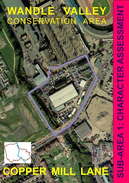
WANDLE VALLEY COPPER MILL LANE - Merton Council
WANDLE VALLEY COPPER MILL LANE - Merton Council
WANDLE VALLEY COPPER MILL LANE - Merton Council

You also want an ePaper? Increase the reach of your titles
YUMPU automatically turns print PDFs into web optimized ePapers that Google loves.
<strong>WANDLE</strong> <strong>VALLEY</strong><br />
CONSERVATION AREA<br />
<strong>COPPER</strong> <strong>MILL</strong> <strong>LANE</strong><br />
SUB-AREA 1: CHARACTER ASSESSMENT
1<br />
Amended Draft, revised<br />
following public consultation.<br />
New text shown underlined<br />
and deleted text shown<br />
struck through.
INTRODUCTION<br />
BACKGROUND<br />
STRUCTURE OF THE DOCUMENT<br />
CONTENTS<br />
LOCATION AND EXTENT OF THE CONSERVATION AREA<br />
SEQUENCE OF MAPS AND AERIAL PHOTOGRAPHS<br />
ORIGINS AND DEVELOPMENT OF THE AREA<br />
AGE OF BUILDINGS MAP<br />
LAND USE<br />
BUILDINGS<br />
PLOT WIDTHS AND BUILDING HEIGHTS<br />
OPEN SPACES<br />
Quality of Open Spaces and Means of Enclosure<br />
NEGATIVE FEATURES<br />
STREET AUDIT<br />
CONSERVATION AREA PROPOSALS AND POLICY<br />
SPECIAL GUIDANCE<br />
NEED FOR ADDITIONAL PLANNING CONTROLS<br />
REVIEW OF THE CONSERVATION AREA BOUNDARY<br />
3<br />
3<br />
3<br />
4<br />
5<br />
7<br />
8<br />
9<br />
9<br />
10<br />
11<br />
11<br />
12<br />
12<br />
13<br />
17<br />
18<br />
18<br />
2
INTRODUCTION<br />
<strong>WANDLE</strong> <strong>VALLEY</strong> CONSERVATION AREA<br />
CHARACTER ASSESSMENT<br />
SUB-AREA 1: <strong>COPPER</strong> <strong>MILL</strong> <strong>LANE</strong><br />
The designation of conservation areas is a<br />
legislative duty of local authorities. These<br />
areas comprise "areas of special<br />
architectural or historic interest, the<br />
character or appearance of which it is<br />
desirable to preserve or enhance". Local<br />
authorities also have a duty to from time to<br />
time to review whether any further<br />
designations are needed. The Wandle<br />
Valley Conservation Area was originally<br />
designated by the Counci in November<br />
1990 and was extended in April 2000.<br />
Character assessments are useful tools<br />
that not only set out the specific<br />
characteristics for which an area has been<br />
designated as a conservation area, but<br />
also help the <strong>Council</strong> to assess the impact<br />
of development proposals on the<br />
character or appearance of a<br />
conservation area. They also provide a<br />
useful framework within which property<br />
owners and developers can work when<br />
designing new development or planning<br />
alterations to buildings, within<br />
conservation areas, by setting out and<br />
describing the special context to which<br />
any new development will need to relate.<br />
This Character Assessment for the<br />
Wandle Valley Conservation Area has<br />
been prepared by the <strong>Council</strong>'s Design<br />
and Conservation Team in accordance<br />
with Guidelines issued by English<br />
Heritage and Planning Policy Guidance<br />
Note 15.<br />
STRUCTURE OF THE<br />
DOCUMENT<br />
Because of its size and linear nature the<br />
Wandle Valley conservation area, whilst<br />
BACKGROUND<br />
having a unifying theme linked to its<br />
history, development and links to the River<br />
The Government's Planning Policy Wandle, does vary in character along its<br />
Guidance Note 15: Planning and the length. The area has, therefore been sub-<br />
Historic Environment (PPG 15) advises divided into a series of smaller discernible<br />
local authorities to periodically review sub areas which have their own special<br />
existing conservation areas and their identities and which form recognisable<br />
boundaries. PPG 15 also advises local zones or groups of buildings within the<br />
authorities to define and record, as area as a whole and that have their own<br />
clearly as possible, the special specific historical background and/or<br />
architectural or historic interest that defining features.<br />
justifies each conservation area's<br />
designation, through an assessment of The character assessment for the Wandle<br />
the elements that contribute to an area's Valley Conservation Area has therefore<br />
character.<br />
been structured to comprise a general<br />
appraisal document covering the whole of<br />
the conservation area supported by a<br />
series of more detailed appraisals of each<br />
of the individual sub-areas.<br />
3<br />
This appraisal covers Sub Area 1: Copper<br />
Mill Lane and should be read in<br />
conjunction with the whole area character<br />
appraisal.<br />
The appraisal is not intended to<br />
be comprehensive and the omission of<br />
any particular building, feature or space<br />
should not be taken to imply that it is of no<br />
interest.
LOCATION AND EXTENT OF THE SUB- AREA<br />
The Copper Mill Lane sub-area covers<br />
a small separate area to the north of<br />
Plough Lane, isolated from main<br />
Conservation Area.<br />
This area embraces a small terrace of<br />
former mill workers cottages, built at the<br />
turn of the Century, the surviving factory<br />
building at the end of Copper Mill Lane<br />
and the site of the present car dealership<br />
fronting Plough Lane.<br />
Cable Bridge<br />
ETL<br />
Sub<br />
Station<br />
Sluice<br />
11.7m<br />
FB<br />
PLOUGH <strong>LANE</strong><br />
48<br />
50<br />
River River Wandle Wandle<br />
El Sub Sta<br />
ETL ETL<br />
66<br />
64<br />
Garage<br />
Garage<br />
BM BM 12.01m 12.01m<br />
67 67<br />
Mead Mead Path Path<br />
The area is included as a distinct and<br />
separate part of the Wandle Valley<br />
conservation area, connected through<br />
the River Wandle theme, because it’s<br />
character derives from its association with<br />
the River Wandle and riverside industry.<br />
This area is separated from the main part<br />
of the Conservation Area by the former<br />
site of the Wandle Valley Sewage Works,<br />
these were laid out in 1877 on the site of<br />
39 39<br />
9.9m<br />
53 53<br />
<strong>COPPER</strong> <strong>COPPER</strong> <strong>MILL</strong> <strong>MILL</strong> <strong>LANE</strong> <strong>LANE</strong><br />
31 31<br />
Garage<br />
9.4m<br />
Posts<br />
PLOUGH <strong>LANE</strong><br />
59<br />
53<br />
WATERSIDE WAY<br />
El Sub Sta<br />
9.4m<br />
Superstore<br />
4
SEQUENCE OF MAPS AND AERIAL PHOTOGRAPHS<br />
1817<br />
1865<br />
1890<br />
5<br />
1920<br />
1930<br />
1950
1971 1991<br />
1976<br />
1989<br />
1998<br />
6
old water meadows on the banks of the<br />
Wandle. The sewage works closed in<br />
1971 and the southern part of the derelict<br />
site has been transformed into the new<br />
Wandle Meadow Nature Park. Previously<br />
this area had been part of a royal game<br />
preserve that stretched from Wandsworth<br />
to <strong>Merton</strong> Abbey in the early 17th<br />
Century.The area embraces the site of an<br />
eighteenth century copper mill, however,<br />
the site is likely to have been occupied by<br />
ORIGINS AND DEVELOPMENT<br />
OF THEAREA<br />
This part of the conservation area has a<br />
long association with milling; records<br />
suggest that there has been a Mill on this<br />
site since 1114. There are references to a<br />
fulling mill on the Wandle in the Manor of<br />
Wimbledon leased to a John de Cromwell<br />
during the 15th Century and he was<br />
succeed by his son Walter. John Rocque’s<br />
watermills before this.<br />
map of 1741 shows Garrett’s Mill the<br />
copper mill from which Copper Mill Lane<br />
An outline of the history of the area and its obtains its name. The mill was working as<br />
development is provided within the main copper mill from about 1790 to 1887. The<br />
character appraisal as a background to it’s mill melted, cast and rolled copper. From<br />
historic significance. The main appraisal this copper many kinds of utensils were<br />
also provides a description and made including large vessels, some<br />
explanation of the area’s geology, weighing as much as four tons, made for<br />
topography, archaeology and ecology and brewing beer. In the 19th century the mill<br />
a more detailed summary of the origins and surrounding land was owned by<br />
and development of the conservation area Edward Pontifex, whose firm Pontifex<br />
and adjacent areas is set out. Brothers continued production until<br />
7
Sub Area 1: Copper Mill Lane - Age of Buildings Map<br />
Stand<br />
Depot<br />
Key:<br />
El Sub Station<br />
El<br />
Sub<br />
Sta<br />
Garage<br />
67 67<br />
39 39<br />
53<br />
<strong>COPPER</strong> <strong>MILL</strong> <strong>LANE</strong><br />
31 31<br />
Wimbledon<br />
Stadium<br />
Garage ge<br />
80<br />
PLOUGH <strong>LANE</strong><br />
59<br />
53<br />
WATERSIDE WAY<br />
Conservation Area Boundary Statutory List Local List<br />
1750-1799<br />
1800-1849<br />
Superstore<br />
Superstore<br />
1850-1899 1900-1949 1950-2000<br />
94<br />
The Plough<br />
Mead Path<br />
(PH)<br />
8
almost the end of the century, drawing an Century by Mr Chuter, the owner of the<br />
end to copper working on the Wandle. Leather works. An earlier terrace of<br />
millworkers cottages were located directly<br />
to the north of the surviving leather factory<br />
building, these became derelict and were<br />
eventually demolished in the 1960s.<br />
The 20ft diameter mill wheel was allegedly<br />
the largest on the river Wandle with 42<br />
paddles, 15ft long by 22 inches deep. The<br />
wheel was an undershot wheel powered<br />
by water passing underneath, similar to<br />
the surviving mill wheels at Ravensbury<br />
Mill. The wheel powered a single beam<br />
hammer which pounded the sheet copper<br />
into the required form. The sound of the<br />
hammer could be heard for a considerable<br />
distance and would have worked day and<br />
night.<br />
Chuter's Chamois Leather Works<br />
succeeded Pontifex Brothers at Garrett<br />
Mills and the wheel is reputed to have<br />
been the last wheel in use on the Wandle.<br />
During the war the mill employed<br />
around 50 people. The Mill appears to<br />
have been demolished during the late Adjacent to the conservation, immediately<br />
1970s/early 1980s and the Mill House, to the south of Plough Lane and to the<br />
which was located to the north of the west of the river Wandle, watercress beds<br />
main mill building, shortly afterwards. were laid out during the latter part of the<br />
The original river channel, along with 19th century and the first half of 20th<br />
part of mill race and mill stream appears century.<br />
to have been infilled at around this time.<br />
The surviving factory building, at the<br />
end of Copper Mill lane, to the southeast<br />
of the former mill dates from the<br />
end of the 19th Century and was a<br />
leather dressing factory within the mill<br />
complex attached to a much larger factory<br />
building to the rear on the site of the<br />
present car dealership fronting Plough<br />
Lane. The upper floor originally had timber<br />
louvres and was probably used for leather<br />
drying. To the east of the factory building is<br />
a small terrace of former mill workers<br />
cottages built at the turn of the 20th<br />
9<br />
LAND USE<br />
The development of the area reflects a<br />
pattern that can be found along the length<br />
of the Wandle comprising a mill complex<br />
with millworker cottages lining the main<br />
access road. This arrangement survives<br />
to the present day. As a result this part of<br />
the conservation area has historically<br />
been an area of mixed use comprising<br />
employment/industrial uses and<br />
associated residential development. The<br />
pattern of uses survives to the present day<br />
although the nature of the employment
uses has changed from primarily<br />
manufacturing/industrial to office and<br />
retail uses. The departure of mill based<br />
industries has resulted in the historic<br />
relationship between the industrial uses<br />
and the river being lost and as a<br />
consequence the Wandle has effectively<br />
been cut off from the main part of the<br />
conservation area. This is largely due to<br />
the nature of land ownership and the<br />
distribution of newer buildings adjacent to<br />
the river at the west end of Copper Mill<br />
Lane and along Plough Lane.<br />
BUILDINGS<br />
The main buildings of significance to the<br />
conservation area comprise the remnants<br />
of the riginal layout of the area, the factory<br />
building at the end of Copper Mill Lane<br />
and the surviving row of former millworker<br />
cottages on the south side of the lane.<br />
The industrial building is an early to mid<br />
19th Century brick built building a survival<br />
from the now demolished mill complex<br />
and which formed part of the former<br />
leather works. Constructed of yellow stock<br />
brick with a shallow pitched Welsh slate<br />
roof, the ground and first floors retain<br />
much of the original detailing, such as<br />
arched brick window openings with steel<br />
framed windows. The second floor has,<br />
however, been largely rebuilt. This was<br />
originally the drying room for the chamois<br />
leather factory which had large openings<br />
fitted with timber louvres to allow the free<br />
passage of air to assist the drying<br />
process.<br />
The cottages date form the end of the 19th<br />
Century and were the most recent of a<br />
larger group which included a mid-19th<br />
century terrace of seven cottages located<br />
immediately to the north of the factory<br />
building, a pair of semi-detached cottages<br />
to the west of the surviving cottages a<br />
small terrace of 3 cottages on the north<br />
side of Copper Mill Lane also dating from<br />
the mid 19th century. Set within narrow<br />
plots these are brick built terraces with<br />
cant bay windows originally with timber<br />
vertical hung sliding sash windows.<br />
Features include the use of polychromatic<br />
brickwork, exposed stone lintels and semicircular<br />
gauged brick arches over the front<br />
doors. The roof were originally tiled with<br />
Welsh slates, and has projecting party wall<br />
parapets. However many windows have<br />
been replaced with inappropriate modern<br />
equivalents and some of the roof have<br />
been retiled in concrete tiles. The houses<br />
are set back from the street with small front<br />
garden areas. There are narrow gardens<br />
to the rear that back onto a site currently<br />
occupied by a petrol filling station.<br />
Other buildings within this part of the<br />
conservation area comprise modern<br />
industrial shed buildings and car<br />
showroom associated with the car<br />
dealership fronting Plough Lane. These<br />
buildings do not reflect the historic pattern<br />
of development of this part of the<br />
conservation area and their design, whilst<br />
clearly industrial have little architectural<br />
merit and do not contribute to the<br />
character or appearance of the<br />
conservation area. Immediately to the<br />
10
north of the conservation area is the parallel to the street. The buildings in area<br />
infrastructure and associated buildings of B are set back much more significantly<br />
the Wimbledon Electricity Sub Station the along the Plough Lane frontage and are<br />
visual appearance of which is detrimental<br />
to the character of the area.<br />
also set back from the river frontage<br />
Generally the buildings in Area A are set<br />
back from the Copper Mill Lane frontage<br />
behind small front garden areas. The<br />
existing buildings are two-storey with<br />
pitched roofs with their ridges running<br />
OPEN SPACES<br />
PLOT WIDTHS AND BUILDING<br />
HEIGHTS<br />
Quality of open spaces and form<br />
of enclosure<br />
This part of the conservation area divides<br />
into two distinct areas.<br />
The open spaces within this part of the<br />
conservation area comprise undeveloped<br />
Area A: comprising strip running along the land dominated by car parking and high<br />
south side of Copper Mill Lane and which security fencing.<br />
comprise narrow plots currently and<br />
formerly occupied by terraces of cottages. The most significant open space, the River<br />
Wandle has no public access to its east<br />
Area B: comprising the area to the west bank. The spaces are unplanned and<br />
and south of Area A, at the end of Copper mainly comprise left over space between<br />
Mill Lane and fronting onto Plough Lane and around buildings and in their present<br />
with is characterised by a much more ad form contribute little to the character of the<br />
hoc arrangement of predominantly conservation area apart from their<br />
commercial buildings with larger footprints contribution to the overall spatial quality of<br />
and a variety of scales and heights which the area in terms of the layout, disposition<br />
has derived from the original mill and orientation of buildings. The main area<br />
complexes and adjacent workshops and of public realm comprising Copper Mill<br />
which has continued through to the Lane itself and the Plough Lane frontages<br />
present date.<br />
11<br />
are poorly managed, maintained and<br />
controlled. Uncertainty over ownership<br />
and control of Copper Mill Lane has<br />
resulted in problems with abandoned<br />
vehicles and inconsiderate parking<br />
practices.<br />
There are no significant individual trees<br />
within the conservation area, however<br />
there is a line of trees along the east bank<br />
of the Wandle which create a linear group<br />
of significance. Tree planting along the
Plough Lane frontage also provides a the design of future development,<br />
degree of softening to an otherwise particularly to the western part of the sub<br />
unwelcoming frontage. area as part of the conservation area<br />
management plan.<br />
NEGATIVE FEATURES<br />
In addition to the security fencing, spaces<br />
around the buildings and modern retail<br />
shed development to the west of the subarea<br />
on street parking and parking on the<br />
pavements in Copper Mill Lane also has a<br />
negative effect on the character of the<br />
conservation area. The problems stem<br />
from lack of clear control of Copper Mill<br />
There is scope for improvement through a Lane and efforts are required to reduce<br />
more co-ordinated and better managed this to a minimum through firmer controls<br />
approach to the public realm. A better and better street design<br />
disposition and quality of open spaces The large scale retail units fronting Plough<br />
along with the creation of links to the Lane are imposing and are out of<br />
Wandle should be secured through character with the conservation area;<br />
negotiation in connection with any future efforts should be made to mitigate their<br />
planning applications. It is recommended effect.<br />
that a Framework be prepared to inform<br />
12
STREET AUDIT<br />
There is little street furniture of special<br />
historic value within the conservation area<br />
itself, however immediately to the east at<br />
the turn in to the east end of Copper Mill<br />
Lane are some good examples of large<br />
format granite kerbs, some of which are<br />
curved around the small traffic island<br />
close to the junction of Plough Lane.<br />
CONSERVATION AREA PROPOSALS AND POLICY<br />
13<br />
There are also surviving areas of larger<br />
format paving slabs laid with tight joints.<br />
These details provide the basis of a<br />
palette for future highway works within the<br />
conservation area. The lack of any<br />
existing co-ordinated street furniture<br />
provides an opportunity for the<br />
introduction of new street furniture of a<br />
design developed to reflect the area’s<br />
industrial character and history.<br />
The policies and proposals set out in this policies and proposals seek to preserve<br />
document are intended to preserve or the best historic, landscape/townscape<br />
enhance the character and appearance of and architectural features that contribute<br />
the conservation area and assist in to essential character and historic interest<br />
managing change without compromising without stifling change. It will also form the<br />
the historic environment. The preservation basis for resolving problems such as the<br />
and enhancement of the historic integrity existing street environment, condition and<br />
of the conservation area as a whole is a appearance of open spaces and<br />
core objective of the document. These inappropriate boundary treatments.
In order to secure good quality The relevant policies within the adopted<br />
development that enhances the character Unitary Development Plan are:<br />
of the conservation area and address<br />
problems, appropriate methods and<br />
standards for new development and for<br />
alterations are proposed. A key<br />
recommendation of the document is that a<br />
strategy be adopted to provide a<br />
framework for future development of the<br />
west part of the conservation area that<br />
fronts the River Wandle and Plough Lane.<br />
1.<br />
2.<br />
In relation to Conservation Areas -<br />
polices BE.1 Conservation Areas,<br />
New Development, Change of Use,<br />
Alterations and Extensions, BE.2:<br />
Conservation Areas Demolition and<br />
BE.3 Development Adjacent to a<br />
Conservation Area.<br />
In relation to Archaeology - Policies<br />
BE.13: Archaeological Protection and<br />
The policies and proposals contained in Preservation, and BE.14<br />
this document accord with;<br />
Archaeological Evaluation.<br />
Government Planning Policy Notes;<br />
and<br />
3. In relation to New Buildings and<br />
Extensions - Policies BE.15: New<br />
<br />
<strong>Merton</strong>'s Unitary Development Plan.<br />
Buildings and Extensions; Daylight,<br />
The statutory development plan applying<br />
Sunlight, Privacy, Visual Intrusion and<br />
Noise, BE.16: Urban Design, BE.22:<br />
to Copper Mill Lane Sub-Area is the Design of New Development, Policy<br />
London Borough of <strong>Merton</strong> Unitary BE.23: Alterations and Extensions to<br />
Development Plan, adopted in October Buildings<br />
2003. This plan will eventually be replaced<br />
by the emerging Local Development<br />
Framework and supporting Action Plans<br />
and associated planning documents.<br />
4. In relation to Streetscape - Policy<br />
BE.33: Street Furniture and Materials.<br />
In terms of the application of those<br />
policies to this part of the Conservation<br />
14
Area the following supplemental polices<br />
are proposed to secure good<br />
management and to help achieve the<br />
objectives of preservation and<br />
enhancement of the character and<br />
WITHIN THIS PART OF THE CONSERVATION<br />
AREA, PROPOSALS FOR NEW<br />
DEVELOPMENT, ALTERATIONS OR<br />
EXTENSIONS OR FOR THE CHANGE OF USE<br />
OF LAND OR BUILDINGS WILL BE<br />
REQUIRED TO PRESERVE OR ENHANCE<br />
THE CHARACTER OR APPEARANCE OF THE<br />
SUB- AREA.<br />
PROPOSALS WILL BE EXPECTED TO:<br />
(i) RESPECT OR COMPLEMENT THE<br />
DESIGN, SCALE, FORM, LAYOUT AND<br />
MATERIALS OF SURVIVING HISTORIC<br />
BUILDINGS AS IDENTIFIED IN THE<br />
APPRAISAL<br />
(ii) RESPECT THE HISTORIC STREET<br />
PATTERN OR OTHER FEATURES<br />
CONTRIBUTING TO THE CHARACTER,<br />
HISTORIC VALUE OR THE PATTERN OF<br />
DEVELOPMENT IN THE AREA<br />
(iii) HAVE REGARD TO VIEWS WITHIN AND<br />
OUT OF THE AREA, PARTICULARLY<br />
TOWARDS THE RIVER <strong>WANDLE</strong><br />
(iv) ENSURE THAT THE LEVEL OF ACTIVITY,<br />
TRAFFIC, PARKING SERVICES OR<br />
NOISE GENERATED BY THE<br />
DEVELOPMENT WOULD NOT DETRACT<br />
FROM THE CHARACTER OR<br />
APPEARANCE OF THE AREA; AND<br />
(v) INCORPORATE USES OTHER THAN<br />
RETAIL TO CONTRIBUTE TO<br />
ACHIEVING COUNCIL OBJECTIVES<br />
TOWARDS DEVELOPING MORE<br />
SUSTAINABLE COMMUNITIES<br />
15<br />
PROPOSALS INVOLVING SITES WITH A<br />
RIVER FRONTAGE WILL ALSO BE<br />
EXPECTED TO PROVIDE ACCESS AND<br />
VIEWS THROUGH TO AND ALONG THE<br />
RIVER.<br />
appearance of the conservation area. With respect to development proposals<br />
These policies are informed by the<br />
involving demolition of buildings the<br />
Character Appraisal and aim to take it<br />
following supplementary policy will be<br />
forward as a positive plan for this part of<br />
taken into consideration.<br />
the conservation area.<br />
POLICY WV.CM2: DEMOLITIONS.<br />
With respect to development proposals TOTAL OR SUBSTANTIAL DEMOLITION OF<br />
the following supplementary policy is THE UNLISTED BUILDINGS THAT HAVE<br />
BEEN IDENTIFIED AS MAKING A POSITIVE<br />
proposed.<br />
CONTRIBUTION TO THE CHARACTER OR<br />
APPEARANCE OF THE CONSERVATION<br />
POLICY WV.CM1: NEW AREA WILL NOT BE PERMITTED.<br />
DEVELOPMENT, CHANGE OF USE, DEVELOPMENT PROPOSALS INVOLVING<br />
ALTERATIONS AND EXTENSIONS.<br />
DEMOLITION OF OTHER BUILDINGS WITHIN<br />
THIS PART OF THE CONSERVATION AREA<br />
WILL BE CONSIDERED ON THE MERITS OF<br />
THE PROPOSED REPLACEMENT BUILDING.<br />
REDEVELOPMENT PROPOSALS<br />
INVOLVING DEMOLITION WILL BE<br />
EXPECTED TO PRESERVE OR ENHANCE<br />
THE CHARACTER AND APPEARANCE OF<br />
THE CONSERVATION AREA AND WILL BE<br />
EXPECTED TO CONTRIBUTE TO THE AIMS<br />
OF THE CONSERVATION MANAGEMENT<br />
PLAN AND THE DEVELOPMENT<br />
FRAMEWORK FOR THE WEST PART OF THE<br />
SUB-AREA.<br />
A CONDITION WILL BE IMPOSED ON A<br />
PLANNING PERMISSION GRANTED, TO<br />
ENSURE THAT DEMOLITION SHALL NOT<br />
TAKE PLACE UNTIL A CONTRACT FOR THE<br />
CARRYING OUT OF THE DEVELOPMENT<br />
WORKS HAS BEEN MADE.<br />
With respect to development adjacent to<br />
the conservation that would have an<br />
impact on the conservation area’s<br />
character or setting, the following<br />
supplementary policy is proposed.<br />
POLICY WV.CM3: DEVELOPMENT<br />
ADJACENT TO THE CONSERVATION<br />
AREA<br />
A DEVELOPMENT PROPOSAL ADJACENT<br />
TO A CONSERVATION AREA WILL BE<br />
EXPECTED TO REINFORCE THE THE<br />
HISTORIC PATTERN OF DEVELOPMENT<br />
WITHIN AND AROUND THE CONSERVATION<br />
AREAAND PRESERVE OR ENHANCE ITS
SETTING, CONTRIBUTE TO A<br />
SUSTAINABLE MIX OF USES AND NOT<br />
DETRACT FROM VIEWS INTO OR OUT OF<br />
THE AREA.<br />
The surviving factory building identified as<br />
making a positive contribution to the<br />
character and appearance of the<br />
conservation area is considered to merit<br />
inclusion on the <strong>Council</strong>’s non-statutory<br />
local-list and the following supplemental<br />
policy is proposed.<br />
POLICY WV.CM4: LOCAL LIST<br />
PROPOSALS TO ALTER, EXTEND OR<br />
CHANGE THE USE OF A LOCALLY LISTED<br />
BUILDING WILL BE EXPECTED TO:-<br />
(I) BE SYMPATHETIC TO THE DESIGN,<br />
SCALE, PROPORTIONS, CHARACTER<br />
AND DETAILING OF THE ORIGINAL<br />
BUILDING;<br />
(II) RESPECT ITS SETTING; AND<br />
(III) PROMOTE AND PRESERVE THE LOCAL<br />
HISTORIC INTEREST OF THE BUILDING.<br />
ADEQUATE ARRANGEMENTS SHOULD BE<br />
MADE FOR THE RECORDING OF ANY<br />
HISTORIC FABRIC OF THE BUILDING,<br />
INCLUDING REMNANTS OF OUTBUILDINGS<br />
AND EXTENSIONS, THAT WOULD BE<br />
DESTROYED OR SIGNIFICANTLY ALTERED<br />
OR DAMAGED IN THE COURSE OF THE<br />
WORKS.<br />
In terms of Urban Design the following<br />
supplementary policy objective has been<br />
proposed.<br />
POLICY WV.CM5: URBAN DESIGN<br />
DEVELOPMENT PROPOSALS WILL BE<br />
EXPECTED TO ACHIEVE URBAN DESIGN<br />
OBJECTIVES FOR THE CONSERVATION<br />
AREA BY:<br />
(i) RESPONDING TO AND REINFORCING<br />
LOCALLY DISTINCTIVE PATTERNS OF<br />
DEVELOPMENT AND LANDSCAPE AS<br />
IDENTIFIED IN THE CHARACTER<br />
APPRAISAL.<br />
(ii) CREATING ATTRACTIVE SPACES AND<br />
ROUTES THAT ARE SAFE AND<br />
ACCESSIBLE TO ALL MEMBERS OF<br />
THE COMMUNITY WITH THE<br />
PARTICULAR OBJECTIVE OF<br />
IMPROVING PERMEABILITY AND<br />
ACCESS TO THE RIVER <strong>WANDLE</strong>.<br />
(iii) PROMOTE LEGIBILITY TO HELP<br />
PEOPLE FIND THEIR WAYAROUND.<br />
(iv) INCORPORATE DESIGN AND LAYOUT<br />
FEATURES THAT CAN RESPOND TO<br />
CHANGING SOCIAL, TECHNOLOGICAL<br />
AND ECONOMIC CONDITIONS; AND<br />
(v) CREATING VIABLE PLACES THAT<br />
OFFER VARIETY AND CHOICE AND<br />
RESPONDS TO LOCAL NEEDS.<br />
URBAN DESIGN STATEMENTS WILL BE<br />
REQUIRED IN SUPPORT OF NEW<br />
DEVELOPMENT PROPOSALS TO<br />
DEMONSTRATE HOW THE ABOVE<br />
CRITERIA HAVE BEEN ADDRESSED.<br />
Any highway works will be expected to<br />
comply with the following supplementary<br />
policy<br />
POLICY WV.CM6: STREET<br />
FURNITURE AND MATERIALS<br />
MAJOR DEVELOPMENT PROPOSALS<br />
WITHIN AND ADJACENT TO THE <strong>COPPER</strong><br />
<strong>MILL</strong> <strong>LANE</strong> SUB AREA WILL BE EXPECTED<br />
TO CONTRIBUTE TO IMPROVEMENTS TO<br />
THE STREET ENVIRONMENT.<br />
IN PARTICULAR THE PROVISION OF<br />
APPROPRIATE, CO-ORDINATED, WELL<br />
DESIGNED STREET FURNITURE THAT IS<br />
SITED SO AS TO AVOID VISUAL CLUTTER<br />
AND TO ALLOW CLEAR AND SAFE<br />
PASSAGE FOR PEOPLE WITH SENSORY<br />
AND MOBILITY DIFFICULTIES WILL BE<br />
SOUGHT.<br />
WHEN IMPLEMENTING ENVIRONMENTAL<br />
IMPROVEMENTS THE COUNCIL WILL<br />
ENDEAVOUR TO:<br />
(i) RE-INTRODUCE TRADITIONAL<br />
MATERIALS AND DETAILS OR<br />
APPROPRIATE ALTERNATIVES<br />
INCLUDING LARGE FORMAT YORK<br />
STONE OR CONCRETE PAVING SLABS<br />
AND LARGE FORMAT GRANITE KERBS<br />
TO MATCH EXISTING KERBS AT EAST<br />
END OF <strong>COPPER</strong> <strong>MILL</strong> <strong>LANE</strong>;<br />
(ii) RETAIN AND RE-USE SURVIVING<br />
GRANITE KERBS;<br />
(iii) REMOVE ALL REDUNDANT STREET<br />
FURNITURE AND SIGNAGE AND, AS<br />
PART OF A PLANNED REPLACEMENT,<br />
TO INSTALL MORE APPROPRIATE<br />
STREET FURNITURE;<br />
(iv) PROVIDE MORE TREES AND OTHER<br />
PLANTING, PARTICULARLY TO<br />
16
SCREEN THE WIMBLEDON<br />
ELECTRICITY SUB- STATION SITE AND<br />
TO REINFORCE EXISTING PLANTING<br />
ALONG PLOUGH <strong>LANE</strong> AND THE RIVER<br />
<strong>WANDLE</strong> AND IN ANY AREAS WHERE<br />
THEY ARE LACKING.<br />
THE COUNCIL WILL EXPECT CHANGES IN<br />
THE STREET ENVIRONMENT TO COMPLY<br />
WITH THE GUIDANCE CONTAINED IN ITS<br />
GOOD PRACTICE ON STREET<br />
MANAGEMENT AND DESIGN.<br />
17<br />
SPECIAL GUIDANCE<br />
The western section of this sub-area has<br />
been identified as an area to be the subject<br />
of a development framework to inform the<br />
future development of this area.<br />
Key objectives of the framework will be to<br />
achieve an appropriate form of mixed-use<br />
development that integrates with the<br />
historic character of the area. Key<br />
requirements will include: -<br />
The Copper Mill Lane Sub-Area is of<br />
archaeological significance and falls 1. Buildings of a form and scale that<br />
within the Wandle Copper Mill Lane reflect the areas industrial origins and<br />
Archaeological Priority Zone. traditional relationships between large<br />
Development proposals involving scale buildings of an industrial<br />
excavation in the area will need to have character and smaller domestic scale<br />
regard to the following policies. buildings.<br />
P O L I C Y W V . C M 7 :<br />
ARCHAEOLOGICAL PROTECTION<br />
AND PRESERVATION<br />
THE COUNCIL WILL EXPECT EARLY<br />
CONSULTATION WHERE DEVELOPMENT IS<br />
PROPOSED WITHIN THE<br />
ARCHAEOLOGICAL PRIORITY ZONE AND<br />
MAY REQUIRE A PRELIMINARY<br />
ARCHAEOLOGICAL ASSESSMENT<br />
BEFORE PROPOSALS ARE CONSIDERED.<br />
THE COUNCIL WILL SEEK PRESERVATION,<br />
IN SITU, OF ANY LOCALLY SIGNIFICANT<br />
ARCHAEOLOGICAL REMAINS, THROUGH<br />
THE DESIGN AND LAYOUT OF THE<br />
PROPOSED DEVELOPMENT,<br />
PARTICULARLY FOUNDATIONS AND<br />
BELOW GROUND SERVICES AND<br />
DRAINAGE.<br />
ONLY, WHERE REMAINS CANNOT BE<br />
PRESERVED IN SITU, WILL THE COUNCIL<br />
CONSIDER PRESERVATION BY RECORD<br />
BEFORE DEVELOPMENT BEGINS. THIS<br />
SHOULD BE THROUGH AN APPROPRIATE<br />
PROGRAMME OF ARCHAEOLOGICAL<br />
WORK BY A RECOGNISED<br />
ARCHAEOLOGICAL ORGANISATION, IN<br />
ACCORDANCE WITH A PROJECT DESIGN<br />
APPROVED BY THE COUNCIL. SUCH<br />
PROVISION SHALL ALSO INCLUDE THE<br />
SUBSEQUENT PUBLICATION OF THE<br />
RESULTS.<br />
THIS REQUIREMENT MAY ALSO BE<br />
APPLIED TO SITES ADJACENT TO THE<br />
ARCHAEOLOGICAL PRIORITY ZONE<br />
ESPECIALLY WHERE THEY ARE OVER 0.6<br />
HA OR WHERE THERE IS PROVEN OR<br />
KNOWN ARCHAEOLOGICAL POTENTIAL.<br />
2. Location and siting of buildings to<br />
reflect the contrast between informal<br />
groupings of buildings of larger<br />
industrial character and more formal<br />
groups of smaller buildings.<br />
3. Use of good quality materials that<br />
reflect and complement but not<br />
necessarily copy the palette of historic<br />
materials that survive within the area.<br />
4. Limited amounts of surface car parking<br />
5. A hierarchy of private and communal<br />
functional spaces linking Copper Mill<br />
Lane with the River Wandle, including<br />
links to the Wandle Trail.<br />
6. High quality landscaped areas using a<br />
combination of traditional materials<br />
and details and good quality large<br />
format paving slabs.<br />
7. Planting landscaping scheme that<br />
provides for additional tree and shrub<br />
planting to reinforce existing planting,<br />
to improve areas deficient in planting<br />
and to provide screening to Plough<br />
Lane and the Electricity Sub-Station.
NEED FOR ADDITIONAL<br />
PLANNING CONTROL<br />
Alterations such as the installation of<br />
iii) The erection or construction of a<br />
porch outside any external door.<br />
iv) The erection, alteration or removal of<br />
a chimney<br />
replacement doors, windows and porches,<br />
the removal of original boundary Part 2: Minor operations.<br />
treatments, can be carried out as<br />
“Permitted Development”.<br />
v) The erection, construction,<br />
maintenance, improvement or<br />
They may appear insignificant as<br />
individual alterations, but the cumulative<br />
effect together with the removal of other<br />
vi)<br />
alteration of a gate, fence, wall or<br />
other means of enclosure.<br />
The formation of a means of access to<br />
architectural details such as chimneys,<br />
a highway.<br />
and ridge tiles have a negative effect on<br />
the character of the conservation area. vii) The painting of the exterior of any<br />
In order to prevent erosion of the building.<br />
character, it is intended to remove some<br />
permitted development rights by means of<br />
placing an Article 4(2) Direction on 31-39<br />
Copper Mill Lane.<br />
(This is intended to prevent paint<br />
being applied to facing brickwork and<br />
ensure that render and exterior<br />
paintwork is painted with colours<br />
An Article 4 (2) Direction applies to which will preserve or enhance the<br />
character of the conservation area<br />
residential properties only and removes<br />
permitted development rights from the<br />
front and significant elevations of<br />
dwellinghouses.<br />
Under article 5 of the Town and Country<br />
Planning (General Permitted<br />
Development Order) 1995, directions<br />
under article 4 bring certain categories of<br />
permitted development within planning<br />
control, requiring planning permission to<br />
be obtained for minor developments. The<br />
planning fee is waived in these<br />
and).<br />
R E V I E W O F T H E<br />
CONSERVATION AREA<br />
BOUNDARY<br />
circumstances.<br />
The alterations suggested to be brought<br />
under planning control through the making<br />
of an Article 4(2) Direction are: -<br />
Part 1: Development within the<br />
curtilage of a dwellinghouse.<br />
This part of the conservation area is<br />
designated primarily for its historic<br />
significance rather than its appearance.<br />
Whilst there may be merits in extending<br />
the conservation area to better protect the<br />
areas character from potential negative<br />
impacts from adjacent developments it is<br />
considered that the existing policy<br />
framework provides adequate protection.<br />
Existing policies in relation to development<br />
adjacent to conservation areas ensure<br />
that such development either preserves or<br />
enhances the character or appearance of<br />
i) The enlargement, improvement or the conservation area.<br />
other alteration of a dwellinghouse. Therefore no changes are proposed to the<br />
(this would be intended to ensure<br />
retention or re-instatement of<br />
traditionally detailed windows and<br />
doors).<br />
existing conservation area boundary<br />
within this character appraisal.<br />
ii) The enlargement of a dwellinghouse<br />
consisting of an addition or alteration<br />
to its roof.<br />
18
ADDITIONAL READING, REFERENCES AND BIBLIOGRAPHY<br />
The Records of <strong>Merton</strong> Priory edited by MajorAlfred Heales of 1898 and The Environs of<br />
London Vol. 1 by Revd Daniel Lysons of 1796.<br />
"Latin Texts concerning Gilbert Founder of the Priory", in Studio Monastica, xii (1970)<br />
241-271 - M.L Colker<br />
'Reminiscences of Old <strong>Merton</strong> - Chamberlain - 1925<br />
A History of <strong>Merton</strong> and Morden - Evelyn Jowett MA (Oxon) - 1951<br />
<strong>Merton</strong> Priory - Penny Bruce, Simon Mason - MoLAS publications 1993<br />
TheArchaeology of Greater London - Museum of London 2000<br />
A Brief History of <strong>Merton</strong> - John Precedo<br />
Derek Bayliss, Retracing the First Public Railway (2nd edn., 1985)<br />
History and Heroes of Old <strong>Merton</strong> - Kathleen Denbigh 1975<br />
Interim report by Judie English & John Leveson Gower, Sussex Archaeological Society<br />
Newsletter No. 47, pp. 456 -7, Dec 1985<br />
Archaeological reports by Museum of London Archaeology Service and other<br />
Archaeological Organisations copies of which are held in the <strong>Merton</strong> Local Studies<br />
Centre at Morden Library<br />
Eric Montague - Historical notes on Mitcham and Colliers Wood<br />
<strong>Merton</strong> Historical Society Publications<br />
- Mitcham Histories - No 4: Lower Mitcham<br />
- Trouble at Mill (Textile Printing at Liberty Print Works and <strong>Merton</strong> Printers Ltd)<br />
- Daughter Houses of <strong>Merton</strong> Priory<br />
- The Bridges and Roads of Mitcham<br />
- Copper Milling on the Wandle<br />
- Phipps Bridge, Phipps Mill and Bunce’s Meadow<br />
- The Railways of <strong>Merton</strong><br />
- A History of Lord nelson’s <strong>Merton</strong> Place<br />
- The Patent Steam Washing Factory at Phipp’s Bridge, Mitcham<br />
- Morden Hall<br />
- TheAmery Mills of <strong>Merton</strong> Priory, the Copper Mills and the Board Mills<br />
- The Ravensbury Mills<br />
- Ravensbury Manor House and Park<br />
- Some Memories of <strong>Merton</strong><br />
- The Historic River Wandle<br />
- No 1The <strong>Merton</strong> Section<br />
- No 2 Phipps Bridge to Morden Hall<br />
- No 3 Ravensbury to Mill Green<br />
19
- Town Trails<br />
- No 6 Mitcham, Ravensbury<br />
- No 8 MordenTown Centre and Morden Hall<br />
- No 9 Wandle Park to <strong>Merton</strong>Abbey Mills<br />
Local History Notes<br />
- No3 Stane Street in Upper Morden<br />
- No 8 Liberty Print Works - Wartime Reminiscences<br />
- No 12The Parish of <strong>Merton</strong> 1844 -TheTitheApportionment Map<br />
- No 13 Morden in 1838 -TheTitheApprtionment Map<br />
- No 15 Recollections of an Edwardian Childhood in Colliers Wood<br />
Studies in <strong>Merton</strong> History<br />
- Archaeology of Mitcham<br />
- Textile Bleaching & Printing in Mitcham & <strong>Merton</strong> 1590-1870<br />
There are a number of web sites containing historical information<br />
relevant to the Wandle Valley<br />
<strong>Merton</strong> Priory Trust web Site http://www.mertonpriory.org<br />
Wandle Industrial Museum Web Site<br />
http://www.curator.pwp.blueyonder.co.uk/common.htg/frameb.htm<br />
Croydon Online History: http://www.croydononline.org/History/<br />
London Borough of Croydon History web pages<br />
http://www.croydon.gov.uk/leisure/artsentertainmentculture/culture/<br />
localhistoryheritage/<br />
The Croydon Caving Club website has some Historic Notes on the Surrey Iron Railway<br />
by Allan Ockenden.<br />
All Maps are produced in this document are subject to Crown Copyright.<br />
All rights reserved.<br />
London Borough of <strong>Merton</strong> 100019259. 2005<br />
20
21<br />
APPENDIX A:<br />
NON-STATUTORY LIST OF BUILDINGS OF HISTORIC<br />
OR ARCHITECTURAL INTEREST<br />
Former Factory Building, Copper Mill Lane, SW19
Wandle Valley Conservation Area<br />
Character Appraisal<br />
Copper Mill Lane Sub Area<br />
Post-Consultation Draft<br />
February 2007