Plant Community Structure, Fire Disturbance, and Recovery in ...
Plant Community Structure, Fire Disturbance, and Recovery in ...
Plant Community Structure, Fire Disturbance, and Recovery in ...

Create successful ePaper yourself
Turn your PDF publications into a flip-book with our unique Google optimized e-Paper software.
Contributions to the Study of Biological Diversity Vol. 3<br />
(FCC) scene was composed <strong>in</strong> ArcView 3.3<br />
(ESRI 2002), us<strong>in</strong>g b<strong>and</strong> 2 (green, 0.53 - 0.61<br />
:m), b<strong>and</strong> 3 (red, 0.63-0.69 :m), <strong>and</strong> b<strong>and</strong> 4<br />
(near-<strong>in</strong>frared, 0.78-0.90 :m) (Figure 1.9, <strong>in</strong><br />
grayscale).<br />
Japanese Earth Resources Satellite (JERS-<br />
1) Synthetic Aperture Radar images from<br />
October 1995 were obta<strong>in</strong>ed from the Global<br />
Ra<strong>in</strong> Forest Mapp<strong>in</strong>g Project (2001). The image<br />
was registered <strong>in</strong> ArcView by creation of a<br />
‘world file’ (ESRI 2002) with coord<strong>in</strong>ates of the<br />
po<strong>in</strong>t of orig<strong>in</strong> <strong>and</strong> the fraction of a degree<br />
represented by one pixel on each axis. Features<br />
visible <strong>in</strong> the JERS image (Figure 1.10) served<br />
as an additional guide for del<strong>in</strong>eation of preburn<br />
plant community boundaries.<br />
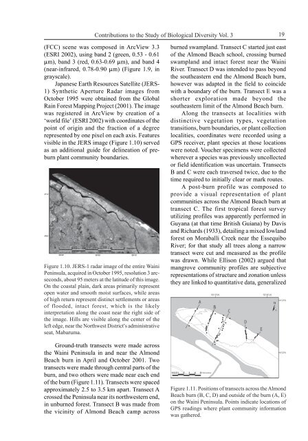
Figure 1.10. JERS-1 radar image of the entire Wa<strong>in</strong>i<br />
Pen<strong>in</strong>sula, acquired <strong>in</strong> October 1995, resolution 3 arcseconds,<br />
about 95 meters at the latitude of this image.<br />
On the coastal pla<strong>in</strong>, dark areas primarily represent<br />
open water <strong>and</strong> smooth moist surfaces, while areas<br />
of high return represent dist<strong>in</strong>ct settlements or areas<br />
of flooded, <strong>in</strong>tact forest, which is the likely<br />
<strong>in</strong>terpretation along the coast near the right side of<br />
the image. Hills are visible along the center of the<br />
left edge, near the Northwest District=s adm<strong>in</strong>istrative<br />
seat, Mabaruma.<br />
Ground-truth transects were made across<br />
the Wa<strong>in</strong>i Pen<strong>in</strong>sula <strong>in</strong> <strong>and</strong> near the Almond<br />
Beach burn <strong>in</strong> April <strong>and</strong> October 2001. Two<br />
transects were made through central parts of the<br />
burn, <strong>and</strong> two others were made near each end<br />
of the burn (Figure 1.11). Transects were spaced<br />
approximately 2.5 to 3.5 km apart. Transect A<br />
crossed the Pen<strong>in</strong>sula near its northwestern end,<br />
<strong>in</strong> unburned forest. Transect B was made from<br />
the vic<strong>in</strong>ity of Almond Beach camp across<br />
19<br />
burned swampl<strong>and</strong>. Transect C started just east<br />
of the Almond Beach school, cross<strong>in</strong>g burned<br />
swampl<strong>and</strong> <strong>and</strong> <strong>in</strong>tact forest near the Wa<strong>in</strong>i<br />
River. Transect D was <strong>in</strong>tended to pass beyond<br />
the southeastern end the Almond Beach burn,<br />
however was adapted <strong>in</strong> the field to co<strong>in</strong>cide<br />
with a boundary of the burn. Transect E was a<br />
shorter exploration made beyond the<br />
southeastern limit of the Almond Beach burn.<br />
Along the transects at localities with<br />
dist<strong>in</strong>ctive vegetation types, vegetation<br />
transitions, burn boundaries, or plant collection<br />
localities, coord<strong>in</strong>ates were recorded us<strong>in</strong>g a<br />
GPS receiver, plant species at those locations<br />
were noted. Voucher specimens were collected<br />
wherever a species was previously uncollected<br />
or field identification was uncerta<strong>in</strong>. Transects<br />
B <strong>and</strong> C were each traversed twice, due to the<br />
time required to <strong>in</strong>itially clear or mark routes.<br />
A post-burn profile was composed to<br />
provide a visual representation of plant<br />
communities across the Almond Beach burn at<br />
transect C. The first tropical forest survey<br />
utiliz<strong>in</strong>g profiles was apparently performed <strong>in</strong><br />
Guyana (at that time British Guiana) by Davis<br />
<strong>and</strong> Richards (1933), detail<strong>in</strong>g a mixed lowl<strong>and</strong><br />
forest on Moraballi Creek near the Essequibo<br />
River; for that study all trees along a narrow<br />
transect were cut <strong>and</strong> measured as the profile<br />
was drawn. While Ellison (2002) argued that<br />
mangrove community profiles are subjective<br />
representations of structure <strong>and</strong> zonation unless<br />
they are l<strong>in</strong>ked to quantitative data, generalized<br />
Figure 1.11. Positions of transects across the Almond<br />
Beach burn (B, C, D) <strong>and</strong> outside of the burn (A, E)<br />
on the Wa<strong>in</strong>i Pen<strong>in</strong>sula. Po<strong>in</strong>ts <strong>in</strong>dicate locations of<br />
GPS read<strong>in</strong>gs where plant community <strong>in</strong>formation<br />
was gathered.