Plant Community Structure, Fire Disturbance, and Recovery in ...
Plant Community Structure, Fire Disturbance, and Recovery in ...
Plant Community Structure, Fire Disturbance, and Recovery in ...

You also want an ePaper? Increase the reach of your titles
YUMPU automatically turns print PDFs into web optimized ePapers that Google loves.
Contributions to the Study of Biological Diversity Vol. 3<br />
CHAPTER 1.<br />
THE WAINI PENINSULA ENVIRONMENT AND ITS FLORA<br />
INTRODUCTION<br />
Any protected natural area is well served<br />
by the assembly of comprehensive basel<strong>in</strong>e<br />
<strong>in</strong>formation <strong>and</strong> by ongo<strong>in</strong>g environmental<br />
description <strong>and</strong> monitor<strong>in</strong>g. The broad goal of<br />
this chapter is to provide a detailed, <strong>in</strong>itial<br />
documentation of the plant species <strong>and</strong> plant<br />
communities of the Wa<strong>in</strong>i Pen<strong>in</strong>sula, to serve<br />
as a foundation for future studies <strong>and</strong><br />
management. The Wa<strong>in</strong>i Pen<strong>in</strong>sula is a proposed<br />
reserve <strong>in</strong> northern Guyana that has been known<br />
for its mar<strong>in</strong>e turtle nest<strong>in</strong>g beaches <strong>and</strong><br />
conservation activities. It is also the location of<br />
long stretches of coastal mangrove swamps,<br />
freshwater swamps, <strong>and</strong> extensive <strong>in</strong>tertidal<br />
mudflats that are habitat for many types of<br />
wildlife. Included are a description of the study<br />
site, a summary of the botanical collections<br />
made to document the flora, <strong>and</strong> descriptions<br />
of basic vegetation zones. The quantity of new<br />
distributional <strong>in</strong>formation revealed by plant<br />
collections activities is of scientific <strong>in</strong>terest, as<br />
that allows <strong>in</strong>sight <strong>in</strong>to the state of basic<br />
knowledge about an area, which guides future<br />
data gather<strong>in</strong>g efforts for research <strong>and</strong><br />
conservation activities. A more accurate<br />
del<strong>in</strong>eation of Guyana’s mangrove communities,<br />
which are of high conservation concern, is<br />
desirable consider<strong>in</strong>g the wide variations <strong>in</strong><br />
exist<strong>in</strong>g estimates for the country (Saenger et<br />
al. 1983; Snedaker 1986; Spald<strong>in</strong>g et al. 1997).<br />
As part of the plant community description, an<br />
estimate was also made of areas affected by the<br />
1998 soil fires on the Wa<strong>in</strong>i Pen<strong>in</strong>sula. Those<br />
fires were unusual for their impact to large areas<br />
of mangrove swamp, which is an ecosystem type<br />
normally considered to be unaffected by fire.<br />
Appendix 1 provides additional review of<br />
mangrove ecology <strong>in</strong> Guyana, <strong>in</strong>clud<strong>in</strong>g<br />
relationships to fire <strong>in</strong> the wet tropics. Appendix<br />
2 fully lists the plant species that were<br />
documented for the Wa<strong>in</strong>i Pen<strong>in</strong>sula.<br />
STUDY SITE<br />
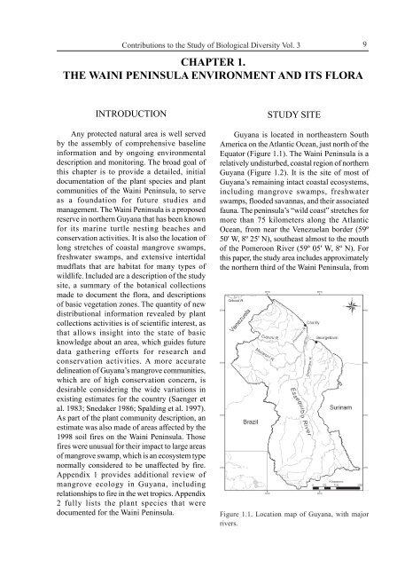
Guyana is located <strong>in</strong> northeastern South<br />
America on the Atlantic Ocean, just north of the<br />
Equator (Figure 1.1). The Wa<strong>in</strong>i Pen<strong>in</strong>sula is a<br />
relatively undisturbed, coastal region of northern<br />
Guyana (Figure 1.2). It is the site of most of<br />
Guyana’s rema<strong>in</strong><strong>in</strong>g <strong>in</strong>tact coastal ecosystems,<br />
<strong>in</strong>clud<strong>in</strong>g mangrove swamps, freshwater<br />
swamps, flooded savannas, <strong>and</strong> their associated<br />
fauna. The pen<strong>in</strong>sula’s “wild coast” stretches for<br />
more than 75 kilometers along the Atlantic<br />
Ocean, from near the Venezuelan border (59º<br />
50' W, 8º 25' N), southeast almost to the mouth<br />
of the Pomeroon River (59º 05' W, 8º N). For<br />
this paper, the study area <strong>in</strong>cludes approximately<br />
the northern third of the Wa<strong>in</strong>i Pen<strong>in</strong>sula, from<br />
Figure 1.1. Location map of Guyana, with major<br />
rivers.<br />
9