Biological Society of Washington - Department of Botany ...
Biological Society of Washington - Department of Botany ...
Biological Society of Washington - Department of Botany ...

Create successful ePaper yourself
Turn your PDF publications into a flip-book with our unique Google optimized e-Paper software.
2 BULLETIN OF THE BIOLOGICAL SOCIETY OF WASHINGTON<br />
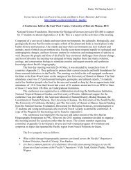
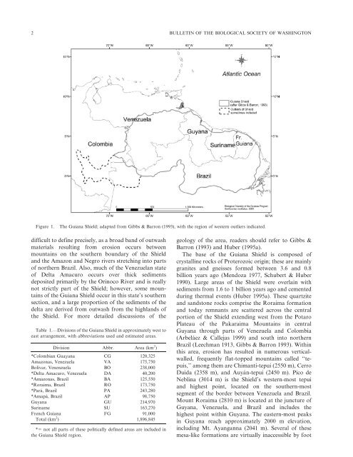
Figure 1. The Guiana Shield; adapted from Gibbs & Barron (1993), with the region <strong>of</strong> western outliers indicated.<br />
difficult to define precisely, as a broad band <strong>of</strong> outwash<br />
materials resulting from erosion occurs between<br />
mountains on the southern boundary <strong>of</strong> the Shield<br />
and the Amazon and Negro rivers stretching into parts<br />
<strong>of</strong> northern Brazil. Also, much <strong>of</strong> the Venezuelan state<br />
<strong>of</strong> Delta Amacuro occurs over thick sediments<br />
deposited primarily by the Orinoco River and is really<br />
not strictly part <strong>of</strong> the Shield; however, some mountains<br />
<strong>of</strong> the Guiana Shield occur in this state’s southern<br />
section, and a large proportion <strong>of</strong> the sediments <strong>of</strong> the<br />
delta are derived from outwash from the highlands <strong>of</strong><br />
the Shield. For more detailed discussions <strong>of</strong> the<br />
Table 1.—Divisions <strong>of</strong> the Guiana Shield in approximately west to<br />
east arrangement, with abbreviations used and estimated areas.<br />
Division Abbr. Area (km 2 )<br />
*Colombian Guayana CG 120,325<br />
Amazonas, Venezuela VA 175,750<br />
Bolívar, Venenzuela BO 238,000<br />
*Delta Amacuro, Venezuela DA 40,200<br />
*Amazonas, Brazil BA 125,550<br />
*Roraima, Brazil RO 173,750<br />
*Pará, Brazil PA 243,280<br />
*Amapá, Brazil AP 98,750<br />
Guyana GU 214,970<br />
Suriname SU 163,270<br />
French Guiana FG 91,000<br />
Total (km 2 ) 1,896,845<br />
*5 not all parts <strong>of</strong> these politically defined areas are included in<br />
the Guiana Shield region.<br />
geology <strong>of</strong> the area, readers should refer to Gibbs &<br />
Barron (1993) and Huber (1995a).<br />
The base <strong>of</strong> the Guiana Shield is composed <strong>of</strong><br />
crystalline rocks <strong>of</strong> Proterozoic origin; these are mainly<br />
granites and gneisses formed between 3.6 and 0.8<br />
billion years ago (Mendoza 1977, Schubert & Huber<br />
1990). Large areas <strong>of</strong> the Shield were overlain with<br />
sediments from 1.6 to 1 billion years ago and cemented<br />
during thermal events (Huber 1995a). These quartzite<br />
and sandstone rocks comprise the Roraima formation<br />
and today remnants are scattered across the central<br />
portion <strong>of</strong> the Shield extending west from the Potaro<br />
Plateau <strong>of</strong> the Pakaraima Mountains in central<br />
Guyana through parts <strong>of</strong> Venezuela and Colombia<br />
(Arbeláez & Callejas 1999) and south into northern<br />
Brazil (Leechman 1913, Gibbs & Barron 1993). Within<br />
this area, erosion has resulted in numerous verticalwalled,<br />
frequently flat-topped mountains called ‘‘tepuis,’’<br />
among them are Chimantí-tepui (2550 m), Cerro<br />
Duida (2358 m), and Auyán-tepui (2450 m). Pico de<br />
Neblina (3014 m) is the Shield’s western-most tepui<br />
and highest point, located on the southern-most<br />
segment <strong>of</strong> the border between Venezuela and Brazil.<br />
Mount Roraima (2810 m) is located at the juncture <strong>of</strong><br />
Guyana, Venezuela, and Brazil and includes the<br />
highest point within Guyana. The eastern-most peaks<br />
in Guyana reach approximately 2000 m elevation,<br />
including Mt. Ayanganna (2041 m). Several <strong>of</strong> these<br />
mesa-like formations are virtually inaccessible by foot